Investigating land use and carbon storage changes in Jinan metropolitan circle based on the InVEST-PLUS coupled model
XING Xiaotian1(), WANG Qi1, ZHAO Jiajun1, LIU Pudong1(), ZHANG Jingyuan2
1. School of Surveying and Mapping and Geographic Information, Shandong Jianzhu University, Jinan 250101, China 2. School of Art, Shandong Jianzhu University, Jinan 250101, China
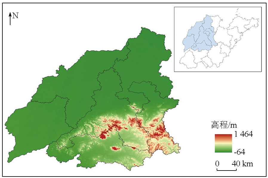
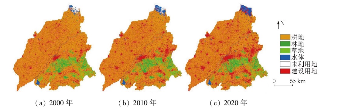
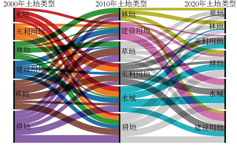
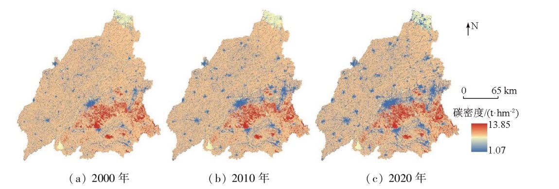
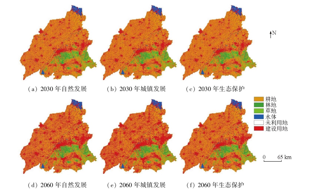
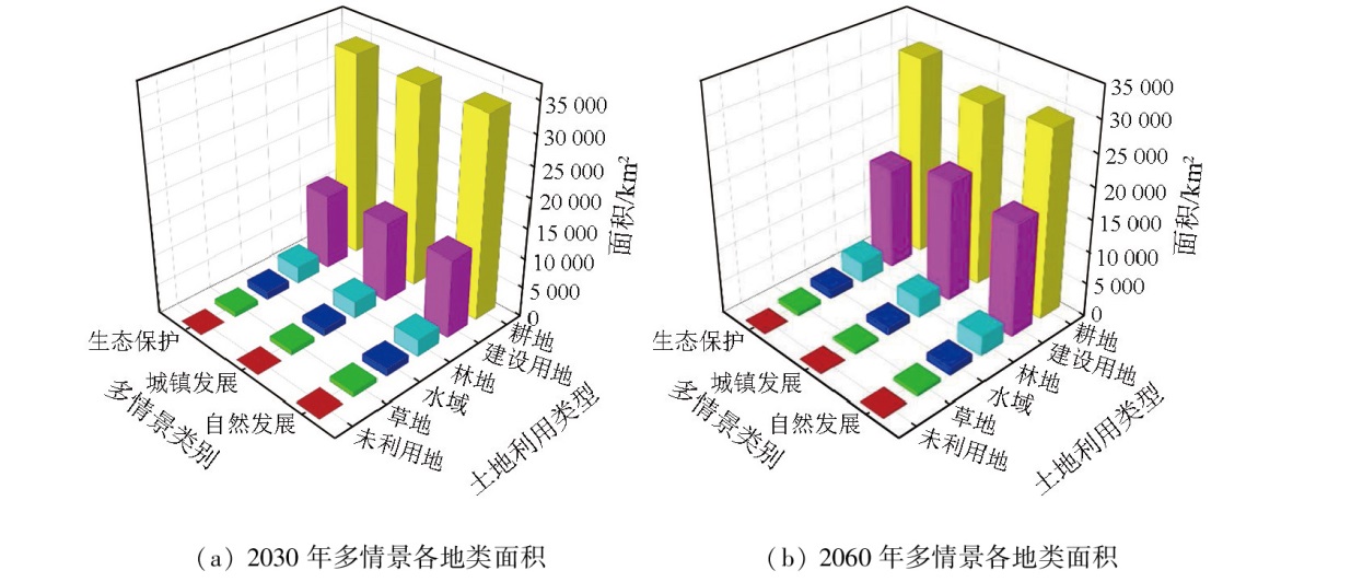
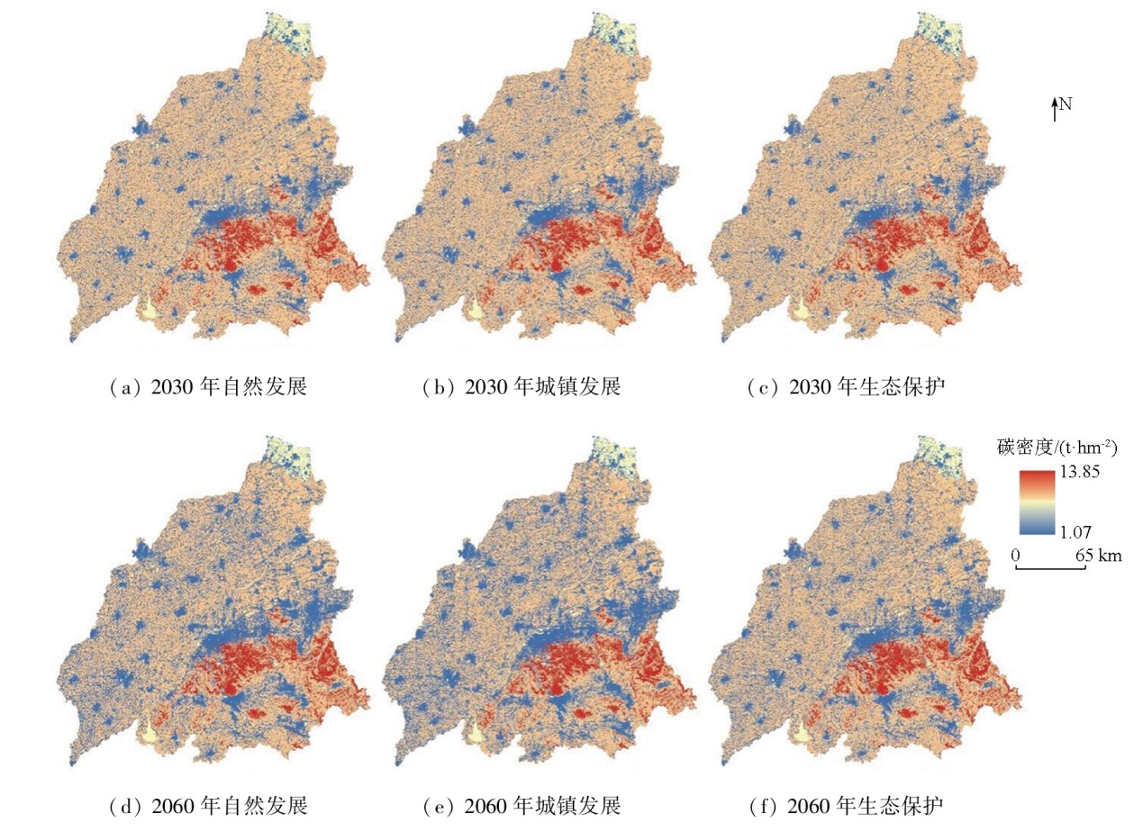
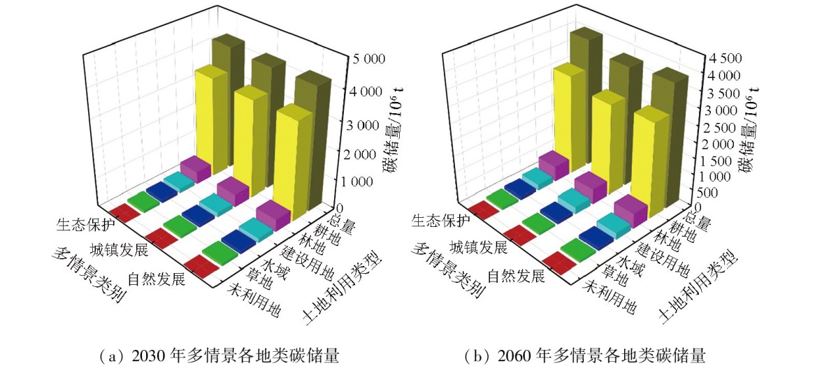
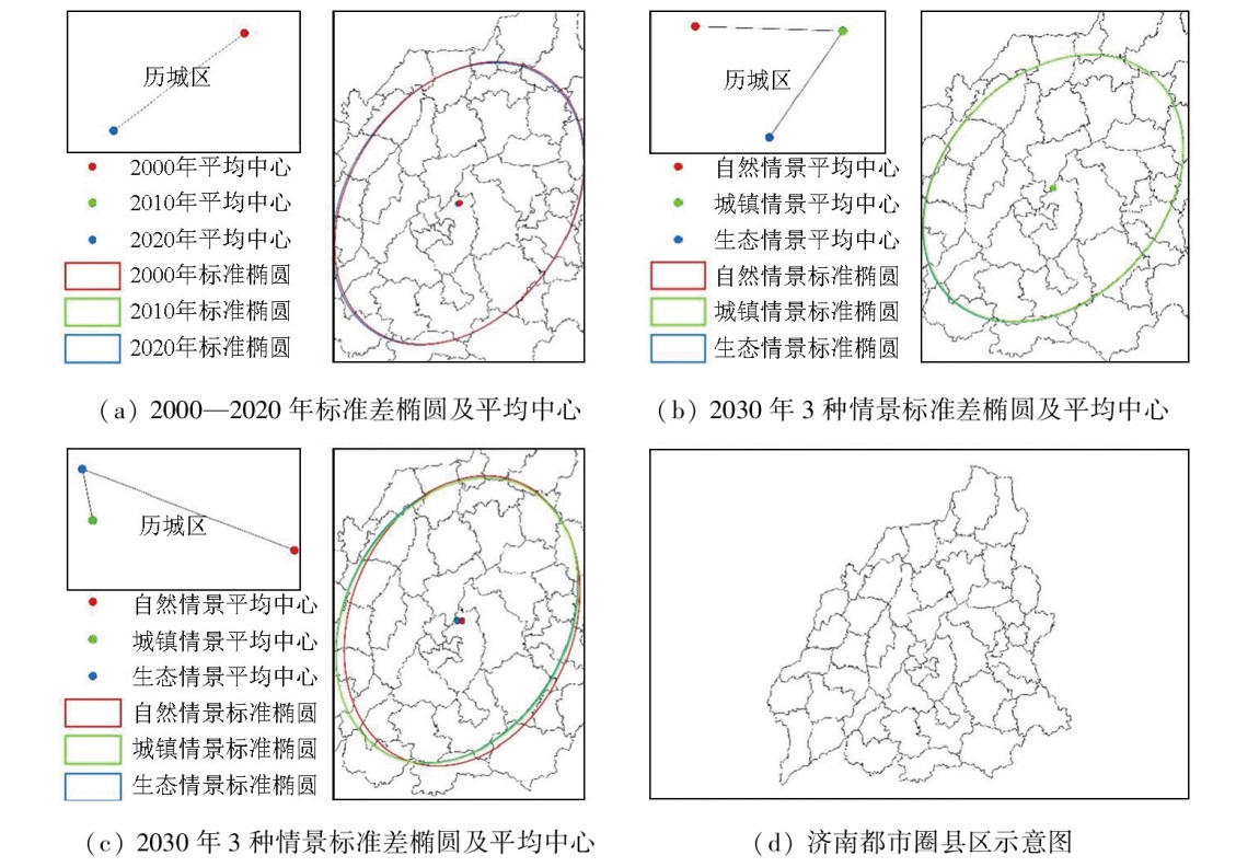
摘要探究土地利用演变及其对碳储量的影响,对于减缓都市圈气候变化、促进绿色低碳发展具有重要意义。该研究在“双碳”目标背景下,结合兴趣点(point of interest,POI)数据并顾及斑块生成土地利用模拟模型(patch-generating land use simulation model,PLUS)进行双约束转移矩阵优化,耦合生态系统服务与权衡的综合评估(integrated valuation of ecosystem services and trade-offs,InVEST)模型分析山东省济南都市圈2000—2020年土地利用演变规律及其对生态系统碳储量的影响,模拟预测了自然发展、城镇发展和生态保护3种情景下济南都市圈2030年和2060年土地利用变化并估算其生态系统碳储量,分析其碳储量重心迁移情况,并利用参数最优地理探测器探究碳储量空间分异驱动因素。结果表明: ①2000—2020年,济南都市圈耕地、草地和未利用地面积持续减少,林地面积呈波动增加状态,水域、建设用地面积增长迅速; ②2000—2020年,济南都市圈碳储量及土地利用空间格局相似,以黄河主脉为分界线,呈现“东南高,西北低”的分布特征,耕地类型碳储量为研究区碳储量的主要来源,占总碳储量的80%以上; ③多情景模拟下的碳储量均有所降低,主要原因为高碳密度区域耕地转换为低碳密度区域建设用地,其中生态保护情景碳储量最高,2030年总碳储量为4 226.86×10⁶ t,2060年总碳储量为3 967.94×10⁶ t; ④不同发展时期和情景下的济南都市圈碳储量重心均发生一定偏移,发展趋势受土地利用变化影响,重心地带一直处于济南市历城区,说明济南都市圈发展较为全面均衡; ⑤各驱动因子对济南都市圈碳储量空间分布具有明显影响,其中人口密度对碳储量空间分异解释力最大,交互作用下各因子均呈现对碳储量解释力增强的结果。
Exploring land use evolution and its impact on carbon storage is significant for mitigating climate change and promoting green and low-carbon development in metropolitan circles. Under the carbon peak and neutrality goals, this study implemented dual-constraint transition matrix optimization using point-of-interest (POI) data and the patch-generating land use simulation (PLUS) model, followed by the coupling with the integrated valuation of ecosystem services and trade-offs (InVEST) model. Based on the InVEST-PLUS coupled model, this study analyzed the land use evolution in the Jinan metropolitan circle from 2000 to 2020 and its impact on ecosystem carbon storage. Considering natural development, urban development, and ecological conservation as three distinct scenarios, this study simulated and predicted the land use change in the Jinan metropolitan circle in 2030 and 2060. Moreover, this study estimated the corresponding ecosystem carbon storage and analyzed the shift of the carbon storage center. Finally, this study explored the factors driving the spatial differentiation of carbon storage using the optimal parameters-based geographical detector (OPGD). The results indicate that from 2000 to 2020, the Jinan metropolitan circle saw a continued decrease in arable land, grassland, and unused land; a fluctuating increase in forest land; and a rapid increase in water area and construction land. The carbon storage and land use pattern in the Jinan metropolitan circle showed similar distributions characterized by higher values in the southeast and lower values in the northwest, with the main body of the Yellow River as the dividing line. The carbon storage in arable land served as the primary source of carbon storage in the Jinan metropolitan circle since it represented over 80 % of the total carbon storage. The simulation results reveal decreased carbon storage under the three scenarios, primarily due to the conversion from arable land in high carbon-density areas to construction land in low carbon-density areas. The ecological conservation scenario shows the highest total estimated carbon storage, which is 4 226.86×10⁶ t in 2030 and 3 967.94×10⁶ t in 2060. The carbon storage center in the Jinan metropolitan circle displays a certain shift in different development periods and scenarios due to land use change. However, the carbon storage center remains located in Licheng District, suggesting that the development of the Jinan metropolitan circle is relatively comprehensive and balanced. Various driving factors manifest significant impacts on the spatial distribution of carbon storage in the Jinan metropolitan circle. Notably, population density shows the greatest explanatory power for the spatial differentiation of carbon storage. Additionally, the interactions of various factors enhance their explanatory power for carbon storage.
邢笑天, 王琪, 赵佳俊, 刘浦东, 张靖苑. 耦合InVEST—PLUS模型的济南都市圈土地利用及碳储量变化研究[J]. 自然资源遥感, 2025, 37(4): 118-130.
XING Xiaotian, WANG Qi, ZHAO Jiajun, LIU Pudong, ZHANG Jingyuan. Investigating land use and carbon storage changes in Jinan metropolitan circle based on the InVEST-PLUS coupled model. Remote Sensing for Natural Resources, 2025, 37(4): 118-130.
Sun H Y, Gong Q Q, Liu Q G, et al. Spatio-temporal evolution of habitat quality based on the land-use changes in Shandong Province[J]. Chinese Journal of Soil Science, 2022, 53(5):1019-1028.
Long W J, Zhi L, Guo Y D, et al. Spatiotemporal evolution and origin of carbon stock in the West Dongting Lake National Nature Reserve over the last two decades[J]. Remote Sensing for Natural Resources, 2024, 36(4):185-192.doi:10.6046/zrzyyg.2023265.
[3]
Houghton R A. Revised estimates of the annual net flux of carbon to the atmosphere from changes in land use and land management 1850—2000[J]. Tellus B, 2003, 55(2):378-390.
[4]
Lin X, Fu H. Spatial-temporal evolution and driving forces of cultivated land based on the PLUS model:A case study of Haikou city,1980—2020[J]. Sustainability, 2022, 14(21):14284.
Yang L W, Zhao J, Zhu J T, et al. Spatial-temporal change and prediction of carbon stock in the ecosystem of Xi’an based on PLUS and InVEST models[J]. Remote Sensing for Natural Resources, 2022(4):175-182.doi:10.6046/zrzyyg.2021348.
[6]
Feng Y, Chen S, Tong X, et al. Modeling changes in China’s 2000-2030 carbon stock caused by land use change[J]. Journal of Cleaner Production, 2020, 252:119659.
Yang Y H, Shi Y, Sun W J, et al. Terrestrial carbon sinks in China and around the world and their contribution to carbon neutrality[J]. Scientia Sinica (Vitae), 2022, 52(4):534-574.
Fang J Y, Yu G R, Ren X B, et al. Carbon sequestration in China’s terrestrial ecosystems under climate change—Progress on ecosystem carbon sequestration from the CAS strategic priority research program[J]. Bulletin of Chinese Academy of Sciences, 2015, 30(6):848-857.
Jia T C, Hu X W, Zhang Nana. Study on ecological security assessment and obstacle actors of Sanjiangyuan National Park[J]. Journal of Hebei University of Environmental Engineering, 2023, 33(1):48-54.
Li J K, Shao Z L. Spatiotemporal evolution and prediction of carbon stock in Urumqi City based on PLUS and InVEST models[J]. Arid Zone Research, 2024, 41(3):499-508.
doi: 10.13866/j.azr.2024.03.14
Wang Z H, Wang B, Zhang Y F, et al. Dynamic simulation of multi-scenario land use change and carbon storage assessment in Hohhot City based on PLUS-InVEST model[J]. Journal of Agricultural Resources and Environment, 2024, 41(2):292-304.
[12]
He C, Zhang D, Huang Q, et al. Assessing the potential impacts of urban expansion on regional carbon storage by linking the LUSD-urban and InVEST models[J]. Environmental Modelling and Software, 2016, 75:44-58.
[13]
Yang B, Chen X, Wang Z, et al. Analyzing land use structure efficiency with carbon emissions:A case study in the Middle Reaches of the Yangtze River,China[J]. Journal of Cleaner Production, 2020, 274:123076.
Li Z H, Yu H, Gong F, et al. Temporal and spatial evolution analysis of habitat quality in ecologically vulnerable areas based on PLUS-InVEST model[J]. Hubei Agricultural Sciences, 2024, 63(2):254-260.
[15]
Piyathilake I D U H, Udayakumara E P N, Ranaweera L V, et al. Modeling predictive assessment of carbon storage using InVEST model in Uva Province,Sri Lanka[J]. Modeling Earth Systems and Environment, 2022, 8(2):2213-2223.
[16]
Zhao M, He Z, Du J, et al. Assessing the effects of ecological engineering on carbon storage by linking the CA-Markov and InVEST models[J]. Ecological Indicators, 2019, 98:29-38.
Fu K X, Jia G D, Yu X X, et al. Analysis of temporal and spatial carbon stock changes and driving mechanism in Xinjiang Region by coupled PLUS-InVEST-geodector model[J]. Environmental Science, 2024, 45(9):5416-5430.
Xu A K, Hu M J, Shi J, et al. Spatial and temporal variability of ecosystem carbon storages and multi-scenario simulation in the Shiyang River Basin[J]. China Environmental Science, 2024, 44(6):3365-3375.
[19]
卢震. 未来蓝图“过审” 济南都市圈乘风而起[N]. 济南日报,2024-01-30(1).
Lu Z. Future blueprint approved: Jinan Metropolitan Area rides the wave[N]. Jinan Daily,2024-01-30(1).
Li K, Hou Y, Fu Q, et al. Synergistic changes of production-living-ecology spaces and their influences on ecosystem services in the metropolitan area[J]. Research of Soil and Water Conservation, 2023, 30(3):430-439.
Feng Y F, Li C, Feng J M. Spatiotemporal response of ecosystem service value in Jinan metropolitan area to urban expansion based on GTWR model[J]. Journal of Beijing Forestry University, 2024, 46(1):104-118.
[22]
Chen C, Liu J, Bi L. Spatial and temporal changes of habitat quality and its influential factors in China based on the InVEST model[J]. Forests, 2023, 14(2):374.
Ding Y, Wang L Z, Gui F, et al. Ecosystem carbon storage in Hangzhou Bay Area based on InVEST and PLUS models[J]. Environmental Science, 2023, 44(6):3343-3352.
Yu Z L, Zhao M S, Gao Y F, et al. Spatio-temporal evolution and prediction of carbon storage in Huaibei City based on InVEST-PLUS model[J]. Environmental Science, 2024, 45(6):3270-3283.
Bian R, Zhao A Z, Liu X F, et al. Impact of land use change on carbon storage in urban agglomerations in the Guanzhong Plain[J]. Environmental Science, 2024, 45(6):3260-3269.
[27]
秦慧颖. 山东省土地利用情景模拟与生态系统服务预测[D]. 济南: 山东大学, 2022.
Qin H Y. Scenario simulation of land use and prediction of ecosystem services in Shandong Province[D]. Jinan: Shandong University, 2022.
[28]
Gao L, Tao F, Liu R, et al. Multi-scenario simulation and ecological risk analysis of land use based on the PLUS model:A case study of Nanjing[J]. Sustainable Cities and Society, 2022, 85:104055.
Lin T, Yang M Z, Wu D F, et al. Spatial correlation and prediction of land use carbon storage based on the InVEST-PLUS model:A case study in Guangdong Province[J]. China Environmental Science, 2022, 42(10):4827-4839.
Liang T, Huang Q, Yang F, et al. Evolution and prediction of habitat quality in the Three Gorges Reservoir(Chongqing section)based on the in VEST-PLUS model[J]. Resources and Environment in the Yangtze Basin, 2023, 32(10):2184-2195.
[31]
Zhang S, Zhong Q, Cheng D, et al. Landscape ecological risk projection based on the PLUS model under the localized shared socioeconomic pathways in the Fujian Delta Region[J]. Ecological Indicators, 2022, 136:108642.
Mao Y F, Zhou Q G, Wang T, et al. Spatial-temporal variation of carbon storage and its quantitative attribution in the Three Gorges Reservoir Area coupled with PLUS-InVEST geodector model[J]. Resources and Environment in the Yangtze Basin, 2023, 32(5):1042-1057.
Shao Z, Chen R, Zhao J, et al. Spatio-temporal evolution and prediction of carbon storage in Beijing’s ecosystem based on FLUS and InVEST models[J]. Acta Ecologica Sinica, 2022, 42(23):9456-9469.
Reply of the “Land and Spatial Planning of Shandong Province (2021-2035)”[J]. Gazette of the State Council of the People’s Republic of China, 2023(29):19-20.
Luo S Q, Hu X M, Sun Y, et al. Multi-scenario land use change and its impact on carbon storage based on coupled Plus-Invest model[J]. Chinese Journal of Eco-Agriculture, 2023(2):300-314.
Li J, Yang D H, Wu F Z, et al. Dynamic simulation of land use changes and assessment of carbon storage in Kunming City based on PLUS and in VEST models[J]. Bulletin of Soil and Water Conservation, 2023, 43(1):378-387.
[38]
Liang X, Guan Q, Clarke K C, et al. Understanding the drivers of sustainable land expansion using a patch-generating land use simulation (PLUS) model:A case study in Wuhan,China[J]. Computers,Environment and Urban Systems, 2021, 85:101569.
Shi J, Shi P J, Wang Z Y, et al. Spatial-temporal evolution and prediction of carbon storage in Jiuquan city ecosystem based on PLUS-InVEST model[J]. Environmental Science, 2024, 45(1):300-313.
Li C, Wu Y M, Gao B P, et al. Spatial differentiation and driving factors of rural settlement in plateau lake:A case study of the area around the Erhai[J]. Economic Geography, 2022, 42(4):220-229.
Wang K, Piao S L, He Y, et al. Spatial variations and mechanisms for the stability of terrestrial carbon sink in China[J]. Scientia Sinica (Terrae), 2023, 53(2):216-226.
 2025, Vol. 37
  ), 王琪1, 赵佳俊1, 刘浦东1(