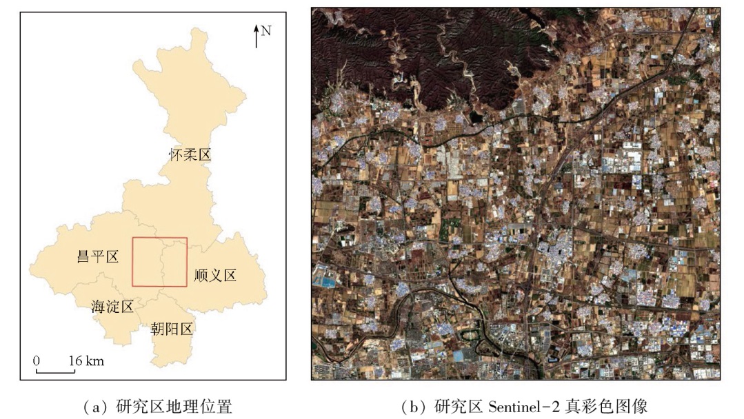
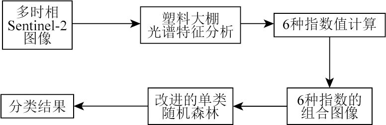
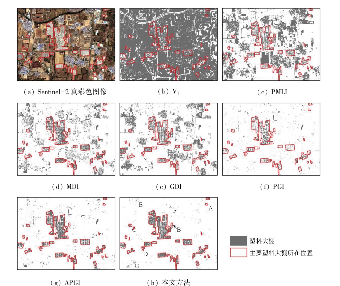
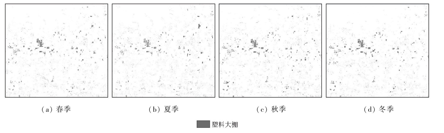
Plastic greenhouses have gained extensive application in modern agriculture. This, however, gives rise to ecological issues. Remote sensing data enable effective extraction and identification of plastic greenhouses on a large scale. Existing studies largely focus on plastic greenhouse extraction using either classification or spectral indices methods. However, there exists a lack of the combination and comparative analysis of both methods. This study proposed a method for plastic greenhouse extraction that integrates multiple Sentinel-2 spectral indices and a one-class classification method (improved one-class random forest). Furthermore, this study extracted information on plastic greenhouses using an improved one-class random forest method, as well as six spectral indices of plastic greenhouses as classification features. The extraction results were then compared with those of the proposed method to demonstrate the effectiveness of the latter. The results indicate that the proposed method yielded an overall accuracy of above 97% across four seasons, with kappa coefficients exceeding 0.82 and F1 scores of over 0.84. These metrics all were better than those yielded using the six spectral indices. Furthermore, the proposed method exhibited differences in the overall accuracy, kappa coefficient, and F1 score across four seasons of less than 1%, under 0.1, and below 0.1 respectively. This suggests the high seasonal stability of the method, outperforming the extraction results obtained by using spectral indices alone. This study provides a method for accurately monitoring the spatial distribution of plastic greenhouses.
肖明珠, 李培军. 利用Sentinel-2光谱指数和改进的单类随机森林的塑料大棚提取方法[J]. 自然资源遥感, 2025, 37(4): 40-47.
XIAO Mingzhu, LI PeiJjun. A method for plastic greenhouse extraction integrating Sentinel-2 spectral indices and an improved one-class random forest. Remote Sensing for Natural Resources, 2025, 37(4): 40-47.
Picuno P. Innovative material and improved technical design for a sustainable exploitation of agricultural plastic film[J]. Polymer-Plastics Technology and Engineering, 2014, 53(10):1000-1011.
[2]
Li J. Economic analysis of agro-film pollution in Xinjiang region[J]. Bord.Econ.Culture, 2008, 1(1):16-17.
Zheng L, He Z M, Ding H Y. Research on the sparse plastic shed extraction from high resolution images using ENVINet 5 deep lear-ning method[J]. Remote Sensing Technology and Application, 2021, 36(4):908-915.
[4]
Aguilar M A, Bianconi F, Aguilar F J, et al. Object-based greenhouse classification from GeoEye-1 and WorldView-2 stereo ima-gery[J]. Remote Sensing, 2014, 6(5):3554-3582.
[5]
Aguilar M A, Jiménez-Lao R, Aguilar F J. Evaluation of object-based greenhouse mapping using WorldView-3 VNIR and SWIR data:A case study from Almería (Spain)[J]. Remote Sensing, 2021, 13(11):2133.
[6]
Wu C F, Deng J S, Wang K, et al. Object-based classification approach for greenhouse mapping using Landsat8 imagery[J]. International Journal of Agricultural and Biological Engineering, 2016, 9(1):79-88.
[7]
Zhang P, Du P J, Guo S C, et al. A novel index for robust and large-scale mapping of plastic greenhouse from Sentinel-2 images[J]. Remote Sensing of Environment, 2022, 276:113042.
[8]
Lin J H, Jin X B, Ren J, et al. Rapid mapping of large-scale greenhouse based on integrated learning algorithm and Google Earth engine[J]. Remote Sensing, 2021, 13(7):1245.
[9]
Nemmaoui A, Aguilar M A, Aguilar F J, et al. Greenhouse crop identification from multi-temporal multi-sensor satellite imagery using object-based approach:A case study from Almería (Spain)[J]. Remote Sensing, 2018, 10(11):1751.
[10]
Novelli A, Aguilar M A, Nemmaoui A, et al. Performance evaluation of object based greenhouse detection from Sentinel-2 MSI and Landsat8 OLI data:A case study from Almería (Spain)[J]. International Journal of Applied Earth Observation and Geoinformation, 2016, 52(1):403-411.
[11]
Baghirli O, Ibrahimli I, Mammadzada T. Greenhouse segmentation on high-resolution optical satellite imagery using deep learning techniques[J]. ArXiv, 2020: 2007.
[12]
Zhao G X, Li J, Li T, et al. Utilizing landsat TM imagery to map greenhouses in Qingzhou,Shandong Province,China[J]. Pedosphere, 2004, 14(3):363-369
[13]
Lu L Z, Di L P, Ye Y M, A decision-tree classifier for extracting transparent plastic-mulched landcover from Landsat5 TM images[J]. IEEE Journal of Selected Topics in Applied Earth Observations and Remote Sensing, 2014, 7(11):4548-4558.
[14]
Aguilar M A, Nemmaoui A, Novelli A, et al. Object-based greenhouse mapping using very high resolution satellite data and Landsat 8 time series[J]. Remote Sensing, 2016, 8(6):513.
[15]
González-Yebra Ó, Aguilar M A, Nemmaoui A, et al. Methodological proposal to assess plastic greenhouses land cover change from the combination of archival aerial orthoimages and Landsat data[J]. Biosystems Engineering, 2018,175:36-51.
[16]
Yang D D, Chen J, Zhou Y, et al. Mapping plastic greenhouse with medium spatial resolution satellite data:Development of a new spectral index[J]. ISPRS Journal of Photogrammetry and Remote Sensing, 2017, 128:47-60.
[17]
Deng C B, Wu C S. BCI:A biophysical composition index for remote sensing of urban environments[J]. Remote Sensing of Environment, 2012, 127:247-259.
Shi Z K, Li P J, Luo L, et al. A method for extraction of newly-built buildings in road region using morphological attribute profiles and one-class random forest[J]. Acta Scientiarum Naturalium Universitatis Pekinensis, 2018, 54(1):105-114.
[19]
Désir C, Bernard S, Petitjean C, et al. One class random forests[J]. Pattern Recognition, 2013, 46(12):3490-3506.
[20]
Oshiro T M, Perez P S, Baranauskas J A. How many trees in a random forest?[C]// Machine Learning and Data Mining in Pattern Recognition:8th International Conference. Berlin Heidelberg. Springer, 2012: 154-168.
[21]
Bernard S, Heutte L, Adam S. Influence of hyperparameters on random forest accuracy[C]// Multiple Classifier Systems:8th International Workshop. Berlin Heidelberg. Springer, 2009: 171-180.
[22]
Tian L, Wang Z, Xue B, et al. A disease-specific spectral index tracks Magnaporthe oryzae infection in paddy rice from ground to space[J]. Remote Sensing of Environment, 2023, 285:113384.
[23]
Fisher R A. The use of multiple measurements in taxonomic problems[J]. Annals of Eugenics, 1936, 7(2):179-188.
 2025, Vol. 37
  ), 李培军(