Optical remote sensing-based cloud detection and extraction method for tropical and subtropical vegetation areas
HUANG Fe1,2(), WANG Xiaoqiong2, NIE Guanrui1, YAN Jun3, LI Xianyi3, TIAN Jia4, ZHU Cuicui2, LI Qianjing2, TIAN Qingjiu2()
1. Key Laboratory of Urban Land Resources Monitoring and Simulation, Ministry of Natural Resources, Shenzhen 518034, China 2. International Institute for Earth System Science, Nanjing University, Nanjing 210023, China 3. Zhuhai Orbita Aerospace Science & Technology Co., Ltd., Zhuhai 519000, China 4. School of Instrumentation and Optoelectronic Engineering, Beihang University, Beijing 100191, China
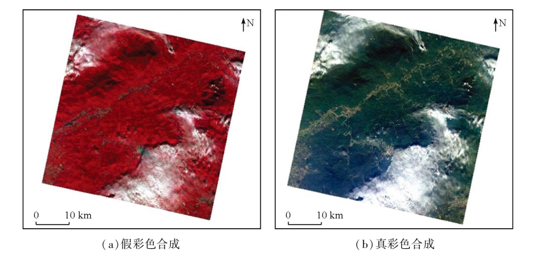
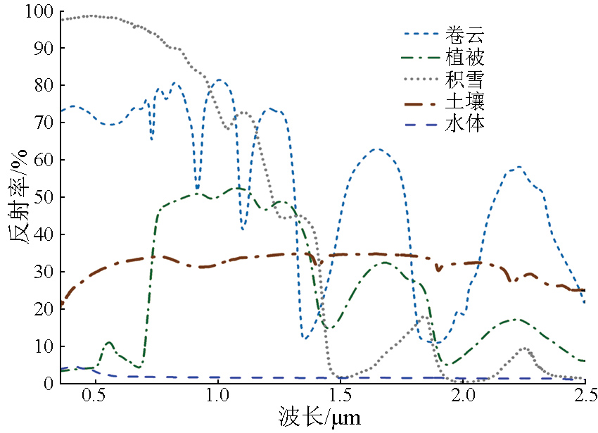
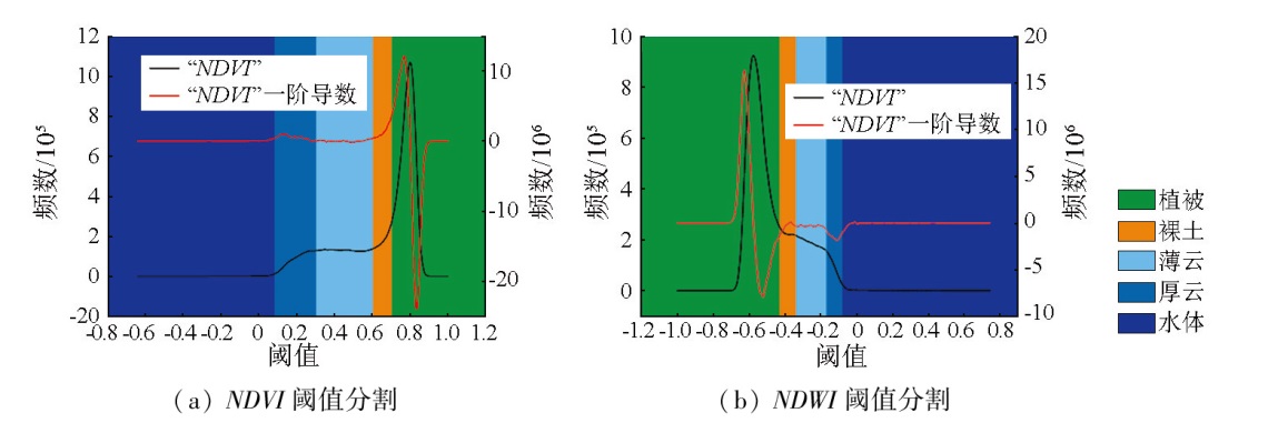
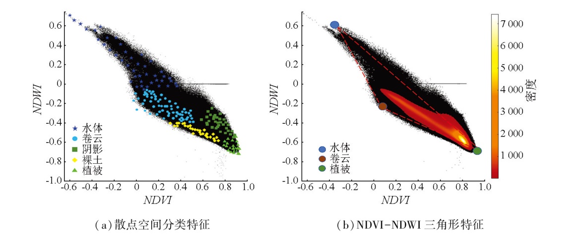
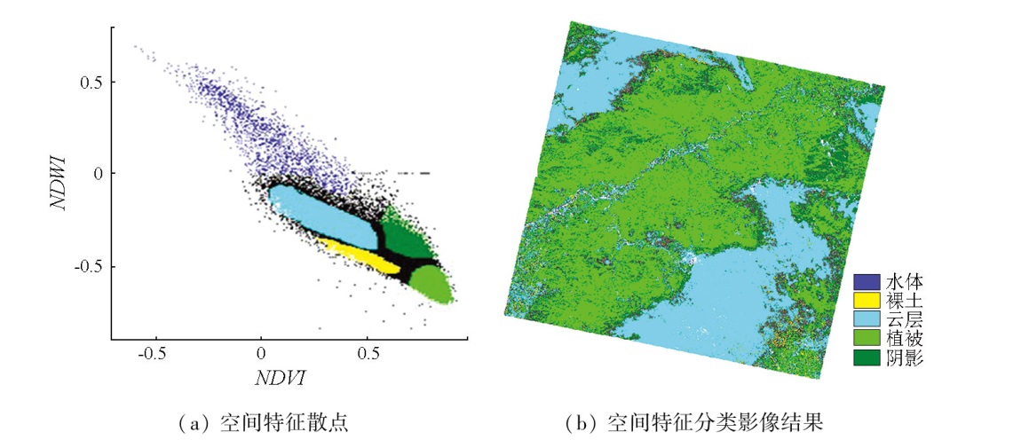
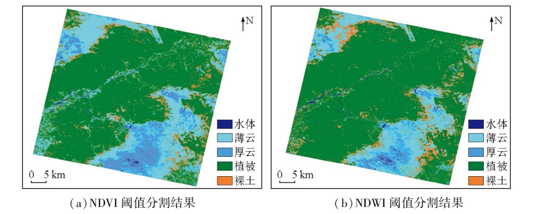
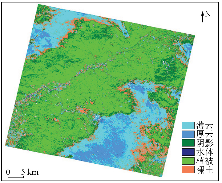
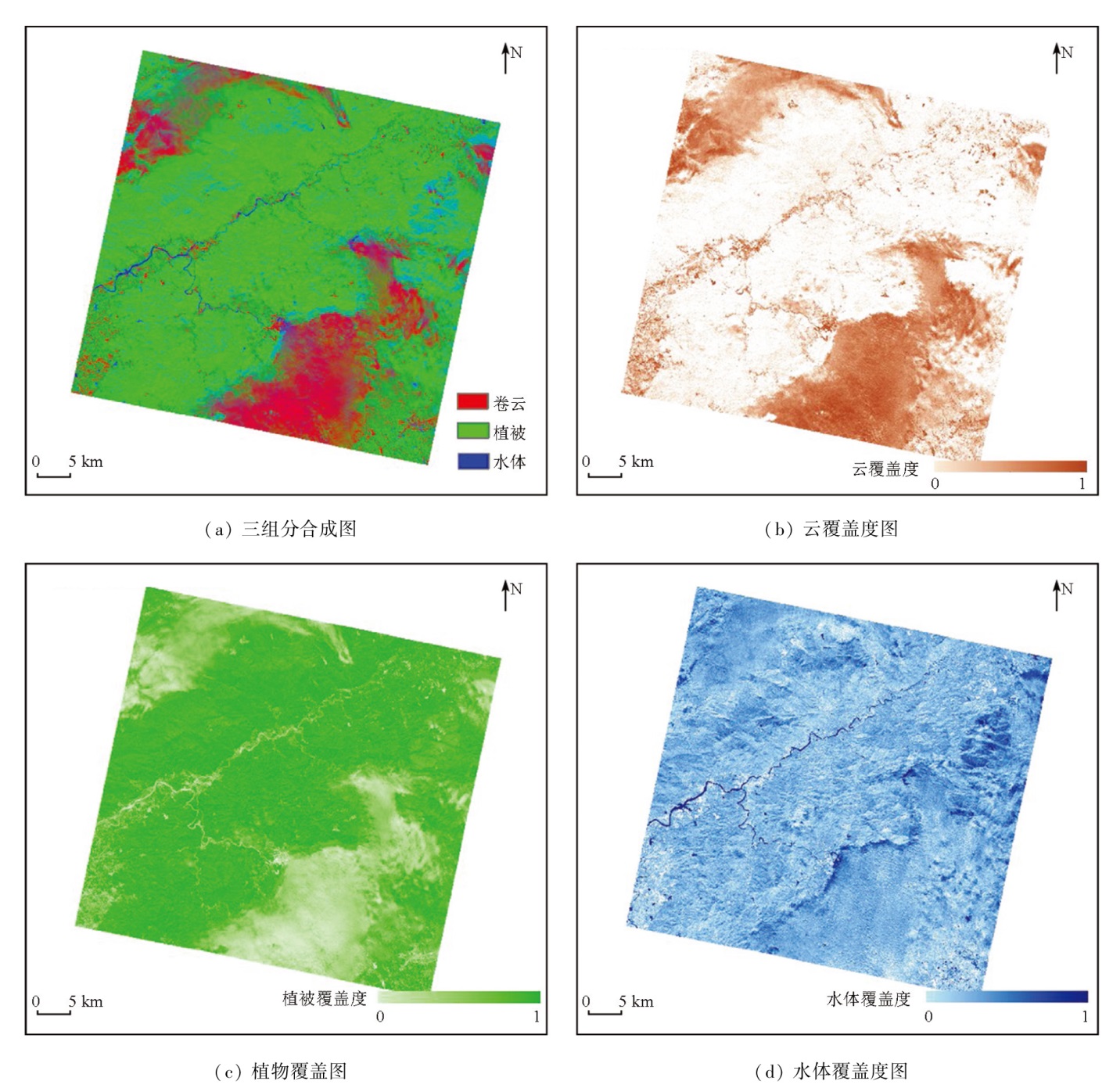
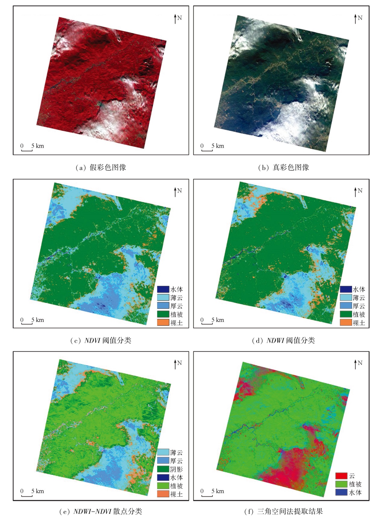
Optical satellite remote sensing images of tropical and subtropical vegetation areas are often affected by cloud cover, leading to missing remote sensing information of surface features. Effectively detecting clouds, classifying clouds and objects, and extracting cloud cover information remain hot topics and challenges in remote sensing research. Many optical cameras in domestic satellites lack the short-wave and thermal infrared spectral bands, which are used in prevailing cloud detection algorithms, reducing the image data availability after cloud removal. Hence, this study suggested detecting the spatial distribution of cloud cover by utilizing only several spectral bands in the visible light - near-infrared range (400 nm to 1 000 nm). Based on the hyperspectral remote sensing images from the Zhuhai-1 satellite, this study constructed feature space scatter plots using spectral indices, including normalized difference vegetation index (NDVI) and normalized differential water index (NDWI), for cloud/object classification and detection. Moreover, this study extracted the cloud, water, and vegetation cover information from mixed pixels. The results demonstrate that compared to conventional cloud detection methods using spectral index thresholds, the cloud detection algorithm under the NDWI-NDVI feature space used in this study exhibited a superior cloud-water separation capability and simple operability. It can precisely describe the spatial distribution characteristics of cloud cover by suppressing the shadow effect on cloud cover. Overall, this study offers a novel technical approach for further developing cloud detection, cloud-water separation, and cloud cover information extraction algorithms for domestic optical satellite remote sensing data.
Chen J L, Zhang J S, Duan Y M, et al. A review of cloud detection and thick cloud removal in medium resolution remote sensing images[J]. Remote Sensing Technology and Application, 2023, 38(1):143-155.
[2]
Saunders R W. An automated scheme for the removal of cloud contamination from AVHRR radiances over western Europe[J]. International Journal of Remote Sensing, 1986, 7(7):867-886.
Zhu Z R, Zhang X Y, Zeng Y Y, et al. Accuracy analysis of data processing for long baseline based on TBC 4.0 software[J]. Bulletin of Surveying and Mapping, 2018(4):146-149.
doi: 10.13474/j.cnki.11-2246.2018.0129
Zhong L, Cui W G, Ao D C, et al. Three kinds of GPS baselines processing software solution precision analysis[J]. Geomatics and Spatial Information Technology, 2018, 41(2):90-93.
Hu Y X, Wang Z, Zhang H D, et al. Comparison and application research of TBC and LGO in GNSS data processing[J]. Urban Geotechnical Investigation & Surveying, 2018(2):115-118.
[6]
张明波. 高分辨率遥感图像云检测方法研究[D]. 大连: 大连海事大学, 2018.
Zhang M B. Research on cloud detection method of high resolution remote sensing image[D]. Dalian: Dalian Maritime University, 2018.
Ji S Z. Research on cloud detection method of real-time remote sensing image based on convolutional neural network[D]. Harbin: Harbin Institute of Technology, 2021.
Yang B, Guo J Y, He P, et al. Research on cloud detection for HY-1C CZI remote sensing images collected over lands[J]. National Remote Sensing Bulletin, 2023, 27(1):55-67.
Hu C M, Zhang Z, Tang P. Research on multispectral satellite image cloud and cloud shadow detection algorithm of domestic sate-llite[J]. National Remote Sensing Bulletin, 2023, 27(3):623-634.
[10]
Li Z W, Shen H F, Li H F, et al. Multi-feature combined cloud and cloud shadow detection in GaoFen-1 wide field of view imagery[J]. Remote Sensing of Environment, 2017(191):342-58.
Feng S Y, Zhang N, Shen J, et al. Method of cloud detection with hyperspectral remote sensing image based on the reflective characteristics[J]. Chinese Optics, 2015, 8(2):198-204.
Zhao X, Hou Q Y, Liang B B, et al. A method for cloud detection in high-resolution remote sensing image based on multi-attribute fusion[J]. Optical Technique, 2014, 40(2):145-150.
Xu D Y, Li X R, Zhao L Y, et al. Hyperspectral remote sensing image cloud detection based on spectral analysis and dynamic fractal dimension[J]. Laser and Optoelectronics Progress, 2019, 56(10):101003.
[14]
Sun L, Yang X, Jia S, et al. Satellite data cloud detection using deep learning supported by hyperspectral data[J]. International Journal of Remote Sensing, 2020, 41(4):1349-1371.
Sui S M, Jia S F, Hu X Q. Improvement of unified sample cloud detection technology and its application in GF-6 WFV cloud detection[J]. National Remote Sensing Bulletin, 2022, 26(4):646-656.
Gao X J, Wan Y C, Zheng S Y, et al. Real-time automatic cloud detection during the process of taking aerial photographs[J]. Spectroscopy and Spectral Analysis, 2014, 34(7):1909.
[18]
Irish R R, Barker J L, Goward S N, et al. Characterization of the Landsat7 ETM+ automated cloud-cover assessment (ACCA) algorithm[J]. Photogrammetric Engineering and Remote Sensing, 2006, 72(10):1179-1188.
[19]
Zhu Z, Wang S, Woodcock C E. Improvement and expansion of the Fmask algorithm:Cloud,cloud shadow,and snow detection for Landsats4-7,8,and Sentinel 2 images[J]. Remote Sensing of Environment, 2015, 159:269-277.
[20]
Tucker C J. Red and photographic infrared linear combinations for monitoring vegetation[J]. Remote Sensing of Environment, 1979, 8(2):127-150.
[21]
Usman M, Liedl R, Shahid M A, et al. Land use/land cover classification and its change detection using multi-temporal MODIS NDVI data[J]. Journal of Geographical Sciences, 2015, 25(12):1479-1506.
doi: 10.1007/s11442-015-1247-y
[22]
Baeza S, Paruelo J M. Land use/land cover change (2000-2014) in the Rio de la plata grasslands:An analysis based on MODIS NDVI time series[J]. Remote Sensing, 2020, 12(3):381.
[23]
Kodl G, Streeter R, Cutler N, et al. Arctic tundra shrubification can obscure increasing levels of soil erosion in NDVI assessments of land cover derived from satellite imagery[J]. Remote Sensing of Environment, 2024, 301:113935.
[24]
Gao B C. NDWI—a normalized difference water index for remote sensing of vegetation liquid water from space[J]. Remote Sensing of Environment, 1996, 58(3):257-266.
[25]
Huang D Y, Wang C H. Optimal multi-level thresholding using a two-stage Otsu optimization approach[J]. Pattern Recognition Letters, 2009, 30(3):275-284.
[26]
Rosin P L. Unimodal thresholding[J]. Pattern Recognition, 2001, 34(11):2083-2096.
[27]
Xu X, Xu S, Jin L, et al. Characteristic analysis of Otsu threshold and its applications[J]. Pattern Recognition Letters, 2011, 32(7):956-961.
[28]
Sobrino J A, Raissouni N, Li Z L. A comparative study of land surface emissivity retrieval from NOAA data[J]. Remote Sensing of Environment, 2001, 75(2):256-266.
[29]
Tian J, Su S, Tian Q, et al. A novel spectral index for estimating fractional cover of non-photosynthetic vegetation using near-infrared bands of Sentinel satellite[J]. International Journal of Applied Earth Observation and Geoinformation, 2021, 101:102361.
[30]
Goodwin N, Coops N C, Stone C. Assessing plantation canopy condition from airborne imagery using spectral mixture analysis and fractional abundances[J]. International Journal of Applied Earth Observation and Geoinformation, 2005, 7(1):11-28.
[31]
Tian J, Zhang Z, Philpot W D, et al. Simultaneous estimation of fractional cover of photosynthetic and non-photosynthetic vegetation using visible-near infrared satellite imagery[J]. Remote Sensing of Environment, 2023, 290:113549.
[32]
Garcı'a-Haro F J, Gilabert M A, Meliá J. Extraction of endmembers from spectral mixtures[J]. Remote Sensing of Environment, 1999, 68(3):237-253.
 2025, Vol. 37
  ), 王萧琼2, 聂冠瑞1, 颜军3, 李先怡3, 田家4, 朱翠翠2, 李前景2, 田庆久2(