A sea-land segmentation method combining contextual semantic information and edge features
WEN Tiantian1(), PU Yunwei1,2(), ZHAO Wenxiang1
1. Faculty of Land Resources Engineering,Kunming University of Science and Technology,Kunming 650093,China 2. Faculty of Information Engineering and Automation,Kunming University of Science and Technology,Kunming 650500,China
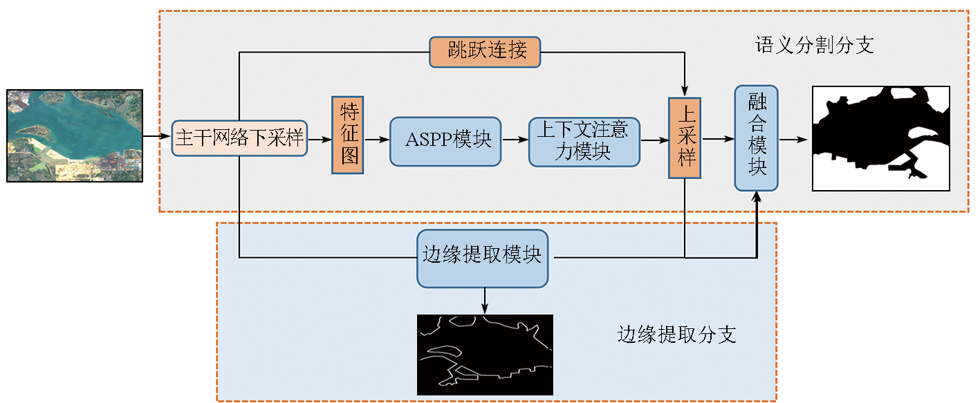
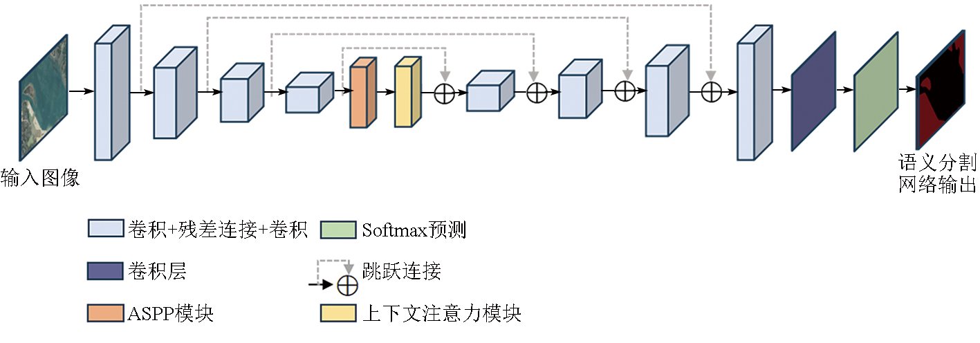
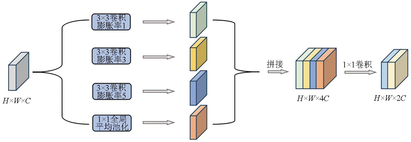
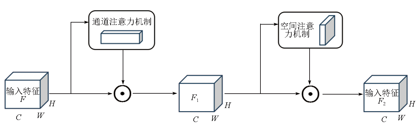
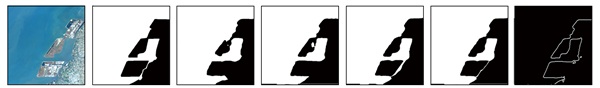
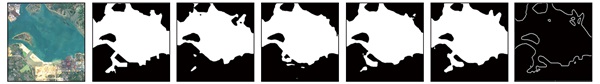
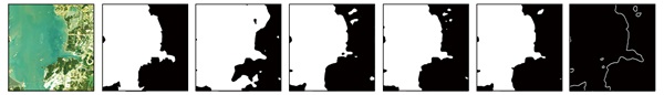
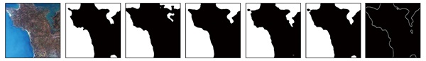
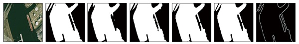
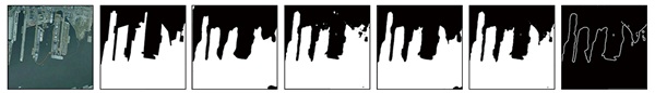
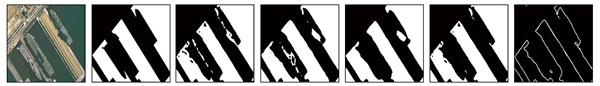
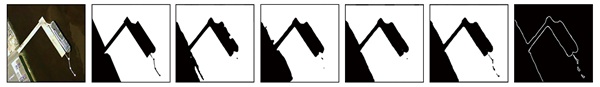
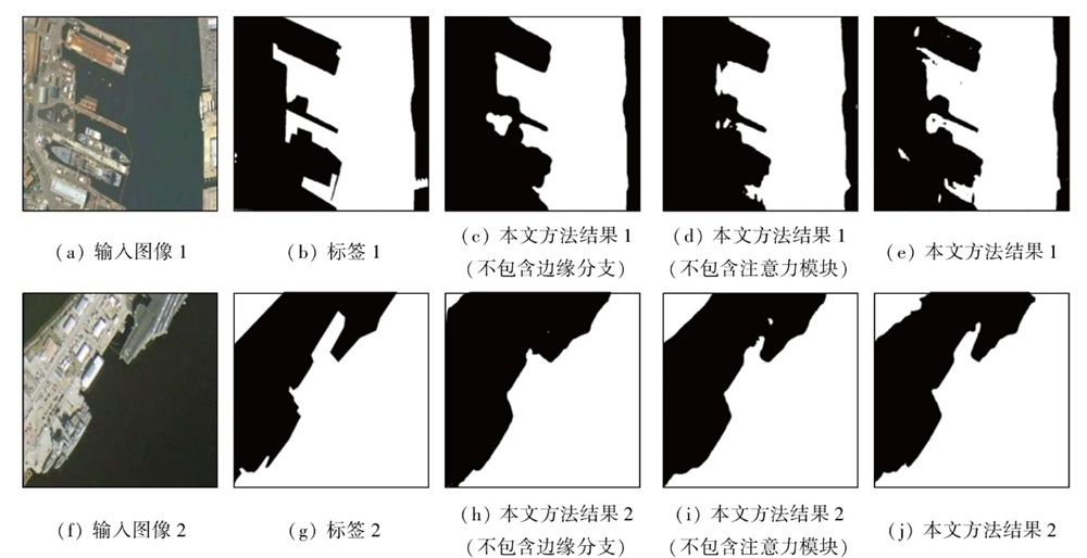
In optical remote sensing images with complex scenes and rich land cover information,the sea-land segmentation faces challenges such as low positioning accuracy and blurred edges. Therefore,this paper proposed a deep convolutional network model and a sea-land segmentation method that integrate contextual semantic information and edge features. First,the rich target semantic information was extracted from remote sensing images using the FusionNet semantic segmentation network module. Then,multi-scale and hierarchical contextual semantic features were extracted from the segmentation network using the enhanced atrous spatial pyramid pooling (ASPP) module and contextual attention module. Additionally,an edge extraction sub-network was built to extract multi-scale edge features. Finally,the semantic features and edge features were combined through a fusion module,thereby achieving accurate sea-land segmentation. This method was tested with two typical representative datasets. The results showed that this method achieved an overall prediction accuracy of 98.21%,an F1 score of 97.64%,and a boundary F1 score of 89.36%,all significantly outperforming other models. Particularly in complex backgrounds,this method can effectively improve the accuracy of segmentation and edge detection,demonstrating definite advantages in the segmentation of artificial coastlines and ports.
Liu G, Zhang Y S, Zheng X W, et al. A new method on inshore ship detection in high-resolution satellite images using shape and context information[J]. IEEE Geoscience and Remote Sensing Letters, 2014, 11(3):617-621.
[2]
Zhu C R, Zhou H, Wang R S, et al. A novel hierarchical method of ship detection from spaceborne optical image based on shape and texture features[J]. IEEE Transactions on Geoscience and Remote Sensing, 2010, 48(9):3446-3456.
[3]
Ji X, Tang L B, Lu T W, et al. DBENet:Dual-branch ensemble network for sea-land segmentation of remote-sensing images[J]. IEEE Transactions on Instrumentation and Measurement, 2023, 72:5503611.
Chen X, Sun J, Yin K Y, et al. Sea-land segmentation algorithm of SAR image based on Otsu method and statistical characteristic of sea area[J]. Journal of Data Acquisition and Processing, 2014, 29(4):603-608.
Li Y Q, Wang C Y, Sui Y, et al. Automatic extraction of the sea-land boundary from high spatial resolution images based on automatic threshold segmentation[J]. Remote Sensing Technology and Application, 2021, 36(6):1379-1387.
Liang X Y, Luo C, Quan J C, et al. Research on progress of image semantic segmentation based on deep learning[J]. Computer Engineering and Applications, 2020, 56(2):18-28.
doi: 10.3778/j.issn.1002-8331.1910-0300
Ma Y, Gulimila·K. Research review of image semantic segmentation method in high-resolution remote sensing image interpretation[J]. Journal of Frontiers of Computer Science and Technology, 2023, 17(7):1526-1548.
[8]
Lei S, Zou Z X, Liu D G, et al. Sea-land segmentation for infrared remote sensing images based on superpixels and multi-scale features[J]. Infrared Physics & Technology, 2018, 91:12-17.
[9]
Elkhateeb E, Soliman H, Atwan A, et al. A novel coarse-to-fine sea-land segmentation technique based on superpixel fuzzy C-means clustering and modified Chan-Vese model[J]. IEEE Access, 2021, 9:53902-53919.
[10]
Kalchbrenner N, Grefenstette E, Blunsom P. A convolutional neural network for modelling sentences[C]// Proceedings of the 52nd Annual Meeting of the Association for Computational Linguistics. Association for Computational Linguistics,2014:655-665.
[11]
Ronneberger O, Fischer P, Brox T. U-Net:Convolutional networks for biomedical image segmentation[C]//Medical Image Computing and Computer-Assisted Intervention-MICCAI 2015.Springer International Publishing,2015:234-241.
[12]
Badrinarayanan V, Kendall A, Cipolla R. SegNet:A deep convolutional encoder-decoder architecture for image segmentation[J]. IEEE Transactions on Pattern Analysis and Machine Intelligence, 2017, 39(12):2481-2495.
doi: 10.1109/TPAMI.2016.2644615
pmid: 28060704
[13]
Zhao H S, Shi J P, Qi X J, et al. Pyramid scene parsing network[C]//2017 IEEE Conference on Computer Vision and Pattern Recognition (CVPR). IEEE, 2017:6230-6239.
[14]
Wu X Y, Chen G, Ding X Q, et al. Multiscale deep fully convolutional network for sea-land segmentation of surveillance images[C]//2020 International Conference on Image,Video Processing and Artificial Intelligence. SPIE, 2020:29-35.
[15]
Ji X, Tang L B, Liu T H, et al. HeteroNet:A heterogeneous encoder-decoder network for sea-land segmentation of remote sensing im-ages[J]. Journal of Electronic Imaging, 2023, 32(5):053016.
[16]
Zhao L, Zhang Y S, Xue W, et al. Fast and accurate sea-land segmentation of SAR imagery based on multi-source data registration[J]. Geocarto International, 2022, 37(26):13748-13768.
[17]
Gao P, Tian J W. A novel model for edge aware sea-land segmentation[C]//MIPPR 2019: Remote Sensing Image Processing,Geographic Information Systems,and Other Applications. SPIE,2020:107-114.
Liang F, Zhang R X, Chai Y T, et al. A sea-land segmentation method for SAR images using context-aware and edge attention based CNNs[J]. Geomatics and Information Science of Wuhan University, 2023, 48(8):1286-1295.
[19]
Chen L, Papandreou G, Schroff F, et al. Rethinking atrous convolution for semantic image segmentation[J/OL]. arXiv, 2017(2017-06-17). http://arxiv.org/abs/1706.05587.
[20]
Quan T M, Hildebrand D G C, Jeong W K. FusionNet:A deep fully residual convolutional neural network for image segmentation in connectomics[J]. Frontiers in Computer Science, 2021, 3:613981.
[21]
He K M, Zhang X Y, Ren S Q, et al. Deep re-sidual learning for image recognition[C]//2016 IEEE Conference on Computer Vision and Pattern Recognition (CVPR). IEEE, 2016:770-778.
[22]
Woo S, Park J, Lee J Y, et al. CBAM:Convolutional block attention module[C]// Computer Vision-ECCV 2018.Springer International Publishing,2018:3-19.
[23]
Vaswani A, Shazeer N, Parmar N, et al. Attention is all you need[C]//31st Annual Conference on Neural Information Processing Systems (NIPS).ACM,2017:6000-6010.
Yang X Z, Zhou Y N, Zhang X, et al. Accurate extraction of artificial pit-pond integrating edge features and semantic information[J]. Journal of Geo-Information Science, 2022, 24(4):766-779.
[25]
Zhang Y, Liu F G, Tang Q. Utilize spatial prior in ground truth:Spatial-enhanced loss for semantic segmentation[C]// Artificial Neural Networks and Machine Learning-ICANN 2022.Springer Nature Switzerland,2022:312-321.
[26]
Li X Y, Sun X F, Meng Y X, et al. Dice loss for data-imbalanced NLP tasks[C]// Proceedings of the 58th Annual Meeting of the Association for Computational Linguistics. Association for Computational Linguistics,2020:465-476.
[27]
Salehi S S M, Erdogmus D, Gholipour A. Tversky loss function for image segmentation using 3D fully convolutional deep networks[C]// Machine Learning in Medical Imaging. Springer International Publishing,2017:379-387.
[28]
Lin T Y, Goyal P, Girshick R, et al. Focal loss for dense object detection[J]. IEEE Transactions on Pattern Analysis and Machine Intelligence, 2020, 42(2):318-327.
[29]
Kervadec H, Bouchtiba J, Desrosiers C, et al. Boundary loss for highly unbalanced segmentation[J]. Medical Image Analysis, 2021, 67:101851.
[30]
Yang T, Jiang S L, Hong Z H, et al. Sea-land segmentation using deep learning techniques for Landsat8 OLI imagery[J]. Marine Geodesy, 2020, 43(2):105-133.
[31]
Liu Z K, Yuan L, Weng L B, et al. A high resolution optical satellite image dataset for ship recognition and some new baselines[C]// Proceedings of the 6th International Conference on Pattern Recognition Applications and Methods. SciTePress,2017:324-331.
 2025, Vol. 37
  ), 普运伟1,2(