Estimating leaf area index of wheat at the booting stage using GF-2 data: A case study of Langfang City,Hebei Province
Kun LU1(), Qingyan MENG2(), Yunxiao SUN2,3, Zhenhui SUN2,3, Linlin ZHANG2,3
1.Geotramics College,Shandong University of Science and Technology,Qingdao 266590,China 2.Institute of Remote Sensing and Digital Earth,Chinese Academy of Sciences,Beijing 100101,China 3.University of Chinese Academy of Sciences,Beijing 100049,China
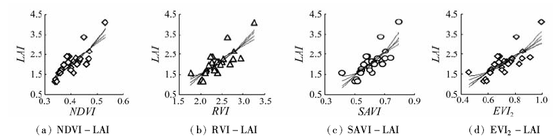
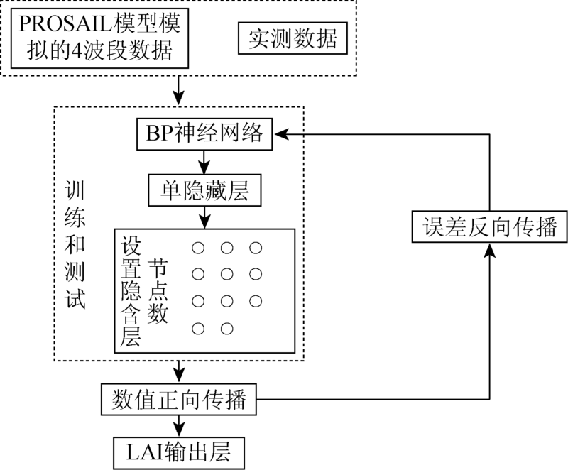
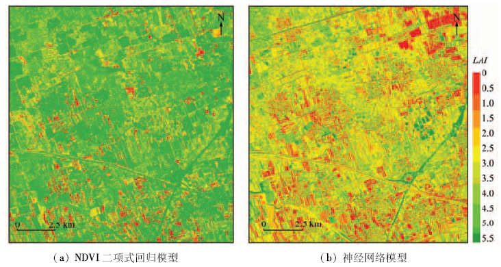
Leaf area index (LAI) is an important agricultural parameter to assess crop growing status for production estimation. Due to its very high spatial resolution, GF-2 can be used as a new source of remote sensing data for crop monitoring. It is particularly valuable to develop approaches for LAI estimation using GF-2 data. In this paper, the study of LAI estimation for wheat at the booting stage in Wanzhuang Town, Langfang City of Hebei Province in North China Plain is presented. Canopy LAI of wheat at the booting stage was measured over an experimental field in the town. Regression analysis method was performed with LAI and four different vegetation indexes, and the neural network method combined with the PROSAIL model was also considered. The results show that the best LAI retrieval regression model is the binomial model of normalized difference vegetation index (NDVI). The correlation coefficient (R2) and root mean square error (RMSE) are 0.719 3 and 0.393 6 respectively. Compared with the regression analysis method, the accuracy is greatly improved by using neural network method,and the R2 and RMSE reached 0.900 8 and 0.273 2 respectively. Neural network method has feasibility and applicability based GF-2 data at wheat booting stage, which would provide a reference scheme for LAI inversion from high spatial resolution satellite image.
陆坤, 孟庆岩, 孙云晓, 孙震辉, 张琳琳. 基于GF-2卫星数据的孕穗期小麦叶面积指数反演——以河北省廊坊市为例[J]. 国土资源遥感, 2018, 30(1): 196-202.
Kun LU, Qingyan MENG, Yunxiao SUN, Zhenhui SUN, Linlin ZHANG. Estimating leaf area index of wheat at the booting stage using GF-2 data: A case study of Langfang City,Hebei Province. Remote Sensing for Land & Resources, 2018, 30(1): 196-202.
Chen J M,Cihlar J.Retrieving leaf area index of boreal conifer forests using Landsat TM images[J].Remote Sensing of Environment,1996,55(2):153-162.
[2]
Pinty B,Lavergne T,Widlowski J L,et al.On the need to observe vegetation canopies in the near-infrared to estimate visible light absorption[J].Remote Sensing of Environment,2009,113(1):10-23.
Li X C,Xu X G,Bao Y S,et al.Retrieving LAI of winter wheat based on sensitive vegetation index by the segmentation method[J].Scientia Agricultura Sinica,2012,45(17):3486-3496.
[4]
Yang F,Sun J L,Fang H L,et al.Comparison of different methods for corn LAI estimation over northeastern China[J].International Journal of Applied Earth Observation and Geoinformation,2012,18:462-471.
Ren Z,Chen H L,Wang L X,et al.Research on inversion model of wheat LAI using cross-validation[J].Remote Sensing for Land and Resources,2015,27(4):34-40.doi:10.6046/gtzyyg.2015.04.06.
[6]
Meng Q Y,Wang C M,Gu X F,et al.Hot dark spot index method based on multi-angular remote sensing for leaf area index retrieval[J].Environmental Earth Sciences,2016,75:732.
Zhang Y,Meng Q Y,Wu J L,et al.Study of environmental vegetation index based on environment satellite CCD data and LAI inversion[J].Spectroscopy and Spectral Analysis,2011,31(10):2789-2793.
[8]
赵娟. 基于多时相多角度遥感数据的植被叶面积指数反演[D].南京:南京信息工程大学,2014.
Zhao J.Study of Leaf Area Index Inversion Based on Multi-Temporal and Multi-angular Remote Sensing Data[D].Nanjing:Nanjing University of Science and Technology,2014.
[9]
Kokaly R F,Clark R N.Spectroscopic determination of leaf biochemistry using band-depth analysis of absorption features and stepwise multiple linear regression[J].Remote Sensing of Environment,1999,67(3):267-287.
Song K S,Zhang B,Wang Z M,et al.Soybean LAI estimation with in-situ collected hyperspectral data based on BP-neural networks[J].Scientia Agricultura Sinica,2006,39(6):1138-1145.
Chen J,Ni S X,Li Y M.LAI retrieval of reed canopy using the neural network method[J].Remote Sensing for Land and Resources,2008,20(2):62-67.doi:10.6046/gtzyyg.2008.02.15.
Bao G,Qin Z H,Zhou Y,et al.The application of hyper-spectral data and RBF neural network method to retrieval of leaf area index of grassland[J].Remote Sensing for Land and Resources,2012,24(2):7-11.doi:10.6046/gtzyyg.2012.02.02.
[13]
Adler-Golden S M,Matthew M W,Bernstein L S,et al.Atmospheric correction for shortwave spectral imagery based on MODTRAN4[C]//Proceeding of the SPIE 3753,Imaging Spectrometry V.Denver,CO,United States:SPIE,1999,3753:61-69.
Hao J T,Yang W N,Li Y X,et al.Atmospheric correction of multi-spectral imagery ASTER[J]. Remote Sensing Information, 2008(1):78-81.
[15]
Gonsamo A,Pellikka P.The sensitivity based estimation of leaf area index from spectral vegetation indices[J].ISPRS Journal of Photogrammetry and Remote Sensing,2012,70:15-25.
[16]
Deering D W.Rangeland Reflectance Characteristics Measured by Aircraft and Spacecraft Sensors[D].College Station,Texas:Texas A and M University,1978:338.
[17]
Chen J M,Pavlic G,Brown L,et al.Derivation and validation of Canada-wide coarse-resolution leaf area index maps using high-resolution satellite imagery and ground measurements[J].Remote Sensing of Environment,2002,80(1):165-184.
[18]
Huete A R.A soil-adjusted vegetation index(SAVI)[J].Remote Sensing of Environment,1988,25(3):295-309.
[19]
Jiang Z Y,Huete A R,Didan K,et al.Development of a two-band enhanced vegetation index without a blue band[J].Remote Sensing of Environment,2008,112(10):3833-3845.
[20]
Baret F,Jacquemoud S,Guyot G,et al.Modeled analysis of the biophysical nature of spectral shifts and comparison with information content of broad bands[J].Remote Sensing of Environment,1992,41(2/3):133-142.
Gu C Y,Du H Q,Zhou G M,et al.Retrieval of leaf area index of Moso bamboo forest with Landsat Thematic Mapper image based on PROSAIL canopy radiative transfer model[J].Chinese Journal of Applied Ecology,2013,24(8):2248-2256.
Cai B F,Shao X.Leaf area index petrieval based on remotely sensed data and PROSPECT+SAIL model[J].Remote Sensing for Land and Resources,2007,19(2):39-43.doi:10.6046/gtzyyg.2007.02.10.
 2018, Vol. 30
  ), 孟庆岩2(