Urban land use classification based on remote sensing and multi-source geographic data
WU Linlin1,2(), LI Xiaoyan1(), MAO Dehua2, WANG Zongming2
1. College of Earth Sciences, Jilin University, Changchun 130012, China 2. Key Laboratory of Wetland Ecology and Environment, Northeast Institute of Geography and Agroecology, Chinese Academy of Sciences, Changchun 130102, China
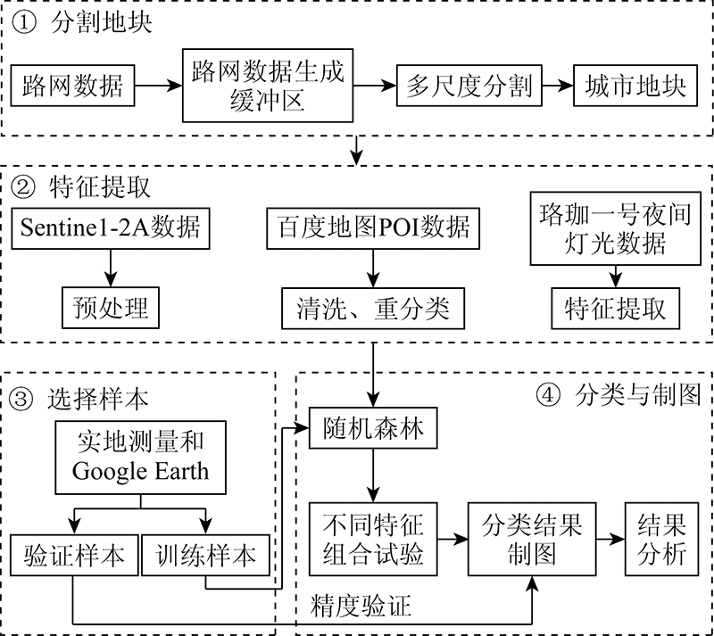
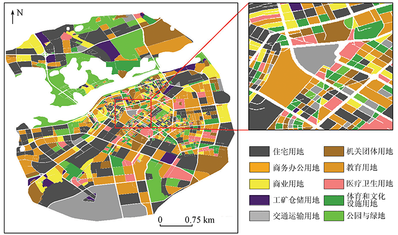
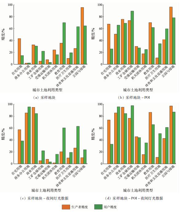
Urban land use (ULU) reflects urban functions and structures, and the study of ULU classification can provide guidance for the sustainable development of cities. This study conducted the ULU classification of the main urban area of Harbin City using the object-oriented and random forest methods by integrating multi-source geospatial data including Sentinel-2A remote sensing images, OpenStreetMap (OSM) data, point of interest (POI) data, and nighttime light data from the Luojia-1 satellite. The results are as follows. The overall accuracy of the first-level land use type was 86.0%, with a Kappa coefficient of 0.75. The overall accuracy of the second-level land use types was 73.9%, with a Kappa coefficient of 0.69. The introduction of POI data can significantly improve the classification accuracy of residential land, industrial and mining storage land, and educational land. Meanwhile, night light data can effectively improve the classification accuracy of commercial office land and business land. This study shows that the combination of remote sensing images with multi-source geographic data is effective for ULU classification.
吴琳琳, 李晓燕, 毛德华, 王宗明. 基于遥感和多源地理数据的城市土地利用分类[J]. 自然资源遥感, 2022, 34(1): 127-134.
WU Linlin, LI Xiaoyan, MAO Dehua, WANG Zongming. Urban land use classification based on remote sensing and multi-source geographic data. Remote Sensing for Natural Resources, 2022, 34(1): 127-134.
Ma Q, Gong Z, Kang J, et al. Measuring functional urban shrinkage with multi-source geospatial big data:A case study of the Beijing-Tianjin-Hebei megaregion[J]. Remote Sensing, 2020, 12(16):2513.
doi: 10.3390/rs12162513
[2]
Mao W, Lu D, Hou L, et al. Comparison of machine-learning metho-ds for urban land-use mapping in Hangzhou City,China[J]. Remote Sensing, 2020, 12(17):2817.
doi: 10.3390/rs12172817
[3]
Chang S, Wang Z, Mao D, et al. Mapping the essential urban land use in Changchun by applying random forest and multi-source geospatial data[J]. Remote Sensing, 2020, 12(15):2488.
doi: 10.3390/rs12152488
[4]
Zhang C, Sargent I, Pan X, et al. An object-based convolutional neural network (OCNN) for urban land use classification[J]. Remote Sensing of Environment, 2018, 216:57-70.
doi: 10.1016/j.rse.2018.06.034
[5]
Zhang C, Sargent I, Pan X, et al. Joint deep learning for land cover and land use classification[J]. Remote Sensing of Environment, 2019, 221:173-187.
doi: 10.1016/j.rse.2018.11.014
[6]
Hu T, Yang J, Li X. et al. Mapping urban land use by using Landsat images and open social data[J]. Remote Sensing, 2016, 8(2):151.
doi: 10.3390/rs8020151
[7]
Su M, Guo R, Chen B, et al. Sampling strategy for detailed urban land use classification:A systematic analysis in Shenzhen[J]. Remote Sensing, 2020, 12(9):1497.
doi: 10.3390/rs12091497
[8]
Sun J, Wang H, Song Z, et al. Mapping essential urban land use categories in Nanjing by integrating multi-source big data[J]. Remote Sensing, 2020, 12(15):2386.
doi: 10.3390/rs12152386
[9]
He S, Chen X, Zhang Z, et al. The exploration of urban material anabolism based on RS and GIS methods:A case study in Jinchang,China[J]. Remote Sensing, 2020, 12(3):370.
doi: 10.3390/rs12030370
[10]
Wang R, Hou H, Murayama Y, et al. Spatiotemporal analysis of land use/cover patterns and their relationship with land surface temperature in Nanjing,China[J]. Remote Sensing, 2020, 12(3):440.
doi: 10.3390/rs12030440
[11]
Gong P, Chen B, Li X. Mapping essential urban land use categories in China (EULUC-China):Preliminary results for 2018[J]. Science Bulletin, 2020, 65(3):182-187.
doi: 10.1016/j.scib.2019.12.007
[12]
Zong L, He S, Lian J, et al. Detailed mapping of urban land use based on multi-source data:A case study of Lanzhou[J]. Remote Sensing, 2020, 12(12):1987.
doi: 10.3390/rs12121987
[13]
Zeferino L B, Souza L F T D, Amaral C H D, et al. Does environmental data increase the accuracy of land use and land cover classification?[J]. International Journal of Applied Earth Observation and Geoinformation, 2020, 91:102-128.
[14]
Saboori M, Asghar T A, Reza R B H. Combining multi-scale textural features from the panchromatic bands of high spatial resolution images with ANN and MLC classification algorithms to extract urban land uses[J]. International Journal of Remote Sensing, 2019, 40(22):8608-8634.
doi: 10.1080/01431161.2019.1620371
[15]
Tu Y, Chen B, Zhang T, et al. Regional mapping of essential urban land use categories in China:A segmentation-based approach[J]. Remote Sensing, 2020, 12(7):1058.
doi: 10.3390/rs12071058
[16]
Zhang Y, Qin K, Bi Q, et al. Landscape patterns and building functions for urban land-use classification from remote sensing images at the block level:A case study of Wuchang district,Wuhan,China[J]. Remote Sensing, 2020, 12(11):1831.
doi: 10.3390/rs12111831
Zhou T N, Ming D P, Zhao R. Land cover classification based on parameter optimization random forest algorithm[J]. Science of Surveying and Mapping, 2017, 42(2):88-94.
Ma Y, Jiang Q G, Meng Z G. Research on land use classification of farming areas based on random forest algorithm[J]. Transactions of the Chinese Society of Agricultural Machinery, 2016, 47(1):297-303.
Yang Y, Xu L, Yan P L. Urban land use/cover remote sensing classification based on random forest under conditional random field framework[J]. Remote Sensing for Land and Resources, 2014, 26(4):51-55.doi: 10.6046/gtzyyg.2014.04.09.
doi: 10.6046/gtzyyg.2014.04.09
Xue B, Xiao X, Li J Z. Spatial structure analysis of northeast cities based on big data of point of interest (POI)[J]. Geographical Sciences, 2020, 40(5):691-700.
Li X. Urban multi-center structure recognition based on the spatial aggregation characteristics of POI elements:Taking Zhengzhou as an example[J]. Acta Scientiarum Naturalium Universitatis Pekinensis, 2020, 56(4):692-702.
[22]
Brovelli M, Zamboni G. A new method for the assessment of spatial accuracy and completeness of OpenStreetMap building footprints[J]. ISPRS International Journal of Geo-Information, 2018, 7(8):289.
doi: 10.3390/ijgi7080289
Zheng J L. Research and application of data cleaning in the construction of POI data warehouse[D]. Beijing:China University of Mining and Technology(Beijing),2016.
Chen Y B, Zheng Z H, Wu Z F, et al. Summary and prospect of the application of nighttime light remote sensing data[J]. Progress in Geography, 2019, 38(2):205-223.
Li Q X, Zheng H, Zhang G, et al. Analysis of Luojia-1 index based on nighttime light image[J]. Geoinformation of Surveying and Mapping, 2020, 45(3):8-15.
Lin X C, Li Y S. Research on the segmentation scale of high-resolution remote sensing image of Chengdu Plain[J]. Remote Sensing for Land and Resources, 2010, 22(2):7-11.doi: 10.6046/gtzyyg.2010.02.02.
doi: 10.6046/gtzyyg.2010.02.02
Wang L, Liu Q Y. A review of optimal scale selection methods in multi-scale segmentation of high-resolution remote sensing images[J]. Surveying and Spatial Information, 2015, 38(3):166-169.
Huang H H, Huang W L. Urban land type extraction based on object-oriented classification method[J]. Journal of Fujian Normal University (Natural Science Edition), 2014, 30(6):96-102.
[29]
Woodcock C, Eand Strahler A H. The factor of scale in remote sensing[J]. Remote Sensing of Environment, 1987, 21(3):311-332.
doi: 10.1016/0034-4257(87)90015-0
Li Z, Yang X M, Meng F, et al. Random forest macro-scale land cover classification method aided by phenological characteristics[J]. Remote Sensing Information, 2013, 28(6):48-55.
 2022, Vol. 34
  ), 李晓燕1(