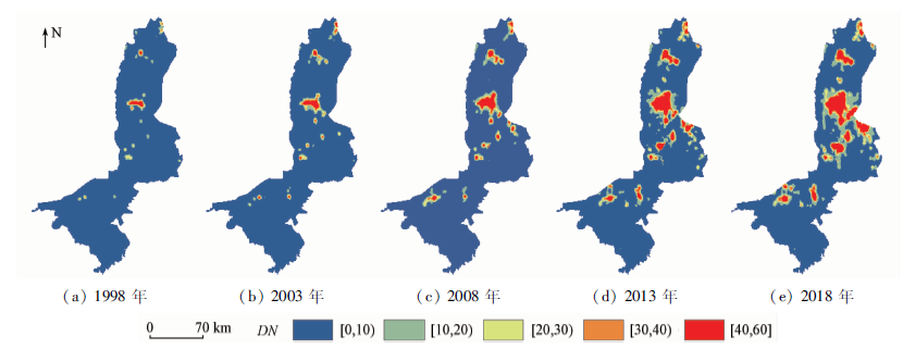
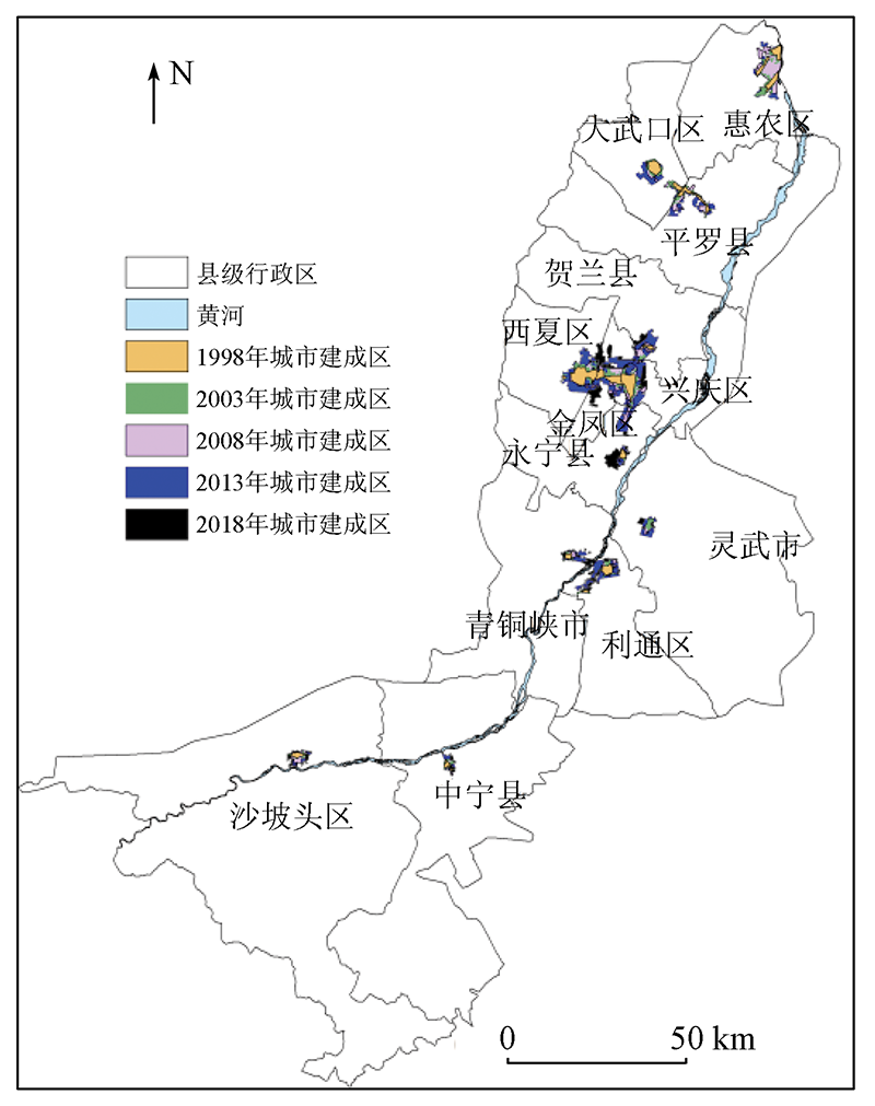
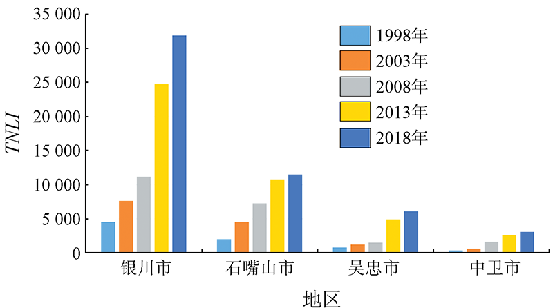
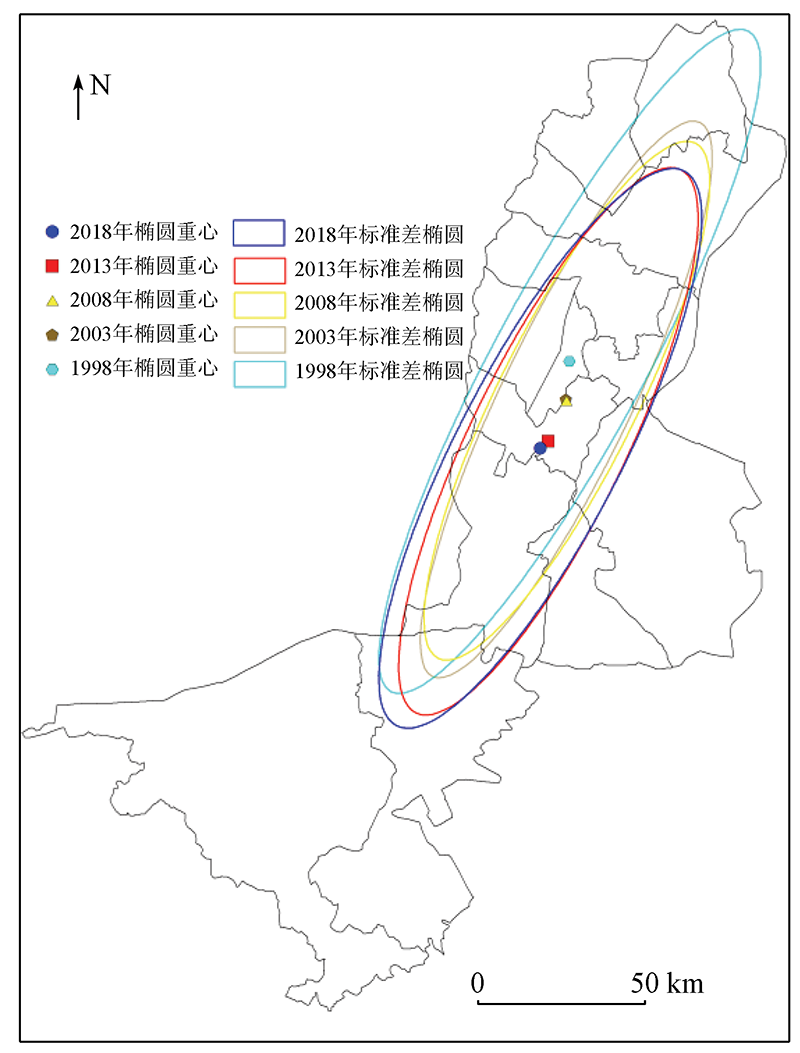
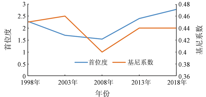
This study analyzed the spatio-temporal evolutionary characteristics of the Ningxia urban agglomeration along the Yellow River during 1998—2018 from the aspects of morphology, scale, and structure. To this end, the urban built-up area in the study area during the 20 years was extracted from five stages of DMSP/OLS and NPP/VIIRS nighttime light data using a high-resolution data comparison method. The results are as follows: ①The Ningxia urban agglomeration along the Yellow River expanded rapidly during 1998—2018, and the increment and growth rate peaked during 2008—2013. ②The constantly decreased fragmentation degree indicates that the inner morphology of the urban agglomeration became increasingly compact and the built-up patches were relatively concentrated. The fractal dimension continuously decreased, and the geometric shape of the urban agglomeration tended to be regular. Moreover, the urban agglomeration mainly expanded in the means of internal filling. ③The center of the urban agglomeration migrated to the southwest and approached its geometric center, and the urban development accelerated in the south. ④The primacy ratio and Gini coefficient of the urban agglomeration first decreased and then increased, indicating that the gap between cities in the urban agglomeration first narrowed and then widened.
布自强, 白林波, 张佳瑜. 基于夜光遥感的宁夏沿黄城市群时空演变[J]. 自然资源遥感, 2022, 34(1): 169-176.
BU Ziqiang, BAI Linbo, ZHANG Jiayu. Spatio-temporal evolution of Ningxia urban agglomeration along the Yellow River based on nighttime light remote sensing. Remote Sensing for Natural Resources, 2022, 34(1): 169-176.
Yu B L, Wang C X, Gong W K, et al. Nighttime light remote sensing and urban studies: Data,methods,applications,and prospects[J]. National Remote Sensing Bulletin, 2021, 25(1):342-364.
Lu C Y, Xu Y T, Lin X Q, et al. Study of spatio-temporal evolution of the circum-Bohai urban agglomeration based on DMSP/OLS nightime light data[J]. Remote Sensing for Land and Resources, 2019, 31(4):218-226.doi: 10.6046 /gtzyyg.2019.04.28.
doi: 10.6046 /gtzyyg.2019.04.28
Li G H, Fan J F, et al.Zhou Y K. Development characteristics estimation of Shandong peninsula urban agglomeration using VIIRS night light data[J]. Remote Sensing Technology and Application, 2020, 35(6):1348-1359.
Li D R, Yu H R, Li X. The spatial-temporal pattern analysis of city development in countries along the Belt and Road Initiative based on nighttime light data[J]. Geomatics and Information Science of Wuhan University, 2017, 42(6):711-720.
[5]
Li X, Li D R, Xu H M, et al. Intercalibration between DMSP/OLS and VIIRS night-time light images to evaluate city light dynamics of Syria’s major human settlement during Syrian civil war[J]. International Journal of Remote Sensing, 2017, 38(21):5934-5951.
doi: 10.1080/01431161.2017.1331476
[6]
Peng J, Lin H X, Chen Y Q, et al. Spatiotemporal evolution of urban agglomerations in China during 2000—2012:A nighttime light approach[J]. Landscape Ecology, 2020, 35(2):421-434.
doi: 10.1007/s10980-019-00956-y
Wang C L, Zhu Z L, Wang M M, et al. Evaluation of coordinated development of settlement environment and economy in economic zone along the Yellow River in Ningxia[J]. Research of Soil and Water Conservation, 2014, 21(2):189-193.
Cao Z Y, Wu Z F, Mi S J, et al. A method for classified correction of stable DMSP/OLS nighttime light imagery across China[J]. Acta Geoinformatics Sinica, 2020, 22(2):246-257.
Wang X H, Xiao P F, Feng X Z, et al. Extraction of large-scale urban area information in China using DMSP/OLS nighttime light data[J]. Remote Sensing for Land and Resources, 2013, 25(3):159-164.doi: 10.6046 /gtzyyg.2013.03.26.
doi: 10.6046 /gtzyyg.2013.03.26
[12]
Henderson M, Yeh E T, Gong P, et al. Validation of urban boundaries derived from global night-time satellite imagery[J]. International Journal of Remote Sensing, 2003, 24(3) :595-609.
doi: 10.1080/01431160304982
Gao N, Ge Y C, Song X Y. Study of urban expansion and driving factors in Xi’an City based on nighttime light data[J]. Remote Sensing Technology and Application, 2019, 34(1):207-215.
Zhang W B, Zhang Z B, Zhou Y, et al. Temporal-spatial evolution characteristics of Lanxi urban agglomeration based on night light data[J]. Remote Sensing Information, 2020, 35(6):38-43.
Zhang J Y, Bai L B, Yang M L. Spatial and temporal evolution of Yinchuan urban expansion in the last 30 years[J]. Soil and Water Conservation Research, 2019, 26(5):359-365.
Li X M, Yan P, Liu B L. Spatial distribution characteristics of sandy land in northern China based on watershed scale landscape pattern characteristics of aeolian-fluvial interactions at the scale of watersheds in Northern China[J]. Journal of Arid Land Resources and Environment, 2021, 35(4):104-111.
Gu H Y, Shen T Y. Spatial evolution characteristics and driving forces of Chinese highly educated talents[J]. Acta Geographica Sinica, 2021, 76(2):326-340.
[19]
Allison P D. Measures of inequality[J]. American Sociological Review, 1978, 43(6):865-880.
doi: 10.2307/2094626
[20]
周瑞瑞. 宁夏沿黄城市群城镇化质量及时空格局演变特征研究[D]. 银川:宁夏大学, 2017.
Zhou R R. A study on quality of urbanization and evolution of spatial-temporal patterns of urbanization on the city zone along the Yellow River in Ningxia[D]. Yingchuan: Ningxia University, 2017.
 2022, Vol. 34
  ), 白林波, 张佳瑜(