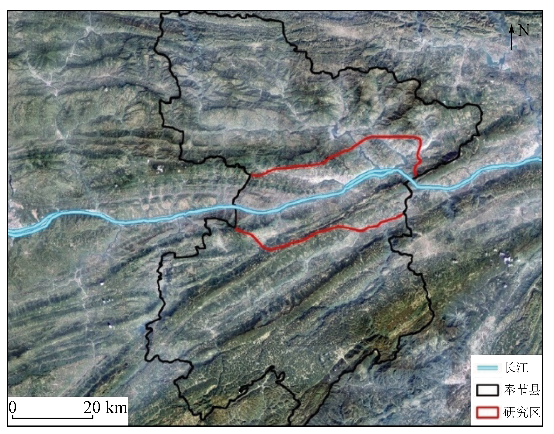
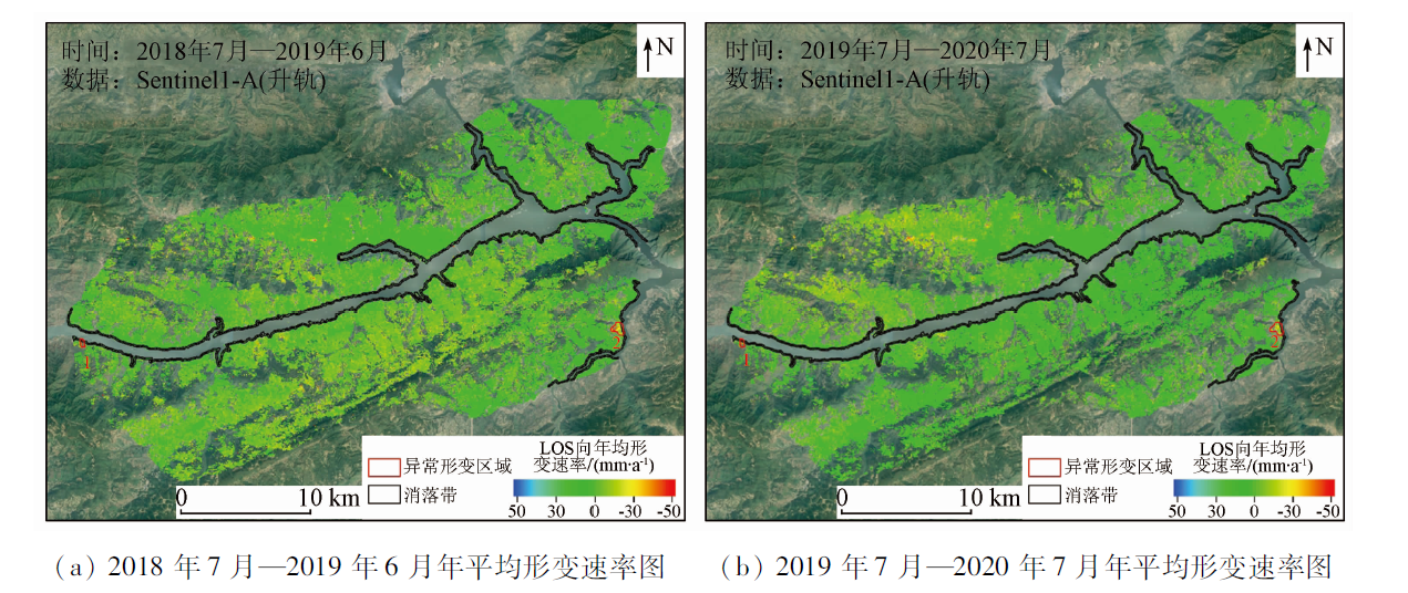
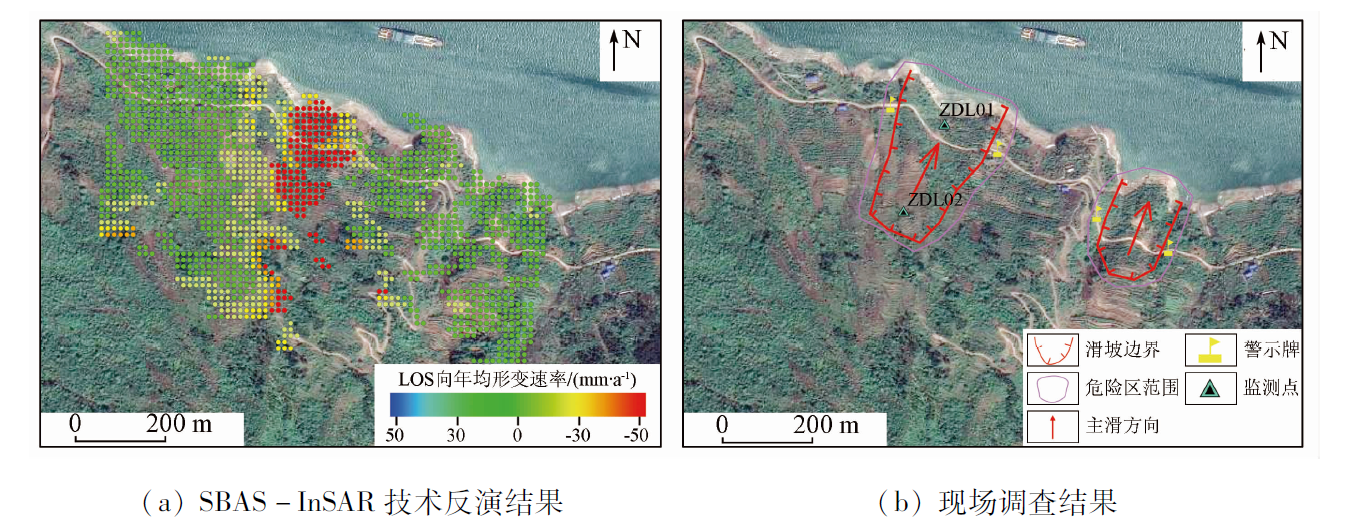
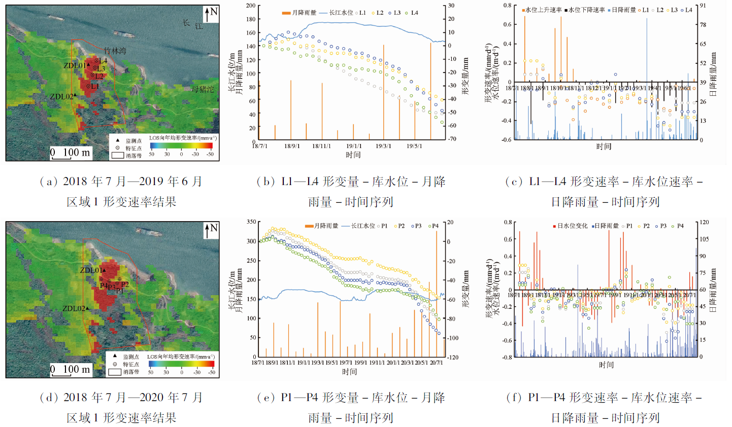
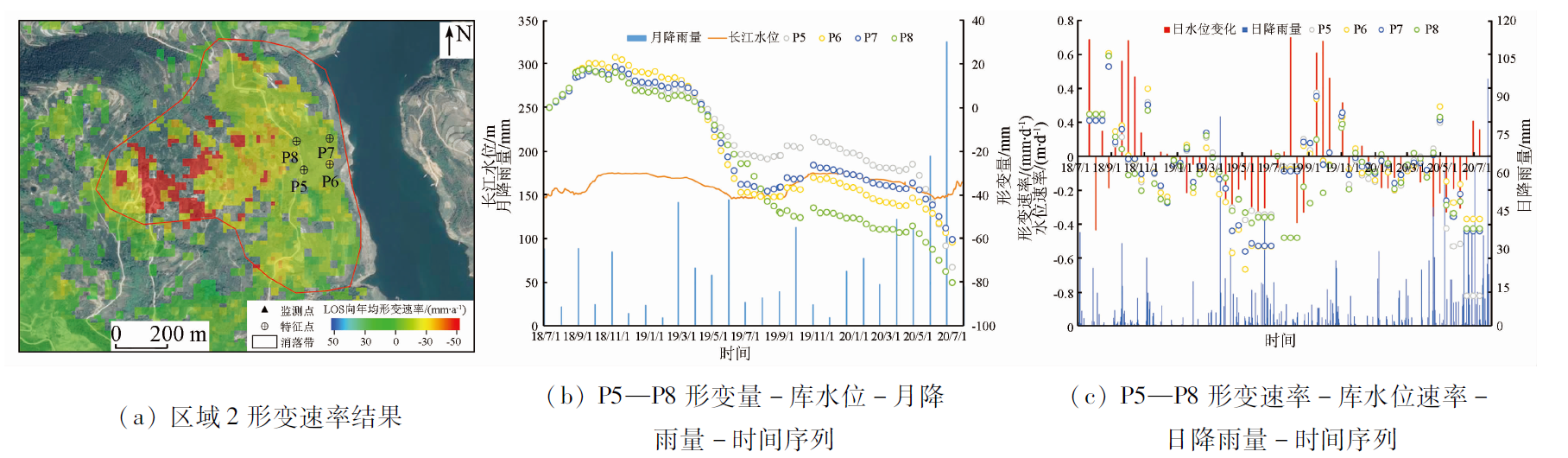
Hydro-fluctuation belts are frequently struck by geological disasters. Therefore, ascertaining the effects of hydrological factors such as reservoir water level and rainfall on the surface deformation of these belts is of great significance for the early warning, prevention, and control of geological disasters. Based on 63 scenes of Sentinel-1 ascending images of the Fengjie section of the Three Gorges Reservoir Area from July 2018 to July 2020, this study conducted the inversion of surface deformation using the small baseline subset interferometric synthetic aperture Radar (SBAS-InSAR) technique. The inversion results were compared with the data of ground monitoring points, and the hydrological elements were analyzed using the time series diagrams of deformation, reservoir water level, and monthly rainfall. The conclusions are as follows: ① The change in the reservoir water level and rainfall are important factors causing surface deformation. The effects of the change in the reservoir water level on the slope are primarily reflected in the buoyancy effect and the water level difference inside and outside the slope. In comparison, rainfall can decrease the shear strength and increase the dead weight of the slope, thus further increasing the deformations; ② Quicker change in the reservoir water level corresponds to larger surface deformation, and vice versa; ③ Rainfall is directly proportional to surface deformation and totally dominates the surface deformation in the case of extremely heavy precipitation; ④ The surface of the study area is stable overall. However, two deformation anomaly zones have been found near the hydro-fluctuation belt. They have annual deformation rates of over 30 mm/a, with a maximum of up to 89 mm/a within the anomaly zones. The above conclusions have high theoretical and practical values and can provide scientific support for the accurate prevention and control of geological disasters in hydro-fluctuation belts.
潘建平, 付占宝, 邓福江, 蔡卓言, 赵瑞淇, 崔伟. 时序InSAR解析消落带区域岸坡地表形变及其水要素影响[J]. 自然资源遥感, 2023, 35(2): 212-219.
PAN Jianping, FU Zhanbao, DENG Fujiang, CAI Zhuoyan, ZHAO Ruiqi, CUI Wei. A time-series InSAR-based analysis of surface deformation of hydro-fluctuation belts and the effects of hydrological elements. Remote Sensing for Natural Resources, 2023, 35(2): 212-219.
Huang B L, Yin Y P, Zhang Z H, et al. Study on deterioration characteristics of shallow rock mass in water the level fluctuation zone of karst bank slopes in Three Gorges Reservoir area[J]. Chinese Journal of Rock Mechanics and Engineering, 2019, 38(9):1786-1796.
Yang H, Tang M G, Xu Q, et al. Deterioration characteristic test and quality evaluation of bank slope rock mass in hydro-fluctuation belt of Three Gorges Reservoir area[J]. Journal of Hydraulic Engineering, 2020, 51(11):1360-1371.
Shen Z F, Zhang K J, Xia X, et al. Bibliometric analysis of the current situation and hot research topics on the water level fluctuation zone of Three Gorges Reservoir[J]. Journal of Hydroecology, 2021, 42(1):26-34.
Gao L. Terrain change and geological hazard analysis of the hydro-fluctuation belt in the Wushan of Three Gorges Reservoir area[D]. Beijing: China University of Geosciences (Beijing), 2018.
[6]
王丰. 奉节消落带岸坡稳定性评价[D]. 北京: 中国地质大学(北京), 2019.
Wang F. Stability evaluation of bank slopes in Fengjie[D]. Beijing: China University of Geosciences (Beijing), 2019.
Zhou J, Deng M L, Li Z J, et al. Response patterns of buoyancy weight loss landslides under reservoir water level fluctuation in the Three Gorges Rservoir area[J]. Hydrogeology & Engineering Geology, 2019, 46(5):136-143.
Fu X L, Tang M G, Ye R Q, et al. Study on deformation and stability of hydrodynamic landslide under different reservoir water fluctuation modes[J]. Water Resources and Hydropower Engineering, 2021, 52(1):201-211.
[9]
Andrew K G, Richard M G, Howard A Z. Mapping small elevation changes over large areas:Differential Radar interferometry[J]. Journal of Geophysical Research Solid Earth, 1989, 94(B7):9183-9191.
[10]
Berardino P, Fornaro G, Lanari R, et al. A new algorithm for surface deformation monitoring based on small baseline differential SAR Interferograms[J]. IEEE Transactions on Geoscience and Remote Sensing, 2002, 40(11):2375-2383.
doi: 10.1109/TGRS.2002.803792
Jiang Z Y. Study on the solving methods of the ill-posed problems of the SBAS InSAR deformation model[J]. Acta Geodaetica et Cartographica Sinica, 2020, 49(3):399.
doi: 10.11947/j.AGCS.2020.20190075
[12]
海香. 重庆市奉节县地质灾害风险评价及防灾减灾措施[D]. 重庆: 西南大学, 2008.
Hai X. A study on risk assessment about geological disasters and hazard prevention and mitigation measures of Fengjie in Chongqing[D]. Chongqing: Southwest University, 2008.
[13]
马新建. 三峡库区滑坡堆积体的渗透特性及渗流规律研究[D]. 成都: 成都理工大学, 2018.
Ma X J. The study of the permeability characteristics and seepage law of landslide accumulation body in the Three Gorges Reservoir area[D]. Chengdu: Chengdu University of Technology, 2018.
Xu J H, Sun D L, Wang Y, et al. Landslide susceptibility mapping of Fengjie County based on GIS and improved analytic hierarchy process[J]. Journal of Chongqing Normal University(Natural Science), 2020, 37(2):36-44,2,142.
Wu J F, Luo Y H, Zhou L L. Study of buoyancy effect on stability of Zhulinwan landslide in Three Gorges Reservoir area[J]. Journal of China Three Gorges University(Natural Sciences), 2019, 41(6):48-53.
Li Y K, Xu Q, Dong Y F, et al. Influence of reservoir water level fluctuation on typical hydrodynamic pressure landslide:Taking Baijiabao landslide in Three Gorges Reservoir for an example[J]. Science Technology and Engineering, 2017, 17(18):18-24.
Huang G W, Wang J X, Du Y, et al. Time-delay analysis and prediction of landslide considering precipitation and reservoir water level:A case study of Xinpu landslide in Three Gorges Reservoir area[J]. Journal of Earth Sciences and Environment, 2021, 43(3):621-631.
Yan Y Q, Guo C B, Zhang Y S, et al. Study on the deformation characteristics of Xiongba ancient landslide based on SBAS-InSAR method,Tibet[J]. Acta Geologica Sinica, 2021, 95(11):3556-3570.
Zhu T T, Shi X G, Zhou C, et al. Stability monitoring and analysis of Shupinglandslide in Three Gorges Area with Sentinel-1 images from 2016 to 2020[J]. Geomatics and Information Science of Wuhan University, 2021, 46(10):1560-1568.
Wang S X, Li S Y, Niu R Q. Monitoring slope displacements of Muyubao landslide using InSAR analysis technique[J]. Journal of Yangtze River Scientific Research Institute, 2022, 39(4):77-84.
 2023, Vol. 35
  ), 付占宝(