A random forest-based method integrating indices and principal components for classifying remote sensing images
LIANG Jintao1(), CHEN Chao2(), ZHANG Zili3, LIU Zhisong4
1. Marine Science and Technology College, Zhejiang Ocean University, Zhoushan 316022, China 2. School of Geography Science and Geomatics Engineering, Suzhou University of Science and Technology, Suzhou 215009, China 3. Zhejiang Ecological and Environmental Monitoring Center (Zhejiang Key Laboratory of Ecological and Environmental Monitoring, Forewarning and Quality Control), Hangzhou 310012, China 4. School of Information Engineering, Zhejiang Ocean University, Zhoushan 316022, China
Accurate information about land use/land cover (LULC) can provide significant guidance for regional spatial planning and sustainable development. However, conventional methods for remote sensing image classification are challenging due to complex surface morphologies, diverse surface feature types, and nonlinear features of remote sensing images. Therefore, they fail to fully utilize the rich information in remote sensing images. This study developed a random forest-based classification method for remote sensing images to extract LULC information by integrating indices and principal components. First, the images covering the study area were selected to determine cloud cover and conduct median synthesis of images, obtaining interannual remote sensing images. Then, various calculated indices and the extracted principal components were integrated into the band stacks of remote sensing images. Furthermore, classifiers were constructed using different machine-learning algorithms. Finally, based on a confusion matrix, the classification results were evaluated using overall accuracy and the Kappa coefficient. The experimental results of the Hangzhouwan area show that the decision support based on vegetation, water, building indices, and principal components can improve the classification accuracy, yielding overall accuracy and Kappa coefficient of 91.42% and 0.894 2, respectively, which were higher than those of conventional methods such as random forest, classification and regression tree, and support vector machine. The method for remote sensing image classification proposed in this study, which integrates indices and principal components, can obtain high-accuracy land use classification results by accurately extracting land cover features in remote sensing images. This study will provide method support for fine-scale surface classification.
梁锦涛, 陈超, 张自力, 刘志松. 一种融合指数与主成分分量的随机森林遥感图像分类方法[J]. 自然资源遥感, 2023, 35(3): 35-42.
LIANG Jintao, CHEN Chao, ZHANG Zili, LIU Zhisong. A random forest-based method integrating indices and principal components for classifying remote sensing images. Remote Sensing for Natural Resources, 2023, 35(3): 35-42.
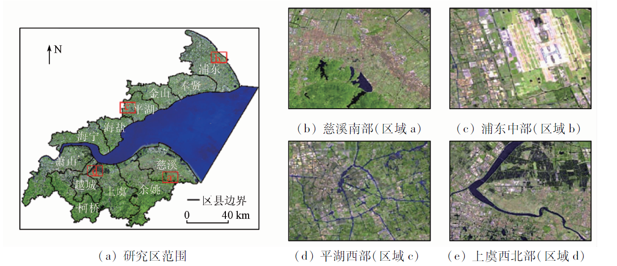
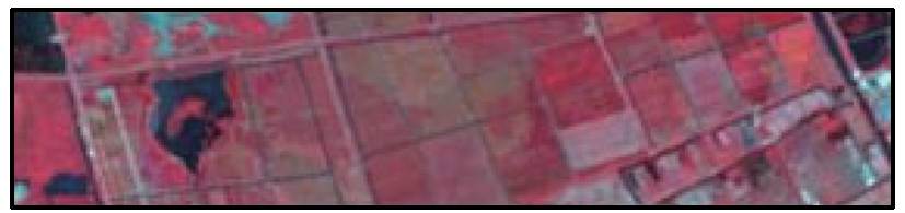
Fig.1 研究区以及局部对比区域 (Landsat8 OLI B7(R),B6(G),B4(B)彩色合成)
Fig.2 研究流程
类别
定义
样本 点/个
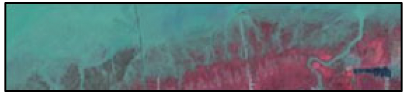
遥感图像特征 (标准假彩色合成)
建设用地
城乡居民点及工矿交通等用地
210
林地
树木、灌木和其他林地
220
水体
自然陆地水域、水利设施用地和养殖池塘
130
耕地
长年可正常耕作的农田
250
裸地
地表为土壤或岩石,土地基本不被植被覆盖
100
滩涂
海高低潮位之间的潮汐淹没区
100
Tab.1 分类方案、样本点及图像特征
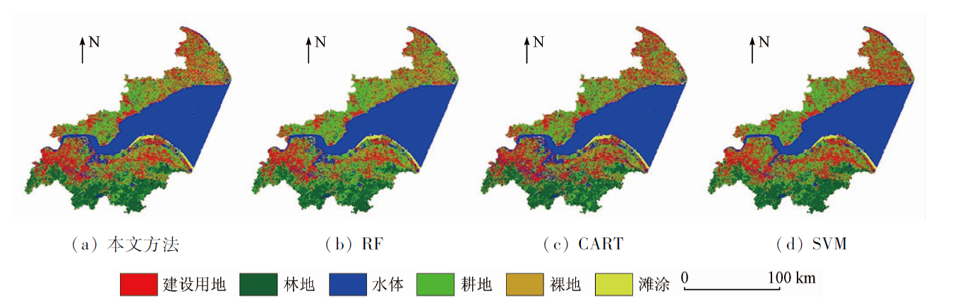
Fig.3 4种方法分类结果
类别
本文方法
RF
CART
SVM
OA/%
91.42
88.78
83.17
77.23
Kappa系数
0.894 2
0.861 5
0.792 6
0.716 1
Tab.2 4种机器学习算法分类精度对比
类别
建设用地
林地
水体
耕地
裸地
滩涂
ESA
2 851.35
2 884.21
605.99
3 812.34
1 274.23
141.40
本文方法
2 984.76
1 881.52
680.21
4 800.59
1 078.13
161.50
RF
2 545.11
1 776.72
675.00
5 398.44
1 029.98
166.13
CART
2 964.11
1 803.62
1 216.39
4 594.25
848.88
174.46
SVM
3 507.76
1 939.85
438.10
5 539.48
1.68
163.52
Tab.3 4种分类方法各类别面积统计
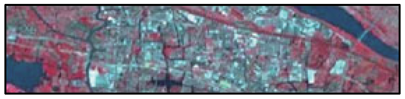
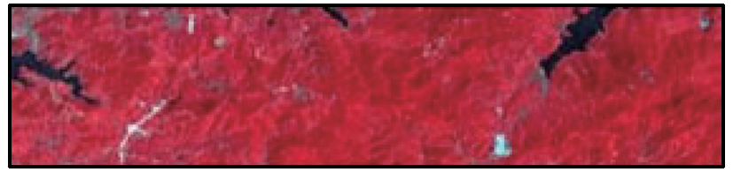
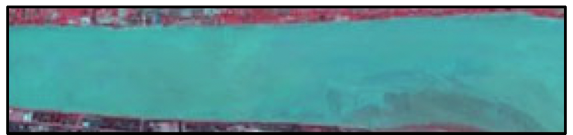
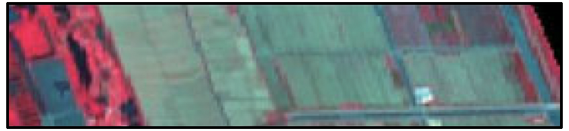
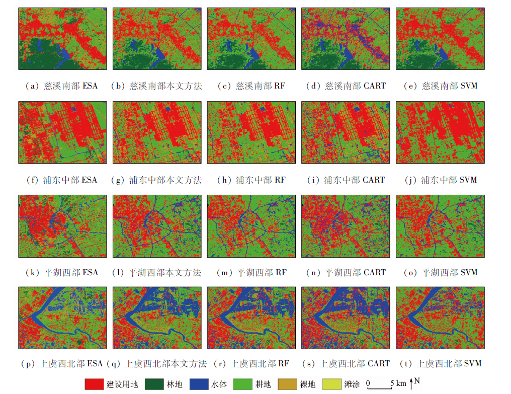
Fig.4 局部区域分类结果对比
[1]
Rawat J S, Kumar M. Monitoring land use/cover change using remote sensing and GIS techniques:A case study of Hawalbagh Block,District Almora,Uttarakhand,India[J]. The Egyptian Journal of Remote Sensing and Space Science, 2015, 18(1):77-84.
doi: 10.1016/j.ejrs.2015.02.002
[2]
Yao J, Wu J, Xiao C, et al. The classification method study of crops remote sensing with deep learning,machine learning,and Google Earth Engine[J]. Remote Sensing, 2022, 14(12):2758.
doi: 10.3390/rs14122758
Yang Y, Xu L, Yan P L. Urban land use/cover remote sensing classification based on random forest under conditional random field framework[J]. Remote Sensing for Land and Resources, 2014, 26(4):51-55.doi:10.6046/gtzyyg.2014.04.09.
doi: 10.6046/gtzyyg.2014.04.09
Xiong H, Liu Y L, Che S S, et al. Simulation model of land use change based on support vector machine[J]. Geomatics and Information Science of Wuhan University, 2009, 34(3):366-369.
Yang X G, Huang H J, Yan L W, et al. Research on island land use classification based on decision tree method[J]. Remote Sensing for Land and Resources, 2012, 24(2):116-120.doi:10.6046/gtzyyg.2012.02.21.
doi: 10.6046/gtzyyg.2012.02.21
[6]
Bangira T, Alfieri S M, Menenti M, et al. Comparing thresholding with machine learning classifiers for mapping complex water[J]. Remote Sensing, 2019, 11(11):1351.
doi: 10.3390/rs11111351
[7]
Wu H, Lin A, Xing X, et al. Identifying core driving factors of urban land use change from global land cover products and POI data using the random forest method[J]. International Journal of Applied Earth Observation and Geoinformation, 2021, 103:102475.
doi: 10.1016/j.jag.2021.102475
[8]
Rodriguez-Galiano V F, Ghimire B, Rogan J, et al. An assessment of the effectiveness of a random forest classifier for land-cover classification[J]. ISPRS Journal of Photogrammetry and Remote Sensing, 2012, 67:93-104.
doi: 10.1016/j.isprsjprs.2011.11.002
Wu F Y, Wang X, Ding J W, et al. Hyperspectral remote sensing image classification based on improved multi-cascade random forest network[J]. Journal of Remote Sensing, 2020, 24(4):439-453.
[10]
Ge G, Shi Z, Zhu Y, et al. Land use/cover classification in an arid desert-oasis mosaic landscape of China using remote sensed imagery:Performance assessment of four machine learning algorithms[J]. Global Ecology and Conservation, 2020, 22:e00971.
doi: 10.1016/j.gecco.2020.e00971
Xiao X W, Shen X Y, Ke C Q, et al. Comparison of multiple machine learning algorithms based on Sentinel-1A data to identify icebergs[J]. Acta Geodaetica et Cartographica Sinica, 2020, 49(4):509-521.
Dong J, Ren G B, Hu Y B, et al. Construction and classification of coral reef geomorphological unit system based on high-resolution remote sensing: Taking 8-band Worldview-2 image as an example[J]. Journal of Tropical Oceanography, 2020, 39(4):116-129.
Jia M M, Liu D W, Wang Z M, et al. Coastline extraction and analysis of Hangzhou Bay based on object-oriented method and multi-source remote sensing data[J]. Journal of Geo-Information Science, 2013, 15(2):262-269.
doi: 10.3724/SP.J.1047.2013.001262
[14]
Li D, Lu D, Wu M, et al. Examining land cover and greenness dynamics in Hangzhou Bay in 1985—2016 using Landsat time-series data[J]. Remote Sensing, 2017, 10(1):32.
doi: 10.3390/rs10010032
[15]
Liang H, Chen C, Wang K, et al. Long-term spatiotemporal changes in ecosystem services caused by coastal wetland type transformation in China’s Hangzhou Bay[J]. Journal of Marine Science and Engineering, 2022, 10(11):1781.
doi: 10.3390/jmse10111781
Li J L, Wang L J. Spatial and temporal evolutions of the major bays in the East China Sea under the influence of reclamation[J]. Acta Geographica Sinica, 2020, 75(1):126-142.
doi: 10.11821/dlxb202001010
[17]
Chen H, Chen C, Zhang Z, et al. Changes of the spatial and temporal characteristics of land-use landscape patterns using multi-temporal Landsat satellite data:A case study of Zhoushan Island,China[J]. Ocean and Coastal Management, 2021, 213:105842.
doi: 10.1016/j.ocecoaman.2021.105842
[18]
Chen C, Chen H, Liao W, et al. Dynamic monitoring and analysis of land-use and land-cover change using Landsat multitemporal data in the Zhoushan Archipelago,China[J]. IEEE Access, 2020, 8:210360-210369.
doi: 10.1109/Access.6287639
Xu X C, Li B J, Liu X P, et al. Mapping annual global land cover changes at a 30 m resolution from 2000 to 2015[J]. National Remote Sensing Bulletin, 2021, 25(9):1896-1916.
Zou Y D, He L, Zhang X P, et al. Characteristics of land use structure change in Beiluo River basin during 1970—2019 based on Google Earth Engine[J]. Bulletin of Soil and Water Conservation, 2021, 41(6):209-219.
Chen H X, Chen C, Zhang Z L, et al. A method for extracting intertidal remote sensing information based on Google Earth Engine cloud platform[J]. Remote Sensing for Natural Resources, 2022, 34(4):60-67.doi:10.6046/zrzyyg.2022308.
doi: 10.6046/zrzyyg.2022308
[22]
Wang C, Jia M, Chen N, et al. Long-term surface water dynamics analysis based on Landsat imagery and the Google Earth Engine platform:A case study in the middle Yangtze River basin[J]. Remote Sensing, 2018, 10(10):1635.
doi: 10.3390/rs10101635
[23]
Chachondhia P, Shakya A, Kumar G. Performance evaluation of machine learning algorithms using optical and microwave data for LULC classification[J]. Remote Sensing Applications:Society and Environment, 2021, 23:100599.
doi: 10.1016/j.rsase.2021.100599
[24]
Li X, Chen D, Duan Y, et al. Understanding land use/land cover dynamics and impacts of human activities in the Mekong Delta over the last 40 years[J]. Global Ecology and Conservation, 2020, 22:e00991.
doi: 10.1016/j.gecco.2020.e00991
[25]
Pal M. Random forest classifier for remote sensing classification[J]. International Journal of Remote Sensing, 2005, 26(1):217-222.
doi: 10.1080/01431160412331269698
[26]
Cutler D R, Edwards Jr T C, Beard K H, et al. Random forests for classification in ecology[J]. Ecology, 2007, 88(11):2783-2792.
doi: 10.1890/07-0539.1
pmid: 18051647
[27]
Breiman L. Random forests[J]. Machine Learning, 2001, 45(1):5-32.
doi: 10.1023/A:1010933404324
Chen C, Fu J Q, Sui X X, et al. Construction and application of knowledge decision tree after a disaster for water body information extraction from remote sensing images[J]. Journal of Remote Sensing, 2018, 22(5):792-801.
Zhang L, Gong Z N, Wang Q W, et al. Wetland mapping of Yellow River Delta wetlands based on multi-feature optimization of Sentinel-2 images[J]. Journal of Remote Sensing, 2019, 23(2):313-326.
[30]
Wang M, Wan Y, Ye Z, et al. Remote sensing image classification based on the optimal support vector machine and modified binary coded ant colony optimization algorithm[J]. Information Sciences, 2017, 402:50-68.
doi: 10.1016/j.ins.2017.03.027
[31]
Abdi H, Williams L J. Principal component analysis[J]. Wiley Interdisciplinary Reviews:Computational Statistics, 2010, 2(4):433-459.
doi: 10.1002/wics.101
[32]
Ringnér M. What is principal component analysis?[J]. Nature Bio-technology, 2008, 26(3):303-304.
Chen C, Chen H X, Chen D, et al. Coastline extraction and spatial-temporal variations using remote sensing technology in Zhoushan Islands[J]. Remote Sensing of Land and Resources, 2021, 33(2):141-152.doi:10.6046/gtzyyg.2020248.
doi: 10.6046/gtzyyg.2020248
Sun W W, Yang G, Chen C, et al. Development status and literature analysis of China’s earth observation remote sensing satellites[J]. Journal of Remote Sensing, 2020, 24(5):479-510.
 2023, Vol. 35
  ), 陈超2(