A method for automatic mapping of the remote sensing monitoring results of national nature reserves based on ArcPy and map optimization
WANG Tixin1,2(), YANG Jinzhong1(), XING Yu1, WANG Kaijian1
1. China Aero Geophysical Survey and Remote Sensing Center for Natural Resources,Beijing 100083, China 2. School of Earth Science and Resources, China University of Geosciences(Beijing), Beijing 100083,China
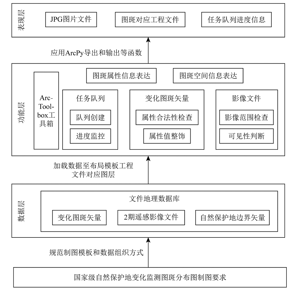
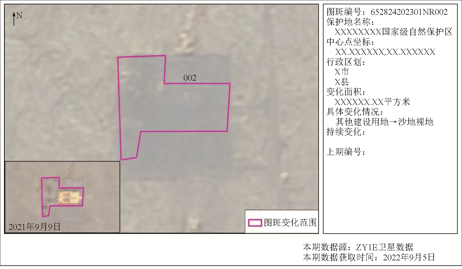
Remote sensing monitoring in national-level nature reserves covers a land area of approximately 1.7 million km2. This process involves the delineation of numerous features that indicate variations in the nature reserves, requiring specialized expertise. As a result, ensuring the accuracy and normalization of mapping is challenging even using substantial human and material resources. This affects the quality and effectiveness of monitoring result applications and relevant services. To address this issue, employing geometric techniques like the Sutherland-Hodgman clipping algorithm based on the ArcPy package, along with the customized ArcToolbox tools for encapsulating automated mapping scripts, this study automatically extracted the information and images of features from a geographic database. Subsequently, this study automatically generated the distribution maps of features that reflected variations in national-level nature reserves. Over 50000 maps were plotted using the proposed method, with an accuracy of 100%. Practical application demonstrates that the automatic mapping for a single map can be completed within 29.06 s on average, significantly less than manual mapping. The proposed method can meet practical production needs, with the automated mapping scripts proving stable, reliable, and widely applicable. The proposed method can significantly enhance the efficiency of the applications of the monitoring results reflecting variations in the national-level nature reserves, holding great practical significance.
王体鑫, 杨金中, 邢宇, 王开建. 基于ArcPy与图面优化的国家级自然保护地遥感监测成果自动制图方法[J]. 自然资源遥感, 2025, 37(1): 252-259.
WANG Tixin, YANG Jinzhong, XING Yu, WANG Kaijian. A method for automatic mapping of the remote sensing monitoring results of national nature reserves based on ArcPy and map optimization. Remote Sensing for Natural Resources, 2025, 37(1): 252-259.
Xinhua News Agency. The general office of the central committee of the CPC and the general office of the state council print and issue the guiding opinions on establishing a system of natural reserves with National Parks as the main body[J]. Gazette of the State Council of the People’s Republic of China, 2019(19):16-21.
Nature reserve research center of national forestry and grassland administration. The 1st China international forum on nature conservation was held[EB/OL].(2019-11-01) [2023-10-17].http://www.fnrrc.com/chinese/hydt/showcolumns.asp?ID=6109.
[3]
梅安新. 遥感导论[M]. 北京: 高等教育出版社,2001:5-6.
Mei A X. An introduction to remote sensing[M]. Beijing: Higher Education Press,2001:5-6.
Chen D, Yao W L. Automatic numbering and method improvement of mine patches based on ArcPy and custom ArcToolbox[J]. Remote Sensing for Land and Resources, 2021, 33(2):262-269.doi:10.6046/gtzyyg.2020181.
Wu B B, Xu Q, Li H X Y, et al. Analysis of the current situation of map symbol design in commonly used GIS cartographic software[J]. Geomatics & Spatial Information Technology, 2022, 45(12):106-109.
Xu J, Zhang Y, Zhou Q, et al. Refined design and implementation of the thematic map of earthquake emergency in Sichuan based on QGIS[J]. Earthquake Research in Sichuan, 2022(1):24-29.
Zhang W, Qiu C T, Xie M H, et al. Automatic drawing of geological interpretation map by Python[J]. Geophysical and Geochemical Exploration, 2021, 45(1):186-191.
Ma H L, Li H W, Wang Z L. Rapid mapping technology of district and county level emergency map in A Province[J]. Geomatics Technology and Equipment, 2021, 23(3):57-61.
Zhang Q L. Practice of graph-database integration data production based on 1∶10 000 DLG[J]. Geomatics & Spatial Information Technology, 2022, 45(8):259-261.
Wang X. Research on the method of quickly compiling atlas using ArcGIS data-driven pages[J]. Geomatics & Spatial Information Technology, 2023, 46(7):79-81.
Wang Y H, Yu Y J, Wen Z X, et al. Industrial mapping technology and application of oil & gas resources and basin evaluation based on ArcGIS software[J]. Journal of Earth Sciences and Environment, 2022, 44(4):675-684.
Diao M G, Xue T, Li J C, et al. Production data compilation system of mine remote sensing monitoring based on ArcGIS[J]. Remote Sensing for Land and Resources, 2016, 28(3):194-199.doi: 10.6046/gtzyyg.2016.03.30.
Diao M G, Liu F, Tan Z T, et al. Research and implement on automatic production method of mine remote sensing monitoring interpretation record table[J]. Remote Sensing for Land and Resources, 2018, 30(4):212-217.doi: 10.6046/gtzyyg.2018.04.32.
Che Z J, Li H B, Jia Q, et al. Design and implementation of soil survey results mapping software[J]. China Agricultural Informatics, 2022, 34(6):59-66.
[16]
ESRI. What is ArcPy?—ArcMap | Documentation[EB/OL] [2023-07-13].https://desktop.arcgis.com/en/arcmap/latest/analyze/arcpy/what-is-arcpy-.htm.
Li X, Liu Y, Yao W L, et al. Automatic plotting of illegal mines based on ArcPy[J]. Remote Sensing for Land and Resources, 2020, 32(3):247-251.doi: 10.6046/gtzyyg.2020.03.32.
Wu H Q, Xiong W K, Nie C H, et al. Application of ArcPy scripting tool in quality control of new fundamental surveying and mapping[J]. Bulletin of Surveying and Mapping, 2022(8):160-164.
Zhang T C, He H, Li D D, et al. Design and implementation of crop productivity thematic map system based on GIS[J]. Chinese Agricultural Science Bulletin, 2023, 39(7):153-157.
doi: 10.11924/j.issn.1000-6850.casb2022-0261
Ou D D, Zhang Q, Yin Q Q, et al. Optimization of automatic drawing method for sub-compartment design drawings of Changshun County national reserve forest implementation plan based on arcpy[J]. Central South Forest Inventory and Planning, 2023, 42(1):37-42.
Lin J B. ArcGIS data-driven mapping and batch mapping based on ArcPy:Taking the evaluation of cultivated land quality as an example[J]. Journal of Minxi Vocational and Technical College, 2021, 23(3):104-108.
Diao M G, Xue T, Li J C, et al. The multi-source spatial data management system based on geological information metadata standard[J]. Remote Sensing for Land and Resources, 2013, 25(1):165-170.doi:10.6046/gtzyyg.2013.01.29.
Diao M G, Zhao Y Y, Zhao D N, et al. Automatic generation method of production data report of mine remote sensing monitoring[J]. Science Technology and Engineering, 2020, 20(3):1107-1112.
[25]
Sutherland I E, Hodgman G W. Reentrant polygon clipping[J]. Communications of the ACM, 1974, 17(1):32-42.
[26]
Weiler K, Atherton P. Hidden surface removal using polygon area sorting[C]// Proceedings of the 4th annual conference on Computer graphics and interactive techniques.San Jose California. ACM,1977:214-222.
[27]
Vatti B R. A generic solution to polygon clipping[J]. Communications of the ACM, 1992, 35(7):56-63.
 2025, Vol. 37
  ), 杨金中1(