Please wait a minute...
 
自然资源遥感  2025, Vol. 37 Issue (3): 170-182    DOI: 10.6046/zrzyyg.2023403
  技术应用 本期目录 | 过刊浏览 | 高级检索 |
基于SRP的长江经济带江苏段生态脆弱性评价与分析
汪媛媛1(), 臧协超2(), 许伟伟1, 阳昌霞2, 金洋1, 任静华1, 贺新星1
1.江苏省地质调查研究院,自然资源部国土(耕地)生态监测与修复工程技术创新中心,南京 210018
2.成都理工大学地球科学学院,成都 610059
SRP model-based assessment and analysis of ecological vulnerability in the Yangtze River economic belt within Jiangsu Province
WANG Yuanyuan1(), ZANG Xiechao2(), XU Weiwei1, YANG Changxia2, JIN Yang1, REN Jinghua1, HE Xinxing1
1. Geological Survey of Jiangsu Province, Research Institute Engineering Technology Innovation Center for Land(Cropland) Ecological Monitoring and Rehabilitation, Ministry of Natural Resources, Nanjing 210018, China
2. College of Earth Science, Chengdu University of Technology, Chengdu 610059, China
全文: PDF(9333 KB)   HTML  
输出: BibTeX | EndNote (RIS)      
摘要 

随着社会经济发展和城镇化率不断提高,人类赖以生存的生态环境受到影响,尤其是长江经济带江苏段受城市化和土地开发等影响,生态质量面临严峻挑战,生态脆弱性评价已成为研究热点之一。该文以长江经济带江苏段2005—2020年4个时期生态脆弱性为研究对象,采用灵敏度弹性压力(sensitivity resilience pressure,SRP)模型,选取生态恢复力、生态压力度和生态敏感性3类16项指标,基于结合层次分析法与空间主成分分析法(analytic hierarchy process-spatial principal component analysis,AHP-SPCA)权重计算方法和地理探测器,研究生态脆弱性特征和影响因素。研究发现: ①研究区生态脆弱性呈现出从南京向南通逐渐增加趋势; ②生态脆弱性等级之间转变主要发生在相邻等级之间,中度和重度脆弱性减小,轻度、微度和潜在脆弱性增加; ③耕地占比、人口密度和生物丰度是主要驱动因素,植被覆盖与耕地占比的交互作用具有最大解释力。研究结果对江苏省长江沿岸生态环境保护和可持续发展提供了重要参考。

服务
把本文推荐给朋友
加入引用管理器
E-mail Alert
RSS
作者相关文章
汪媛媛
臧协超
许伟伟
阳昌霞
金洋
任静华
贺新星
关键词 长江经济带生态敏感性-生态恢复力-生态压力度模型地理探测器生态脆弱性驱动力    
Abstract

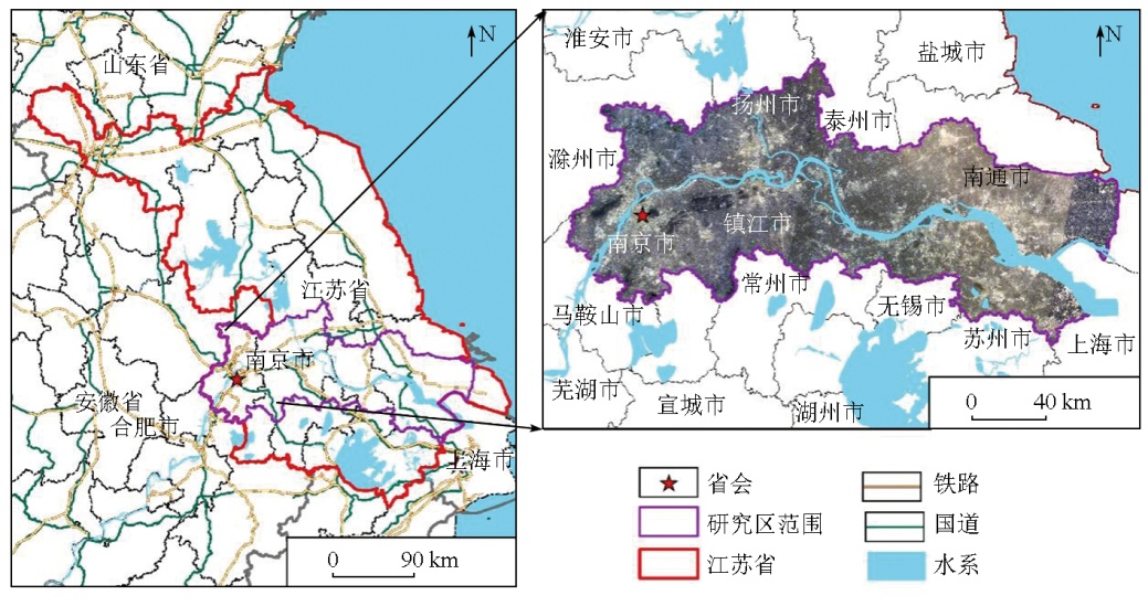
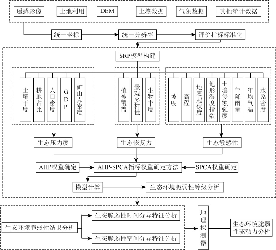
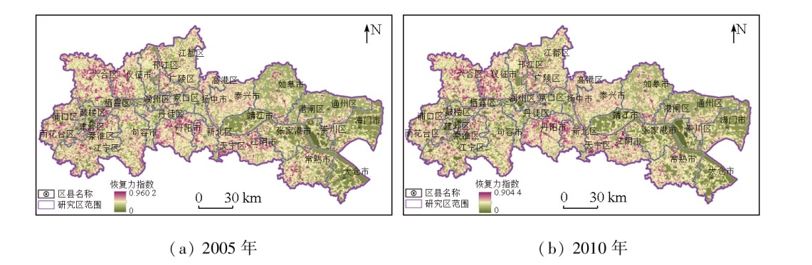
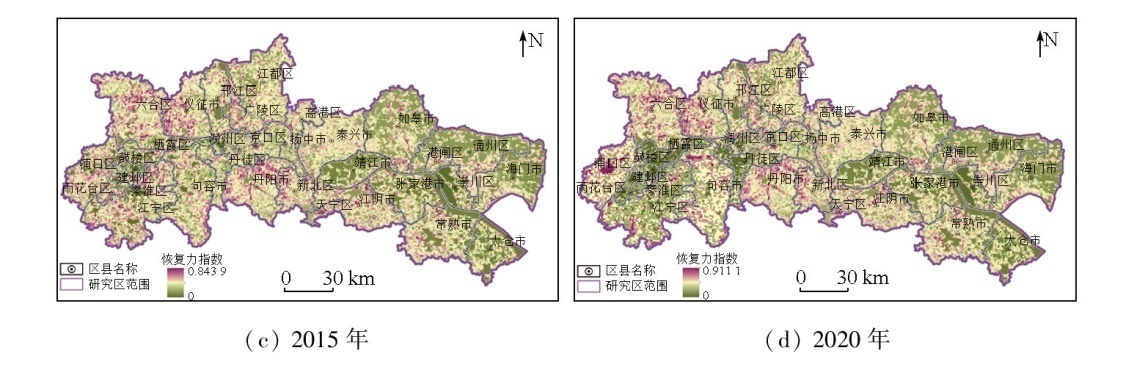
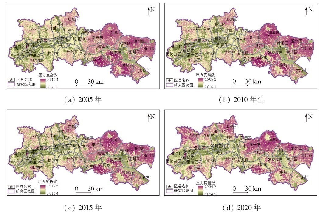
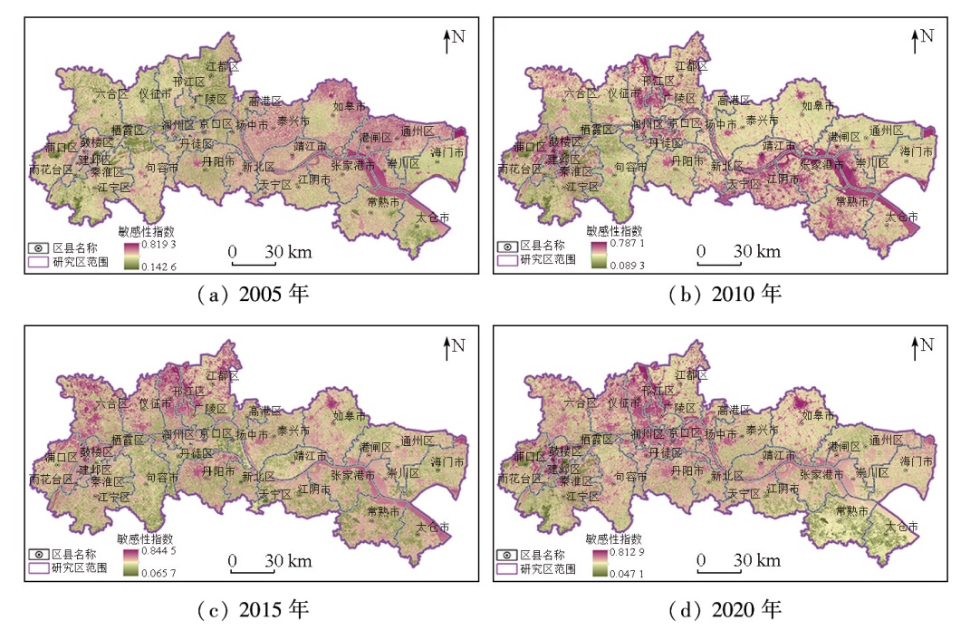
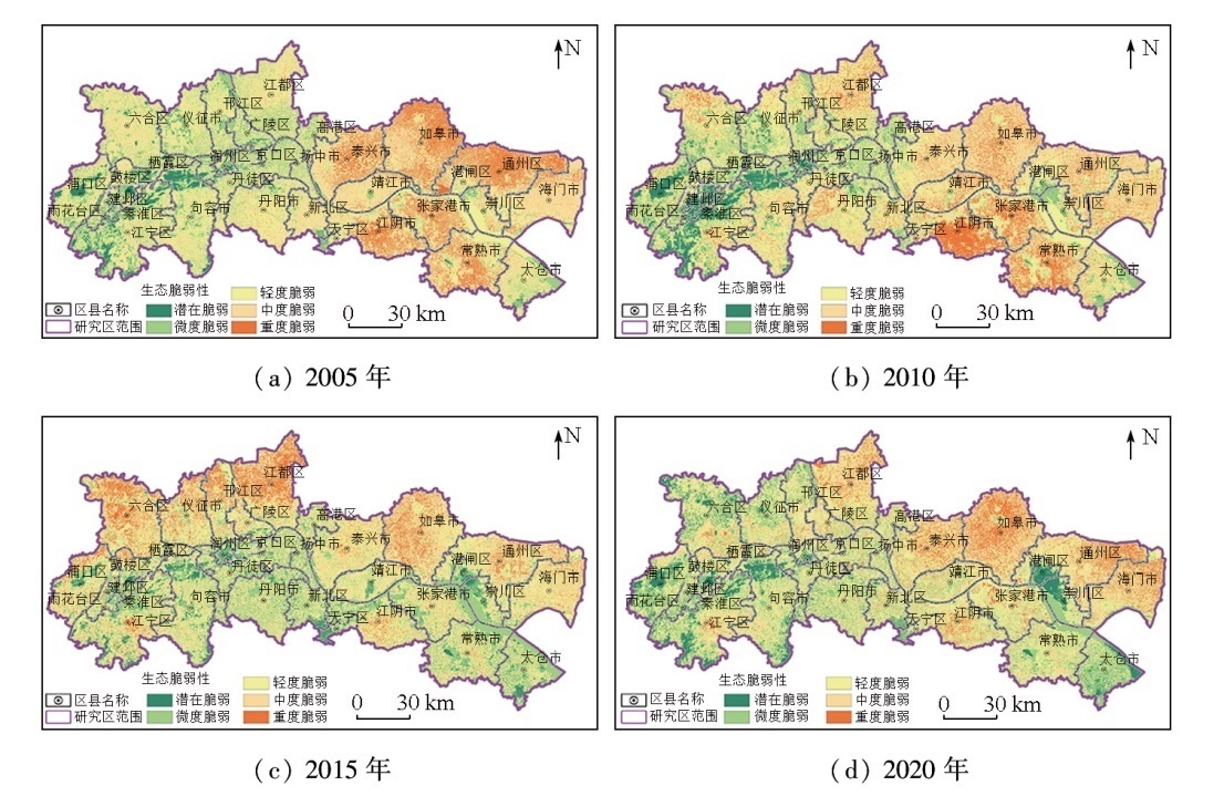
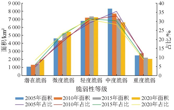
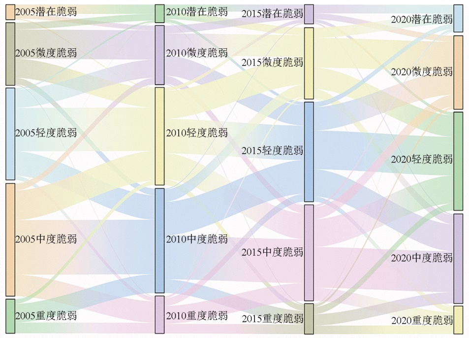
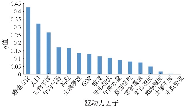
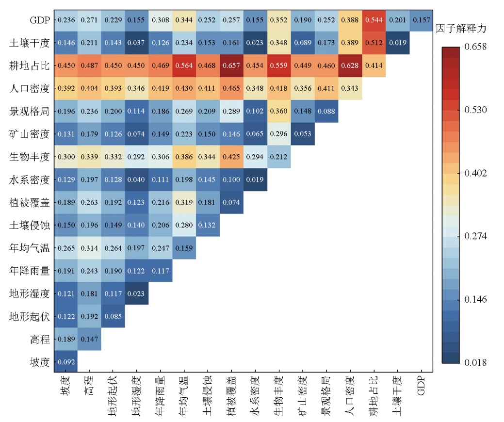
Socioeconomic development and intensified urbanization have influenced ecosystems essential for human survival. In particular, the ecological quality of the Yangtze River economic belt (YREB) within Jiangsu Province has been significantly challenged due to urbanization and land development, establishing ecological vulnerability assessment as a prominent focus. This study investigated the ecological vulnerability in the YREB within Jiangsu Province across four periods from 2005 to 2020, based on the sensitivity-resilience-pressure (SRP) model that involves 16 indicators in three categories: ecological resilience, pressure, and sensitivity. Using the analytic hierarchy process-selective principal component analysis (AHP-SPCA) weighting method and geodetector, this study delved into the characteristics and drivers of ecological vulnerability. The results indicate that the ecological vulnerability in the study area increased gradually from Nanjing to Nantong cities. Ecological vulnerability levels shift primarily between adjacent levels, characterized by decreased moderate/severe vulnerability and increased mild/slight/potential vulnerability. Primary drivers of ecological vulnerability include the proportion of arable land, population density, and biodiversity, with the interaction between vegetation cover and the proportion of arable land showing the highest explanatory power. Overall, the results of this study provide a significant reference for ecosystem conservation and sustainable development along the Yangtze River within Jiangsu Province.

Key wordsYangtze River economic belt (YREB)    sensitivity-resilience-pressure (SRP) model    geodetector    ecological vulnerability    driver
收稿日期: 2023-12-27      出版日期: 2025-07-01
ZTFLH:  TP79  
  X826  
基金资助:2020年江苏省自然资源发展专项资金项目“江苏省国土空间生态监测”(苏财资环[2020]20号);2022年江苏省地质勘查资金项目“江苏省国土空间生态监测(2022-2025年)”(苏财资环[2022]27号);自然资源部国土(耕地)生态监测与修复工程技术创新中心开放课题基金项目“基于多要素动态监测的农田生态系统演变模拟预测与评价”(GTST2021-002)
通讯作者: 臧协超(1998-),男,硕士研究生,研究方向为遥感在生态环境方面的应用。Email: zangxiechao@163.com
作者简介: 汪媛媛(1984-),女,高级工程师,研究方向为地球化学调查和监测工作。Email: hengrucc@126.com
引用本文:   
汪媛媛, 臧协超, 许伟伟, 阳昌霞, 金洋, 任静华, 贺新星. 基于SRP的长江经济带江苏段生态脆弱性评价与分析[J]. 自然资源遥感, 2025, 37(3): 170-182.
WANG Yuanyuan, ZANG Xiechao, XU Weiwei, YANG Changxia, JIN Yang, REN Jinghua, HE Xinxing. SRP model-based assessment and analysis of ecological vulnerability in the Yangtze River economic belt within Jiangsu Province. Remote Sensing for Natural Resources, 2025, 37(3): 170-182.
链接本文:  
https://www.gtzyyg.com/CN/10.6046/zrzyyg.2023403      或      https://www.gtzyyg.com/CN/Y2025/V37/I3/170
Fig.1  研究区概况图
数据类型 数据内容 数据来源 用途
遥感影像数据 主要是Landsat系列卫星数据 https://earthexplorer.usgs.gov/ 计算植被覆盖、土壤干度
DEM数据 2010 年分辨率 30 m 的 ASTER GDEM 数据 地理空间数据云(http: //www.gscloud.cn/) 计算坡度、高程、地表起伏度、坡长因子、地形湿度指数[20]
土壤数据 全国1∶100万土壤类型数据 中国科学院资源环境科学数据中心(http: //www.resdc.cn/) 计算土壤可侵蚀性
气象数据 江苏省长江沿岸周边站点年降雨量数据和年均气温数据 中国气象数据共享服务网
(cdc.nimc.cn/home.do)
计算年降雨量、年均气温
土地利用数据 江苏省2005—2020年30 m分辨率土地利用数据 中国地质调查局地质云 2.0
(https://geocloud.cgs.gov.cn/)
计算景观多样性、生物丰度、耕地占比
社会经济类数据 2005—2020年各时段相关经济指标数据、人口数据等 《江苏省统计年鉴》 计算人口密度、国内生产总值(gross domestic product,GDP)
河网矢量数据 江苏省水系数据 中国地质调查局地质云 2.0
(https://geocloud.cgs.gov.cn/)
计算水系密度
矿区点数据 研究内矿区点数据以及长江沿岸范围内露天矿山修复区数据 江苏省长江沿岸国土空间遥感监测
项目
计算矿区点干扰密度
Tab.1  不同数据类型及数据来源
Fig.2  研究技术路线图
指标因子 W 1 i 2005年 2010年 2015年 2020年
W2i Wi W2i Wi W2i Wi W2i Wi
坡度 0.063 3 0.000 7 0.008 9 0.001 2 0.011 8 0.002 5 0.016 7 0.003 8 0.020 3
高程 0.027 3 0.000 8 0.006 4 0.001 3 0.008 0 0.002 0 0.009 8 0.003 5 0.012 8
地形起伏 0.010 5 0.000 2 0.002 1 0.000 4 0.002 8 0.000 9 0.004 0 0.001 3 0.004 7
地形湿度 0.029 9 0.007 9 0.020 6 0.008 3 0.021 0 0.053 4 0.052 9 0.059 7 0.055 0
年均降雨 0.099 6 0.147 1 0.161 6 0.129 0 0.151 3 0.123 4 0.146 7 0.116 8 0.140 5
年均气温 0.033 2 0.114 8 0.082 4 0.126 1 0.086 4 0.111 2 0.080 3 0.075 6 0.065 2
土壤侵蚀 0.196 2 0.000 2 0.008 4 0.000 4 0.011 2 0.000 1 0.006 6 0.000 2 0.007 9
植被覆盖 0.098 1 0.164 9 0.169 8 0.159 5 0.167 0 0.164 9 0.168 2 0.162 0 0.164 1
水系密度 0.041 9 0.005 3 0.019 9 0.004 4 0.018 1 0.020 7 0.038 9 0.018 8 0.036 5
生物丰度 0.029 7 0.029 9 0.039 8 0.044 4 0.048 5 0.023 4 0.034 9 0.093 1 0.068 5
矿点密度 0.053 9 0.000 1 0.003 1 0.000 2 0.004 0 0.000 1 0.003 5 0.000 3 0.004 9
景观多样 0.016 4 0.161 2 0.068 6 0.164 0 0.069 2 0.165 6 0.068 9 0.162 8 0.067 3
人口密度 0.058 8 0.101 4 0.103 1 0.122 0 0.113 1 0.114 9 0.108 7 0.104 9 0.102 3
耕地占比 0.092 5 0.164 9 0.164 9 0.165 2 0.165 1 0.165 0 0.163 4 0.162 0 0.159 4
土壤干度 0.073 7 0.006 0 0.027 9 0.005 6 0.027 1 0.001 8 0.015 5 0.008 2 0.032 0
GDP 0.075 0 0.094 6 0.112 5 0.068 0 0.095 4 0.050 1 0.081 0 0.027 0 0.058 6
总计 1.000 0 1.000 0 1.000 0 1.000 0 1.000 0 1.000 0 1.000 0 1.000 0 1.000 0
Tab.2  2005年、2010年、2015年和2020年各评价指标权重
脆弱性类型 EVI 生态环境特征
潜在脆弱 [0,0.2] 区域内生态环境质量良好,能快速应对外界环境变化,生态环境自我恢复能力强,应对生态环境变化承压能力强,无异常生态环境问题出现
微度脆弱 (0.2,0.4] 区域内生态环境质量较好,生态环境自我恢复能力较强,应对外界环境变化能力较强,可以有效抵抗外界压力,存在使生态环境变差的潜在威胁因子
轻度脆弱 (0.4,0.6] 区域内生态环境质量一般,生态环境自我恢复能力处于中等水平,自身生态环境敏感性较高,生态环境适应能力中等,易产生一定的生态环境问题
中度脆弱 (0.6,0.8] 区域内生态环境质量差,生态环境表现出较高的敏感度和产生较大的压力,与此同时生态的可恢复性变得很差,生态恢复存在较大的阻力,恢复能力弱,生态问题较多
极度脆弱 (0.8,1.0] 区域内生态环境质量极差,生态环境敏感性高,自我恢复能力弱,生态环境问题严重,生态环境自我恢复难度极大,生态问题突出
Tab.3  生态环境脆弱性类型分级取值表
判断依据 交互作用类型
q(X1X2)<min[q(X1),q(X2)] 非线性减弱
min[q(X1),q(X2)]<q(X1X2)<
max[q(X1),q(X2)]
单因子非线性减弱
(X1X2)>max[q(X1),q(X2)] 双因子增强
q(X1X2)=q(X1)+q(X2) 独立
q(X1X2)>q(X1)+q(X2) 非线性增强
Tab.4  交互作用探测器交互作用类型分类
Fig.3-1  研究区内生态恢复力分布
Fig.3-2  研究区内生态恢复力分布
Fig.4  研究区内生态压力度分布
Fig.5  研究区内生态敏感性分布
Fig.6  研究区内生态脆弱性分布
Fig.7  不同脆弱性面积及占比统计
Fig.8  2005—2010年江苏省长江沿岸生态环境脆弱性等级转移图
Fig.9  驱动力因子对生态环境脆弱性q
Fig.10  生态脆弱性驱动力因子交互作用图
Fig.11  某采石宕口生态修复前(左)后(右)脆弱性对比
[1] 韩博, 金晓斌, 项晓敏, 等. 基于“要素—景观—系统”框架的江苏省长江沿线生态修复格局分析与对策[J]. 自然资源学报, 2020, 35(1):141-161.
doi: 10.31497/zrzyxb.20200113
Han B, Jin X B, Xiang X M, et al. Exploration of ecological restoration pattern and countermeasure along the Yangtze River in Jiangsu Province based on the “element-landscape-system” framework[J]. Journal of Natural Resources, 2020, 35(1):141-161.
[2] Nasir M A, Canh N P, Le T N L. Environmental degradation and role of financialisation,economic development,industrialisation and trade liberalisation[J]. Journal of Environmental Management, 2021,277:111471.
[3] Ozcan B, Tzeremes P G, Tzeremes N G. Energy consumption,economic growth and environmental degradation in OECD countries[J]. Economic Modelling, 2020,84:203-213.
[4] Jagtap T G, Komarpant D S, Rodrigues R S. Status of a seagrass ecosystem:An ecologically sensitive wetland habitat from India[J]. Wetlands, 2003, 23(1):161-170.
[5] Eggermont H, Verschuren D, Audenaert L, et al. Limnological and ecological sensitivity of Rwenzori Mountain lakes to climate warming[J]. Hydrobiologia, 2010, 648(1):123-142.
[6] 徐广才, 康慕谊, 贺丽娜, 等. 生态脆弱性及其研究进展[J]. 生态学报, 2009, 29(5):2578-2588.
Xu G C, Kang M Y, He L N, et al. Advances in research on ecological vulnerability[J]. Acta Ecologica Sinica, 2009, 29(5):2578-2588.
[7] 袁晓蕾, 王超, 李柏延, 等. 长江流域土地利用/覆盖变化驱动力及影响综述[J]. 武汉大学学报(信息科学版), 2023, 48(8):1241-1255.
Yuan X L, Wang C, Li B Y, et al. Review of the driving forces and impacts of land use/cover change in the Yangtze River Basin[J]. Geomatics and Information Science of Wuhan University, 2023, 48(8):1241-1255.
[8] 王柯, 张建军, 邢哲, 等. 我国生态问题鉴定与国土空间生态保护修复方向[J]. 生态学报, 2022, 42(18):7685-7696.
Wang K, Zhang J J, Xing Z, et al. Identification of ecological problems in China and the direction of ecological protection and restoration of national space[J]. Acta Ecologica Sinica, 2022, 42(18):7685-7696.
[9] 李旭亮, 杨礼箫, 田伟, 等. 中国北方农牧交错带土地利用/覆盖变化研究综述[J]. 应用生态学报, 2018, 29(10):3487-3495.
doi: 10.13287/j.1001-9332.201810.020
Li X L, Yang L X, Tian W, et al. Land use and land cover change in agro-pastoral ecotone in Northern China:A review[J]. Chinese Journal of Applied Ecology, 2018, 29(10):3487-3495.
[10] 李念春, 袁辉. 黄河三角洲高效生态经济区生态环境脆弱性评价研究[J]. 山东国土资源, 2015, 31(10):57-61.
Li N C, Yuan H. Evaluation and study on ecological vulnerability of efficient ecological economic zone in the Yellow River Delta area[J]. Shandong Land and Resources, 2015, 31(10):57-61.
[11] 陆海燕, 孙桂丽, 李路, 等. 基于VSD模型的新疆生态脆弱性评价[J]. 新疆农业科学, 2020, 57(2):292-302.
doi: 10.6048/j.issn.1001-4330.2020.02.010
Lu H Y, Sun G L, Li L, et al. Ecological vulnerability assessment in Xinjiang based on VSD model[J]. Xinjiang Agricultural Sciences, 2020, 57(2):292-302.
doi: 10.6048/j.issn.1001-4330.2020.02.010
[12] 邵怀勇. 攀西矿业开发集中区生态环境遥感信息提取及生态安全评价研究[D]. 成都: 成都理工大学, 2009.
Shao H Y. Remote sensing information extraction of ecological environment and eco-security evaluation in panxi mining concentrated area[D]. Chengdu: Chengdu University of Technology, 2009.
[13] 薛联青, 王晶, 魏光辉. 基于PSR模型的塔里木河流域生态脆弱性评价[J]. 河海大学学报(自然科学版), 2019, 47(1):13-19.
Xue L Q, Wang J, Wei G H. Dynamic evaluation of the ecological vulnerability based on PSR modeling for the Tarim River Basin in Xinjiang[J]. Journal of Hohai University (Natural Sciences), 2019, 47(1):13-19.
[14] 吴春生, 黄翀, 刘高焕, 等. 基于模糊层次分析法的黄河三角洲生态脆弱性评价[J]. 生态学报, 2018, 38(13):4584-4595.
Wu C S, Huang C, Liu G H, et al. Assessment of ecological vulnerability in the Yellow River Delta using the fuzzy analytic hierarchy process[J]. Acta Ecologica Sinica, 2018, 38(13):4584-4595.
[15] 李霞, 朱万泽, 舒树淼, 等. 基于主成分分析的大渡河中游干暖河谷草地土壤质量评价[J]. 生态学报, 2021, 41(10):3891-3900.
Li X, Zhu W Z, Shu S M, et al. Soil quality assessment of grassland in dry and warm valley of Dadu River based on principal component analysis[J]. Acta Ecologica Sinica, 2021, 41(10):3891-3900.
[16] 宁雅楠, 李贝, 杨伟州, 等. 基于主成分分析法的土地利用景观分区研究——以青龙满族自治县为例[J]. 中国农业资源与区划, 2016, 37(2):22-28.
Ning Y N, Li B, Yang W Z, et al. Landscape zoning of land use based on principal component analysis:A case study of Qinglong Manchu Autonomous County[J]. Chinese Journal of Agricultural Resources and Regional Planning, 2016, 37(2):22-28.
[17] 许章华, 陈文慧, 石文春, 等. 福州新区建设背景下生态脆弱性的演变研究[J]. 遥感信息, 2021, 36(6):34-43.
Xu Z H, Chen W H, Shi W C, et al. Evolution of ecological vulnerability in Fuzhou new district under construction[J]. Remote Sen-sing Information, 2021, 36(6):34-43.
[18] 刘琳, 吴云飞. 基于AHP-模糊综合评价法的东北地区林业生态建设研究[J]. 森林工程, 2023, 39(3):82-90.
Liu L, Wu Y F. Research on the ecological construction of forestry in Northeast China based on AHP-fuzzy comprehensive evaluation method[J]. Forest Engineering, 2023, 39(3):82-90.
[19] 陆志翔, 肖洪浪, Wei Yongping, 等. 黑河流域近两千年人—水—生态演变研究进展[J]. 地球科学进展, 2015, 30(3):396-406.
doi: 10.11867/j.issn.1001-8166.2015.03.0396
Lu Z X, Xiao H L, Wei Y P, et al. Advances in the study on the human- water- ecology evolution in the past two thousand years in Heihe River Basin[J]. Advances in Earth Science, 2015, 30(3):396-406.
[20] 秦承志, 杨琳, 朱阿兴, 等. 平缓地区地形湿度指数的计算方法[J]. 地理科学进展, 2006, 25(6):87-93,157.
Qin C Z, Yang L, Zhu A X, et al. Computation method of topographic wetness index in low relief area[J]. Progress in Geography, 2006, 25(6):87-93,157.
[21] 田丰收, 刘新平, 原伟鹏. 新疆和田地区耕地面源污染生态风险评价[J]. 干旱区地理, 2019, 42(2):295-304.
Tian F S, Liu X P, Yuan W P. Ecological risk assessment of farmland non-point source pollution in Hotan Prefecture,Xinjiang[J]. Arid Land Geography, 2019, 42(2):295-304.
[22] 齐姗姗. 流域生态脆弱性与生态系统服务相关关系研究——以甘肃白龙江流域为例[D]. 兰州: 兰州大学, 2017.
Qi S S. Correlation between watershed ecological vulnerability and ecosystem services:A case study of Bailongjiang watershed in southern Gansu[D]. Lanzhou: Lanzhou University, 2017.
[23] 张良侠, 樊江文, 张海燕, 等. 黄土高原地区生态脆弱性时空变化及其驱动因子分析[J]. 环境科学, 2022, 43(9):4902-4910.
Zhang L X, Fan J W, Zhang H Y, et al. Spatial-temporal variations and their driving forces of the ecological vulnerability in the Loess Plateau[J]. Environmental Science, 2022, 43(9):4902-4910.
[24] 张雪茂, 董廷旭, 杜华明, 等. 基于景观生态风险评价的涪江流域景观格局优化[J]. 生态学报, 2021, 41(10):3940-3951.
Zhang X M, Dong T X, Du H M, et al. Optimization of landscape pattern in Fujiang River Basin based on landscape ecological risk assessment[J]. Acta Ecologica Sinica, 2021, 41(10):3940-3951.
[25] 王跃, 刘家福, 周林鹏, 等. 基于AHP-SPCA熵权模型的松花江流域生态脆弱性时空演变及预测[J]. 水土保持通报, 2023, 43(2):212-219,360.
Wang Y, Liu J F, Zhou L P, et al. Temporal and spatial evolution and prediction of ecological vulnerability in Songhua River Basin based on AHP-SPCA entropy weight model[J]. Bulletin of Soil and Water Conservation, 2023, 43(2):212-219,360.
[26] 高化雨, 韩会玲, 张晶, 等. 基于生态脆弱性评价的松花湖湖滨带功能区划研究[J]. 水生态学杂志, 2019, 40(6):1-7.
Gao H Y, Han H L, Zhang J, et al. Lakeside function division of Songhua Lake based on ecological vulnerability evaluation[J]. Journal of Hydroecology, 2019, 40(6):1-7.
[27] 田超, 杨夏捷, 鞠园华, 等. 吉林省西部地区生态脆弱性的动态评价[J]. 水土保持研究, 2018, 25(4):298-303.
Tian C, Yang X J, Ju Y H, et al. Dynamic evaluation of ecological vulnerability in western Jilin Province[J]. Research of Soil and Water Conservation, 2018, 25(4):298-303.
[28] 范强. 基于SRP模型资源枯竭型城市生态脆弱性时空分异研究——以阜新市为例[D]. 大连: 辽宁师范大学, 2017.
Fan Q. SRP model based spatial-temporal differentiation analysis of ecological vulnerability for resources-exhausted region:A case study for Fuxin[D]. Dalian: Liaoning Normal University, 2017.
[29] 何盈利, 尤南山, 崔耀平, 等. 2000年来中国生态状况时空变化格局[J]. 自然资源学报, 2021, 36(5):1176-1185.
doi: 10.31497/zrzyxb.20210507
He Y L, You N S, Cui Y P, et al. Spatio-temporal changes in remote sensing-based ecological index in China since 2000[J]. Journal of Natural Resources, 2021, 36(5):1176-1185.
[30] 王劲峰, 徐成东. 地理探测器:原理与展望[J]. 地理学报, 2017, 72(1):116-134.
doi: 10.11821/dlxb201701010
Wang J F, Xu C D. Geodetector:Principle and prospective[J]. Acta Geographica Sinica, 2017, 72(1):116-134.
[31] 徐超璇, 鲁春霞, 黄绍琳. 张家口地区生态脆弱性及其影响因素[J]. 自然资源学报, 2020, 35(6):1288-1300.
doi: 10.31497/zrzyxb.20200603
Xu C X, Lu C X, Huang S L. Study on ecological vulnerability and its influencing factors in Zhangjiakou area[J]. Journal of Natural Resources, 2020, 35(6):1288-1300.
[32] 叶妍君, 齐清文, 姜莉莉, 等. 基于地理探测器的黑龙江垦区农场粮食产量影响因素分析[J]. 地理研究, 2018, 37(1):171-182.
doi: 10.11821/dlyj201801013
Ye Y J, Qi Q W, Jiang L L, et al. Impact factors of grain output from farms in Heilongjiang reclamation area based on geographical detector[J]. Geographical Research, 2018, 37(1):171-182.
[1] 陆建涛, 郑江华, 彭建, 肖向华, 李刚勇, 刘亮, 王仁军, 张建立. 新疆生态脆弱性时空演变特征及其对干旱的响应[J]. 自然资源遥感, 2025, 37(3): 253-264.
[2] 孙娅琴, 邸宝刚, 邢宇, 安娜, 张仙. 长江经济带湖北段废弃露天矿山生态修复遥感动态监测和生态修复效果评价[J]. 自然资源遥感, 2025, 37(3): 32-44.
[3] 奥勇, 汪雅, 王晓峰, 吴京盛, 张亦恒, 李雪娇. 2001—2020年间河南省郑州市生态环境质量时空变化及驱动因素分析[J]. 自然资源遥感, 2025, 37(1): 102-112.
[4] 鲁军景, 孙雷刚, 左璐, 刘剑锋, 马晓倩, 郝庆涛. 基于京津冀功能分区的植被覆盖度时空演变特征及其影响因子[J]. 自然资源遥感, 2024, 36(4): 242-253.
[5] 苏悦, 刘洪, 杨武年, 欧阳渊, 张景华, 张腾蛟, 黄勇. 高原山地区域生态脆弱性研究——以四川省康定市为例[J]. 自然资源遥感, 2024, 36(3): 206-215.
[6] 胡苗苗, 闫庆武, 李建辉. 基于DMSP/OLS和NPP/VIIRS夜光影像的中原城市群城市扩张的时空演变及驱动力分析[J]. 自然资源遥感, 2024, 36(1): 189-199.
[7] 吴冰洁, 文广超, 赵梅娟, 谢洪波, 冯雅杰, 贾琳. 基于Landsat的巴音河流域生态环境综合演化分析[J]. 自然资源遥感, 2024, 36(1): 227-234.
[8] 崔囤月, 王世东, 张学军. 1991—2021年雄安新区土地利用与植被覆盖变化遥感研究[J]. 自然资源遥感, 2023, 35(4): 214-225.
[9] 李光哲, 王浩, 曹银璇, 张晓宇, 宁晓刚. 长株潭城市群生态环境质量时空演变及影响因素分析[J]. 自然资源遥感, 2023, 35(4): 244-254.
[10] 田柳兰, 吕思雨, 毋兆鹏, 王娟娟, 史欣鹏. 乌鲁木齐市土地利用变化及其空间冲突测度[J]. 自然资源遥感, 2023, 35(4): 282-291.
[11] 王叶兰, 杨鑫, 郝利娜. 2001—2021年川西高原植被NDVI时空变化及影响因素分析[J]. 自然资源遥感, 2023, 35(3): 212-220.
[12] 李益敏, 杨舒婷, 吴博闻, 梁雨西, 孟月玥. 昆明市呈贡区不透水面时空变化及驱动力分析[J]. 自然资源遥感, 2022, 34(2): 136-143.
[13] 杨雯娜, 周亮, 孙东琪. 基于分区-集成的黄河流域生态脆弱性评价[J]. 自然资源遥感, 2021, 33(3): 211-218.
[14] 郝固状, 甘甫平, 闫柏琨, 李贤庆, 胡辉东. 红崖山水库近20年面积变化遥感调查及驱动力分析[J]. 国土资源遥感, 2021, 33(2): 192-201.
[15] 胡苏李扬, 李辉, 顾延生, 黄咸雨, 张志麒, 汪迎春. 基于高分辨率遥感影像的神农架大九湖湿地土地利用类型变化及其驱动力分析——来自长时间尺度多源遥感信息的约束[J]. 国土资源遥感, 2021, 33(1): 221-230.
Viewed
Full text


Abstract

Cited

  Shared   
  Discussed   
京ICP备05055290号-2
版权所有 © 2015 《自然资源遥感》编辑部
地址:北京学院路31号中国国土资源航空物探遥感中心 邮编:100083
电话:010-62060291/62060292 E-mail:zrzyyg@163.com
本系统由北京玛格泰克科技发展有限公司设计开发