Spatiotemporal evolution of impervious surface and the driving factors in Chenggong District,Kunming City
LI Yimin1,2(), YANG Shuting1, WU Bowen1, LIANG Yuxi1, MENG Yueyue3
1. School of Earth Sciences, Yunnan University, Kunming 650500, China 2. Research Center of Domestic High-Resolute Satellite Remote Sensing Geological Engineering, Kunming 650500, China 3. China Aero Geophysical Survey and Remote Sensing Center for Natural Resouces, Beijing 100083, China
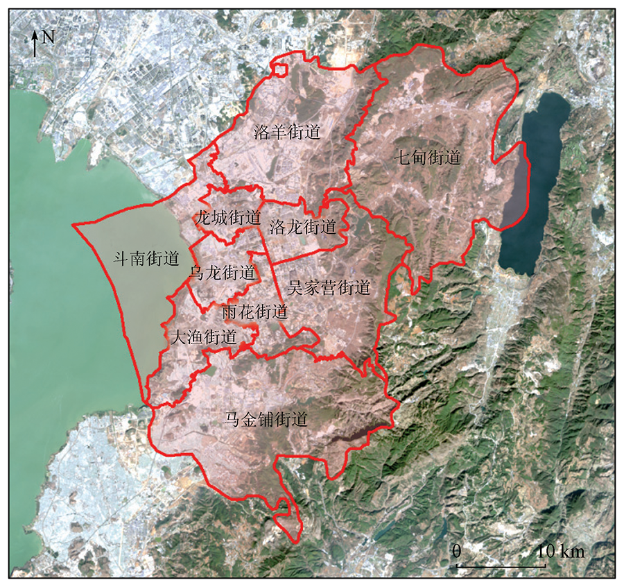
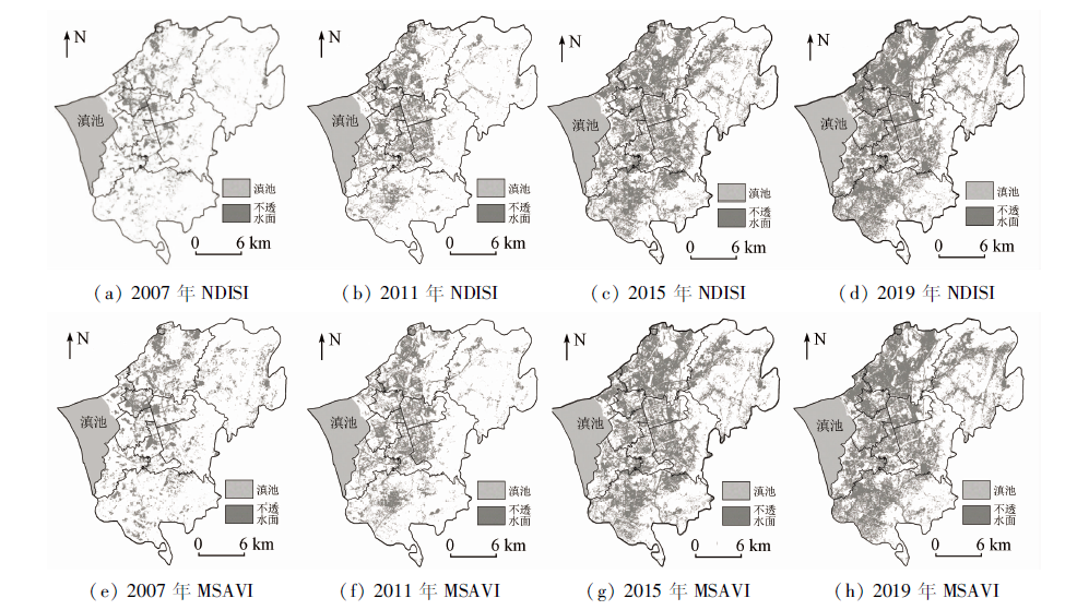
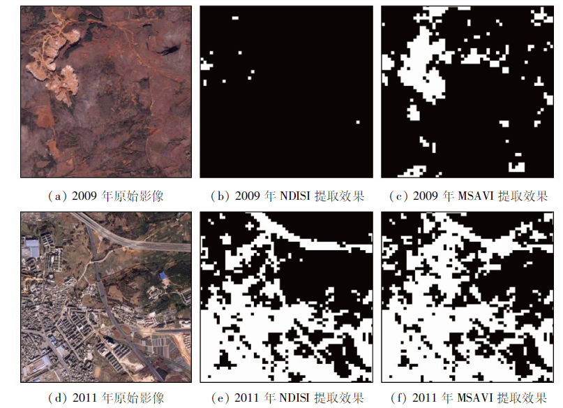
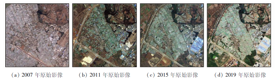
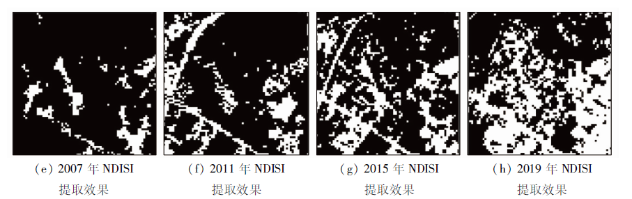
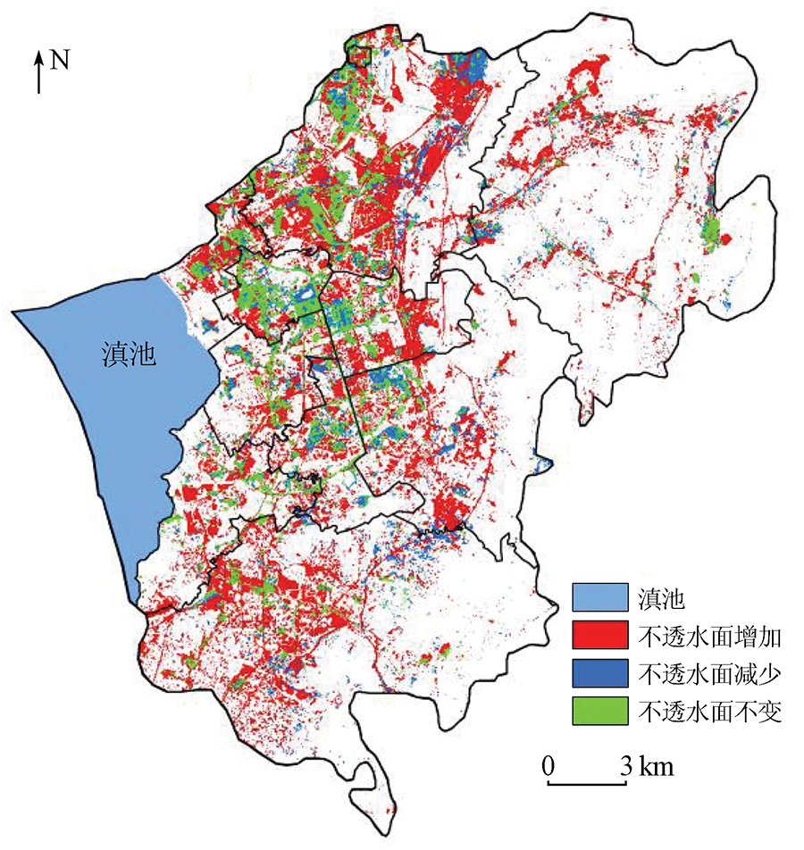
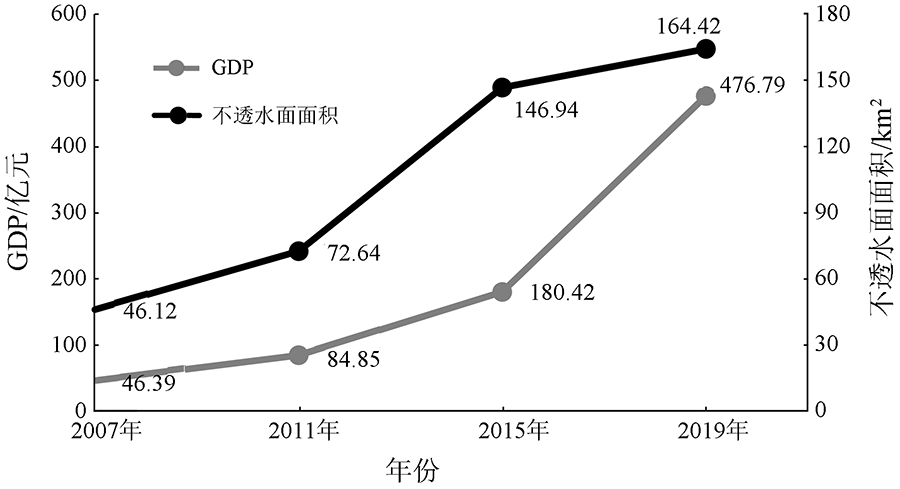
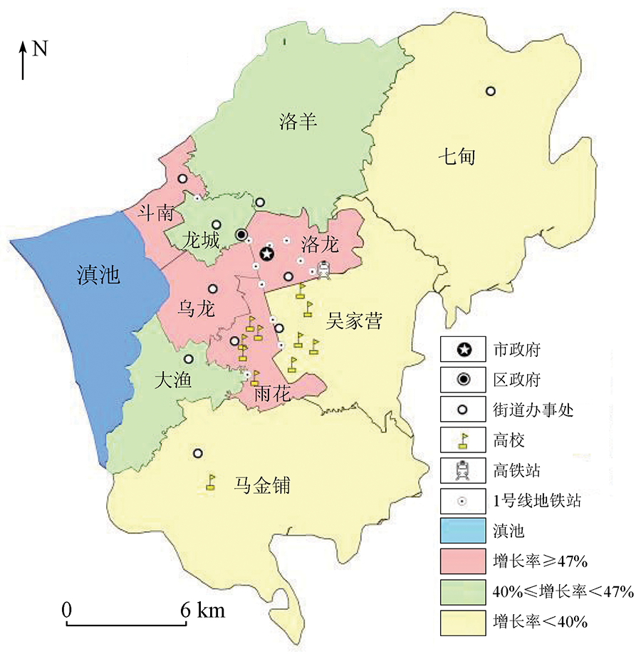
Impervious surface is a key factor to measure the urban ecological environment. It is of great significance for urban development planning to grasp the dynamic changes of impervious surfaces timely and accurately. Taking the Chenggong District of Kunming City as an example, based on the Landsat images in 2007, 2011, 2015, and 2019, the comparative study of normalized difference impervious surface index (NDISI) and modified soil adjusted vegetation index(MSAVI) was carried out to analyze the spatial and temporal evolution characteristics of impervious surface. The results showed that: ①As the extraction accuracy and Kappa coefficient of NDISI were 87.01% and 0.81, respectively, which were better than MSAVI’s 81.78% and 0.75, this paper selected the NDISI method to extract impervious surfaces in the Chenggong District;② the impervious surface area extracted in this paper increased from 46.12 km2 in 2007 to 72.64 km2 in 2011, 146.94 km2 in 2015 and 164.42 km2 in 2019, especially from 2011 to 2015, the impervious surface area had the fastest growth rate and nearly doubled. The changes to the impervious surface in Chenggong District are mainly influenced by such factors as national policies, urban planning, topographic factors, and traffic development. The impervious surface area along the Dianchi Lake in the west of Chenggong District and several administrative regions in the middle of Chenggong District developed rapidly, which brings certain pressure on the prevention and control of waterlogging in urban areas and the Dianchi Lake area. In the process of future urban planning, the expansion scope and speed of impervious surfaces should be well controlled to avoid ecological and environmental problems caused by the unreasonable spatial patterns of impervious surfaces.
Cai B W, Wang S G, Wang L, et al. Extraction of urban impervious surface from high-resolution remote sensing imagery based on deep learning[J]. Journal of Geo-Information Science, 2019, 21(9):1420-1429.
Zhou Z L, Sha J M, Fan Y X, et al. Temporal and spatial variations of impervious surface landscape pattern and the driving factors in Xiamen City,China[J]. Chinese Journal of Applied Ecology, 2020, 31(1):230-238.
[4]
Omurakunova G, Bao A M, Xu W Q, et al. Expansion of impervious surfaces and their driving forces in highly urbanized cities in Kyrgyzstan[J]. International Journal of Environmental Research and Public Health, 2020, 17(1):362.
doi: 10.3390/ijerph17010362
Li H, Li L, Zhang T, et al. Mapping and characterizing the spatio-temporal heterogeneity of impervious surface in Xuzhou urban area[J]. Resources and Environment in the Yangtze Basin, 2019, 28(3):668-680.
Liu C, Yang K, Cheng L, et al. Comparison of Landsat8 impervious surface extraction methods[J]. Remote Sensing for Land and Resources, 2019, 31(3): 148-156.doi: 10.6046/gtzyyg.2019.03.19.
doi: 10.6046/gtzyyg.2019.03.19
Zhou X D, Guo H D, Zibibula S. Spatial pattern evolution of impervious surfaces and its influence on surface temperature in the process of urban expansion: A case study of Urumqi[J]. Acta Ecologica Sinica, 2018, 38(20):7336-7347.
Shuai Y M, Ma X W, Qu G, et al. Cascade extraction of impervious surface information based on the signature of temporal spectrum[J]. Journal of Geo-Information Science, 2021, 23(1):171-186.
[9]
Yang J, He Y. Automated mapping of impervious surfaces in urban and suburban areas: Linear spectral unmixing of high spatial resolution imagery[J]. International Journal of Applied Earth Observation and Geoinformation, 2017, 54:53-64.
doi: 10.1016/j.jag.2016.09.006
Wu X, Guo B, Chen Z S, et al. Spatio-temporal dynamic characterization of impervious surface in the Jiaozhou Bay based on Landsat imagery[J]. Resources Science, 2018, 40(11):2260-2269.
Li B, Huang J F, Wu C F. Estimating urban impervious surface based on thermal infrared remote sensing data and a spectral mixture analysis model[J]. Journal of Natural Resources, 2012, 27(9):1590-1600.
[12]
Yang L, Huang C, Homer C G, et al. An approach for mapping large area impervious surfaces: Synergistic use of Landsat-7 ETM+ and high spatial resolution imagery[J]. Canadian Journal of Remote Sensing, 2003, 29(2):230-240.
doi: 10.5589/m02-098
Zhang L, Gao Z H, Liao M S, et al. Estimating urban impervious surface percentage with multisource remote sensing data[J]. Geomatics and Information Science of Wuhan University, 2010, 35(10):1212-1216.
Cai Y T, Liu S T, Lin H, et al. Extraction of paddy rice based on convolutional neural network using multi- source remote sensing data[J]. Remote Sensing for Land and Resources, 2020, 32(4):97-104.doi: 10.6046/gtzyyg.2020.04.14.
doi: 10.6046/gtzyyg.2020.04.14
Zhao Y, Xu J H, Zhong K W, et al. Impervious surface extraction based on Sentinel-2A and Landsat8[J]. Remote Sensing for Land and Resources, 2021, 33(2) :40-47.doi: 10.6046/gtzyyg.2020215.
doi: 10.6046/gtzyyg.2020215
Yang Y T, Chen H L, Zuo J Q. Remote sensing monitoring of impervious surface percentage in Hangzhou during 1990—2017[J]. Remote Sensing for Land and Resources, 2020, 32(2):241-250.doi: 10.6046/gtzyyg.2020.02.31.
doi: 10.6046/gtzyyg.2020.02.31
Xu H Q. A new remote sensing index for fastly extracting impervious surface information[J]. Geomatics and Information Science of Wuhan University, 2008, 33(11):1212-1216.
Mu Y C, Jie Y W, Zhang L L, et al. An enhanced normailzed difference impervious surface index[J]. Science for Surveying and Mapping, 2018, 43(2):83-87.
Zhang X P, Lyu Y, Zhang H G, et al. Remote sensing analysis of impervious surface changes in Zhoushan Islands during 1990—2011[J]. Remote Sensing for Land and Resources, 2018, 30(2):178-185.doi: 10.6046/gtzyyg.2018.02.24.
doi: 10.6046/gtzyyg.2018.02.24
Xu W L, Wang S J. Soil-adjusted power comparison and application conditions of vegetation indices based on PROSAIL model[J]. Journal of Remote Sensing, 2014, 18(4):826-842.
Yan R L, Yang S W. Zhang S, et al. A new extraction method of impervious surface based on Landsat8[J]. Remote Sensing Information, 2019, 34(4):128-132.
 2022, Vol. 34
  ), 杨舒婷1, 吴博闻1, 梁雨西1, 孟月玥3