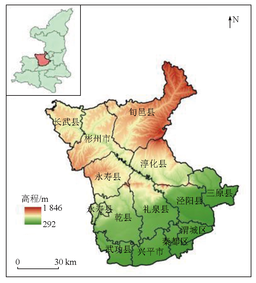
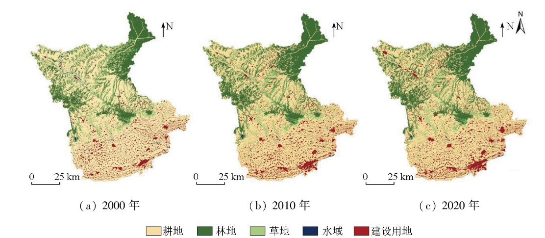
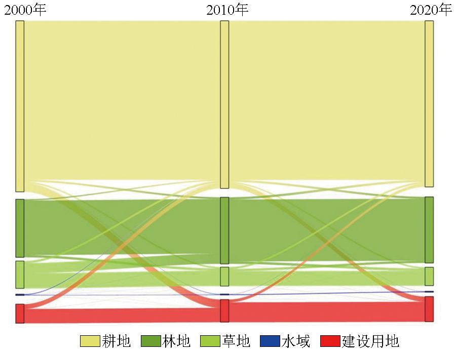
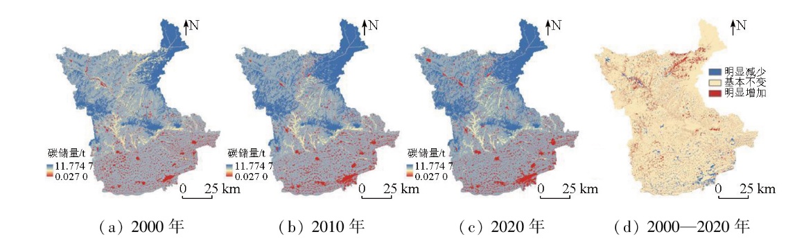
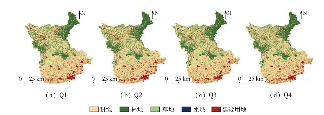
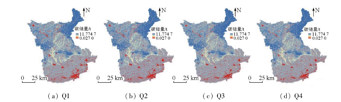
Land use change is a primary driver of carbon storage changes in terrestrial ecosystems. Investigating its impact on carbon storage is crucial for optimizing territorial spatial planning and reducing regional carbon emissions. Focusing on Xianyang City,this study analyzed changes in land use and carbon storage over the past two decades (2000—2020) based on corresponding land-use data from 2000,2010,and 2020,using the patch-generating land use simulation (PLUS) and integrated valuation of ecosystem services and tradeoffs (InVEST) models. Moreover,it predicted the distribution of carbon storage in 2030 under four scenarios:natural growth,urban development,cropland protection,and ecological protection. The results indicate that in 2000,2010,and 2020,Xianyang City exhibited carbon storage of 10 047.534×10⁴ t,10 120.754×10⁴ t,and 10 030.210×10⁴ t,respectively,characterized by a pattern of an initial increase followed by a decrease. The conversion of grassland to forest and cropland to construction land was identified as the main factor contributing to the increase and decrease in carbon storage,respectively. Among the four scenarios for 2030,cropland protection and ecological protection scenarios displayed increased carbon storage,while the urban development scenario experienced the most significant decline in carbon storage due to the rapid expansion of construction land. Areas with high carbon storage were mainly concentrated in northern Xianyang,whereas those with low carbon storage were distributed in the southern economic centers. Looking ahead,the future planning in Xianyang should fully consider the impacts of land use on carbon storage,ecological land protection,and restriction of extensive construction land expansion. By doing so,the city can achieve dual optimization of land use and carbon emissions. The findings provide a scientific basis and data reference for enhancing ecosystem carbon sink capacity and optimizing terrestrial spatial planning in Xianyang City.
陈秋计, 谢米米, 南丹丹, 罗豪. 基于PLUS-InVEST模型的咸阳市生态系统碳储量时空演变与预测[J]. 自然资源遥感, 2025, 37(5): 172-182.
CHEN Qiuji, XIE Mimi, NAN Dandan, LUO Hao. Spatiotemporal evolution and prediction of ecosystem carbon storage in Xianyang City based on the PLUS-InVEST model. Remote Sensing for Natural Resources, 2025, 37(5): 172-182.
Xi F, Lin G, Zhao Y, et al. Land use optimization and carbon storage estimation in the Yellow River Basin,China[J]. Sustainability, 2023, 15(14):11278.
Sun F H, Fang F M, Hong W L, et al. Evolution analysis and prediction of carbon storage in Anhui Province based on PLUS and InVEST model[J]. Journal of Soil and Water Conservation, 2023, 37(1):151-158.
[3]
Chang X Q, Xing Y Q, Wang J Q, et al. Effects of land use and cover change (LUCC) on terrestrial carbon stocks in China between 2000 and 2018[J]. Resources,Conservation and Recycling,2022,182:106333.
Zhang P, Li L T, Su Y J, et al. Spatial and temporal distribution characteristics of carbon storage in Handan City based on PLUS and InVEST models[J]. Bulletin of Soil and Water Conservation, 2023, 43(3):338-348.
[5]
Xu C L, Zhang Q B, Yu Q, et al. Effects of land use/cover change on carbon storage between 2000 and 2040 in the Yellow River Basin,China[J]. Ecological Indicators,2023, 151:110345.
[6]
Li Z, Tang Q, Wang X, et al. Grassland carbon change in northern China under historical and future land use and land cover change[J]. Agronomy, 2023, 13(8):2180.
Liu X J, Li X, Liang X, et al. Simulating the change of terrestrial carbon storage in China based on the FLUS-InVEST model[J]. Tropical Geography, 2019, 39(3):397-409.
doi: 10.13284/j.cnki.rddl.003138
Zhu W B, Zhang J J, Cui Y P, et al. Assessment of territorial ecosystem carbon storage based on land use change scenario:A case study in Qihe River Basin[J]. Acta Geographica Sinica, 2019, 74(3):446-459.
Xie Y J, Shen Z P, Zhao J. Evaluation of ecosystem carbon storage in Xuzhou City based on land use change scenarios[J]. Territory & Natural Resources Study, 2022(4):13-21.
Wang C Y, Guo X H, Guo L, et al. Land use change and its impact on carbon storage in Northwest China based on FLUS-InVEST:A case study of Hu-Bao-Er-Yu urban agglomeration[J]. Ecology and Environmental Sciences, 2022, 31(8):1667-1679.
[11]
Odebiri O, Mutanga O, Odindi J, et al. Evaluation of projected soil organic carbon stocks under future climate and land cover changes in South Africa using a deep learning approach[J]. Journal of Environmental Management, 2023, 330:117127.
Zhu Z Q, Ma X S, Hu H. Spatio-temporal evolution and prediction of ecosystem carbon stocks in Guangzhou City by coupling FLUS-InVEST models[J]. Bulletin of Soil and Water Conservation, 2021, 41(2):222-229,239.
Yu W H, Xu Z Y, Chen C S, et al. Analysis and prediction of the urban expansion of Jixi City based on logistic regression cellular automate model[J]. Geomatics & Spatial Information Technology, 2022, 45(1):45-49,54.
[14]
Wang Q Z, Guan Q Y, Sun Y F, et al. Simulation of future land use/cover change (LUCC) in typical watersheds of arid regions under multiple scenarios[J]. Journal of Environmental Management, 2023, 335:117543.
Gao Z B, Wang X R, Sui X Y, et al. Multi-scenario prediction of habitat quality in Nanjing based on FLUS and InVEST models[J]. Journal of Agricultural Resources and Environment, 2022, 39(5):1001-1013.
Wu D, Zhu K W, Zhang S, et al. Evolution analysis of carbon stock in Chengdu-Chongqing Economic Zone based on PLUS model and InVEST model[J]. Ecology and Environmental Monitoring of Three Gorges, 2022, 7(2):85-96.
[17]
Liang X, Guan Q F, Clarke K C, et al. Understanding the drivers of sustainable land expansion using a patch-generating land use simulation (PLUS) model:A case study in Wuhan,China[J]. Computers,Environment and Urban Systems, 2021, 85:101569.
[18]
Wang Z Y, Li X, Mao Y T, et al. Dynamic simulation of land use change and assessment of carbon storage based on climate change scenarios at the city level:A case study of Bortala,China[J]. Ecological Indicators, 2022, 134:108499.
Li J, Wang J, Li L, et al. Impact of land use change on carbon storage in the Dongting Lake Eco-economic Zone[J]. Chinese Journal of Ecology, 2022, 41(6):1156-1165.
doi: DOI: 10.13292/j.1000-4890.202206.026
Zhang P P, Li Y H, Yin H R, et al. Spatio-temporal variation and dynamic simulation of ecosystem carbon storage in the north-south transitional zone of China[J]. Journal of Natural Resources, 2022, 37(5):1183-1197.
Li J, Yang D H, Wu F Z, et al. Dynamic simulation of land use changes and assessment of carbon storage in Kunming City based on PLUS and InVEST models[J]. Bulletin of Soil and Water Conservation, 2023, 43(1):378-387.
Hou J K, Chen J J, Zhang K Q, et al. Temporal and spatial variation characteristics of carbon storage in the source region of the Yellow River based on InVEST and GeoSoS-FLUS models and its response to different future scenarios[J]. Environmental Science, 2022, 43(11):5253-5262.
[23]
Li K M, Cao J J, Adamowski J F, et al. Assessing the effects of ecological engineering on spatiotemporal dynamics of carbon storage from 2000 to 2016 in the Loess Plateau area using the InVEST model:A case study in Huining County,China[J]. Environmental Development,2021, 39:100641.
Sun X X, Xue J H, Dong L N. Spatiotemporal change and prediction of carbon storage in Nanjing ecosystem based on PLUS model and InVEST model[J]. Journal of Ecology and Rural Environment, 2023, 39(1):41-51.
Yang J. Simulation of land use change and carbon stock estimation in the Yellow River Basin based on FLUS-InVEST model[D]. Zhengzhou: Henan University, 2023.
[26]
岳程瑜. 陕西省森林碳储量及其碳汇潜力估算研究[D]. 杨凌: 西北农林科技大学, 2023.
Yue C Y. Estimation study of forest carbon storage and carbon sequestration potential in Shaanxi Province[D]. Yangling: Northwest A & F University, 2023.
Gu Z W, Liu J, Chen Y, et al. Analysis and simulation of the spatiotemporal evolution of habitat quality and carbon storage in the Weibei Dry Plateau Region of Shaanxi[J]. Environmental Science, 2023, 44(8):4666-4678.
Duan B Z, Shi H, Wei X F, et al. Surface soil carbon storage and distribution in Xi’an City[J]. Bulletin of Soil and Water Conservation, 2016, 36(6):293-297.
Wang X C. Evolution of ecosystem services of Weihe River Basin in Shaanxi Qinling Mountain based on InVEST model[D]. Xi’an: Northwest University, 2022.
Zhang B, Xia Q Y, Dong J, et al. Research on the impact of land use change on the spatio-temporal pattern of carbon storage in metropolitan suburbs:Taking Huangpi District of Wuhan City as an example[J]. Journal of Ecology and Rural Environment, 2023, 39(6):699-712.
Yang L W, Zhao J, Zhu J T, et al. Spatial-temporal change and prediction of carbon stock in the ecosystem of Xi’an based on PLUS and InVEST models[J]. Remote Sensing for Natural Resources, 2022, 34(4):175-182.doi:10.6046/zrzyyg.2021348.
Wang J N, Zhang Z. Land use change and simulation analysis in the northern margin of the Qaidam Basin based on Markov-PLUS model[J]. Journal of Northwest Forestry University, 2022, 37(3):139-148,179.
Hu F, Zhang Y, Guo Y, et al. Spatial and temporal changes in land use and habitat quality in the Weihe River Basin based on the PLUS and InVEST models and predictions[J]. Arid Land Geography, 2022, 45(4):1125-1136.
doi: 10.12118/j.issn.1000-6060.2021.510
Luo S Q, Hu X M, Sun Y, et al. Multi-scenario land use change and its impact on carbon storage based on coupled Plus-InVEST model[J]. Chinese Journal of Eco-Agriculture, 2023, 31(2):300-314.
Jiang M. Study on the spatiotemporal variation and asscoiated driving factors of ecosystem services in the southwest karst of China[D]. Wuhan: Huazhong Agricultural University, 2022.
[36]
Chen H, Dong N, Liang X, et al. Spatiotemporal evaluation of regional land use dynamics and its potential ecosystem impact under carbon neutral pathways in the Guangdong-Hong Kong-Macao Greater Bay Area,China[J]. Remote Sensing, 2023, 15(24):5749.
Wang C W, Luo J J, Tang H H. Analysis on the driving force of spatial and temporal differentiation of carbon storage in the Taihang Mountains based on InVEST model[J]. Ecology and Environmental Sciences, 2023, 32(2):215-225.
 2025, Vol. 37
  ), 谢米米(