Landslide detection in complex environments based on dual feature fusion
FANG Liuyang1,2,3(), YANG Changhao1, SHU Dong1, YANG Xuekun2,3, CHEN Xingtong2,3, JIA Zhiwen1
1. Faculty of Land Resources Engineering,Kunming University of Science and Technology,Kunming 650093,China 2. Broadvision Engineering Consultants,Kunming 650200,China 3. Yunnan Key Laboratory of Digital Communications,Kunming 650000,China
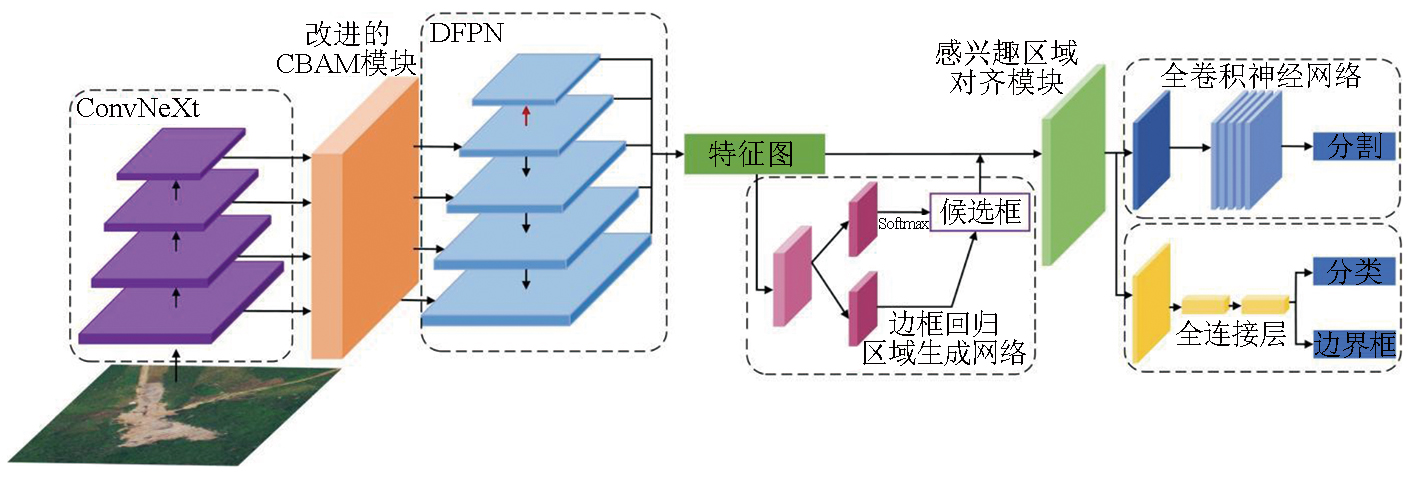
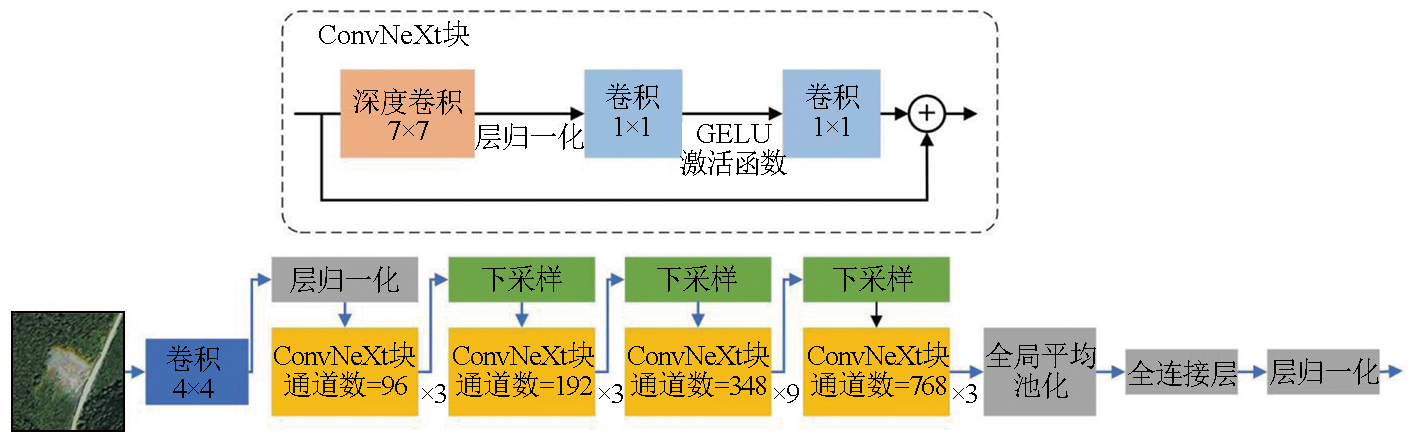
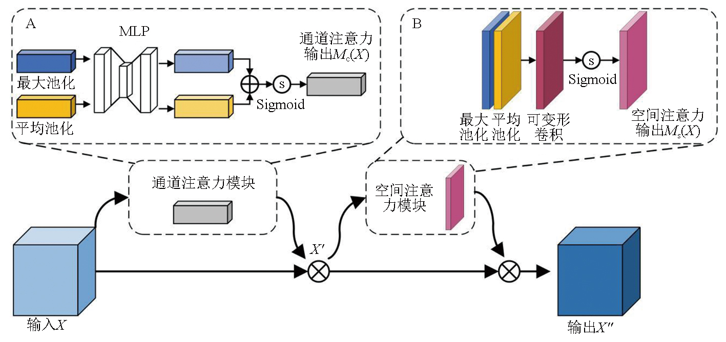
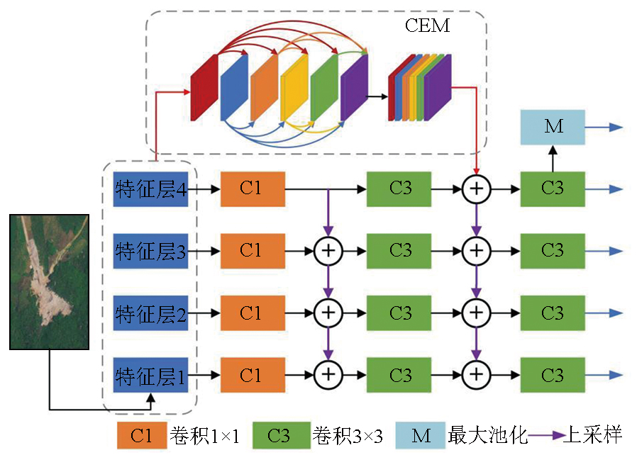
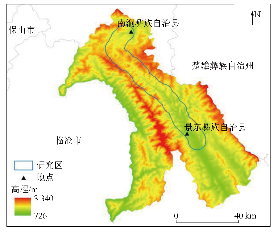
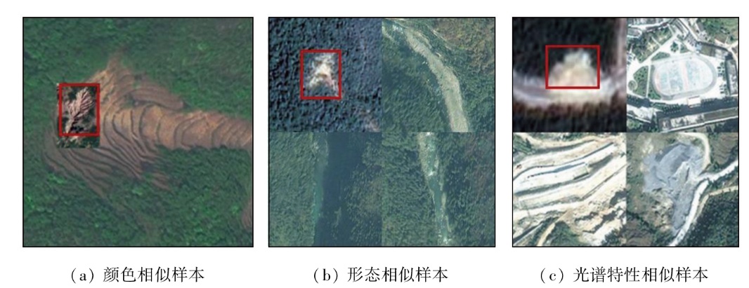
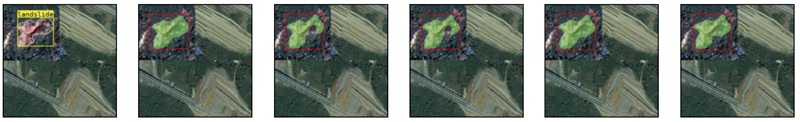
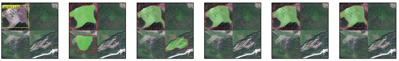
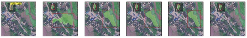
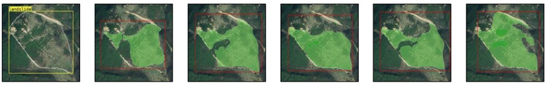
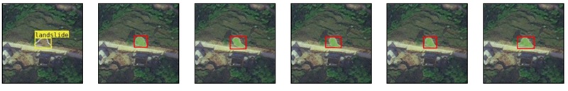
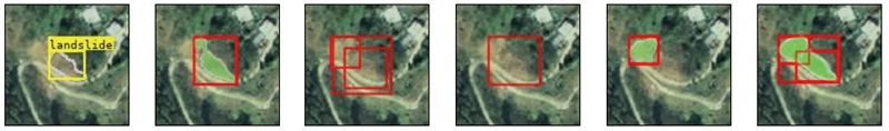
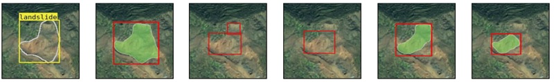
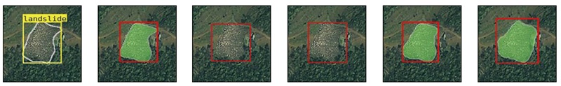
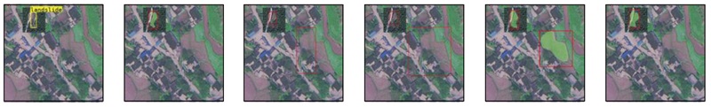
Landslide disasters are frequent and widespread in southwestern China. The accurate identification and mapping of landslides using remote sensing imagery are of great significance for disaster prevention and mitigation. However,in complex environments,traditional remote sensing detection methods are often prone to misidentification due to background noise in the imagery. This paper proposed a dual-fusion landslide detection network (DLDNet) to improve landslide detection accuracy under challenging conditions. First,based on existing landslide samples,landslide simulation was conducted in complex environments using data augmentation techniques. Second,the ConvNeXt was adopted as the feature extraction backbone of DLDNet to capture more complex landslide features. Then,an attention module enhanced with deformable convolution was introduced to better focus on landslide-related information. Finally,a dual-fusion feature pyramid network (DFPN) was designed to thoroughly integrate feature information across different scales and receptive fields. The experimental results show that the proposed DLDNet achieved average precision (AP) scores of 56.9% for bounding box detection and 52.5% for segmentation,10.4 and 10.7 percentage points higher than those of the baseline model (Mask R-CNN). Compared with other landslide detection models,the DLDNet demonstrates higher detection accuracy and a lower false alarm rate. The method,characterized by accurate landslide detection in complex environments,can support rapid landslide identification and emergency response.
Tie Y B, Ge H, Gao Y C, et al. The research progress and prospect of geological hazards in Southwest China since the 20th Century[J]. Sedimentary Geology and Tethyan Geology, 2022, 42(4):653-665.
Cai J A, Ming D P, Zhao W Y, et al. Integrated remote sensing-based hazard identification and disaster-causing mechanisms of landslides in Zayu County[J]. Remote Sensing for Natural Resources, 2024, 36(1):128-136.doi:10.6046/zrzyyg.2023313.
[3]
晏同珍, 杨顺安, 方云. 滑坡学[M]. 武汉: 中国地质大学出版社, 2000.
Yan T Z, Yang S A, Fang Y. Landslidologies[M]. Wuhan: China University of Geosciences Press, 2000.
[4]
Fan J R, Zhang X Y, Su F H, et al. Geometrical feature analysis and disaster assessment of the Xinmo landslide based on remote sensing data[J]. Journal of Mountain Science, 2017, 14(9):1677-1688.
Li Q, Zhang J F, Luo Y, et al. Recognition of earthquake-induced landslide and spatial distribution patterns triggered by the Jiuzhaigou earthquake in August 8,2017[J]. Journal of Remote Sensing, 2019, 23(4):785-795.
[6]
Sato H P, Hasegawa H, Fujiwara S, et al. Interpretation of landslide distribution triggered by the 2005 Northern Pakistan earthquake using SPOT 5 imagery[J]. Landslides, 2007, 4(2):113-122.
[7]
Lu P, Qin Y, Li Z, et al. Landslide mapping from multi-sensor data through improved change detection-based Markov random field[J]. Remote Sensing of Environment, 2019, 231:111235.
Li C H, Hao L N, Xu Q, et al. Object-oriented hierarchical identification of earthquake-induced landslides based on high-resolution remote sensing images[J]. Remote Sensing for Natural Resources, 2023, 35(1):74-80.doi:10.6046/zrzyyg.2022013.
Li Q L, Zhang W C, Yi Y N. An information extraction method of earthquake-induced landslide:A case study of the Jiuzhaigou earthquake in 2017[J]. Journal of University of Chinese Academy of Sciences, 2020, 37(1):93-102.
Zhang Y, Ming D P, Zhao W Y, et al. The extraction and analysis of Luding earthquake-induced landslide based on high-resolution optical satellite images[J]. Remote Sensing for Natural Resources, 2023, 35(1):161-170.doi:10.6046/zrzyyg.2022434.
[11]
Liang R, Dai K, Shi X, et al. Automated mapping of ms 7.0 Jiu-zhaigou earthquake (China) post-disaster landslides based on high-resolution UAV imagery[J]. Remote Sensing, 2021, 13(7):1330.
Guo A Q, Hu J, Zheng W J, et al. N-BEATS deep learning method for landslide deformation monitoring and prediction based on InSAR:A case study of Xinpu landslide[J]. Acta Geodaetica et Cartographica Sinica, 2022, 51(10):2171-2182.
Jiang W D, Xi J B, Li Z H, et al. Landslide detection and segmentation using Mask R-CNN with simulated hard samples[J]. Geomatics and Information Science of Wuhan University, 2023, 48(12):1931-1942.
Bai S, Tang P P, Miao Z, et al. Information extraction of landslides based on high-resolution remote sensing images and an improved U-Net model:A case study of Wenchuan,Sichuan[J]. Remote Sensing for Natural Resources, 2024, 36(3):96-107.doi:10.6046/zrzyyg.2023132.
[15]
Cortes C, Vapnik V. Support-vector networks[J]. Machine Lear-ning, 1995, 20(3):273-297.
[16]
Breiman L. Random forests[J]. Machine Learning, 2001, 45:5-32.
[17]
Khelifi L, Mignotte M. Deep learning for change detection in remote sensing images:Comprehensive review and meta-analysis[J]. IEEE Access, 2020, 8:126385-126400.
Liu J, Wu Y M, Gao X, et al. Image recognition of co-seismic landslide based on GEE and U-net neural network[J]. Journal of Geo-Information Science, 2022, 24(7):1275-1285.
Yang Z Y, Han L Y, Zheng X X, et al. Landslide identification using remote sensing images and DEM based on convolutional neural network:A case study of loess landslide[J]. Remote Sensing for Natural Resources, 2022, 34(2):224-230.doi:10.6046/zrzyyg.2021204.
[20]
Yu Z, Chang R, Chen Z. Automatic detection method for loess landslides based on GEE and an improved YOLOX algorithm[J]. Remote Sensing, 2022, 14(18):4599.
[21]
Yang R, Zhang F, Xia J, et al. Landslide extraction using mask R-CNN with background-enhancement method[J]. Remote Sensing, 2022, 14(9):2206.
Tang X C, Tu Z H, Ren X Q, et al. A multi-modal deep neural network model for forested landslide detection[J]. Geomatics and Information Science of Wuhan University, 2024, 49(9):1566-1573.
Jiang W J, Zhang C J, Xu B, et al. AED-net:Semantic segmentation model for landslide recognition from remote sensing images[J]. Journal of Geo-Information Science, 2023, 25(10):2012-2025.
[24]
Ji S, Yu D, Shen C, et al. Landslide detection from an open satellite imagery and digital elevation model dataset using attention boosted convolutional neural networks[J]. Landslides, 2020, 17(6):1337-1352.
[25]
He K, Gkioxari G, Dollár P, et al. Mask R-CNN[C]//2017 IEEE International Conference on Computer Vision (ICCV). IEEE, 2017:2980-2988.
[26]
Woo S, Park J, Lee J Y, et al. CBAM:Convolutional block attention module[M]//Lecture Notes in Computer Science. Cham: Springer International Publishing,2018:3-19.
[27]
Liu Z, Mao H, Wu C Y, et al. A ConvNet for the 2020s[C]//2022 IEEE/CVF Conference on Computer Vision and Pattern Recognition (CVPR). IEEE, 2022:11966-11976.
Fu G D, Huang J, Yang T, et al. Improved lightweight attention model based on CBAM[J]. Computer Engineering and Applications, 2021, 57(20):150-156.
doi: 10.3778/j.issn.1002-8331.2101-0369
[29]
Lin T Y, Dollár P, Girshick R, et al. Feature pyramid networks for object detection[C]//2017 IEEE Conference on Computer Vision and Pattern Recognition (CVPR). IEEE, 2017:936-944.
[30]
Cao J, Chen Q, Guo J, et al. Attention-guided context feature pyramid network for object detection[J/OL]. arXiv, 2020:2005.11475. https://arxiv.org/abs/2005.11475v1.
[31]
Yun S, Han D, Chun S, et al. CutMix:Regularization strategy to train strong classifiers with localizable features[C]//2019 IEEE/CVF International Conference on Computer Vision (ICCV). IEEE, 2019:6022-6031.
[32]
Bochkovskiy A, Wang C Y, Liao H Y M. YOLOv4:Optimal speed and accuracy of object detection[J/OL]. arXiv, 2020:2004.10934. https://arxiv.org/abs/2004.10934v1.
 2025, Vol. 37
  ), 杨昌浩1, 舒东1, 杨学昆2,3, 陈兴通2,3, 贾志文1