Change detection network for dual-temporal optical remote sensing images integrating fast Fourier transform and efficient multi-head self-attention
WANG Xingwei1(), TANG Kangqi2(), LIU Yan3, LIU Huan4
1. China Railway Siyuan Survey and Design Group Co.,Ltd.,Wuhan 430063,China 2. College of Earth and Planetary Sciences,Chengdu University of Technology,Chengdu 610059,China 3. College of Geography and Planning,Chengdu University of Technology,Chengdu 610059,China 4. Sichuan Anxin Kechuang Technology Co.,Ltd.,Chengdu 610045,China
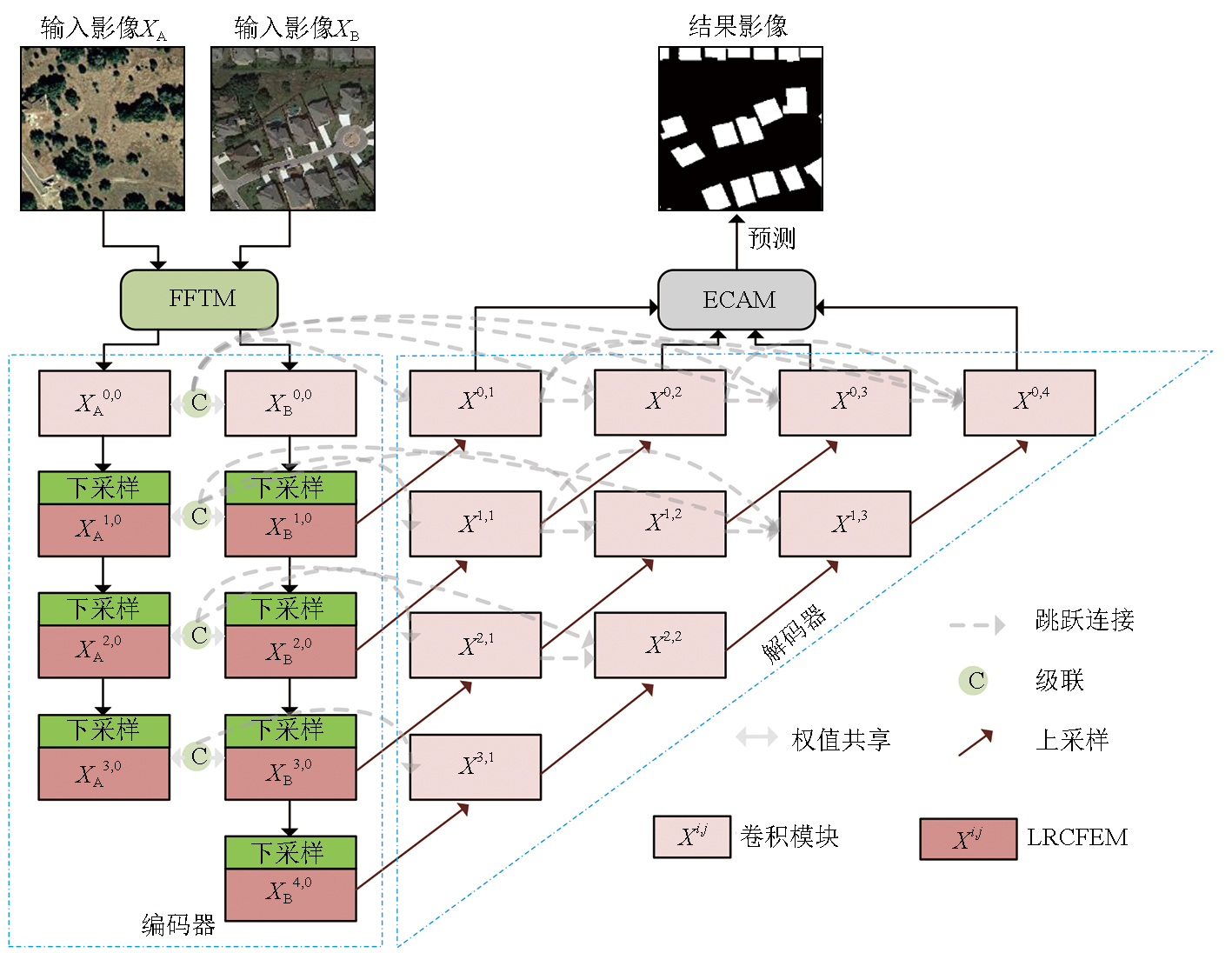
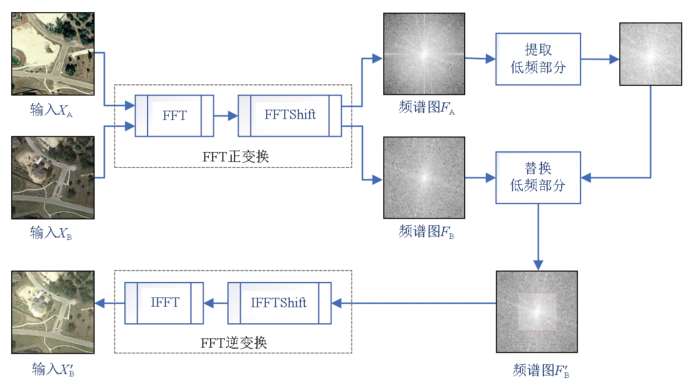
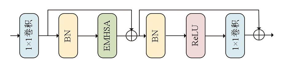
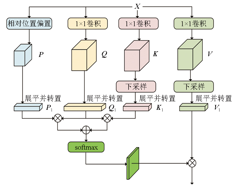
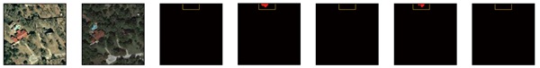
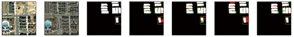
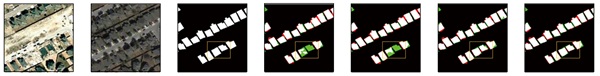
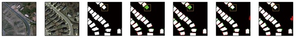
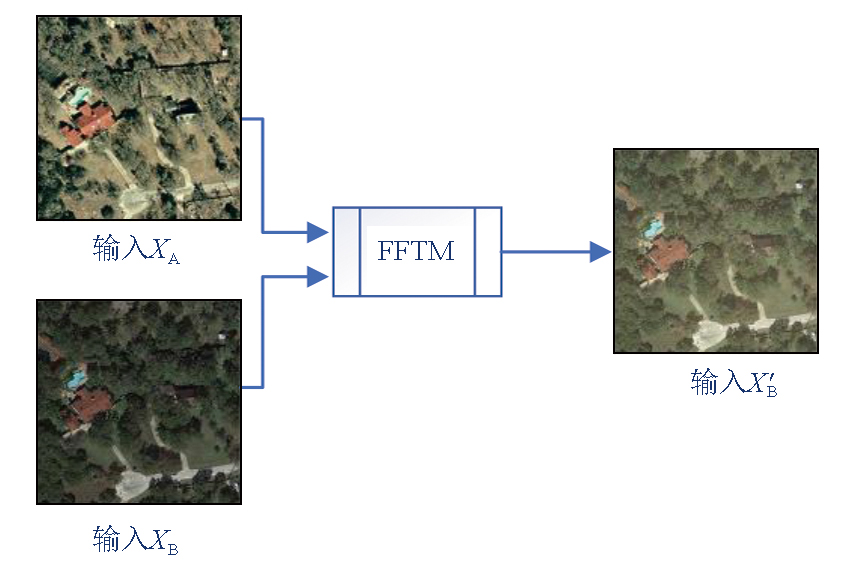
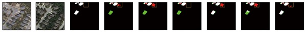
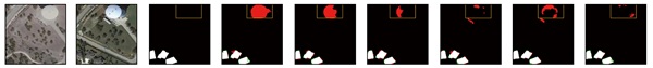
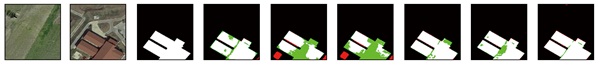
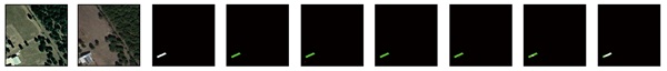
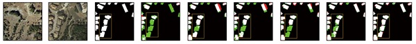
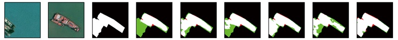
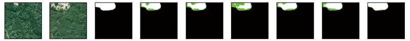
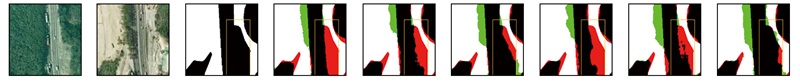
The deep learning-based change detection of remote sensing images has seen rapid advances in the past few years. However,it still faces challenges for change detection in complex scenes,such as incomplete recognition and high false detection rates. In response to these challenges,this paper proposed the FTUNet,a network based on SNUnet that integrates the fast Fourier transform (FFT) and efficient multi-head self-attention (EMHSA). Specifically,the FFT module in the network enabled style unification of dual-temporal images,reducing false detection caused by “pseudo changes” due to external factors such as light variations. Additionally,the EMHSA was introduced in the feature extraction stage to fully extract the contextual information from the feature maps,thereby enhancing the segmentation integrity of target changes. Experiments on the LEVIR-CD and SYSU-CD public datasets showed that the FTUNet exhibited increases of 1.42 and 1.53 percentage points in F1 score,as well as increases of 2.31 and 2.07 percentage points in intersection over union (IoU),compared to the SNUNet.
Bruzzone L, Bovolo F. A novel framework for the design of change-detection systems for very-high-resolution remote sensing images[C]// Proceedings of the IEEE.July 24, 2012, IEEE, 2013:609-630.
[2]
Zhu Q Q, Guo X, Deng W H, et al. Land-use/land-cover change detection based on a Siamese global learning framework for high spatial resolution remote sensing imagery[J]. ISPRS Journal of Photogrammetry and Remote Sensing, 2022, 184:63-78.
[3]
Lv Z Y, Liu T F, Benediktsson J A, et al. Land cover change detection techniques:Very-high-resolution optical images:A review[J]. IEEE Geoscience and Remote Sensing Magazine, 2022, 10(1):44-63.
[4]
Wen D W, Huang X, Bovolo F, et al. Change detection from very-high-spatial-resolution optical remote sensing images:Methods,applications,and future directions[J]. IEEE Geoscience and Remote Sensing Magazine, 2021, 9(4):68-101.
[5]
Bhatt A, Ghosh S K, Kumar A. Spectral indices based object oriented classification for change detection using satellite data[J]. International Journal of System Assurance Engineering and Management, 2018, 9(1):33-42.
[6]
Atasever U H, Kesikoglu M H, Ozkan C. A new artificial intelligence optimization method for pca based unsupervised change detection of remote sensing image data[J]. Neural Network World, 2016, 26(2):141-154.
[7]
Nagne A D, Vibhute A D, Dhumal R K, et al. Urban LULC change detection and mapping spatial variations of Aurangabad City using IRS LISS-III temporal datasets and supervised classification approach[M]//Data Analytics and Learning. Singapore: Springer Singapore,2018:369-386.
[8]
Zhang X F, Cheng S L, Wang L J, et al. Asymmetric cross-attention hierarchical network based on CNN and Transformer for bitemporal remote sensing images change detection[J]. IEEE Transactions on Geoscience and Remote Sensing, 2023, 61:2000415.
[9]
Fang S, Li K Y, Shao J Y, et al. SNUNet-CD:A densely connected Siamese network for change detection of VHR images[J]. IEEE Geoscience and Remote Sensing Letters, 2021, 19:8007805.
[10]
Daudt R C, Le Saux B, Boulch A. Fully convolutional Siamese networks for change detection[C]//2018 25th IEEE International Conference on Image Processing (ICIP). October 7-10,2018.Athens. IEEE, 2018:4063-4067.
[11]
Chen H, Shi Z W. A spatial-temporal attention-based method and a new dataset for remote sensing image change detection[J]. Remote Sensing, 2020, 12(10):1662.
[12]
Zhang C X, Yue P, Tapete D, et al. A deeply supervised image fusion network for change detection in high resolution bi-temporal remote sensing images[J]. ISPRS Journal of Photogrammetry and Remote Sensing, 2020, 166:183-200.
[13]
Zhou Z W, Rahman Siddiquee M M, Tajbakhsh N, et al. UNet++:A nested U-Net architecture for medical image segmentation[M]//Deep Learning in Medical Image Analysis and Multimodal Learning for Clinical Decision Support. Cham: Springer Internatio-nal Publishing,2018:3-11.
[14]
Chen H, Qi Z P, Shi Z W. Remote sensing image change detection with Transformers[J]. IEEE Transactions on Geoscience and Remote Sensing, 2021, 60:5607514.
[15]
Feng Y C, Jiang J W, Xu H H, et al. Change detection on remote sensing images using dual-branch multilevel intertemporal network[J]. IEEE Transactions on Geoscience and Remote Sensing, 2023, 61:4401015.
[16]
Zhang R Q, Zhang H C, Ning X G, et al. Global-aware Siamese network for change detection on remote sensing images[J]. ISPRS Journal of Photogrammetry and Remote Sensing, 2023, 199:61-72.
Song J X, Li Y K, Yang S W, et al. NSCT-based change detection for high-resolution remote sensing images under the framework of change vector analysis in posterior probability space[J]. Remote Sensing for Natural Resources, 2024, 36(3):128-136.doi:10.6046/zrzyyg.2023079.
Chai J X, Zhang Y S, Yang Z, et al. Multi-level building change detection based on the DSM and DOM generated from UAV images[J]. Remote Sensing for Natural Resources, 2024, 36(2):80-88.doi:10.6046/zrzyyg.2023001.
Ma H, Liu B, Du S H. Multi-class change detection using a multi-task Siamese network of remote sensing images[J]. Remote Sensing for Natural Resources, 2024, 36(1):77-85.doi:10.6046/zrzyyg.2022446.
[20]
Duhamel P, Vetterli M. Fast Fourier transforms:A tutorial review and a state of the art[J]. Signal Processing, 1990, 19(4):259-299.
[21]
Gao Y H, Zhou M, Metaxas D N. UTNet:A hybrid transformer architecture for medical image segmentation[M]//Medical Image Computing and Computer Assisted Intervention-MICCAI 2021.Cham: Springer International Publishing,2021:61-71.
[22]
Shi Q, Liu M X, Li S C, et al. A deeply supervised attention metric-based network and an open aerial image dataset for remote sensing change detection[J]. IEEE Transactions on Geoscience and Remote Sensing, 2021, 60:5604816.
 2025, Vol. 37
  ), 唐康其2(