Landslide identification based on an improved YOLOv7 model: A case study of the Baige area
LIU Haoran1,2(), YAN Tianxiao1,2, ZHU Yueqin2(), WANG Yanping1, CHEN Zuyi1, YANG Zhaoying3, ZHU Haomeng4
1. Institute of Disaster Prevention Science and Technology, Langfang 065201, China 2. National Institute of Natural Disaster Prevention, Ministry of Emergency Management of China, Beijing 100085, China 3. China Aero Geophysical Survey and Remote Sensing Center, Beijing 100083, China 4. Zhejiang Institute of Geosciences, Hangzhou 310000, China
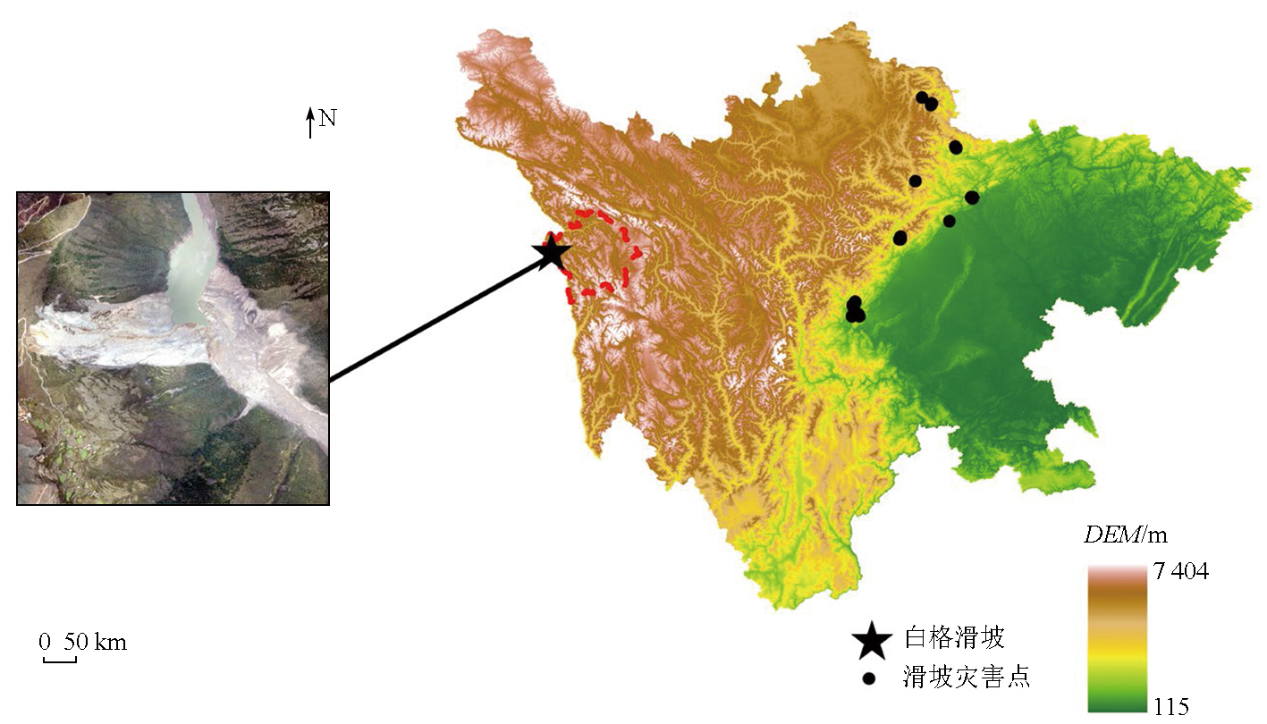
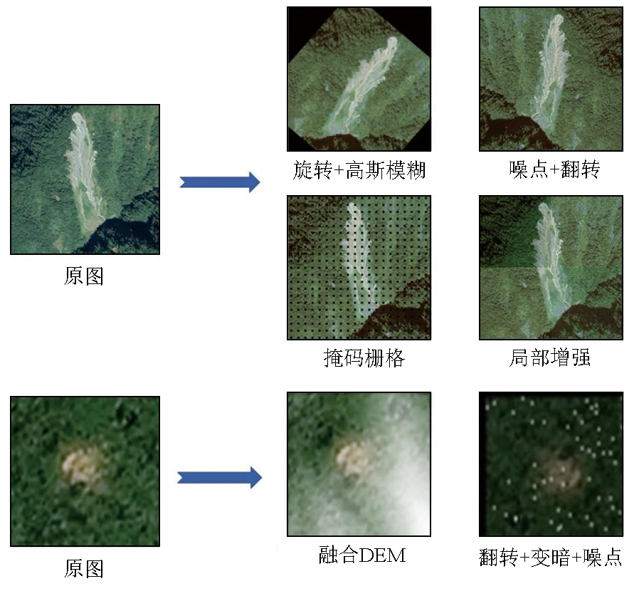
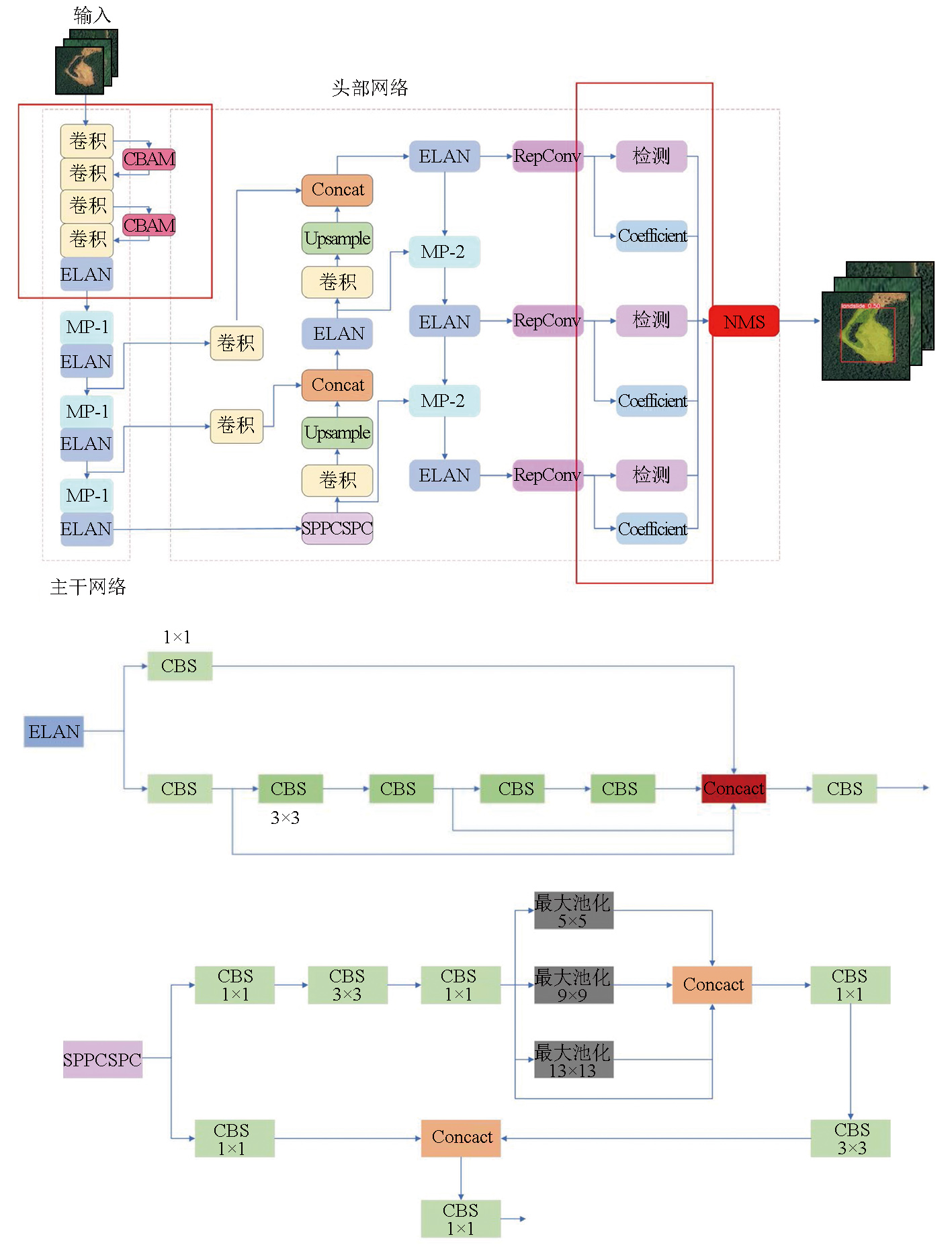
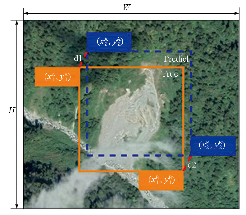
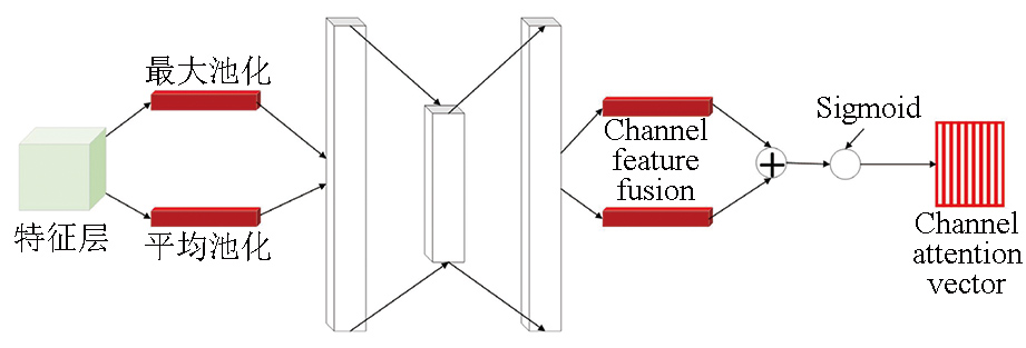
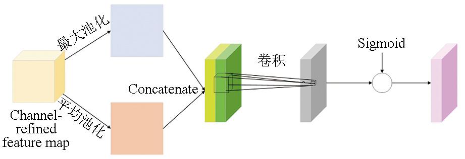
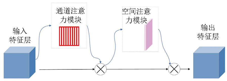
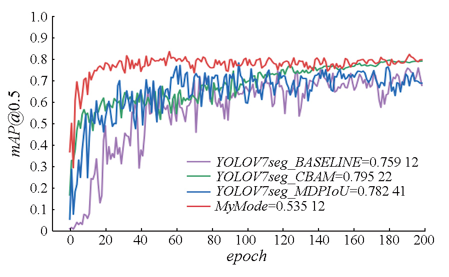
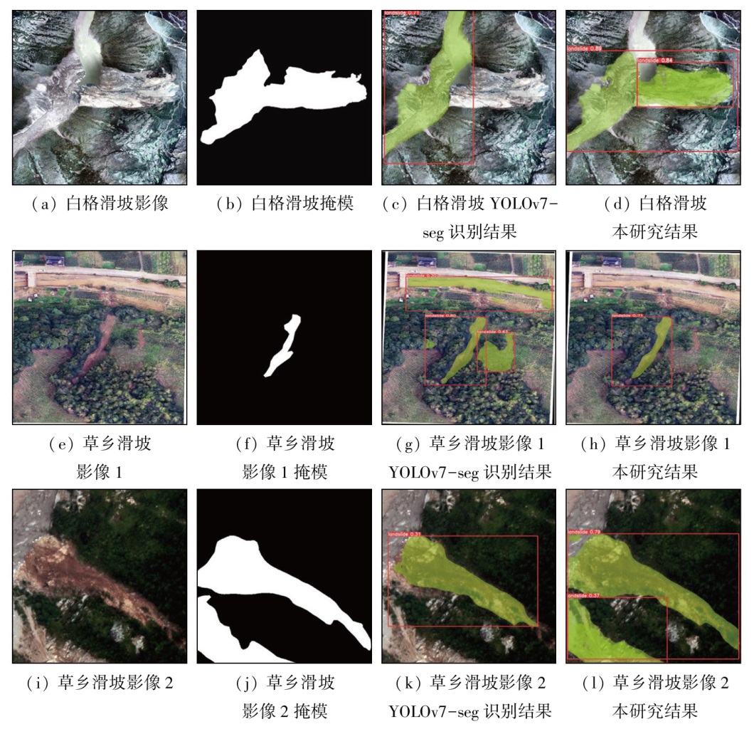
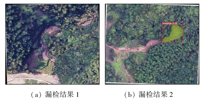
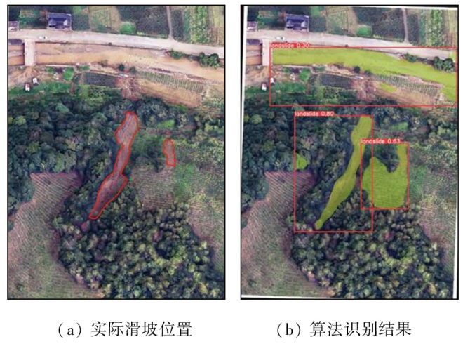
Landslide identification has always been a research topic in the study of geological disasters, playing a significant role in emergency rescue and command. To address the limitations in landslide identification, such as missed/false detection, and low identification accuracy, this study proposed an improved YOLOv7 model that enables simultaneous object detection and image segmentation for landslides. The improved model optimized its core network by integrating data, adding the convolutional block attention module (CBAM), and changing the intersection over union (IoU) loss function. Its effectiveness was verified using the landslide dataset of Bijie City, Guizhou Province, and the 0.2 m high-resolution digital orthophoto map (DOM) of historical landslides in Sichuan Province. The results indicate that the improved model performed well in landslide detection and segmentation, achieving more efficient and accurate landslide identification compared to the conventional YOLOv7 model, and other prevailing models like Fast RCNN and Mask RCNN. Taking the Baige area in Sichuan Province as an example, this model can effectively enhance the automation level of landslide disaster information acquisition while improving accuracy.
刘浩然, 严天笑, 朱月琴, 王艳萍, 陈祖谊, 杨昭颖, 朱浩濛. 基于一种改进YOLOv7算法模型的滑坡识别研究——以四川省白格地区为例[J]. 自然资源遥感, 2025, 37(4): 48-57.
LIU Haoran, YAN Tianxiao, ZHU Yueqin, WANG Yanping, CHEN Zuyi, YANG Zhaoying, ZHU Haomeng. Landslide identification based on an improved YOLOv7 model: A case study of the Baige area. Remote Sensing for Natural Resources, 2025, 37(4): 48-57.
Tan Y J, Liu R M, Zhu Y Q, et al. On the characteristics and development directions of geological big data[J]. Journal of Spatio-Temporal Information, 2023, 30(3):313-320.
Zhang X Y, Su Q M, Zhao C S, et al. A landslide susceptibility evaluation method using Bayesian algorithm to optimize XGBoost[J]. Science of Surveying and Mapping, 2023, 48(6):140-150.
Kang M Y, Zhu Y Q, Chen C, et al. Research on landslide sliding distance prediction model based on multiple nonlinear regression and BP neural network[J]. Geological Bulletin of China, 2022, 41(12):2281-2289.
Hong T, Zhu Y Q, Guo Y J, et al. Research on interactive geological scene model construction method based on XR technology[J]. Geological Bulletin of China, 2023, 42(s1):469-478.
[5]
Messeri A, Morabito M, Messeri G, et al. Weather-related flood and landslide damage:A risk index for Italian regions[J]. PLoS One, 2015, 10(12):e0144468.
[6]
Chigira M, Yagi H. Geological and geomorphological characteristics of landslides triggered by the 2004 Mid Niigta prefecture earthquake in Japan[J]. Engineering Geology, 2006, 82(4):202-221.
[7]
Nichol J, Wong M S. Satellite remote sensing for detailed landslide inventories using change detection and image fusion[J]. International Journal of Remote Sensing, 2005, 26(9):1913-1926.
[8]
Hang H T, Tung H, Hoa P D, et al. Spatial prediction of landslides along National Highway-6,Hoa Binh Province,Vietnam using novel hybrid models[J]. Geocarto International, 2022, 37(18):5201-5226.
doi: 10.1080/10106049.2021.1912195
[9]
Lei T, Zhang Y, Lyu Z, et al. Landslide inventory mapping from bitemporal images using deep convolutional neural networks[J]. IEEE Geoscience and Remote Sensing Letters, 2019, 16(6):982-986.
[10]
Ji S, Yu D, Shen C, et al. Landslide detection from an open satellite imagery and digital elevation model dataset using attention boosted convolutional neural networks[J]. Landslides, 2020, 17(6):1337-1352.
[11]
Barlow J, Martin Y, Franklin S E. Detecting translational landslide scars using segmentation of Landsat ETM+ and DEM data in the northern Cascade Mountains,British Columbia[J]. Canadian Journal of Remote Sensing, 2003, 29(4):510-517.
Yang Z Y, Han L Y, Zheng X X, et al. Landslide identification using remote sensing images and DEM based on convolutional neural network:A case study of loess landslide[J]. Remote Sensing for Natural Resources, 2022, 34(2):224-230.doi:10.6046/zrzyyg.2021204.
[13]
Ding A, Zhang Q, Zhou X, et al. Automatic recognition of landslide based on CNN and texture change detection[C]// 2016 31st Youth Academic Annual Conference of Chinese Association of Automation (YAC).November 11-13,2016,Wuhan,China.IEEE, 2016:444-448.
[14]
Wang C Y, Bochkovskiy A, Liao H Y M. YOLOv7:Trainable bag-of-freebies sets new state-of-the-art for real-time object detectors[EB/OL]. 2022: 2207.02696v1. https://arxiv.org/abs/2207.02696v1.
Zeng C, Cao Z Y, Su F H, et al. A dataset of high-precision aerial imagery and interpretation of landslide and debris flow disaster in Sichuan and surrounding areas between 2008 and 2020[J]. China Scientific Data, 2022, 7(2):195-205.
Huang Z, Zhu H B, Tao Y R. Rapid evaluation method of polished surface quality based on YOLOv5[J]. Intelligent Computer and Applications, 2022, 12(11):247-252.
Song M Y, Chen L R, Liang J A, et al. Real-time optical fiber end surface defects detection model based on lightweight improved network[J]. Laser and Optoelectronics Progress, 2022, 59(24):2415006.
[18]
He K, Gkioxari G, Dollár P, et al. Mask R-CNN[C]// 2017 IEEE International Conference on Computer Vision (ICCV).October 22-29,2017,Venice,Italy.IEEE, 2017: 2980-2988.
[19]
Jocher G. Yolov5[EB/OL].(2020-08-10)[2023-04-10]. https://github.com/ultralytics/yolo-v5.
[20]
Ren S, He K, Girshick R, et al. Faster R-CNN:Towards real-time object detection with region proposal networks[J]. IEEE Transactions on Pattern Analysis and Machine Intelligence, 2017, 39(6):1137-1149.
[21]
Bolya D, Zhou C, Xiao F, et al. YOLACT:Real-time instance segmentation[C]// 2019 IEEE/CVF International Conference on Computer Vision (ICCV).October 27 - November 2,2019,Seoul,Korea (South).IEEE, 2019: 9156-9165.
 2025, Vol. 37
  ), 严天笑1,2, 朱月琴2(