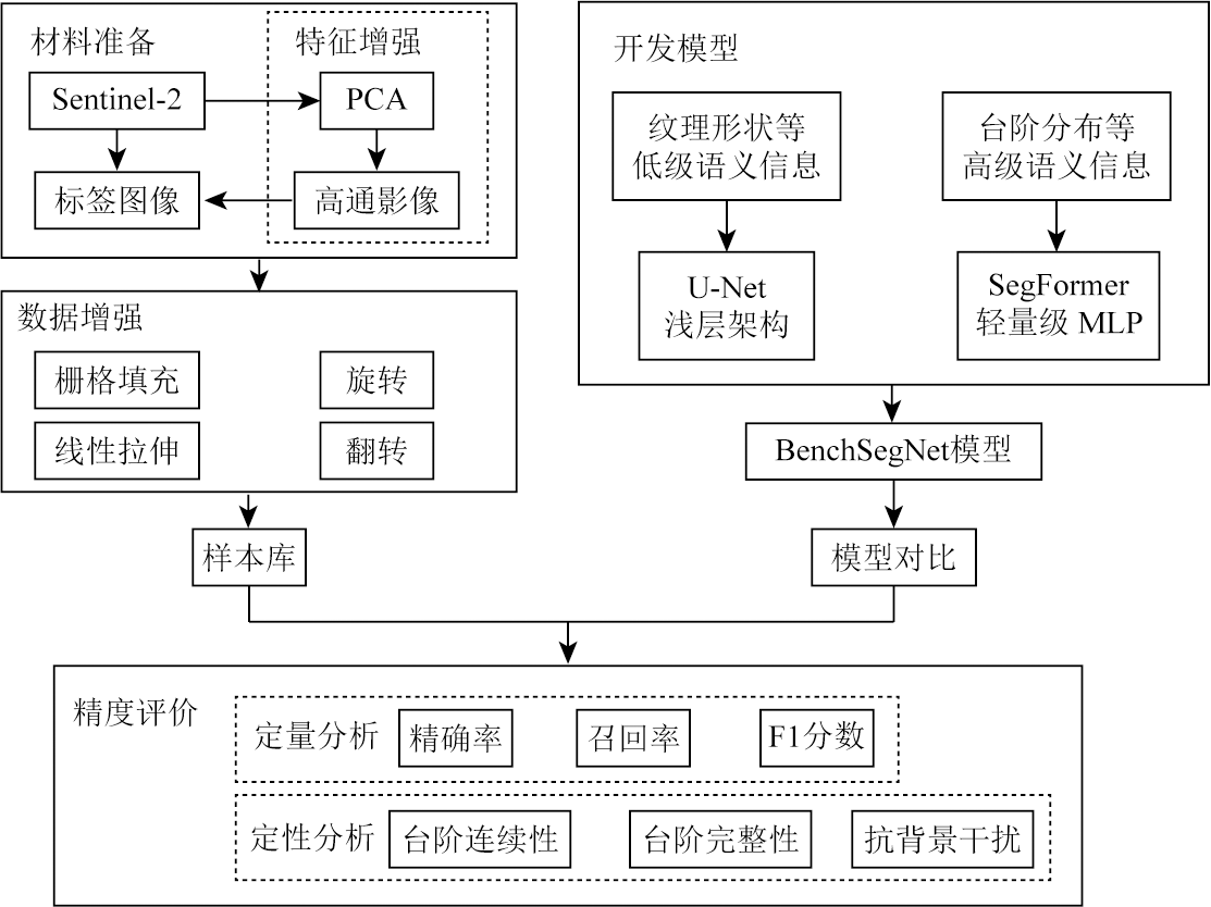
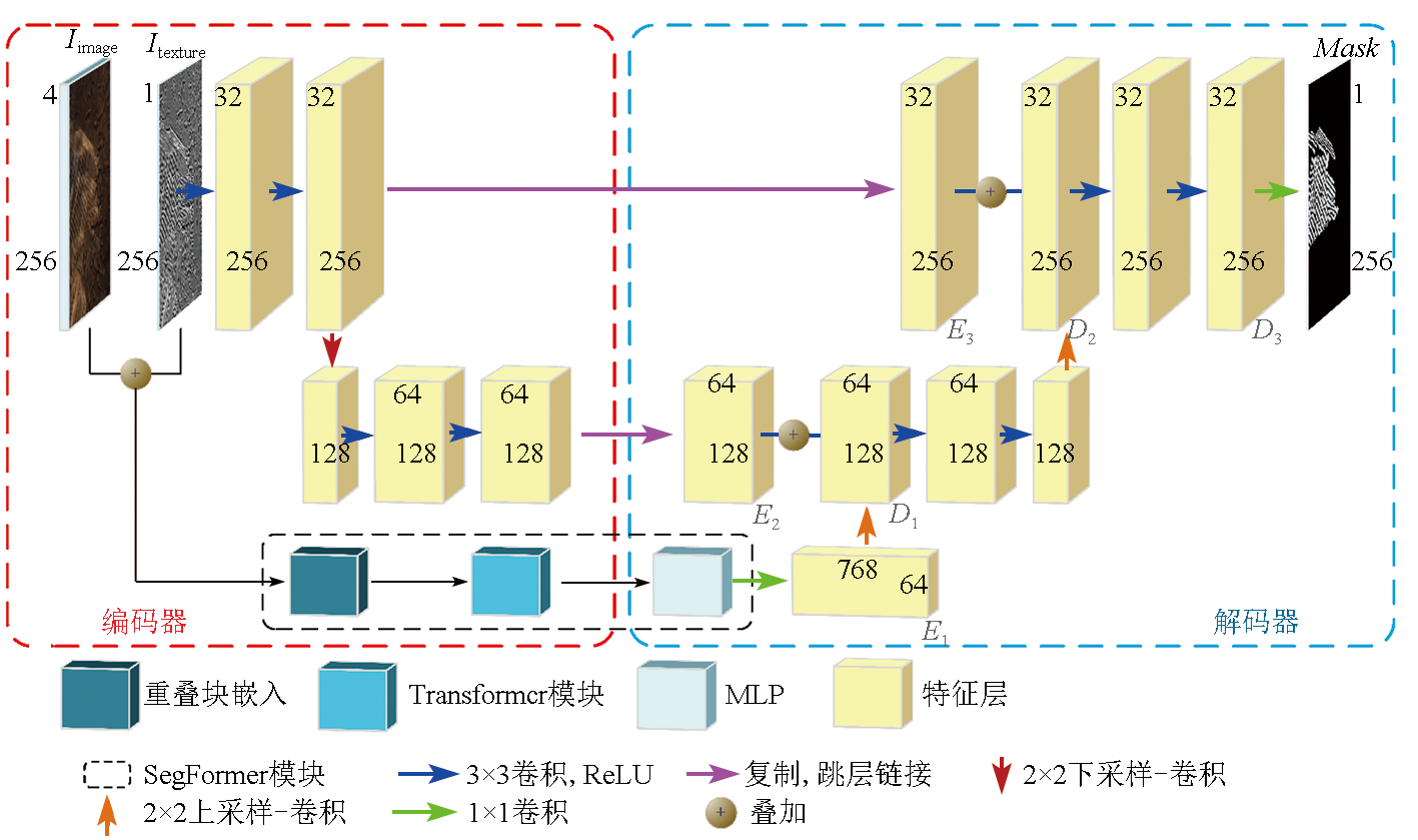
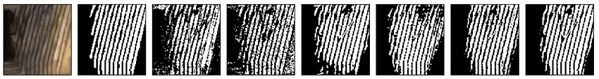
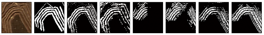
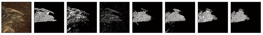
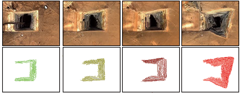
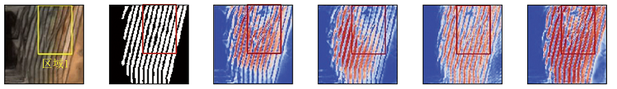
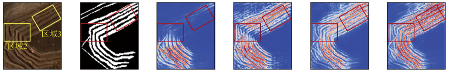
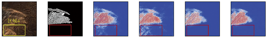
Benches, important surface features in open-pit coal mines, can reflect the production status in the mines. Extracting information about benches from remote sensing images can provide a significant basis for production monitoring in coal mines, as well as ecological protection and restoration. This study established the BenchSegNet deep learning model for extracting information on benches in open-pit coal mines from Sentinel-2 images. The results indicate that the BenchSegNet model inherited the strong generalization capability of SegFormer and the powerful detail extraction ability of U-Net, achieving an accuracy of 97.69%. Compared to the SegFormer model, the BenchSegNet model demonstrated increases of 6.19 percentage points, 4.09 percentage points, and 5.06 percentage points in precision, recall, and F1 score, respectively. Compared to two traditional convolutional neural network models, i.e., U-Net and ASPP-UNet, the BenchSegNet model exhibited increases of nearly 10 percentage points in the three metrics. In addition, compared to two traditional machine learning algorithms, i.e., random forest and support vector machine, the BenchSegNet model showed increases of approximately 15 percentage points in the three metrics. The comparisons verify that the BenchSegNet deep learning model delivers high accuracy. Given that the Sentinel-2 satellite is characterized by global coverage, short revisit time, and high spatial resolution, the combination of Sentinel-2 images and the BenchSegNet model can effectively monitor the change process of benches in open-pit coal mines.
李凯旋, 刘俊伟, 王智博, 蒋文泷, 蔡汉林, 雷少刚, 杨永均. 基于Sentinel-2影像和BenchSegNet模型的露天煤矿台阶提取[J]. 自然资源遥感, 2025, 37(6): 148-155.
LI Kaixuan, LIU Junwei, WANG Zhibo, JIANG Wenlong, CAI Hanlin, LEI Shaogang, YANG Yongjun. Extracting information on benches in open-pit coal mines based on Sentinel-2 images and the BenchSegNet model. Remote Sensing for Natural Resources, 2025, 37(6): 148-155.
Qin K, Hu W, He Q, et al. Individual coal mine methane emissions constrained by eddy covariance measurements:Low bias and missing sources[J]. Atmospheric Chemistry and Physics, 2024, 24(5):3009-3028.
Zhang F J, Wu Y L, Yao X D, et al. Opencast mining area intelligent extraction method for multi-source remote sensing image based on improved DenseNet[J]. Remote Sensing Technology and Application, 2020, 35(3):673-684.
Zhang C Y, Li F Y, Li J, et al. Recognition of land use on open-pit coal mining area based on DeepLabv3+ and GF-2 high-resolution images[J]. Coal Geology & Exploration, 2022, 50(6):94-103.
[4]
Liu Y, Zhang J. A lightweight convolutional neural network based on dense connection for open-pit coal mine service identification using the edge-cloud architecture[J]. Journal of Cloud Computing, 2023, 12(1):32.
[5]
Ren Z, Wang L, He Z. Open-pit mining area extraction from high-resolution remote sensing images based on EMANet and FC-CRF[J]. Remote Sensing, 2023, 15(15):3829.
doi: 10.3390/rs15153829
[6]
Shao M, Li K, Wen Y, et al. Large-scale foundation model enhanced few-shot learning for open-pit minefield extraction[J]. IEEE Geoscience and Remote Sensing Letters, 2024,21:3003105.
[7]
Chen T, Zheng X, Niu R, et al. Open-pit mine area mapping with Gaofen-2 satellite images using U-net+[J]. IEEE Journal of Selected Topics in Applied Earth Observations and Remote Sensing, 2022,15:3589-3599.
[8]
Vaswani A, Shazeer N, Parmar N, et al. Attention is all you need[C]//Advances in Neural Information Processing Systems 30(NIPS 2017). Curran Associates Inc., 2017:6000-6010.
[9]
Dosovitskiy A, Beyer L, Kolesnikov A, et al. An image is worth 16x16 words:Transformers for image recognition at scale[J/OL]. arXiv, 2020(2020-10-22).https://arXiv.org/abs/2010.11929.
[10]
Xie E Z, Wang W H, Yu Z D, et al. SegFormer:Simple and efficient design for semantic segmentation with Transformers[J/OL]. arXiv, 2021(2021-05-31).https://arxiv.org/abs/2015.15203.
Yang J Y, Li F, Kang X D, et al. Ultrasonic image segmentation based on SegFormer[J]. Computer Science, 2023, 50(s1):414-419.
[12]
Lin X, Cheng Y, Chen G, et al. Semantic segmentation of China’s coastal wetlands based on Sentinel-2 and SegFormer[J]. Remote Sensing, 2023, 15(15):3714.
doi: 10.3390/rs15153714
[13]
Li M, Rui J, Yang S, et al. Method of building detection in optical remote sensing images based on SegFormer[J]. Sensors, 2023, 23(3):1258.
doi: 10.3390/s23031258
Li X T, Liu Z M, Zhang Y Z, et al. Research status and development trend of mining technology and equipment in open-pit coal mine in China[J]. Opencast Mining Technology, 2023, 38(5):6-9,13.
Wang J X, Liu C F, Zhang S H. Ecological security pattern of typical counties in northern sand prevention belts[J]. Acta Ecologica Sinica, 2022, 42(10):3989-3997.
[16]
Chen T, Shu J, Han L, et al. Landslide mechanism and stability of an open-pit slope:The Manglai open-pit coal mine[J]. Frontiers in Earth Science, 2023,10:1038499.
[17]
Phiri D, Simwanda M, Salekin S, et al. Sentinel-2 data for land cover/use mapping:A review[J]. Remote Sensing, 2020, 12(14):2291.
doi: 10.3390/rs12142291
[18]
Krizhevsky A, Sutskever I, Hinton G E. ImageNet classification with deep convolutional neural networks[J]. Communications of the ACM, 2017, 60(6):84-90.
doi: 10.1145/3065386
[19]
Ronneberger O, Fischer P, Brox T. U-Net:Convolutional networks for biomedical image segmentation[C]// Medical Image Computing and Computer-Assisted Intervention-MICCAI 2015. Springer International Publishing, 2015:234-241.
[20]
Chen L C, Papandreou G, Kokkinos I, et al. DeepLab:Semantic image segmentation with deep convolutional nets,atrous convolution,and fully connected CRFs[J]. IEEE Transactions on Pattern Analysis and Machine Intelligence, 2018, 40(4):834-848.
doi: 10.1109/TPAMI.2017.2699184
 2025, Vol. 37
  ), 刘俊伟, 王智博, 蒋文泷, 蔡汉林, 雷少刚, 杨永均(