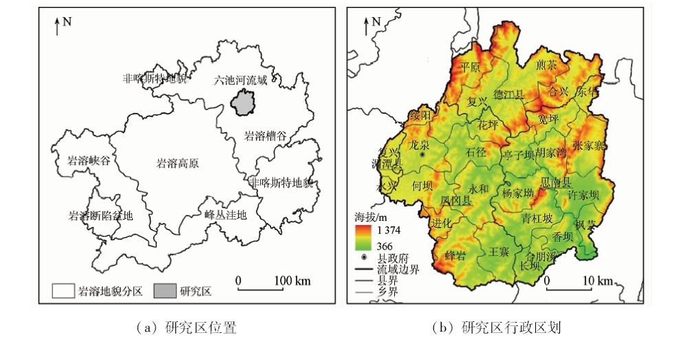
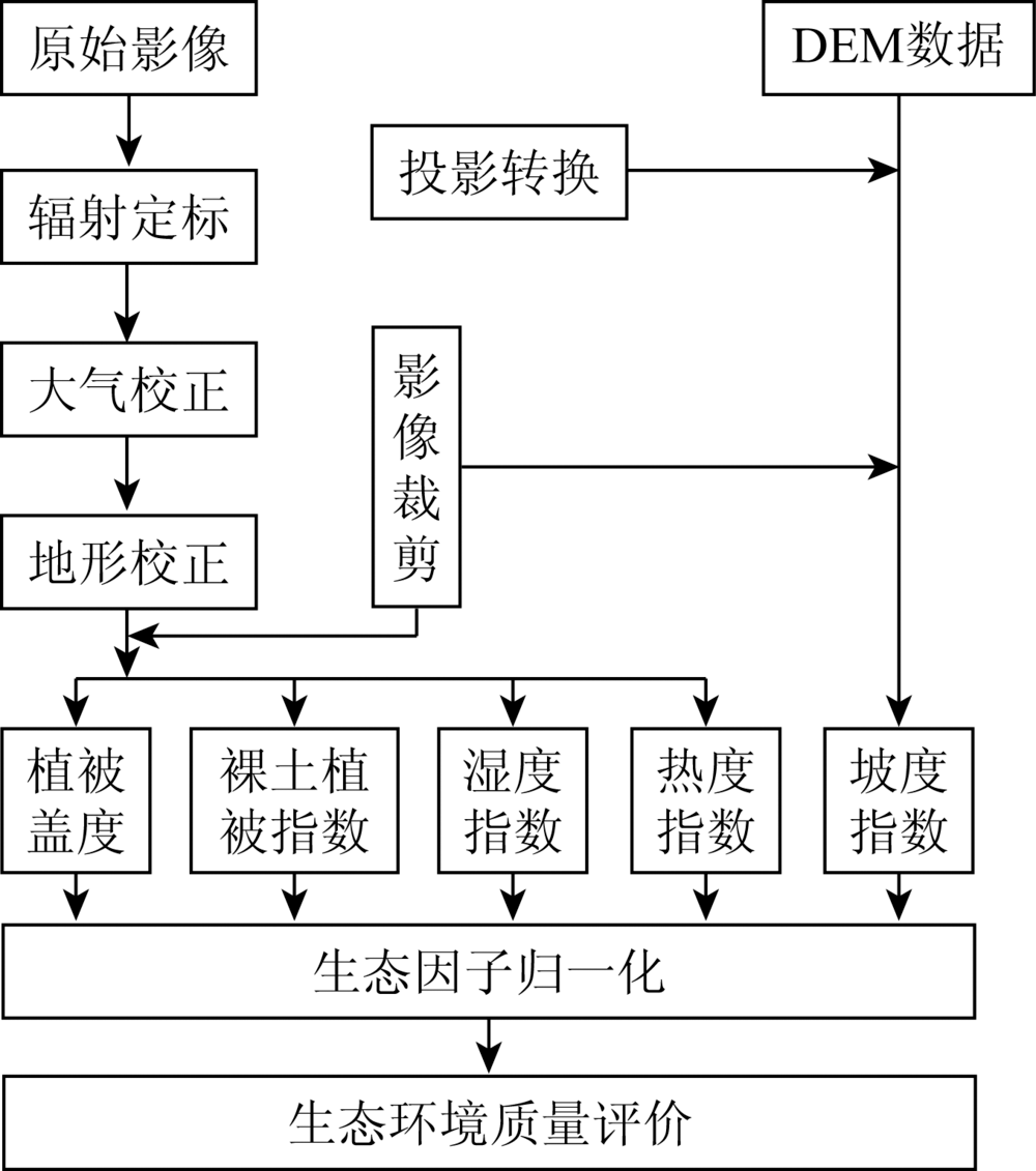
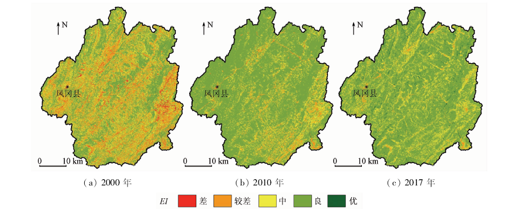
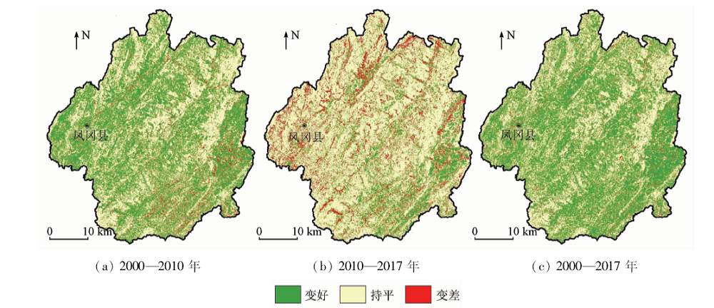
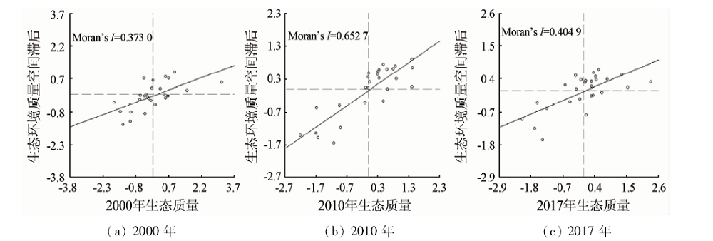
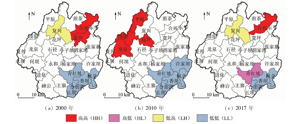
The ecological environment changes are related to social development. This paper analyzes the dynamic changes of the ecological environment quality of the Liuchi River Basin in Guizhou, in the hope of providing some reference that can promote the ecological civilization construction and environmental restoration of the watershed in the karst trough. The authors used remote sensing images which were from June to August, 2000, 2010 and 2017 Landsat satellites and GDEMDEM (30 m) data to extract vegetation cover, soil index, slope index, humidity and temperature index which served as the basis for constructing an ecological environment assessment model. In addition, spatial auto-correlation method was adopted to reveal the ecological environment that had different spatial and temporal characteristics in township scale. Some conclusions have been reached: ① From 2000 to 2017, the ecological environment quality showed a rapid restoration trend in the Liuchi River basin, but it varied differently in different counties. ② The quality of ecological environment showed significant differences in different towns. Meanwhile, the ecological improvement was slower in the county town and downstream towns, and was improved obviously in some towns of the central and southern area. ③ The ecological environment quality of towns had significant positive spatial agglomeration characteristics, and were dominated by high-high and low-low concentration in most years. In the trend analysis of towns’ ecological environment quality, the southeast basin was always the low-value zone, and the high-value zone is mainly distributed in the northern townships.
Wang G X, Qian J, Cheng G D. The method of regions eco-environmental assessment and its usage in the case of Heihe River basin[J]. Journal of Lanzhou University, 2001,37(2):131-140.
Li R Z. Eco-environmental assessment of basins based on grey associative theory[J]. Journal of Hefei University of Technology(Natural Science), 2002,25(3):464-467.
Wan X N, Liu J D, Cai J S. Quality estimating system about bio-environmental geology at Minjiang River upstream[J]. Advance in Earth Sciences, 2004,19(s1):477-481.
Yao W F, Zhang S C, Lyu X B, et al. Evaluation of ecological environment quality in Haihe River basin[C]//Anthology of 2004 Beijing Urban Water Conservancy Construction and Development International Symposium Proceedings.Beijing:[s.n.], 2004: 92-106.
Jin J L, Cheng J L, Wei Y M. Information entropy based fuzzy pattern recognition model for basin eco-environmental quality evaluation[J]. Journal of Sichuan University(Engineering Science Edition), 2006,38(1):5-9.
Dong S Y, Yang X, Wang X L, et al. Assessment of the eco-environmental quality in the Yongding River basin[J]. China Population,Resources and Environment, 2013,23(s2):348-351.
Wang S M, Huang C. Ecological environment quality monitoring and evaluation based on remote sensing and GIS techniques:A case of Wuding River basin[J]. Arid Land Geography, 2018,41(1):134-141.
Wei W, Shi P J, Zhou J J, et al. Comprehensive assessment of eco-environmental quality based on GIS and combination weighting method in Shiyang River basin[J]. Journal of Arid Land Resources and Environment, 2015,29(1):175-180.
Zhou X X, Luo H. Ecological environment quality assessment of Beipanjiang basin based on GIS and remote sense[J]. Environmental Science and Management, 2018,43(7):178-182.
Lu Y, Li X D, Yang Z Y. Evaluation on eco-environmental quality change of Wujiang River basin in Guizhou Province from 1990 to 2015[J]. Bulletin of Soil and Water Conservation, 2018,38(2):140-147.
An F, Li X D, Cheng D Y. Ecological vulnerability assessment and spatial variation characteristics of Wujiang River basin in Guizhou Province[J]. Bulletin of Soil and Water Conservation, 2019,39(4):261-269.
Huang F, Wei L, Li L, et al. Cumulative effects of water temperature by cascade hydropower stations built on upper and middle reaches of the Wujiang River[J]. Resources and Environment in the Yangtze Basin, 2009,18(4):337-342.
Xie R D, Zhao C W. Spatio-temporal differentiation of ecological environment vulnerability in karst trough region based on grid scale[J]. Journal of Yangtze River Scientific Research Institute, 2018,35(4):48-53.
Xiong K N, Chi Y K. The problems in southern China karst ecosystem in southern of China and its countermeasures[J]. Ecological Economy, 2015,31(1):23-30.
doi: 10.1016/S0921-8009(99)00052-X
Department of Rural Social Economic Investigation, National Bureau of Statistics. China county statistical yearbook (township volume)—2018[M]. Beijing: China Statistics Press, 2018.
Zhang J, Zhou X, Jiang X, et al. Spatial and temporal variability characteristics of water use efficiency in different landform regions and vegetation types of Guizhou plateau,China[J]. Mountain Research, 2019,37(2):173-185.
[20]
Tong X W, Wang K L, Yue Y M, et al. Quantifying the effectiveness of ecological restoration projects on long-term vegetation dynamics in the karst regions of Southwest China[J]. International Journal of Applied Earth Observation & Geoinformation, 2017,54:105-113.
doi: 10.1016/j.jag.2016.09.013
Wu Z J, He G J, Huang S L, et al. Terrain effects assessment on remotely sensed fractional vegetation cover in hilly area of southern China[J]. Journal of Remote Sensing, 2017,21(1):159-167.
[22]
田庆久, 闵祥军. 植被指数研究进展[J]. 地球科学进展, 1998,13(4):10-16.
Tian Q J, Min X J. Advances in study on vegetation indices[J]. Advances in Earth Science, 1998,13(4):10-16.
Yang C J, Liu J Y, Zhang Z X, et al. Analysis of features of soil erosion under different slope based on GIS[J]. Journal of Soil Water Conservation, 2002,16(6):46-49.
[24]
Crist E P. A TM tasseled cap equivalent transformation for reflectance factor data[J]. Remote Sensing of Environment, 1985,17(3):301-306.
doi: 10.1016/0034-4257(85)90102-6
[25]
Baig M H A, Zhang L F, Shuai T, et al. Derivation of a tasseled cap transformation based on Landsat8 at-satellite reflectance[J]. Remote Sensing Letters, 2014,5(5):423-431.
doi: 10.1080/2150704X.2014.915434
Jin D D, Gong Z N. Algorithms comparison of land surface temperature retrieval from Landsat series data:A case study in Qiqihar,China[J]. Remote Sensing Technology and Application, 2018,33(5):830-841.
Ren G P, Liu L M, Guan Q C, et al. Rurality evaluation and spatial autocorrelation type classification based on quality of life in metropolitan suburbs[J]. Transactions of the Chinese Society of Agricultural Engineering, 2019,35(7):264-275,317.
Wang L H, Zhang J M, Chen W H, et al. Spatiotemporal differentiation of ecological environment quality in the Manas River basin[J]. Arid Zone Research, 2019,36(4):1015-1023.
Wang Q, Li Y B, Liu Y X. Comparative study of land use change in karst hillside-trough dam area[J]. Resources and Environment in the Yangtze Basin, 2019,28(1):122-133.
[30]
刘凌. 思南七里塘水电站大坝施工导流设计[J].科技创新导报, 2011(25):115.
Liu L. Diversion design of the dam construction of Sinan Qilitang Hydropower Station[J].Science and Technology Innovation Herald 2011(25):115.
Zhang J. Discussion on the objectives and ways of constructing ecological civilized city in Guizhou[C]//Anthology of Proceedings of Guizhou Province Ecological Civilization Construction Symposium.Guiyang:[s.n.], 2008: 14-20.
[32]
林琳. 实施贵州工业强省战略的思考[J].宏观经济管理, 2012(8):74-75.
Lin L. Thoughts on implementing the strategy of Guizhou’s industrial province[J].Macroeconomic Management 2012(8):74-75.
Li Y B, Huang J, Xu Q, et al. Rethinking the concept and restoration of karst rocky desertification[J]. Journal of Guizhou Normal University(Natural Sciences), 2017,35(5):1-6,55.
[34]
贵州省林业局. 贵州省第三次石漠化监测成果公报[R]. 贵阳:贵州林业局, 2018.
Guizhou Forestry Bureau. Bulletin on the third rock desertification monitoring results in Guizhou Province[R]. Guiyang:Guizhou Forestry Bureau, 2018.
Cheng D Y, Li X D. Research on evaluation of forestland and grassland protection in southwest mountainous basin:A case study of the Chishui River basin in Guizhou Province[J]. Research of Soil and Water Conservation, 2019,26(4):328-335.
 2020, Vol. 32
  ), 李旭东(