ICESat-2 data-based monitoring of 2018—2021 variations in the water levels of lakes in the Qinghai-Tibet Plateau
MA Shanmu1,2(), GAN Fuping3(), WU Huaichun1,2, YAN Bokun3
1. State Key Laboratory of Biogeology and Environmental Geology, China University of Geosciences (Beijing), Beijing 100083, China 2. School of Ocean Sciences, China University of Geosciences(Beijing), Beijing 100083, China 3. China Aero Geophysical Survey and Remote Sensing Center for Natural Resources, Beijing 100083, China
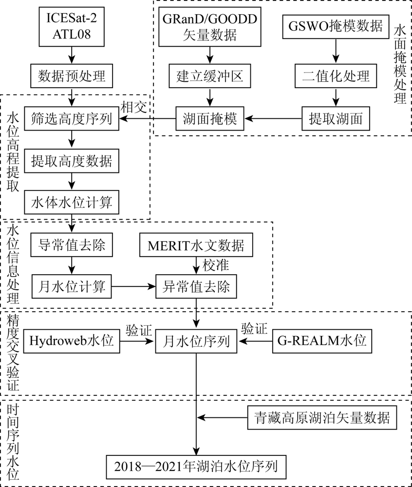
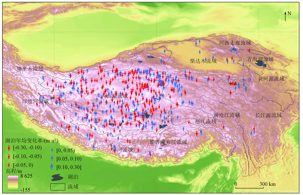
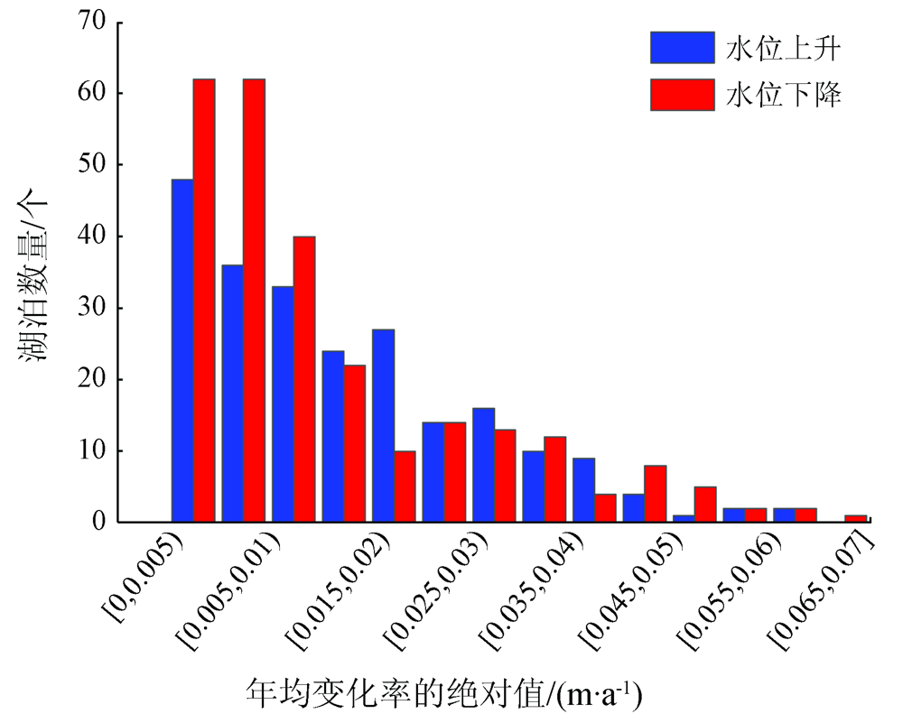
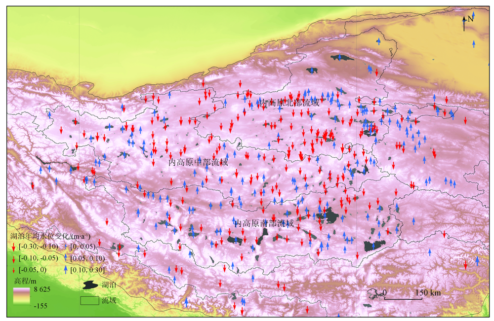
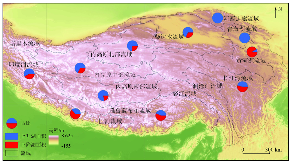
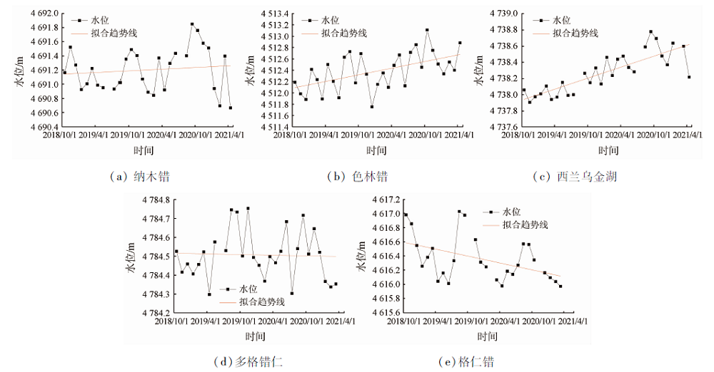
The variation in the water levels of lakes is an important indicator for the study of changes in climate and ecological environment and water resources rating. It was previously difficult for altimetry satellites to monitor small and medium-sized lakes, but the newly launched ICESat-2 satellite can improve the monitoring comprehensiveness and precision of lakes’ water levels. Based on the data coverage of ICESat-2 satellite land observation products, the high-precision dynamic monitoring of water levels was conducted for 473 lakes covering an area greater than 1 km2 in the Qinghai-Tibet Plateau from October 2018 to April 2021. The spatio-temporal variations of water levels of these lakes were analyzed from three aspects: the overall variations in the water levels of lakes in the Qinghai-Tibet Plateau, the basin-scaled and regional variations in the water levels of lakes, and the monthly or quarterly variation trends of water levels of typical lakes. The study results are as follows. In the past three years, the water levels of lakes in the Qinghai-Tibet Plateau continuously rose, with an average annual rate of variation of 0.013 m/a. The water levels of large, medium-sized, and small lakes rose significantly, rose gently, and dropped slightly, respectively. In terms of spatial distribution, the water levels of lakes in each basin generally showed an upward trend, and most of the lakes with declining water levels had relatively high elevations. During the monitoring period, the water level of Siling Co Lake rose by 1 m and that of Kering Tso Lake declined by 1 m. This study provides the latest monitoring data on the water levels of some lakes on the Qinghai-Tibet Plateau, which are conducive to the study of dynamic variation monitoring of lakes.
马山木, 甘甫平, 吴怀春, 闫柏琨. ICESat-2数据监测青藏高原湖泊2018—2021年水位变化[J]. 自然资源遥感, 2022, 34(3): 164-172.
MA Shanmu, GAN Fuping, WU Huaichun, YAN Bokun. ICESat-2 data-based monitoring of 2018—2021 variations in the water levels of lakes in the Qinghai-Tibet Plateau. Remote Sensing for Natural Resources, 2022, 34(3): 164-172.
Zhang Q, Liu C L, Xu C Y, et al. Observed trends of annual maximum water level and streamflow during past 130 years in the Yangtze River basin,China[J]. Journal of Hydrology, 2006, 324(1-4):255-265.
doi: 10.1016/j.jhydrol.2005.09.023
[2]
Wan W, Long D, Hong Y, et al. A lake data set for the Tibetan Plateau from the 1960s,2005,and 2014[J]. Scientific Data, 2016, 3:160039.
doi: 10.1038/sdata.2016.39
Gao L, Liao J J, Liu H L, et al. Applying status and development tendency of satellite Radar altimeter[J]. Remote Sensing Technolo-gy and Application, 2013, 28(6):978-983.
[4]
Hwang C, Cheng Y S, Han J, et al. Multi-decadal monitoring of lake level changes in the Qinghai-Tibet Plateau by the TOPEX/Poseidon-family altimeters:Climate implication[J]. Remote Sensing, 2016, 8(6):446.
doi: 10.3390/rs8060446
[5]
Gao L, Liao J, Shen G. Monitoring lake-level changes in the Qinghai-Tibetan Plateau using Radar altimeter data (2002—2012)[J]. Journal of Applied Remote Sensing, 2013, 7(1):073470.
doi: 10.1117/1.JRS.7.073470
[6]
Song C, Huang B, Ke L, et al. Seasonal and abrupt changes in the water level of closed lakes on the Tibetan Plateau and implications for climate impacts[J]. Journal of Hydrology, 2014(514):131-144.
[7]
Chen J, Liao J. Monitoring lake level changes in China using multi-altimeter data (2016—2019)[J]. Journal of Hydrology, 2020, 590:125544.
doi: 10.1016/j.jhydrol.2020.125544
Jiang W P, Chu Y H, Li J C, et al. Water level variation of Qinghai Lake from altimeteric data[J]. Geomatics and Information Science of Wuhan University, 2008(1):64-67.
Zhao Y, Liao J J, Shen G Z, et al. Monitoring the water level changes in Qinghai Lake with satellite altimetry data[J]. Journal of Remote Sensing, 2017, 21(4):633-644.
Wu H B, Chen Y D. Estimation of lake water storage change of Qinghai Lake based on the ICESat satellite altimetry data and Landsat satellite imageries[J]. Journal of Water Resources and Water Engineering, 2020, 31(5):7-15,22.
Liao J J, Xue H, Chen J M. Monitoring lake level changes on the Tibetan Plateau from 2000 to 2018 using satellite altimetry data[J]. Journal of Remote Sensing, 2020, 24(12):1534-1547.
[12]
Neuenschwander A, Pitts K. The ATL08 land and vegetation product for the ICESat-2 mission[J]. Remote Sensing of Environment, 2019(221):247-259.
[13]
Abdalati W, Zwally H J, Bindschadler R, et al. The ICESat-2 laser altimetry mission[J]. Proceedings of the IEEE, 2010, 98(5):735-751.
doi: 10.1109/JPROC.2009.2034765
[14]
Markus T, Neumann T, Martino A, et al. The ice,cloud,and land elevation satellite-2 (ICESat-2):Science requirements,concept,and implementation[J]. Remote Sensing of Environment, 2017, 190:260-273.
doi: 10.1016/j.rse.2016.12.029
[15]
Li G Y. Earth observing satellite laser altimeter data processing method and engineer practice[J]. Acta Geodaetica et Cartographica Sinica, 2018, 47(12):1691.
[16]
Pekel J F, Cottam A, Gorelick N, et al. High-resolution mapping of global surface water and its long-term changes[J]. Nature, 2016, 540(7633):418-422.
doi: 10.1038/nature20584
[17]
Grill G, Lehner B, Thieme M, et al. Mapping the world’s free-flowing rivers[J]. Nature, 2019, 569(7755):215-221.
doi: 10.1038/s41586-019-1111-9
[18]
Birkett C M, Reynolds C A, Deeb E J, et al. G-REALM:A lake/reservoir monitoring tool for water resources and regional security assessment[C]// American Geophysical Union Fall Meeting, 2018.
[19]
Cretaux J F, Jelinski W, Calmant S, et al. SOLS:A lake database to monitor in the near real time water level and storage variations from remote sensing data[J]. Advances in Space Research, 2011, 47(9):1497-1507.
doi: 10.1016/j.asr.2011.01.004
[20]
Yamazaki D, Ikeshima D, Sosa J, et al. MERIT Hydro:A high-resolution global hydrography map based on latest topography dataset[J]. Water Resources Research, 2019, 55(6):5053-5073.
doi: 10.1029/2019WR024873
[21]
Cooley S W, Ryan J C, Smith L C. Human alteration of global surface water storage variability[J]. Nature, 2021, 591(7848):78-81.
doi: 10.1038/s41586-021-03262-3
[22]
Luo S, Song C, Zhan P, et al. Refined estimation of lake water level and storage changes on the Tibetan Plateau from ICESat/ICESat-2[J]. Catena, 2021, 200:105177.
doi: 10.1016/j.catena.2021.105177
[23]
Zhang G Q, Yao T D, Shum C K, et al. Lake volume and groundwater storage variations in Tibetan Plateau’s endorheic basin[J]. Geo-physical Research Letters, 2017, 44(11):5550-5560.
doi: 10.1002/2017GL073773
[24]
Yang K, Wu H, Qin J, et al. Recent climate changes over the Tibetan Plateau and their impacts on energy and water cycle:A review[J]. Global and Planetary Change, 2014, 112:79-91.
doi: 10.1016/j.gloplacha.2013.12.001
[25]
Chen B X, Zhang X Z, Tao J, et al. The impact of climate change and anthropogenic activities on alpine grassland over the Qinghai-Tibet Plateau[J]. Agricultural and Forest Meteorology, 2014, 189:11-18.
 2022, Vol. 34
  ), 甘甫平3(