Please wait a minute...
 
自然资源遥感  2022, Vol. 34 Issue (4): 87-96    DOI: 10.6046/zrzyyg.2022101
  海岸带空间资源及生态健康遥感监测专栏 本期目录 | 过刊浏览 | 高级检索 |
胶东半岛北部海岸线时空变迁及驱动分析
赵连杰1(), 吴孟泉1(), 郑龙啸1, 栾绍鹏2, 赵贤峰3, 薛明月1, 刘佳燕1, 刘晨曦4
1.鲁东大学资源与环境工程学院,烟台 264039
2.烟台市地理信息中心,烟台 264000
3.烟台市土地储备和利用中心,烟台 264000
4.长江大学地球科学学院,武汉 430100
Temporal-spatial changes and driving analysis of the northern shorelines of Jiaodong Peninsula
ZHAO Lianjie1(), WU Mengquan1(), ZHENG Longxiao1, LUAN Shaopeng2, ZHAO Xianfeng3, XUE Mingyue1, LIU Jiayan1, LIU Chenxi4
1. School of Resources and Environmental Engineering, Ludong University, Yantai 264039, China
2. Yantai Geographic Information Center, Yantai 264000, China
3. Yantai Land Reserve and Use Centre, Yantai 264000, China
4. School of Earth Sciences, Yangtze University, Wuhan 430100, China
全文: PDF(3575 KB)   HTML  
输出: BibTeX | EndNote (RIS)      
摘要 

海岸线动态监测对于海岸带科学管理和海洋资源合理利用具有重要意义。选用1990年、2000年、2010年和2020年共4期Landsat遥感影像数据,对比并采用了面向对象法提取了胶东半岛北部1990—2020年的海岸线和近岸2 km缓冲区内的海岸带变化,结合海岸线变迁强度的计算方法,利用数字岸线分析系统(digital shoreline analysis system,DSAS)分析了海岸线的变化速率和时空分布特征,通过构建人类活动强度指数 (human activity intensity index,HAII) 模型对海岸线的变化进行了驱动分析。结果表明: ①研究区海岸线整体呈增长趋势,并向海一侧缓慢推进,海岸线长度总体增加了183.13 km,人工岸线增幅最大,砂质自然岸线减幅最大; ②海岸线变化速率时空分布不均衡,最大增速出现在胶莱河—界河区段,为94.59 m/a,最大侵蚀速率出现在界河—大沽夹河区段,为-49.01 m/a; ③近海人类活动变化是研究区海岸线时空变迁的主要原因,人类活动主要以围填海、港口建设等形式影响着海岸线的长度和类型变化。

服务
把本文推荐给朋友
加入引用管理器
E-mail Alert
RSS
作者相关文章
赵连杰
吴孟泉
郑龙啸
栾绍鹏
赵贤峰
薛明月
刘佳燕
刘晨曦
关键词 面向对象支持向量机数字岸线分析系统时空变迁人类活动强度指数    
Abstract

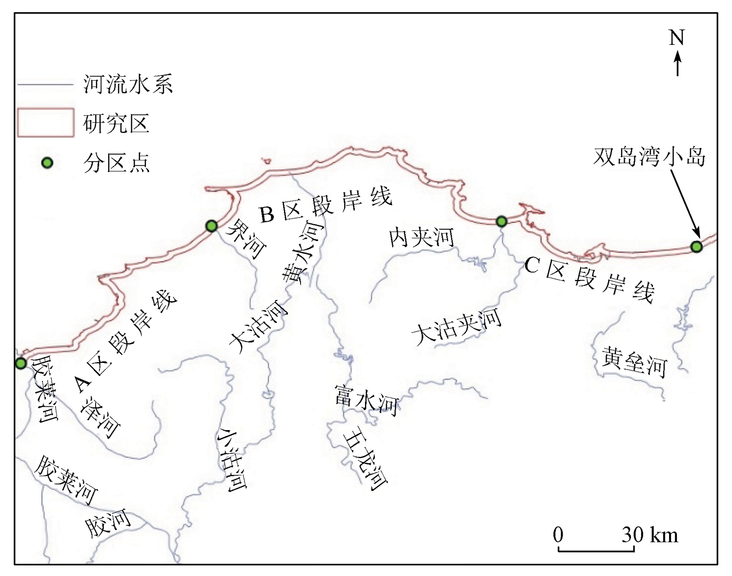
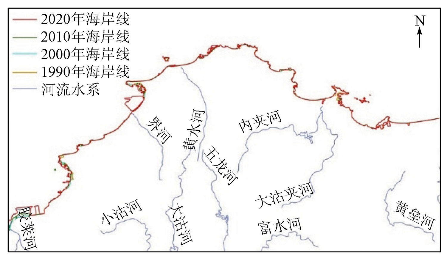
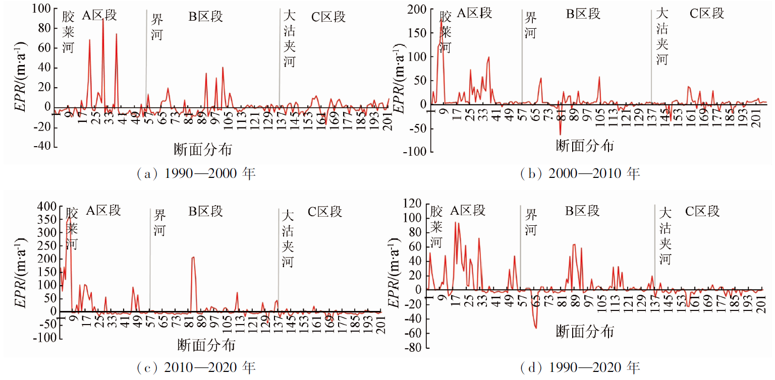
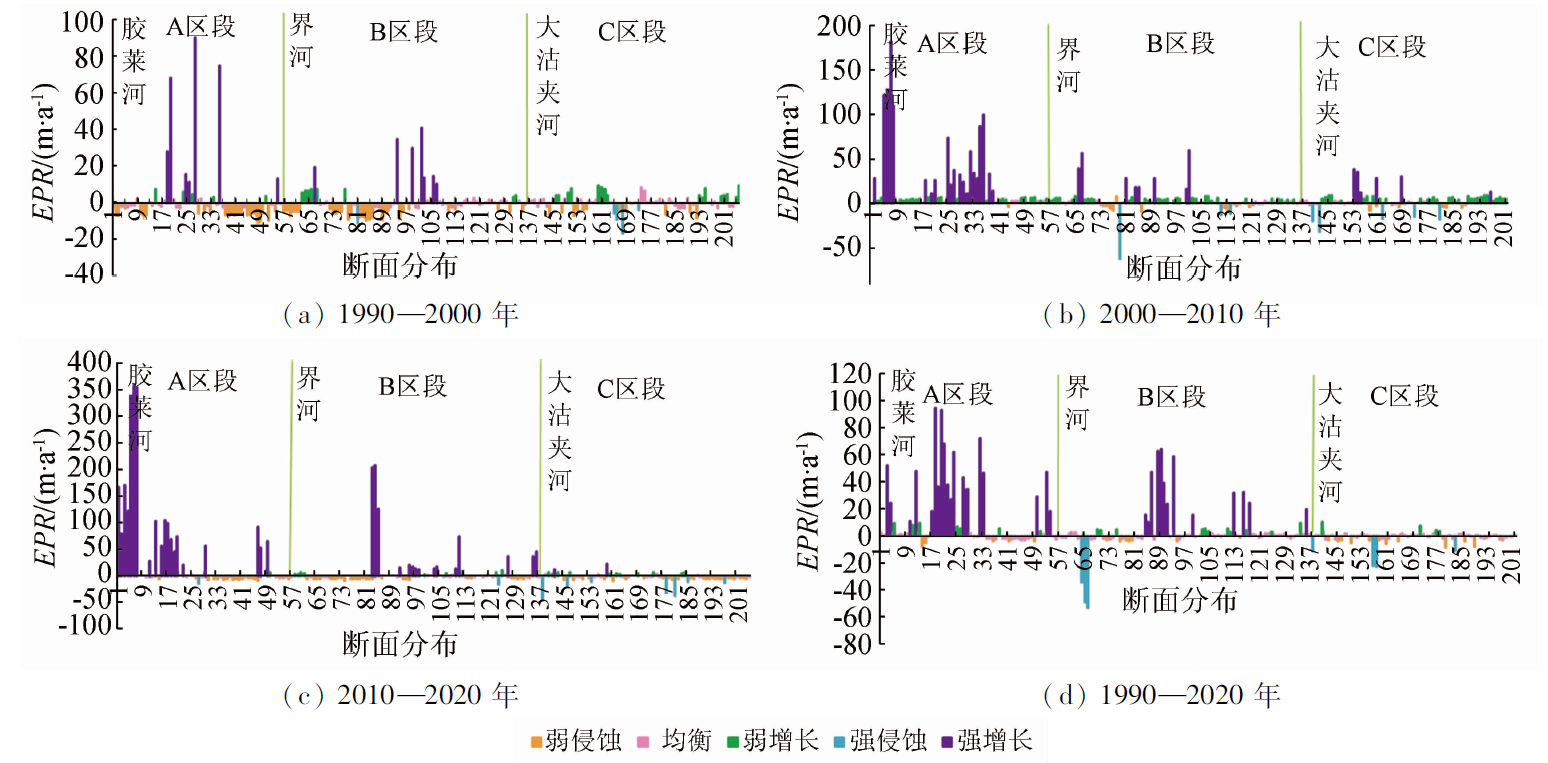
Dynamic shoreline monitoring is greatly significant for the scientific management of coastal zones and the rational utilization of marine resources. Based on the Landsat remote sensing images of four periods i.e., 1990, 2000, 2010, and 2020, this study extracted the changes in the shorelines and the coastal zones within the 2 km of the buffer zone in the north of Jiaodong Peninsula from 1990 to 2020 by making comparison and using an object-oriented method. By combining the calculation method for shoreline change intensity, this study analyzed the changing rate and temporal-spatial distribution characteristics of the shorelines using the digital shoreline analysis system (DSAS). Then, this study conducted a driving analysis of changes in the shoreline by constructing a human activity intensity index (HAII) model. The results are as follows. The shorelines of the study area generally showed an upward trend and advanced slowly to the seaside. The overall length of the shorelines increased by 183.13 km. The highest increased and decreased amplitude occurred in artificial shorelines and sandy natural shorelines, respectively. The shoreline changing rates showed uneven temporal-spatial distribution. The maximum growth rate of 94.59 m/a occurred in the Jiaolai River - Jiehe River section, while the maximum erosion rate of -49.01 m/a occurred in the Jiehe River - Dagujia River section. The changes in offshore human activities were the main contributor to the temporal-spatial changes of coastlines in the study area. The lengths and types of shorelines were mainly affected by human activities through sea reclamation and port construction.

Key wordsobject oriented    SVM    DSAS    temporal and spatial changes    human activity intensity index
收稿日期: 2022-03-21      出版日期: 2022-12-27
ZTFLH:  P237  
  P74  
  P737.1  
基金资助:国家自然科学基金项目“黄海浒苔衰亡过程与浮游微藻生态响应的遥感监测研究”(42071385);山东省自然科学基金项目“基于遥感的黄海浒苔与浮游植物竞争关系对营养盐变化的响应研究”(ZR2019MD041);烟台市科技创新发展计划重点研发类项目‘星-机-地’联合监测海阳浒苔的生态效应关键技术与示范(2022MSGY062);山东省海上航天装备技术创新中心(鲁东大学)开放课题基金项目“基于‘空天地’一体的浒苔衰亡对黄海海洋生态遥感监测研究”(HHCXZX-2021-12)
通讯作者: 吴孟泉(1975-),男,教授,硕士生导师,博士,研究方向为海洋环境遥感、空间分析及3S应用研究。Email: ld_wmq@ldu.edu.cn
作者简介: 赵连杰(1995-),女,硕士研究生,研究方向为海洋环境遥感、土地利用变化、空间分析与3S应用研究。Email: gislucas@163.com
引用本文:   
赵连杰, 吴孟泉, 郑龙啸, 栾绍鹏, 赵贤峰, 薛明月, 刘佳燕, 刘晨曦. 胶东半岛北部海岸线时空变迁及驱动分析[J]. 自然资源遥感, 2022, 34(4): 87-96.
ZHAO Lianjie, WU Mengquan, ZHENG Longxiao, LUAN Shaopeng, ZHAO Xianfeng, XUE Mingyue, LIU Jiayan, LIU Chenxi. Temporal-spatial changes and driving analysis of the northern shorelines of Jiaodong Peninsula. Remote Sensing for Natural Resources, 2022, 34(4): 87-96.
链接本文:  
https://www.gtzyyg.com/CN/10.6046/zrzyyg.2022101      或      https://www.gtzyyg.com/CN/Y2022/V34/I4/87
Fig.1  研究区范围示意图
序号 卫星 传感器类型 轨道号/
行号
日期 空间分
辨率/m
1 Landsat5 TM 120/34 1990年 30
2 Landsat5 TM 120/34 2000年 30
3 Landsat5/7 TM/ETM+ 120/34 2010年 30
4 Landsat8 OLI 120/34 2020年 30
Tab.1  遥感卫星影像数据参数信息
分类对象 分类类别 类别特征 影像解译标志
海岸线 砂质岸线 主要在海风、海浪、潮汐、洋流的共同作用下堆积而成的海岸线 海岸线较为平直,退潮后露出的沙滩在影像上的亮度较低,没有被海水淹没过的沙滩亮度较高,主要表现为高低亮度沙砾间的分界线
淤泥质岸线 位于淤泥质或粉砂质泥滩的海岸线 滩面坡度平缓,向陆一侧通常有植物呈条带状生长
基岩岸线 通常由海岬和海湾组成,底部会长期受到海浪、潮汐的影响而不断侵蚀 光谱反射率偏低,影像上较为平直,干湿线表现较为明显
人工岸线 主要由混凝土、石头修筑而成,包括港口码头、近海养殖、构筑物、堤坝等建设用地的海岸线 在影像上具有较高的反射率,与具有较低反射率的海水形成鲜明的对比,地物形状规则,多为线状或块状
海岸带 农田 以种植作物为主的土地 具有规则的几何形状,整体分布较为集中
居住地 用于居住和商业区等的土地 分布较为密集,多呈块状聚集分布
道路 用来供各种车辆和行人通行的基础设施用地 整体呈网状分布,交错分布,多邻近建筑区
林草 主要包括林地、草地等植被类型覆盖的土地 颜色较深,呈不规则的块状或条带状分布
水域 指江河、湖泊、运河、渠道、水库、水塘及其管理范围和水工设施 反射率较低,在影像上颜色较深,表现明显
裸地 主要包括空闲地、荒地和未利用的裸地 基本无植物覆盖,反射率低于沙漠,颜色呈灰色
建设用地 主要包括临海港口建设、盐田建设、人工堆掘地等临海建设用地 反射率较高,建筑物色调呈白色,地物构成多样化,码头处凸出的构筑物多呈白色,细长突出
Tab.2  海岸线、海岸带分类类别构建
土地利用类型 农田 居住地 道路 林草 水域 裸地 建设用地
干扰强度系数 0.52 0.92 0.86 0.10 0.13 0.06 0.91
Tab.3  各土地利用类型因子的干扰强度系数
分类方法 海岸线类型
砂质岸
线
淤泥质
岸线
基岩岸
线
人工岸
线
基于阈值分割 6.84 28.56 18.47 14.56
基于面向对象 9.65 24.31 15.35 12.39
Tab.4  不同方法提取的水边线与基线的误差分析结果
Fig.2  1990—2020年胶东半岛北部海岸线的空间分布
年份 自然岸线 人工岸线 研究区
总岸线
砂质岸线 淤泥质岸线 基岩岸线
1990年 213.44 6.36 48.12 139.24 407.16
2000年 173.18 5.91 37.31 217.14 433.54
2010年 150.15 5.48 39.35 282.57 477.55
2020年 170.08 5.08 40.61 374.52 590.29
Tab.5  1990—2020年胶东半岛北部各类型海岸线长度统计
时间段 海岸线区段 变化长度
/km
断面分布 断面个数 平均变化速率 最大增长速率 最大侵蚀速率 平均增长或侵蚀
EPR/(m·a-1) EPR/(m·a-1) EPR/(m·a-1) NSM/m
1990—2000年 A区段 -0.90 1—57 57 -1.58 90.00 -10.69 -15.78
B区段 20.10 57—137 81 0.53 40.76 -21.04 5.34
C区段 7.18 137—121 65 0.24 5.50 -9.32 2.35
2000—2010年 A区段 14.21 1—57 57 10.91 181.07 -6.05 109.11
B区段 18.88 57—137 81 4.05 58.61 -62.77 58.73
C区段 10.92 137—121 65 4.44 8.33 -18.03 44.32
2010—2020年 A区段 42.92 1—57 57 19.03 360.62 -4.12 171.24
B区段 82.39 57—137 81 13.57 204.49 -45.16 54.85
C区段 -12.57 137—121 65 -6.41 4.79 -36.93 -17.51
1990—2020年 A区段 56.23 1—57 57 6.12 94.59 -9.13 177.56
B区段 121.37 57—137 81 4.76 62.67 -49.01 138.20
C区段 5.53 137—121 65 -10.75 4.22 -21.96 -14.59
Tab.6  1990—2020年胶东半岛北部海岸线的空间变迁趋势
Fig.3  1990—2020年胶东半岛北部海岸线EPR的空间分布
Fig.4  1990—2020年胶东半岛北部海岸线不同断面的侵蚀类型
方法 错分精度/% 漏分精度/% Kappa系数 总体精度/%
SVM 3.24 34.68 0.824 87.96
KNN 7.51 36.12 0.795 84.91
Tab.7  不同分类提取方法的精度比较
Fig.5  1990—2020年胶东半岛北部海岸带HAII空间分布及各土地利用类型变化
[1] 马小峰, 赵冬至, 张丰收, 等. 海岸线卫星遥感提取方法研究进展[J]. 遥感技术与应用, 2007, 22(4):575-580.
Ma X F, Zhao D Z, Zhang F S, et al. Means of withdrawing coastline by remote sensing[J]. Remote Sensing Technology and Application, 2007, 22(4):575-580.
[2] 吴一全, 刘忠林. 遥感影像的海岸线自动提取方法研究进展[J]. 遥感学报, 2019, 23(4):582-602.
Wu Y Q, Liu Z L. Research progress on methods of automatic coastline extraction based on remote sensing images[J]. Journal of Remote Sensing, 2019, 23(4):582-602.
[3] 李加林, 田鹏, 邵姝遥, 等. 中国东海区大陆岸线变迁及其开发利用强度分析[J]. 自然资源学报, 2019, 34(9):1886-1901.
Li J L, Tian P, Shao S Y, et al. The change of continental coastline and its development and utilization intensity in the East China Sea[J]. Journal of Natural Resources, 2019, 34(9):1886-1901.
doi: 10.31497/zrzyxb.20190907
[4] Zhou M, Wu M Q, Zhang G Z, et al. Analysis of voastal zone data of northern Yantai collected by remote sensing from 1990 to 2018[J]. Applied Sciences, 2019, 9(20):4466.
doi: 10.3390/app9204466
[5] 孙晓林, 吴孟泉, 田佳慧, 等. 近30年威海市海岸线时空变化及其驱动力[J]. 应用海洋学学报, 2019, 38(2):206-213.
Sun X L, Wu M Q, Tian J H, et al. Driving forces and spatio-temporal variation of Weihai coastline in recent 30 years[J]. Journal of Applied Oceanography, 2019, 38(2):206-213.
[6] Dai C, Howat I M, Larour E, et al. Coastline extraction from repeat high resolution satellite imagery[J]. Remote Sensing of Environment, 2019, 229:260-270.
doi: 10.1016/j.rse.2019.04.010
[7] 姚晓静, 高义, 杜云艳, 等. 基于遥感技术的近30 a海南岛海岸线时空变化[J]. 自然资源学报, 2013, 28(1):114-125.
Yao X J, Gao Y, Du Y Y, et al. Spatial and temporal changes of Hainan coastline in the past 30 years based on RS[J]. Journal of Natural Resources, 2013, 28(1):114-125.
[8] 刘百桥, 孟伟庆, 赵建华, 等. 中国大陆1990—2013年海岸线资源开发利用特征变化[J]. 自然资源学报, 2015, 30(12):2033-2044.
Liu B Q, Meng W Q, Zhao J H, et al. Variation of coastline resources utilization in China from 1990 to 2013[J]. Journal of Natural Resources, 2015, 30(12):2033-2044.
[9] 王志成, 高志强, 尚伟涛, 等. 1987—2017年莱州湾沿岸土地利用变化及其对海岸线变化的影响[J]. 水土保持通报, 2021, 41(1):309-316,336.
Wang Z C, Gao Z Q, Shang W T, et al. Land use change and it’s influence on coastline change along Laizhou Bay during 1987—2017[J]. Bulletin of Soil and Water Conservation, 2021, 41(1):309-316,336.
[10] 柏叶辉, 李洪忠, 李向新, 等. 1990年以来4个时期深圳市海岸线与海岸带景观格局及其对人类活动强度的响应[J]. 湿地科学, 2019, 17(3):335-343.
Bo Y H, Li H Z, Li X X, et al. Landscape patterns of coastline and coastal zone in Shenzhen City and their responses to intensity of human activities for 4 periods since 1990[J]. Wetland Science, 2019, 17(3):335-343.
[11] 苗苗, 谢小平. 基于GIS和RS的山东日照海岸带1988—2018年间演化分析[J]. 国土资源遥感, 2021, 33(2):237-247.doi:10.6046/gtzyyg.2020229.
doi: 10.6046/gtzyyg.2020229
Miao M, Xie X P. Spatial- temporal evolution analysis of Rizhao coastal zone during 1988—2018 based on GIS and RS[J]. Remote Sensing for Land and Resources, 2021, 33(2):237-247.doi:10.6046/gtzyyg.2020229.
doi: 10.6046/gtzyyg.2020229
[12] Mullick M R A, Islam K M A, Tanim A H. Shoreline change assessment using geospatial tools:A study on the Ganges deltaic coast of Bangladesh[J]. Earth Science Informatics, 2020, 13(2):99-316.
[13] Baral R, Pradhan S, Samal R N, et al. Shoreline change analysis at Chilika Lagoon Coast,India using digital shoreline analysis system[J]. Journal of the Indian Society of Remote Sensing, 2018, 46(10):1637-1644.
doi: 10.1007/s12524-018-0818-7
[14] 杨磊, 李加林, 袁麒翔, 等. 中国南方大陆海岸线时空变迁[J]. 海洋学研究, 2014, 32(3):42-49.
doi: 10.3969/j.issn.1001-909X.2014.03.006
Yang L, Li J L, Yuan Q X, et al. Spatial-temporal changes of continental coastline in southern China[J]. Journal of Marine Sciences, 2014, 32(3):42-49.
doi: 10.3969/j.issn.1001-909X.2014.03.006
[15] 张旭凯, 张霞, 杨邦会, 等. 结合海岸类型和潮位校正的海岸线遥感提取[J]. 国土资源遥感, 2013, 25(4):91-97.doi:10.6046/gtzyyg.2013.04.15.
doi: 10.6046/gtzyyg.2013.04.15
Zhang X K, Zhang X, Yang B H, et al. Coastline extraction using remote sensing based on coastal type and tidal correction[J]. Remote Sensing for Land and Resources, 2013, 25(4):91-97.doi:10.6046/gtzyyg.2013.04.15.
doi: 10.6046/gtzyyg.2013.04.15
[16] 段秋亚, 孟令奎, 樊志伟, 等. GF-1卫星影像水体信息提取方法的适用性研究[J]. 国土资源遥感, 2015, 27(4):79-84.doi:10.6046/gtzyyg.2015.04.13.
doi: 10.6046/gtzyyg.2015.04.13
Duan Q Y, Meng L K, Fan Z W, et al. Applicability of the water information extraction method based on GF-1 image[J]. Remote Sensing for Land and Resources, 2015, 27(4):79 -84.doi:10.6046/gtzyyg.2015.04.13.
doi: 10.6046/gtzyyg.2015.04.13
[17] 王彩艳, 王瑷玲, 王介勇, 等. 基于面向对象的海岸带土地利用信息提取研究[J]. 自然资源学报, 2014, 29(9):1589-1597.
Wang C Y, Wang A L, Wang J Y, et al. Coastal zone land use information extraction based on object-oriented classification method[J]. Journal of Natural Resources, 2014, 29(9):1589-1597.
[18] 原晓慧, 王萍, 张英, 等. 基于边缘检测的海岸线自动提取研究[J]. 北京测绘, 2019, 33(2):148-152.
Yuan X H, Wang P, Zhang Y, et al. Research on edge detection and object-oriented for automatic extraction of coastline[J]. Beijing Surveying and Mapping, 2019, 33(2):148-152.
[19] 张翔, 王霄鹏, 黄安齐, 等. 基于遥感影像提取山东半岛复杂海岸线及海岸线多年变迁研究[J]. 海洋湖沼通报, 2021, 43(2):171-181.
Zhang X, Wang X P, Huang A Q, et al. Extraction of complex coastline feature and it’s multi-year changes in Shandong Peninsula based on remote sensing image[J]. Transactions of Oceanology and Limnology, 2021, 43(2):171-181.
[20] 吴琳娜, 杨胜天, 刘晓燕, 等. 1976年以来北洛河流域土地利用变化对人类活动程度的响应[J]. 地理学报, 2014, 69(1):54-63.
Wu L N, Yang S T, Liu X Y, et al. Response analysis of land use change to the degree of human activities in Beiluo River basin since 1976[J]. Journal of Geographical Sciences, 2014, 69(1):54-63.
[21] 陈浮, 陈刚, 包浩生, 等. 城市边缘区土地利用变化及人文驱动力机制研究[J]. 自然资源学报, 2001, 16(3):204-210.
Chen F, Chen G, Bao H S, et al. Analysis on land use change and human driving force in urban fringe[J]. Journal of Natural Resources, 2001, 16(3):204-210.
[22] 梁发超, 刘黎明. 景观格局的人类干扰度定量分析与生态功能区优化初探:以福建省闽清县为例[J]. 资源科学, 2011, 33(6):1138-1144.
Liang F C, Liu L M. Quantitative analysis of human disturbance intensity of landscape ptterns and preliminary optimization of ecological function regions:A case of Minqing County in Fujian Province[J]. Resources Science, 2011, 33(6):1138-1144.
[23] 徐勇, 孙晓一, 汤青. 陆地表层人类活动强度:概念、方法及应用[J]. 地理学报, 2015, 70(7):1068-1079.
doi: 10.11821/dlxb201507004
Xu Y, Sun X Y, Tang Q. Human activity intensity of land surface:Concept,method and application in China[J]. Journal of Geographical Sciences, 2015, 70(7):1068-1079.
[24] 李振鹏, 刘黎明, 谢花林. 乡村景观分类的方法探析:以北京市海淀区白家疃村为例[J]. 资源科学, 2005, 27(2):167-173.
Li Z P, Liu L M, Xie H L. Methodology of rural landscape classification:A case study in Baijiatuan Village Haidian District,Beijing[J]. Resources Science, 2005, 27(2):167-173.
[25] 贾艳艳, 唐晓岚, 张卓然. 长江中下游流域自然保护地空间分布及其与人类活动强度关系研究[J]. 世界地理研究, 2020, 29(4):845-855.
doi: 10.3969/j.issn.1004-9479.2020.04.2019131
Jia Y Y, Tang X L, Zhang Z R. Distribution of nature protected areas and its relationship with human activity intensity in the middle and lower reaches of the Yangtze River basin[J]. World Regional Studies, 2020, 29(4):845-855.
doi: 10.3969/j.issn.1004-9479.2020.04.2019131
[26] 孙贵芹, 徐艳东, 林蕾, 等. 基于遥感和GIS的烟台芝罘湾海岸线变迁研究[J]. 海洋科学进展, 2020, 38(1):140-152.
Sun G Q, Xu Y D, Lin L, et al. Coastline changes in the Zhifu Bay of Yantai City based on remote sensing and GIS[J]. Advances in Marine Science, 2020, 38(1):140-152.
[1] 陈昊宇, 项磊, 高贺, 牟金燚, 索晓晶, 滑博伟. 基于分数阶微分的土壤全氮高光谱反演[J]. 自然资源遥感, 2023, 35(3): 170-178.
[2] 李志新, 王梦飞, 贾伟洁, 纪松, 王宇飞. 一种结合阴影信息的建筑物层数识别方法[J]. 自然资源遥感, 2023, 35(3): 97-106.
[3] 梁茜亚, 王卷乐, 李朋飞, DAVAADORJ Davaasuren. 基于GF-1影像的蒙古高原干旱半干旱地区自然道路提取——以蒙古国古尔班特斯苏木为例[J]. 自然资源遥感, 2023, 35(2): 122-131.
[4] 张仙, 李伟, 陈理, 杨昭颖, 窦宝成, 李瑜, 陈昊旻. 露天开采矿区要素遥感提取研究进展及展望[J]. 自然资源遥感, 2023, 35(2): 25-33.
[5] 石敏, 李慧颖, 贾明明. 基于GEE云平台与Landsat数据的山口自然保护区红树林时空变化分析[J]. 自然资源遥感, 2023, 35(2): 61-69.
[6] 李天驰, 王道儒, 赵亮, 凡仁福. 基于Landsat8遥感数据的西沙群岛永乐环礁底质分类与变化分析[J]. 自然资源遥感, 2023, 35(2): 70-79.
[7] 李晨辉, 郝利娜, 许强, 王一, 严丽华. 面向对象的高分辨率遥感影像地震滑坡分层识别[J]. 自然资源遥感, 2023, 35(1): 74-80.
[8] 张雨, 明冬萍, 赵文祎, 徐录, 赵治, 刘冉. 基于高分光学卫星影像的泸定地震型滑坡提取与分析[J]. 自然资源遥感, 2023, 35(1): 161-170.
[9] 邓静雯, 田义超, 张强, 陶进, 张亚丽, 黄升光. 机载LiDAR在红树林林分平均高估算中的应用[J]. 自然资源遥感, 2022, 34(3): 129-137.
[10] 王春霞, 张俊, 李屹旭, Phoumilay. 复杂环境下GF-2影像水体指数的构建及验证[J]. 自然资源遥感, 2022, 34(3): 50-58.
[11] 朱琦, 郭华东, 张露, 梁栋, 刘栩婷, 万祥星. 基于多时相Landsat8影像的海南岛热带天然林类型遥感分类[J]. 自然资源遥感, 2022, 34(2): 215-223.
[12] 孙肖, 彭军还, 赵锋, 王晓阳, 吕洁, 张登峰. 基于空间统计学的高光谱遥感影像主成分选择方法[J]. 自然资源遥感, 2022, 34(2): 37-46.
[13] 赵晓伟, 黄杨, 汪永强, 储鼎. 基于无人机多光谱数据的玉米苗株估算[J]. 自然资源遥感, 2022, 34(1): 106-114.
[14] 范莹琳, 娄德波, 张长青, 魏英娟, 贾福东. 基于面向对象的铁尾矿信息提取技术研究——以迁西地区北京二号遥感影像为例[J]. 自然资源遥感, 2021, 33(4): 153-161.
[15] 冯东东, 张志华, 石浩月. 基于多元数据的省会城市城中村精细提取[J]. 自然资源遥感, 2021, 33(3): 272-278.
Viewed
Full text


Abstract

Cited

  Shared   
  Discussed   
京ICP备05055290号-2
版权所有 © 2015 《自然资源遥感》编辑部
地址:北京学院路31号中国国土资源航空物探遥感中心 邮编:100083
电话:010-62060291/62060292 E-mail:zrzyyg@163.com
本系统由北京玛格泰克科技发展有限公司设计开发