Spatial-temporal dynamics of ecological carrying capacity of the northeastern margin of the Ulan Buh Desert
QI Zhao1,2(), TAN Bingxiang1,2(), CAO Xiaoming3, YU Hang1,2, SHEN Mingtan1,2
1. Research Institute of Forest Resources Information Techniques, Chinese Academy of Forestry, Beijing 100091, China 2. Key Laboratory of Forestry Remote Sensing and Information System, NFGA, Beijing 100091, China 3. Research Institute of Desertification Studies, Chinese Academy of Forestry, Beijing 100091, China
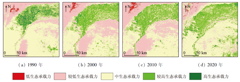
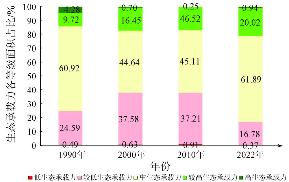
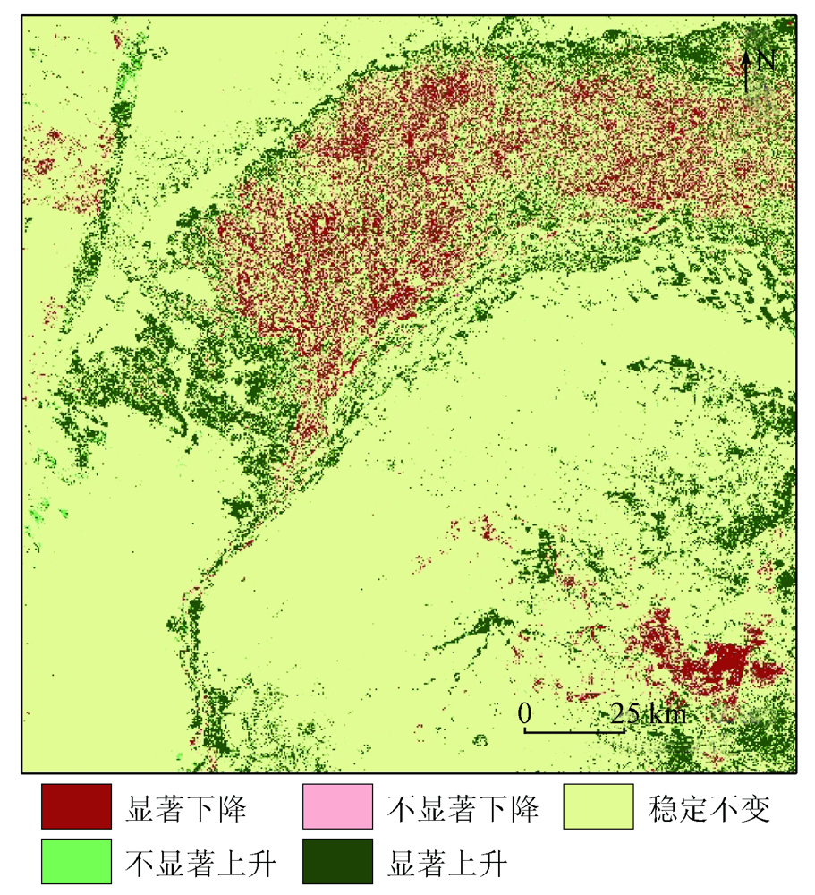
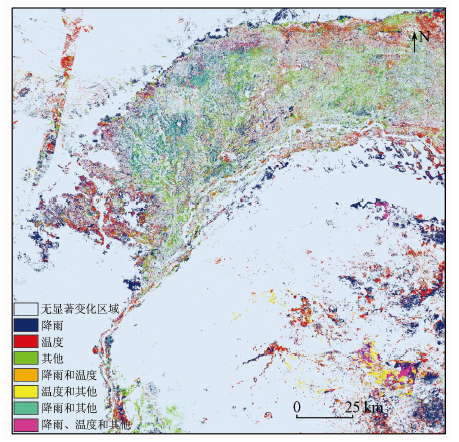
Ecological carrying capacity is an important indicator used to measure the stability of an ecosystem. The spatial-temporal change analysis of the ecological carrying capacity can help understand the changing trend of a regional ecological environment and serve as a comprehensive reference for the evaluation of ecological management and restoration, research on the overall sustainable development of an environment, and the optimization of land resources. Targeting the arid and semi-arid regions at the northeastern margin of the Ulan Buh Desert, this study constructed a comprehensive index evaluation system of ecological carrying capacity based on the actual ecological conditions of the regions and Landsat remote sensing images as the data source. Then, this study determined the spatial-temporal distribution and evolution pattern of regional ecological carrying capacity and made a driver analysis of the change in the ecological carrying capacity from the angles of rainfall, temperature, and land use changes. The results show that the ecological carrying capacity of the northeastern margin of the Ulan Buh Desert showed a first decreasing and then increasing trend from 1990 to 2020. The irrigated areas north of the Yellow River continued to expand to the desertification areas in the southwest. As a result, the percentage of the area with relatively high ecological carrying capacity increased greatly, while the area with high ecological carrying capacity decreased. The change in the ecological carrying capacity of the irrigated areas was mainly affected by land development and utilization, followed by temperature and rainfall. In contrast, the ecological carrying capacity of the desertification areas south of the Yellow River was mainly at a moderate level, which was shifted to a low level in large areas before 2010 and was restored to a moderate level in 2020. The change in the ecological carrying capacity of the desertification areas was greatly affected by temperature, followed by rainfall and changes in shrub and grass vegetation cover.
Qu X Q, Liu M, Li C L, et al. Research progress in ecological carrying capacity assessment methods[J]. Journal of Meteorology and Environment, 2019, 35(4):113-119.
[2]
Du W P, Yan H M, Yang Y Z, et al. Evaluation methods and research trends for ecological carrying capacity[J]. Journal of Resources and Ecology, 2018, 9(2):115-124.
doi: 10.5814/j.issn.1674-764x.2018.02.001
[3]
He Y F, Xie H L. Exploring the spatiotemporal changes of ecological carrying capacity for regional sustainable development based on GIS:A case study of Nanchang City[J]. Technological Forecasting and Social Change, 2019, 148(c):119720.
[4]
Frank J W, Ottfried D, Gunnar L, et al. Evaluation of spatio-temporal patterns of remotely sensed evapotranspiration to infer information about hydrological behaviour in a data-scarce region[J]. Water, 2017, 9(5):333-358.
doi: 10.3390/w9050333
[5]
Tang X G, Ma M G, Ding Z, et al. Remotely monitoring ecosystem water use efficiency of grassland and cropland in China’s arid and semi-arid regions with MODIS data[J]. Remote Sensing, 2017, 9(6):616-633.
doi: 10.3390/rs9060616
Cao Z, Min Q W, Liu M C, et al. Ecological carrying capacity based on ecosystem services:Concept,connotation,evaluation model and application[J]. Journal of Natural Resources, 2015, 30(1):1-11.
Wang M Z. Measures and suggestions for improving salinized cultivated land in Hetao Irrigation District of Inner Mongolia[J]. China Water Resources, 2019, 15:40-41.
Yan J Y, Ma X Y, Wang C X. Problems of protection and management of state-managed water conservancy projects in Hetao Irrigation District and countermeasures[J]. China Water Resources, 2021, 15:58-59.
[9]
杨超. 磴口县荒漠化治理产业业态及地区承载力研究[D]. 呼和浩特: 内蒙古农业大学, 2020.
Yang C. Research on desertification control industry forms and regional carrying capacity in Dengkou County[D]. Hehot: Inner Mongolia Agricultural University, 2020.
Zhang J B, Hao Y G, Liu M H, et al. Dynamic changes of ecological footprint and ecological carrying capacity in Dengkou County,Inner Mongolia[J]. Chinese Agricultural Science Bulletin, 2011, 27(32):168-174.
Liu M H, Zhang J B, Zhang R, et al. Ecological carrying capacity of water resources in Dengkou County in 2007[J]. Chinese Agricultural Science Bulletin, 2011, 27(17):255-259.
[12]
Yang H F, Mu S J, Li J L. Effects of ecological restoration projects on land use and land cover change and its influences on territorial NPP in Xinjiang,China[J]. Catena, 2014, 115:85-95.
doi: 10.1016/j.catena.2013.11.020
[13]
张启斌. 乌兰布和沙漠东北缘生态网络构建与优化研究[D]. 北京: 北京林业大学, 2019.
Zhang Q B. Construction and optimization of ecological network in the northeastern edge of Ulan Buh Desert[D]. Beijing: Beijing Forestry University, 2019.
Bian K, Gao J L, Xin Z M, et al. Research on wind and sand resistance ability of oasis shelterbelt system in the northeastern edge of Ulan Buh Desert[J]. Journal of Capital Normal University, 2021, 42(1):48-53.
Luo F M, Gao J L, Xin Z M, et al. Low-altitude structure characteristics of sandstorms inside and outside the shelterbelt in the northeastern edge of Ulan Buh Desert[J]. Arid Zone Research, 2019, 36(4):1032-1040.
Huang Y R, Ma Y B, Hao Y G, et al. Analysis of soil nutrient characteristics of Nitraria community and Artemisia ordosica community in the northeastern edge of Ulan Buh Desert[J]. Journal of Shandong Agricultural University, 2019, 50(4):559-565.
[17]
Zhen Z J, Chen S B, Yin T G, et al. Using the negative soil adjustment factor of soil adjusted vegetation index (SAVI) to resist saturation effects and estimate leaf area index (LAI) in dense vegetation areas[J]. Sensors (Basel,Switzerland), 2021, 21(6):2115.
doi: 10.3390/s21062115
[18]
Wu Z H, Lei S G, Bian Z F, et al. Study of the desertification index based on the albedo-MSAVI feature space for semi-arid steppe region[J]. Environmental Earth Sciences, 2019, 78(6):232.
doi: 10.1007/s12665-019-8111-9
[19]
Liu Q S, Liu G H, Huan C. Monitoring desertification processes in Mongolian Plateau using MODIS tasseled cap transformation and TGSI time series[J]. Journal of Arid Land, 2018, 10(1):12-26.
doi: 10.1007/s40333-017-0109-0
Lai S Y Z. Study on the comprehensive evaluation of urban human resources industry in Sichuan Province:Based on principal component analysis and cluster analysis[J]. Journal of Wuhan Polytechnic, 2017, 16(5):65-70.
Yu L P, Song X Y, Wang Z G. Research on the impact of evaluation index standardization and evaluation methods on academic evaluation:Taking TOPSIS evaluation method as an example[J]. Information Theory and Practice, 2020, 43(2):15-20.
Yu L P. Study on the impact mechanism of index standardization method on science and technology evaluation:Taking the evaluation of academic journals as an example[J]. Information Theory and Practice, 2020, 43(12):54-62.
Li P W, Li G C, Zhang J H, et al. Several assessment models and application analysis of urban ecological security[J]. Geographical Research, 2009, 28(2):293-302.
doi: 10.11821/yj2009020003
[24]
Tang W, Chen A Z, Li D M, et al. The application of combination weighting approach in multiple attribute decision making[J]. International Conference on Machine Learning and Cybernetics, 2009, 5:2724-2728.
[25]
Karayalcin I I. The analytic hierarchy process:Planning,priority setting,resource allocation[J]. North-Holland, 1982, 9(1):97-98.
Chu C K, Sun S Q, Han F T. The subject service evaluation model of academic libraries based on the analytic hierarchy process[J]. Journal of Academic Libraries, 2014, 32(6):86-90.
Lin X C, Liu R. Evaluation of the carrying capacity of the ecological environment in the coastal waters of Putian City[J]. Journal of Putian University, 2019, 26(2):94-99.
[28]
Wu X L, Hu F. Analysis of ecological carrying capacity using a fuzzy comprehensive evaluation method[J]. Ecological Indicators, 2020, 113:106243.
doi: 10.1016/j.ecolind.2020.106243
[29]
Wang Z F, He X Q, Zhang C, et al. Evaluation of geological and eco-logical bearing capacity and spatial pattern along Du-wen road based on the analytic hierarchy process (AHP) and the technique for order of preference by similarity to an ideal solution (TOPSIS) method[J]. ISPRS International Journal of Geo-Information, 2020, 9(4):237.
doi: 10.3390/ijgi9040237
[30]
张鹏. 基于主成分分析的综合评价研究[D]. 南京: 南京理工大学, 2004.
Zhang P. Research on comprehensive evaluation based on principal component analysis[D]. Nanjing: Nanjing University of Science and Technology, 2004.
Li Q, Hu S X, Wang Z L. Evaluation of comprehensive economic strength of cities in Shanxi Province based on principal component analysis[J]. Foreign Economics and Trade, 2021(4):80-83.
[32]
杨宇. 多指标综合评价中赋权方法评析[J]. 统计与决策, 2006(13):17-19.
Yang Y. Review and analysis of weighting methods in multi-index comprehensive evaluation[J]. Statistics and Decision, 2006(13):17-19.
[33]
Wu X L, Hu F. Analysis of ecological carrying capacity using a fuzzy comprehensive evaluation method[J]. Ecological Indicators, 2020, 113:106243.
doi: 10.1016/j.ecolind.2020.106243
[34]
陈水蓉. 趋势分析在水质管理中的应用研究[D]. 天津: 天津师范大学, 2012.
Chen S R. Research on the application of trend analysis in water quality management[D]. Tianjin: Tianjin Normal University, 2012.
Sun Y J, Liu X F, Ren Z Y, et al. Multi-scale drought characteristics and influencing factors of the Loess Plateau from 1960 to 2016[J]. Geographical Research, 2019, 38(7):1820-1832.
Wang P, Liu Y M. Sen’s slope estimation and Mann-Kendall method in equipment operation trend analysis application[J]. Journal of Wuhan University of Science and Technology, 2014, 37(6):454-457,472.
[37]
Heike H, Hilary B. Trends in extreme precipitation events in the indus river basin and flooding in Pakistan[J]. Atmosphere-Ocean, 2014, 52(1):77-91.
doi: 10.1080/07055900.2013.859124
[38]
汪攀. 时间序列趋势分析及其在预防性维修中的应用[D]. 武汉: 武汉科技大学, 2015.
Wang P. Time series trend analysis and its application in preventive maintenance[D]. Wuhan: Wuhan University of Science and Technology, 2015.
[39]
Tali P A, Bhat M M, Lone F A. Seasonal spatio-temporal variability in temperature over North Kashmir Himalayas using Sen Slope and Mann-Kendall test[J]. Journal of Climatology and Weather Forecasting, 2021, 9(5):288-298.
Qiu L J, Zheng F L, Yin R S. Analysis of the change trend of precipitation and runoff in the Yanhe River Basin from 1952 to 2008[J]. Journal of Soil and Water Conservation, 2011, 25(3):49-53.
Fan M W, Song Q, Wang B. Determination of breviscapine by digital sequence correlation analysis[J]. Chinese Journal of Experimental Formulae, 2008(8):10-12.
 2023, Vol. 35
  ), 谭炳香1,2(