Please wait a minute...
 
自然资源遥感  2024, Vol. 36 Issue (2): 21-26    DOI: 10.6046/zrzyyg.2022440
  综述 本期目录 | 过刊浏览 | 高级检索 |
全国废弃露天矿山采矿用地分布状况与存在问题
邢宇1(), 王静雅2, 杨金中1(), 陈栋1, 杜晓敏1, 郭靖凯1, 宋丽聪2
1.中国自然资源航空物探遥感中心,北京 100083
2.中国地质大学(北京)地球科学与资源学院,北京 100083
Distributions and existing problems of mining land of abandoned open-pit mines in China
XING Yu1(), WANG Jingya2, YANG Jinzhong1(), CHEN Dong1, DU Xiaomin1, GUO Jingkai1, SONG Licong2
1. China Aero Geophysical Survey and Remote Sensing Center for Natural Resources, Beijing 100083, China
2. School of Earth Sciences and Resources, China University of Geosciences (Beijing), Beijing 100083, China
全文: PDF(2255 KB)   HTML  
输出: BibTeX | EndNote (RIS)      
摘要 

为客观获取矿山环境基础数据,采取遥感数据与多源数据相结合、计算机自动信息提取与人机交互解译相结合、室内综合研究与实地调查相结合的技术路线,开展了全国废弃露天开采矿山的采矿损毁土地、生态修复土地监测。2022年遥感监测查明: 全国废弃露天矿山采矿用地面积约82.74万hm2,占全国陆域面积的0.86‰,主要分布在内蒙古自治区、新疆维吾尔自治区、河北省、山东省、黑龙江省等省(自治区)。其中,采矿损毁土地面积约50.74万hm2,生态修复面积约32.00万hm2,生态修复率38.68%。废弃露天矿山采矿用地占用基本农田2.63万hm2,占总面积的3.18%; 位于生态红线内的全国废弃矿山露天采矿用地面积8.09万hm2,占总面积的9.77%。全国与第三次全国国土调查(采矿用地)吻合的废弃矿山露天采矿用地面积累计30.13万hm2,占总面积的36.42%。初步分析了全国废弃矿山露天采矿用地情况、废弃矿山采矿用地占用基本农田情况、生态红线内的废弃矿山采矿用地情况、废弃矿山环境恢复治理土地等遥感工作现状及存在问题,提出对策建议。

服务
把本文推荐给朋友
加入引用管理器
E-mail Alert
RSS
作者相关文章
邢宇
王静雅
杨金中
陈栋
杜晓敏
郭靖凯
宋丽聪
关键词 废弃露天矿山采矿用地矿山生态修复遥感监测    
Abstract

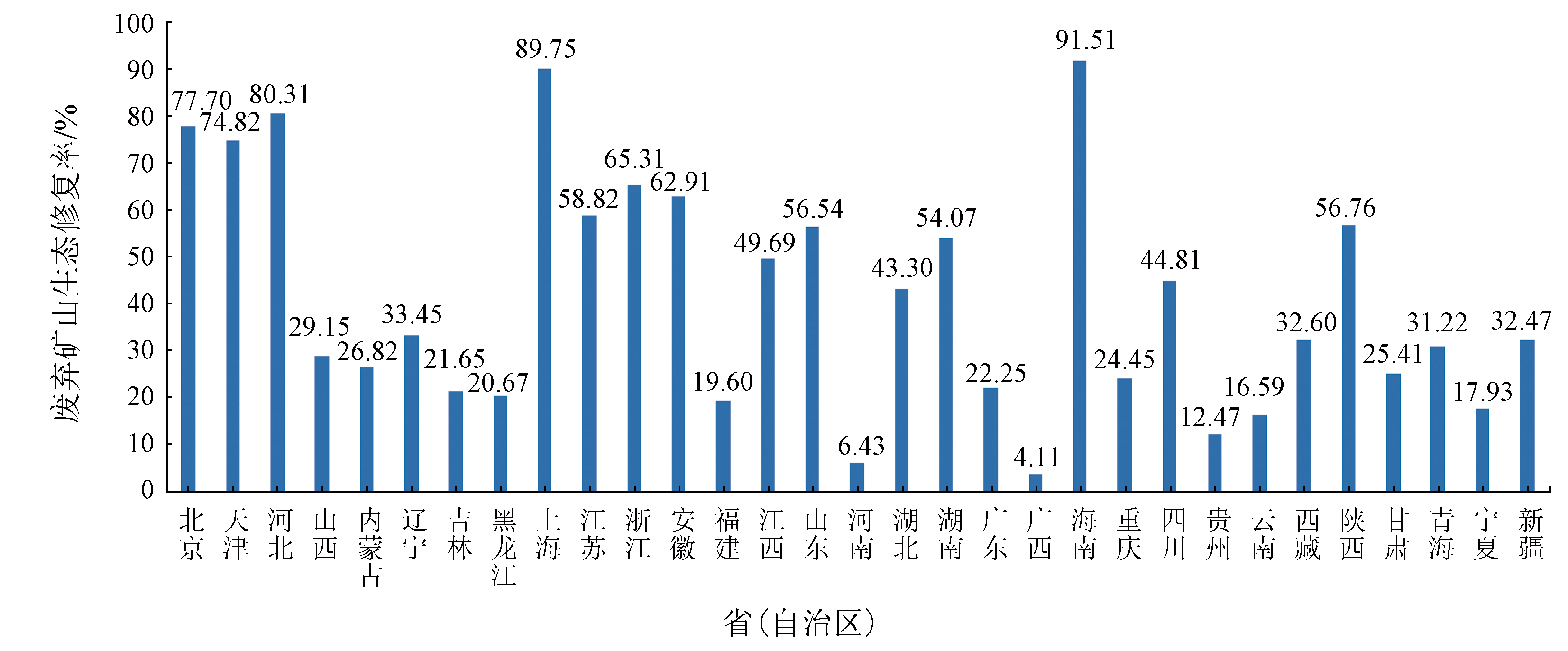
To obtain the fundamental data of mine environments objectively, this study monitored the damaged mining land and the ecological restoration land in abandoned open-pit mines in China by combining remote sensing data with multi-source data, computer automated information extraction with human-computer interactive interpretation, and comprehensive laboratory research with field investigation. The remote sensing monitoring in 2022 shows that the mining land of abandoned open-pit mines in China covered an area of 82.74×10⁴ hm2, representing 0.86‰ of the national land area, primarily distributed in Inner Mongolia and Xinjiang Uygur autonomous regions as well as Hebei, Shandong, and Heilongjiang provinces. Among them, the damaged mining land and the ecological restoration land accounted for 50.74×10⁴ hm2 and 32.00×10⁴ hm2, respectively, with an ecological restoration rate of 38.68%. The mining land of abandoned open-pit mines occupied primary farmland of 2.63×10⁴ hm2, representing 3.18% of the total mining area. The mining land of nationwide abandoned open-pit mines within the ecological red line accounted for 8.09×10⁴ hm2, representing 9.77% of the total mining area. The mining land of nationwide abandoned open-pit mines, coinciding with the result of the third national land resource survey (mining land), totaled 30.13×10⁴ hm2, representing 36.42% of the total mining area. This study preliminarily analyzed the present situation and existing problems of remote sensing work involving the mining land of nationwide abandoned open-pit mines, the occupation of primary farmland, the mining land of such mines within the ecological red line, and corresponding environmental restoration and governance. Finally, this study proposed countermeasures and suggestions in this regard.

Key wordsabandoned open-pit mine    mining land    mine ecological restoration    remote sensing monitoring
收稿日期: 2022-11-17      出版日期: 2024-06-14
ZTFLH:  TP79  
基金资助:地质调查项目“全国矿山开发及重点地区生态空间监测评估”(DD20230100)
通讯作者: 杨金中(1970-),男,博士,研究员,主要从事矿山遥感监测与矿山生态修复等方面的研究。Email: 67786808@qq.com
作者简介: 邢 宇(1982-),女,博士,正高级工程师,主要从事矿山环境生态修复和自然保护地资源环境遥感监测等方面的研究。Email: xingyurs@163.com
引用本文:   
邢宇, 王静雅, 杨金中, 陈栋, 杜晓敏, 郭靖凯, 宋丽聪. 全国废弃露天矿山采矿用地分布状况与存在问题[J]. 自然资源遥感, 2024, 36(2): 21-26.
XING Yu, WANG Jingya, YANG Jinzhong, CHEN Dong, DU Xiaomin, GUO Jingkai, SONG Licong. Distributions and existing problems of mining land of abandoned open-pit mines in China. Remote Sensing for Natural Resources, 2024, 36(2): 21-26.
链接本文:  
https://www.gtzyyg.com/CN/10.6046/zrzyyg.2022440      或      https://www.gtzyyg.com/CN/Y2024/V36/I2/21
省(自治区) 采矿损毁面积 生态修复面积 总面积 省(自治区) 采矿损毁面积 生态修复面积 总面积
北京 1 123.00 3 913.38 5 036.38 湖北 7 879.62 6 017.04 13 896.66
天津 1 543.22 4 586.69 6 129.91 湖南 10 852.65 12 774.15 23 626.80
河北 14 293.87 58 312.15 72 606.02 广东 16 786.85 4 802.83 21 589.68
山西 26 012.80 10 704.42 36 717.22 广西 21 420.92 917.30 22 338.22
内蒙古 60 316.96 22 104.65 82 421.61 海南 793.34 8 546.94 9 340.28
辽宁 28 892.20 14 524.30 43 416.50 重庆 3 449.54 1 116.51 4 566.05
吉林 15 142.87 4 184.23 19 327.10 四川 4 630.97 3 759.82 8 390.79
黑龙江 44 895.89 11 700.81 56 596.70 贵州 8 544.35 1 217.05 9 761.40
上海 57.31 501.64 558.95 云南 23 291.47 4 631.20 27 922.67
江苏 12 761.81 18 226.00 30 987.81 西藏 5 585.00 2 700.97 8 285.97
浙江 4 926.82 9 275.53 14 202.35 陕西 5 838.10 7 663.11 13 501.21
安徽 8 164.09 13 845.53 22 009.62 甘肃 18 292.15 6 229.99 24 522.14
福建 12 015.85 2 929.74 14 945.59 青海 12 792.89 5 806.55 18 599.44
江西 10 113.76 9 988.84 20 102.60 宁夏 14 595.43 3 189.24 17 784.67
山东 28 650.13 37 267.97 65 918.10 新疆 55 316.15 26 592.57 81 908.72
河南 28 386.44 1 949.75 30 336.19 合计 507 366.45 319 980.90 827 347.35
Tab.1  全国废弃露天矿山采矿用地统计
Fig.1  全国废弃矿山露天采矿用地生态修复情况对比
[1] 国土资源部. 全国矿产资源规划(2016—2020)[R]. 北京: 国土资源部, 2016.
Ministry of Land and Resources. National mineral resource planning(2016—2020)[R]. Beijing: Ministry of Land and Resources, 2016.
[2] 白中科, 周伟, 王金满, 等. 再论矿区生态系统恢复重建[J]. 中国土地科学, 2018, 32(11):1-9.
Bai Z K, Zhou W, Wang J M, et al. Rethink on ecosystem restoration and rehabilitation of mining areas[J]. China Land Science, 2018, 32(11):1-9.
[3] 杨金中, 聂洪峰, 荆青青. 初论全国矿山地质环境现状与存在问题[J]. 国土资源遥感, 2017, 29(2):1-7.doi:10.6046/gtzyyg.2017.02.01.
Yang J Z, Nie H F, Jing Q Q. Preliminary analysis of mine geo-environment status and existing problems in China[J]. Remote Sensing for Land and Resources, 2017, 29(2):1-7.doi:10.6046/gtzyyg.2017.02.01.
[4] 杨金中, 许文佳, 姚维岭, 等. 全国采矿损毁土地分布与治理状况及存在问题[J]. 地学前缘, 2021, 28(4):83-89.
doi: 10.13745/j.esf.sf.2020.10.8
Yang J Z, Xu W J, Yao W L, et al. Land destroyed by mining in China:Damage distribution,rehabilitation status and existing problems[J]. Earth Science Frontiers, 2021, 28(4):83-89.
[5] 杨金中, 秦绪文, 张志, 等. 矿山遥感监测理论方法与实践[M]. 北京: 测绘出版社, 2011.
Yang J Z, Qin X W, Zhang Z, et al. Theory and practice on remote sensing monitoring of mine[M]. Beijing: Sino Maps Press, 2011.
[6] 杨金中, 秦绪文, 聂洪峰, 等. 中国矿山遥感监测[M]. 北京: 测绘出版社, 2014.
Yang J Z, Qin X W, Nie H F, et al. Remote sensing monitoring of mine in China[M]. Beijing: Sino Maps Press, 2014.
[7] 中华人民共和国国土资源部. DZ/T 0266—2014 矿产资源开发遥感监测技术规范[S]. 北京: 中国标准出版社, 2014.
Ministry of Land and Resources,People’s Republic of China. DZ/T 0266—2014. Regulation on remote sensing monitoring of mining exploration[S]. Beijing: China Standard Press, 2014.
[8] 杨金中, 王晓红, 王海庆, 等. 中国矿山地质环境遥感监测—2017年[M]. 北京: 地质出版社, 2019.
Yang J Z, Wang X H, Wang H Q, et al. Remote sensing monitoring of mine geological environment in China 2017[M]. Beijing: Geological Publishing House, 2019.
[9] 张进德, 郗富瑞. 我国废弃矿山生态修复研究[J]. 生态学报, 2020, 40(21):7921-7930.
Zhang J D, Xi F R. Study on ecological restoration of abandoned mines in China[J]. Acta Ecologica Sinica, 2020, 40(21):7921-7930.
[10] 鞠建华. 构建中国绿色矿山建设的支撑体系[J]. 中国矿业, 2020, 29(1):13-15.
Ju J H. Building the support system of green mine construction in China[J]. China Mining Magazine, 2020, 29(1):13-15.
[1] 和海霞, 李博. 青海大通“8·18”山洪灾害特征及风险分析[J]. 自然资源遥感, 2024, 36(2): 135-141.
[2] 马晓雪, 焦润成, 曹颖, 南赟, 王晟宇, 郭学飞, 赵丹凝, 闫驰, 倪璇. 重大工程建设中地质灾害综合遥感监测技术方法应用——以北京2022冬奥会延庆赛区为例[J]. 自然资源遥感, 2024, 36(2): 248-256.
[3] 周小迦. 丘陵地带耕地撂荒遥感监测应用研究[J]. 自然资源遥感, 2024, 36(1): 235-241.
[4] 于航, 安娜, 汪洁, 邢宇, 许文佳, 步凡, 王晓红, 杨金中. 黔西南采煤塌陷区高分遥感动态监测——以六盘水市煤矿采空塌陷区为例[J]. 自然资源遥感, 2023, 35(3): 310-318.
[5] 李星佑, 张飞, 王筝. 土壤盐渍化遥感监测模型构建方法现状与发展趋势[J]. 自然资源遥感, 2022, 34(4): 11-21.
[6] 王娟, 王志红, 张建国, 初娜, 李斯, 尹展. 河南省国家级自然保护区人类活动遥感监测及其影响强度评价[J]. 自然资源遥感, 2022, 34(4): 235-242.
[7] 辛荣芳, 李宗仁, 张焜, 张兴, 黄丽, 刘宝山. 青海省湟水流域地质灾害动态变化遥感监测[J]. 自然资源遥感, 2022, 34(4): 254-261.
[8] 陈艳英, 马鑫程, 徐彦平, 王颖, 汪艳波. 地形及NDVI在林火遥感监测二次识别中应用的方法探讨[J]. 自然资源遥感, 2022, 34(3): 88-96.
[9] 董双发, 范晓, 石海岗, 许莉萍, 章新益. 基于Landsat8和无人机的福清核电温排水分布研究[J]. 自然资源遥感, 2022, 34(3): 112-120.
[10] 查东平, 蔡海生, 张学玲, 何庆港. 基于多时相Sentinel-1水稻种植范围提取[J]. 自然资源遥感, 2022, 34(3): 184-195.
[11] 佟晶, 杨金中, 杜鑫, 杜晓敏, 李春博, 安娜. 污染地块土地治理与开发利用遥感监测——以浙江省风险管控与修复名录地块为例[J]. 自然资源遥感, 2022, 34(3): 235-239.
[12] 左璐, 孙雷刚, 鲁军景, 徐全洪, 刘剑锋, 马晓倩. 基于MODIS的京津冀地区生态质量综合评价及其时空变化监测[J]. 自然资源遥感, 2022, 34(2): 203-214.
[13] 吕品, 熊丽媛, 徐争强, 周学铖. 基于FME的矿山遥感监测矢量数据图属一致性检查方法[J]. 自然资源遥感, 2022, 34(1): 293-298.
[14] 陈栋, 姚维岭. 基于ArcPy与定制ArcToolbox的矿山新增图斑自动编号及方法改进[J]. 国土资源遥感, 2021, 33(2): 262-269.
[15] 刁明光, 刘文静, 李静, 刘芳, 王彦佐. 矿山遥感监测矢量成果数据动态变化检测方法[J]. 国土资源遥感, 2020, 32(3): 240-246.
Viewed
Full text


Abstract

Cited

  Shared   
  Discussed   
京ICP备05055290号-2
版权所有 © 2015 《自然资源遥感》编辑部
地址:北京学院路31号中国国土资源航空物探遥感中心 邮编:100083
电话:010-62060291/62060292 E-mail:zrzyyg@163.com
本系统由北京玛格泰克科技发展有限公司设计开发