Impacts of changes in land cover on solar radiation absorption in northwestern China
SHI Ying1(), BIE Qiang1,2,3(), SU Xiaojie1, LI Xinzhang1
1. Faculty of Geomatics, Lanzhou Jiaotong University, Lanzhou 730070, China 2. National-Local Joint Engineering Research Center of Technologies and Applications for National Geographic State Monitoring, Lanzhou 730070, China 3. Gansu Provincial Engineering Laboratory for National Geographic State Monitoring, Lanzhou 730070, China
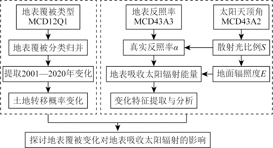
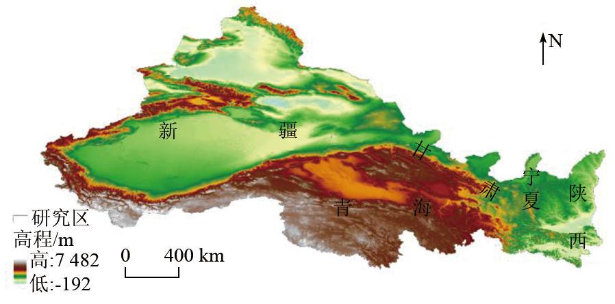
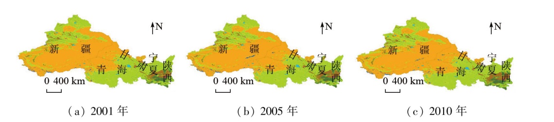
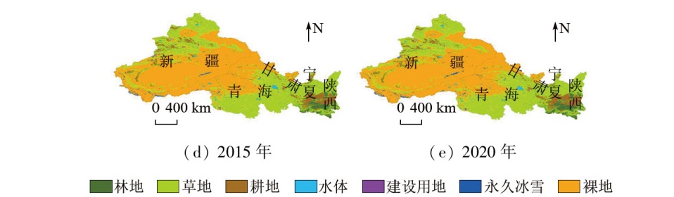
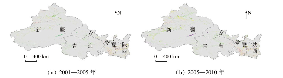
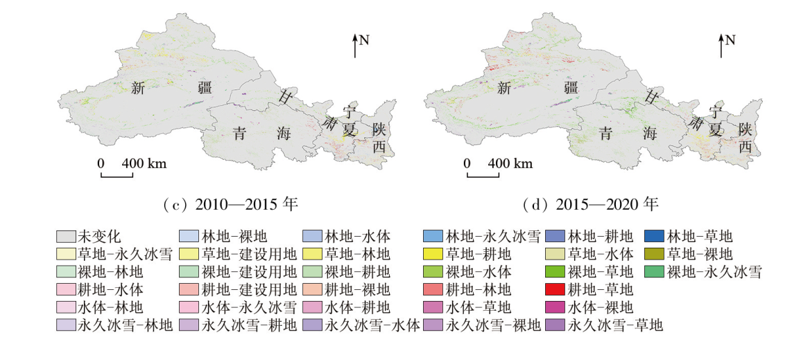
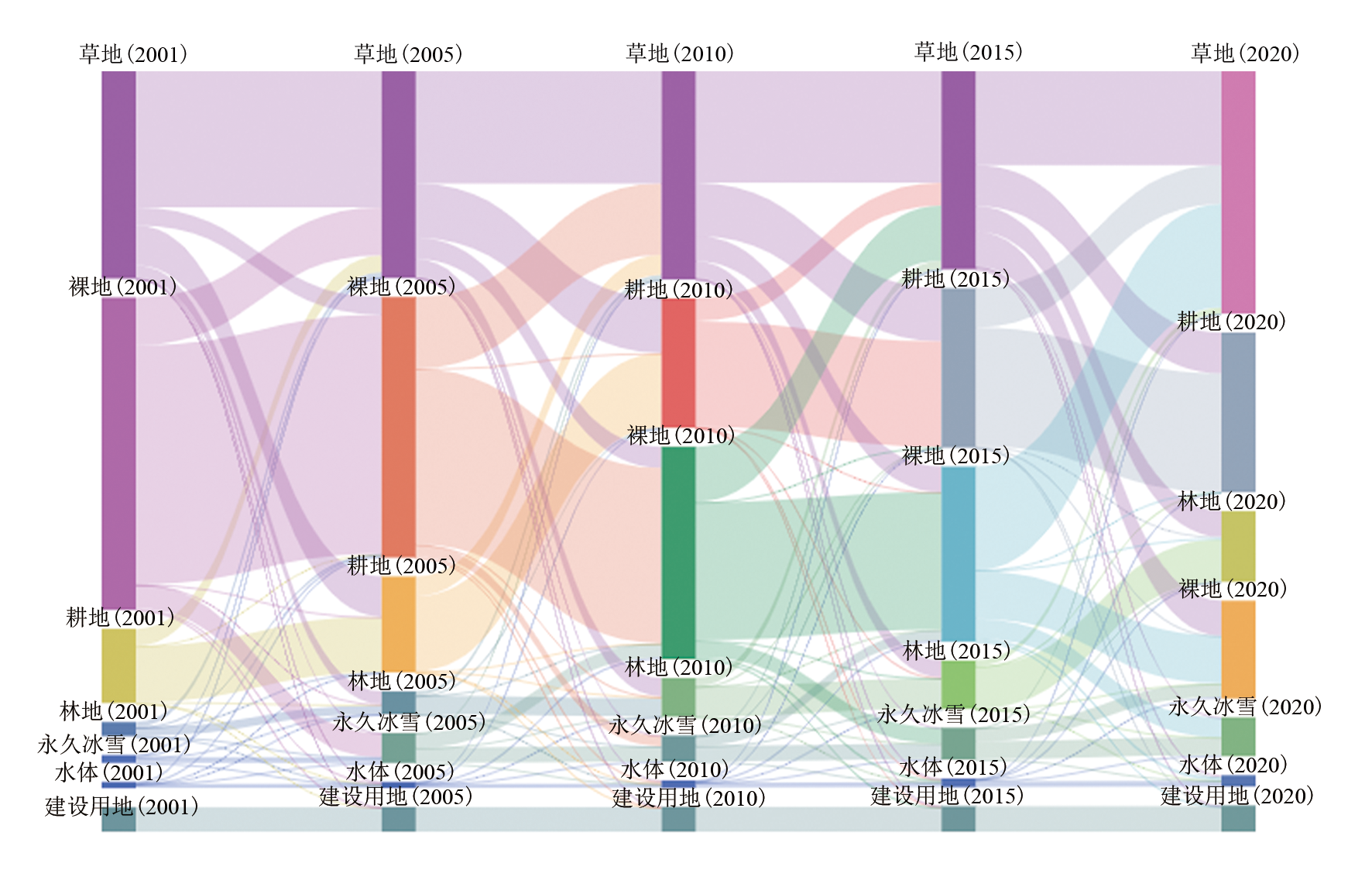
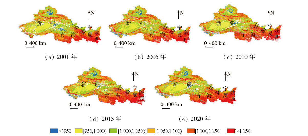
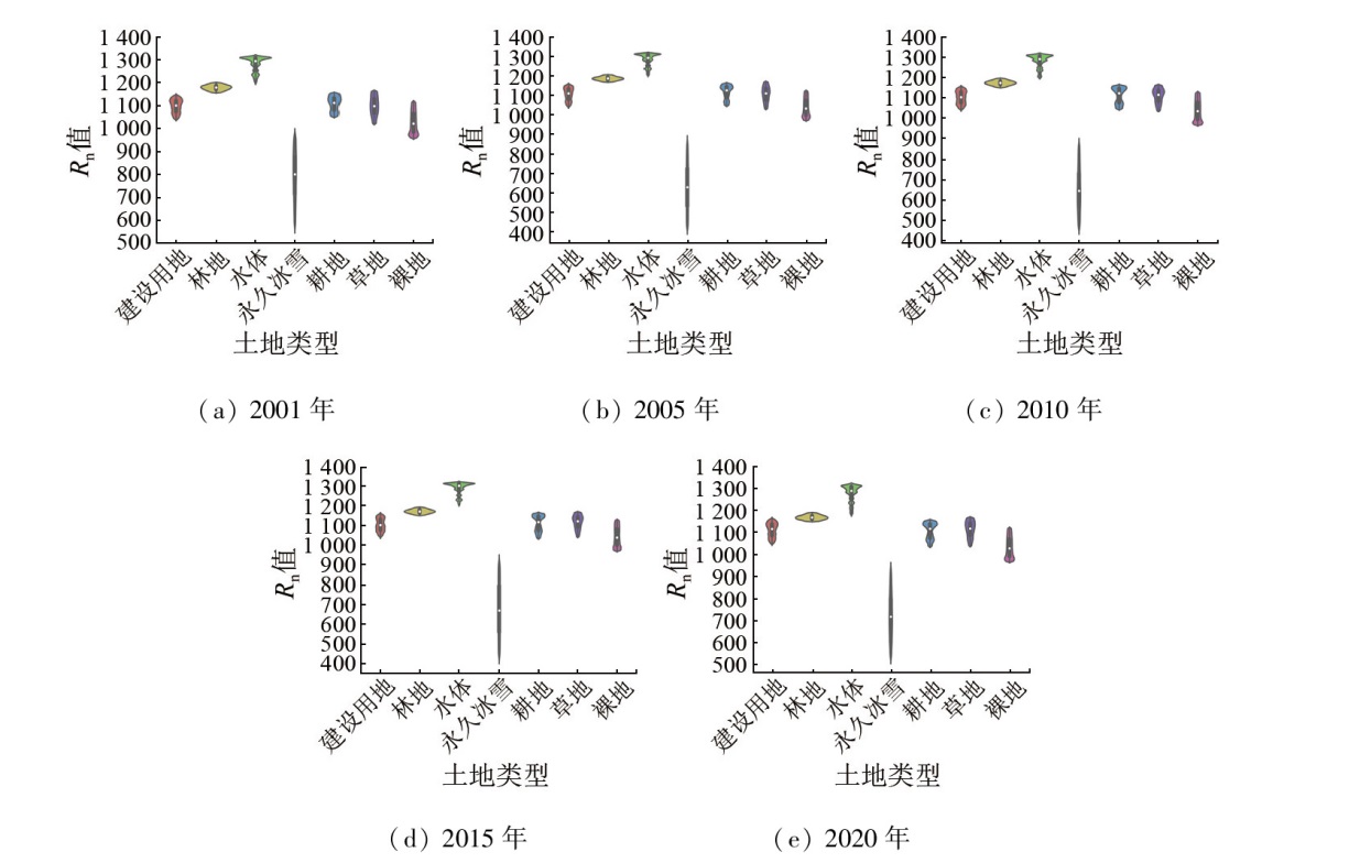
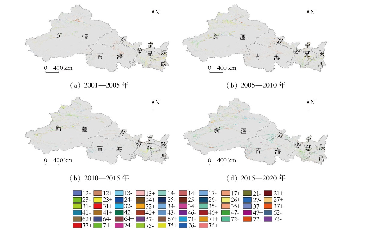
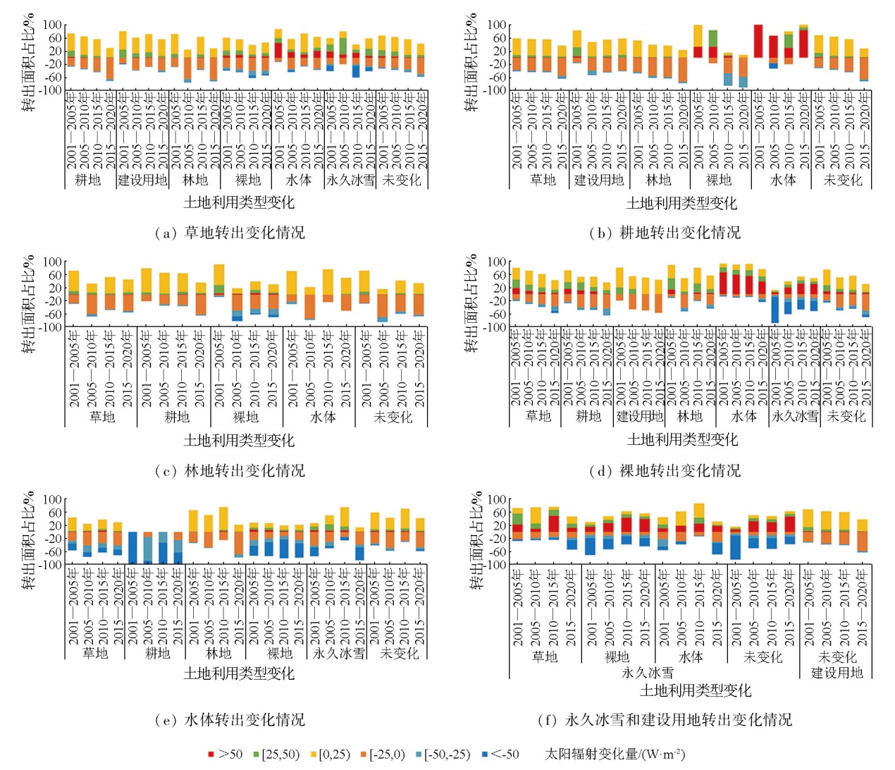
The changes in land cover types will affect the amount of solar radiant energy absorbed by the land surface and then influence the radiative equilibrium of the surface ecosystem. Under the background of dramatic changes in land cover, the patterns and changes of the solar radiation absorptivity of land exert significant influence on the thermal equilibrium of the land surface. Based on the MODIS MCD12Q1 land cover data, the MCD43A3 surface albedo data, and the MCD43A2 solar zenith angle data from 2001 to 2020, along with two adjacent phases of spatiotemporal changes in the surface cover types and the solar radiant energy absorbed by land surface across northwestern China, this study analyzed and explored the impacts of the changes in land cover types on solar radiation absorption. The results indicate that the changes in land cover types in the study area are primarily characterized by reduced bare land area and the expansion of other land cover types, with the largest areal change occurring in the shift from bare land to grassland. Different types of land cover display varying solar radiation absorptivities. Water bodies exhibit the greatest solar radiation absorptivity, followed by woodland, cultivated land, grassland, and construction land, with bare land and permanent ice and snow presenting the poorest solar radiation absorptivities. The conversion of land cover types will lead to different radiation absorptivities. Specifically, the transfer from grassland, cultivated land, bare land, and permanent ice and snow primarily exhibits an increasing trend in solar radiation absorptivity, while that of water bodies and forest land largely displays a decreasing trend. The same land cover type differs in the time series of solar radiation absorption, which primarily increases for construction land, grassland, cultivated land, bare land, and water bodies but decreases for woodland and permanent ice and snow. The results of this study will provide a scientific basis and reference for research on climatic change, ecological construction, and sustainable development in northwestern China.
石莹, 别强, 苏晓杰, 李欣璋. 中国西北地区地表覆被变化对太阳辐射吸收的影响[J]. 自然资源遥感, 2024, 36(4): 260-271.
SHI Ying, BIE Qiang, SU Xiaojie, LI Xinzhang. Impacts of changes in land cover on solar radiation absorption in northwestern China. Remote Sensing for Natural Resources, 2024, 36(4): 260-271.
Zhang Y, Ji X R, Wang M. Just transition in climate regime:Concept development and governance progress[J]. Climate Change Research, 2021, 17(2):245-254.
[2]
Searchinger T, Hanson C, Ranganathan J, et al. Creating a sustainable food future:A menu of solutions to sustainably feed more than 9 billion people by 2050[J]. World Resources Report, 2013.
[3]
IPCC. Fourth assessment report (AR4).Climate change 2007:The physical science basis[R]. New York: Cambridge University Press, 2007.
Li Y P, Cai H, Tian P J, et al. Changes in ecosystem carbon stock caused by land cover conversion in Liping County of Guizhou Province[J]. Bulletin of Soil and Water Conservation, 2020, 40(2):92-99,325.
[5]
Metz B, Davidson O R, Bosch P R, et al. Climate change 2007:Mitigation.contribution of working group III to the fourth assessment report of the intergovernmental panel on climate change[J]. Computational Geometry, 2007, 18(2):95-123.
[6]
Searchinger T D, Wirsenius S, Beringer T, et al. Assessing the efficiency of changes in land use for mitigating climate change[J]. Nature, 2018, 564(7735):249-253.
[7]
杨骁. 宁夏中南部地区土地利用变化与生态脆弱性响应[D]. 银川: 宁夏大学, 2022.
Yang X. Land use change and ecological vulnerability response in central and southern Ningxia[D]. Yinchuan: Ningxia University, 2022.
Song Q F. Study on impact of forest resource dynamic change on forest ecological function in recent 40 years in China[D]. Beijing: Chinese Academy of Forestry, 2015.
Mao J T, Xu W T, Xie Z Q. Trends and hotspots of forest carbon sinks based on the knowledge map[J]. Acta Ecologica Sinica, 2023, 43(19):8241-8253.
[10]
Ma H Y, Zhang L L, Wei X Q, et al. Spatial and temporal variations of land use and vegetation cover in Southwest China from 2000 to 2015[J]. The Journal of Applied Ecology, 2021, 32(2):618-628.
Wu X, Min M, Dong L X. Estimation and diurnal variation analysis of clear-sky surface longwave radiation fluxes from Himawari08 satellite[J]. Climatic and Environmental Research, 2018, 23(1):37-46.
Shen Y B, Zhao Z C, Shi G Y. The progress in variation of surface solar radiation,factors and probable climatic effects[J]. Advances in Earth Science, 2008, 23(9):915-923.
[13]
权维俊. 中国大陆地区地表净太阳辐射的卫星遥感研究[D]. 南京: 南京气象学院, 2003.
Quan W J. Satellite remote sensing study on net surface solar radiation on the surface of Chinese mainland area[D]. Nanjing University of Information Science Technology, 2003.
Chen F Y. Study on land use/cover change and its effects of natural environment elements in Hubei Province[D]. Wuhan: Huazhong Agricultural University, 2009.
[15]
Williamson S N, Barrio I C, Hik D S, et al. Phenology and species determine growing-season albedo increase at the altitudinal limit of shrub growth in the sub-Arctic[J]. Global Change Biology, 2016, 22(11):3621-3631.
doi: 10.1111/gcb.13297
pmid: 27158930
[16]
Brovkin V, Raddatz T, Reick C H, et al. Global biogeophysical interactions between forest and climate[J]. Geophysical Research Letters, 2009, 36(7):L07405.
Feng Q, Bai G Z, Li Z X, et al. Accelerate construction of new pattern of ecological protection in Northwest China[J]. Bulletin of Chinese Academy of Sciences, 2022, 37(10):1457-1470.
Cao Y Q, Lu J. Research status and frontier analysis of meteorological drought at domestic and abroad[J]. China Flood & Drought Management, 2021, 31(3):1-7.
Wei Z F, Ren Z Y, Zhang C, et al. Changes of vegetation cover and its correlation with precipitation and temperature in Northwest China[J]. Bulletin of Soil and Water Conservation, 2014, 34(3):283-289.
Zhai J, Liu R G, Liu J Y, et al. Radiative forcing over China due to albedo change caused by land cover change during 1990—2010[J]. Acta Geographica Sinica, 2013, 68(7):875-885.
[21]
王倩. 基于土地覆被变化的秦淮地区辐射强迫研究[D]. 西安: 西安科技大学, 2019.
Wang Q. Study on radiative forcing of land cover change in Qinhuai area[D]. Xi’an: Xi’an University of Science and Technology, 2019.
Du Y B. The interaction between land surface and atmospheric boundary layer in northwest region and its response to the summer monsoon[D]. Lanzhou: Lanzhou University, 2018.
Jiang T L, Su X L, Guo S M, et al. Spatiotemporal variation of vegetation water consumption and its response to meteorological drought in Northwest China[J]. Journal of Hydraulic Engineering, 2021, 52(2):229-240.
Chen S Y, Xing X B, Zhang K L, et al. Climatic characteristics of gross solar radiation over Northwestern China[J]. Resources Science, 2010, 32(8):1444-1451.
Li X D. Spatial-temporal variability of soil moisture and influencing factors in northwest arid area of China[D]. Beijing: Research Center for Eco-Environmental Sciences,University of Chinese Academy of Sciences, 2019.
[26]
苗文辉. 西北地区植被变化对中国夏季气候的影响[D]. 兰州: 兰州大学, 2018.
Miao W H. Effects of vegetation changes in Northwest China on summer climate in China[D]. Lanzhou: Lanzhou University, 2018.
Li X J, Xin X Z, Peng Z Q. Change analysis of surface solar radiation in China from 2003 to 2012[J]. Acta Energiae Solaris Sinica, 2017, 38(11):3057-3066.
Liu Q P, Zhu C, Tian H Z, et al. Spatio-temporal changes in cultivated land and their influencing factors in China based on MODIS data[J]. Journal of Lanzhou University(Natural Sciences), 2022, 58(5):689-697.
[29]
Peng S S, Piao S, Zeng Z, et al. Afforestation in China cools local land surface temperature[J]. Proceedings of the National Academy of Sciences of the United States of America, 2014, 111(8):2915-2919.
[30]
Luyssaert S, Jammet M, Stoy P C, et al. Land management and land-cover change have impacts of similar magnitude on surface temperature[J]. Nature Climate Change, 2014, 4(5):389-393.
[31]
Li Y, Zhao M, Motesharrei S, et al. Local cooling and warming effects of forests based on satellite observations[J]. Nature Communications, 2015, 6:6603.
doi: 10.1038/ncomms7603
pmid: 25824529
[32]
Lewis P, Barnsley M J. Influence of the sky radiance distribution on various formulations of the Earth surface albedo[J]. International Symposium on Physical Measurements and Signatures in Remote Sensing Isprs,1994.
[33]
Stokes G M, Schwartz S E. The atmospheric radiation measurement (ARM) program:Programmatic background and design of the cloud and radiation test bed[J]. Bulletin of the American Meteorological Society, 1994, 75(7):1201-1221.
Cao M C, Lin Z H, Zhang H. A modeling study of the response of radiative forcing and climate to solar constant variation in boreal winter[J]. Advances in Meteorological Science and Technology, 2014, 4(4):38-43.
Liu B, Zhang Q Q, Xin H Q, et al. Dynamic change monitoring on surface cover in Tarim River Basin during 2000 to 2014[J]. Science of Surveying and Mapping, 2018, 43(5):45-49.
Hu Y F, Shang L J, Zhang Q L, et al. Land change patterns and driving mechanism in Beijing since 1990 based on GEE platform[J]. Remote Sensing Technology and Application, 2018, 33(4):573-583.
Yao Y B, Zheng S Z, Dong H C, et al. Anomaly temporal-spatial distribution of solar radiation in Northwest China[J]. Arid Zone Research, 2023, 40(6):863-873.
doi: 10.13866/j.azr.2023.06.02
Gao J, Feng P F, Zhang H F, et al. Detection method of surface cover type change based on active and passive remote sensing technology:A case study of the west Tianshan national nature reserve in Xinjiang[J]. Journal of Northwest Forestry University, 2020, 35(4):140-147.
Liu X Y, Zhong P F. Study on the evolution of land use and landscape pattern in northwest China Based on GIS:Taking Lanzhou City of Gansu Province as an example[J]. Landscape Architecture Academic Journal, 2021, 38(4):89-97.
Ma M, Zhang S W, Wei B C. Temporal and spatial pattern of grassland degradation and its determinants for recent 30 years in Xilingol[J]. Chinese Journal of Grassland, 2017, 39(4):86-93.
Cheng Q H. A study of the scale effect of the relationship between urban sky view factor on surface temperature[D]. Beijing: Beijing University of Civil Engineering and Architecture, 2022.
 2024, Vol. 36
  ), 别强1,2,3(