Land subsidence caused by groundwater level recovery in Taiyuan City
TANG Wei1(), YAN Zhuangzhuang2, WANG Yiming1(), XU Fangfang1, WU Xuanyu1
1. School of Geoscience and Surveying Engineering, China University of Mining and Technology (Beijing), Beijing 100083, China 2. State Key Laboratory of Information Engineering in Surveying, Mapping and Remote Sensing, Wuhan University, Wuhan 430079, China
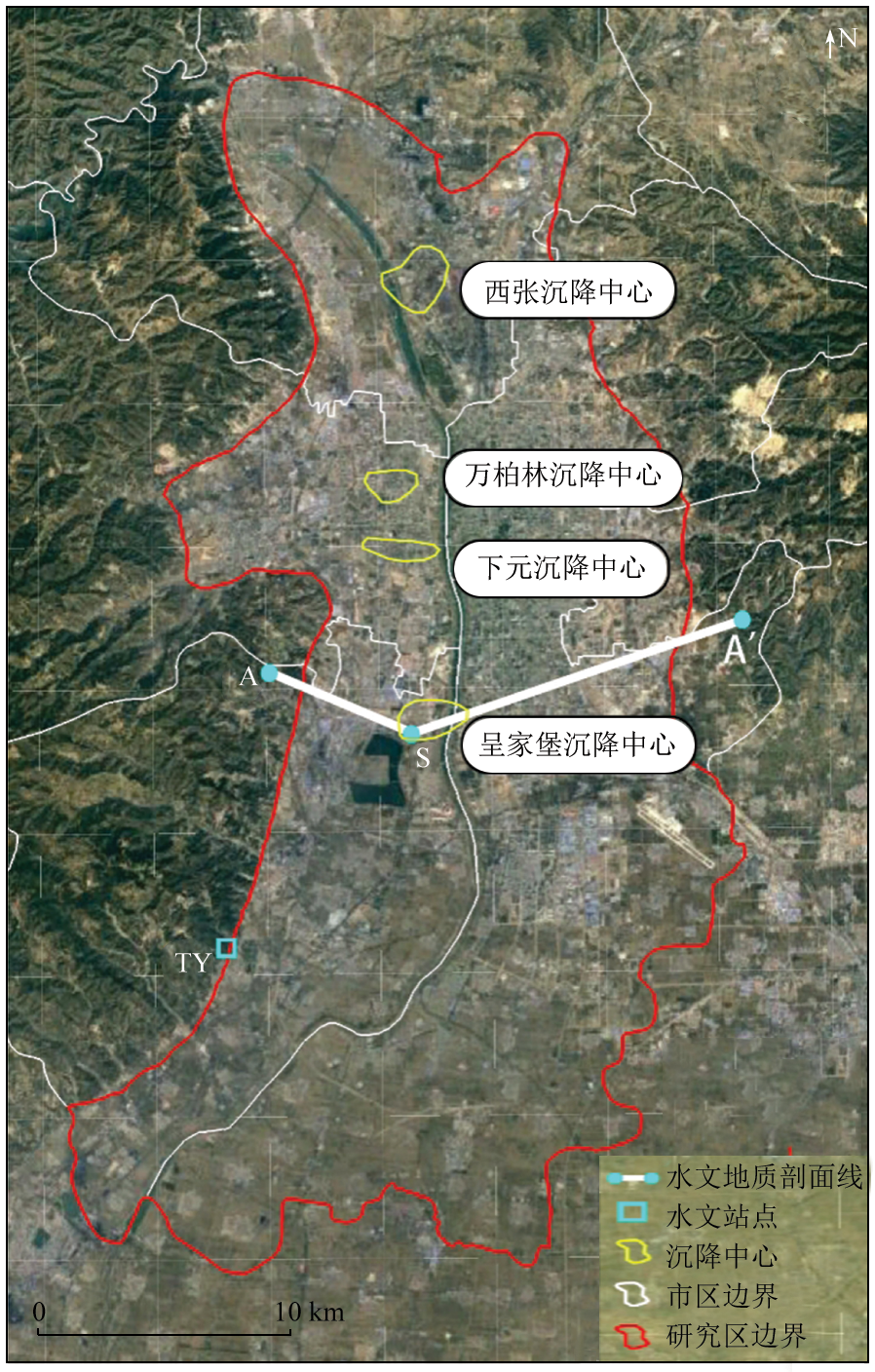
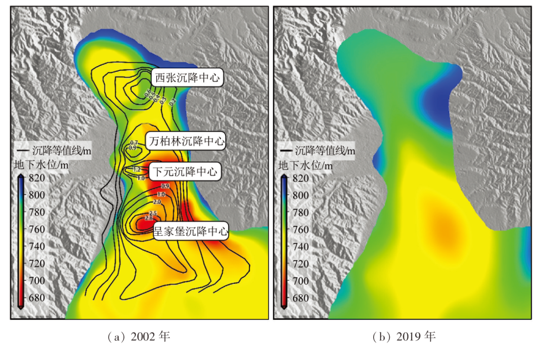
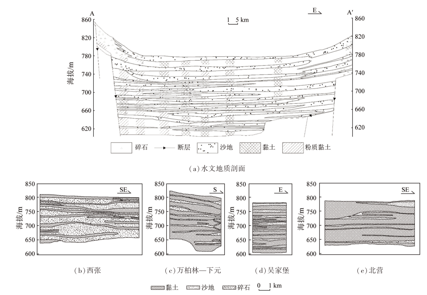
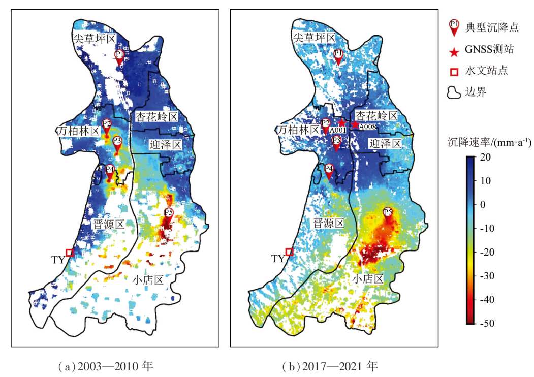
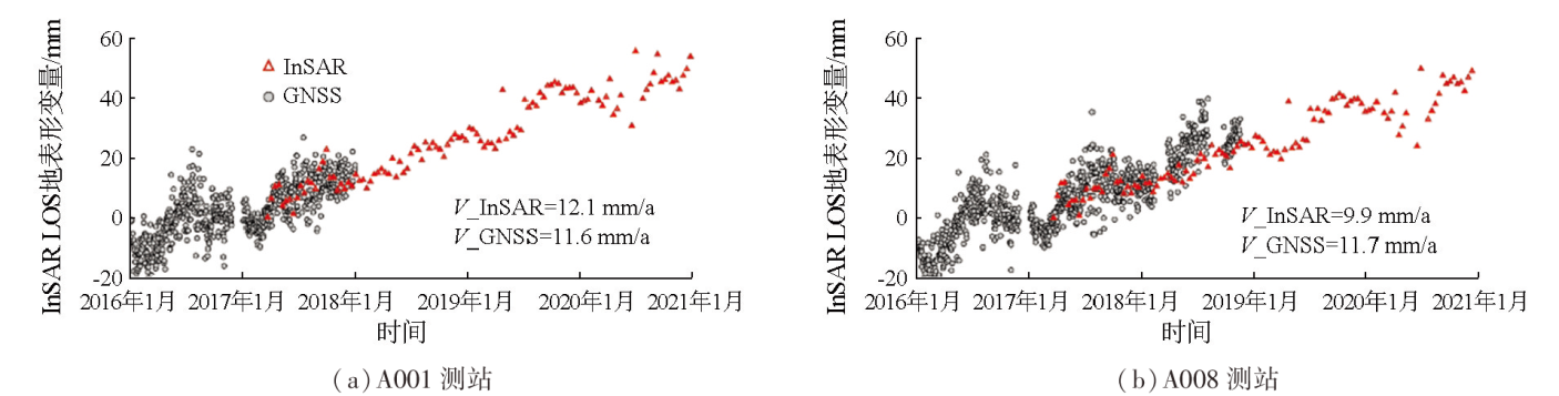
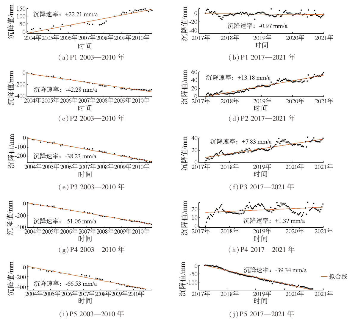
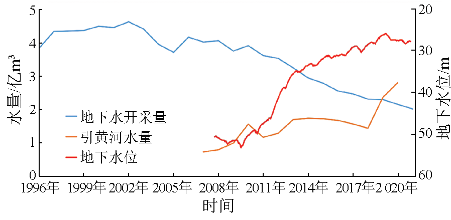
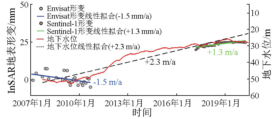
Over the past few decades, excessive groundwater exploitation has led to a significant decrease in the groundwater level and serious land subsidence in Taiyuan City. In recent years, Taiyuan has vigorously implemented strict groundwater management measures and the project of water diversion into Shanxi from the Yellow River, substantially alleviating groundwater overexploitation and gradually recovering groundwater levels in the city. Therefore, it is necessary to scientifically assess the effect of groundwater level revovery on land subsidence. Based on 2003—2010 synthetic aperture radar (SAR) data from ENVISAT and 2017—2021 SAR data from Sentinel-1, this study extracted the land subsidence information of Taiyuan City of both periods using persistent scatterer interferometric SAR (PS-INSAR). Accordingly, this study compared and analyzed the temporal evolution of land subsidence during the two periods by combining the groundwater extraction volumes, water volumes diverted from the water diversion project, and data on groundwater levels. The results show that the land subsidence in Taiyuan City has been significantly mitigated, with the urban area having shifted from subsidence to uplift. In the Xiaodian area, which underwent the most serious land subsidence, the subsidence area expanded. Nevertheless, the overall land subsidence rate decreased, and the subsidence center has moved southward. The main cause for the slowdown of the land subsidence and even the land uplift in Taiyuan is the continuous groundwater level recovery attributed to the reduced groundwater exploitation and the water diversion project. The results of this study provide a scientific basis for fine-scale land subsidence prevention and groundwater management in Taiyuan City under conditions of groundwater level recovery.
Water Resources Department of Shanxi Province. Emergency water source planning in severe drought year in Shanxi Province[M]. Beijing: China Water and Power Press, 2009.
Sun X H, Peng J B, Cui X M, et al. Relationship between ground fissures,groundwater exploration and land subsidence in Taiyuan Basin[J]. The Chinese Journal of Geological Hazard and Control, 2016, 27(2):91-98.
Sun Z Y, Ma T, Ma J, et al. Effect of strata heterogeneity on spatial pattern of land subsidence in Taiyuan City[J]. Rock and Soil Mechanics, 2007, 28(2):399-403,408.
Cui Z D, Tang Y Q. Domestic and international recent situation and research of land subsidence disasters[J]. China Earthquake Engineering Journal, 2007(3):275-278,292.
Shi M, Gong H L, Chen B B, et al. Monitoring of land subsidence in Beijing-Tianjin-Hebei Plain during 2016—2018 based on InSAR and Sentinel-1A data[J]. Remote Sensing for Natural Resources, 2021, 33(4):55-63.doi:10.6046/zrzyyg.2020341.
Yu W, Gong H L, Chen B B, et al. Spatial-temporal evolution characteristics and prediction of land subsidence in the eastern plain of Beijing[J]. Remote Sensing for Natural Resources, 2022, 34(4):183-193.doi:10.6046/zrzyyg.2021390.
Tang W, Zhao X J, Kang C Q, et al. Monitoring land subsidence by time series InSAR and wavelet analysis of seasonal deformation in Taiyuan Basin[J]. Chinese Journal of Geophysics, 2023, 66(6):2352-2369.
[9]
Ferretti A, Prati C, Rocca F. Permanent scatterers in SAR interferometry[J]. IEEE Transactions on Geoscience and Remote Sensing, 2001, 39(1):8-20.
Li D R, Liao M S, Wang Y. Progress of permanent scatterer interferometry[J]. Geomatics and Information Science of Wuhan University, 2004(8): 664-668.
[11]
Ferretti A, Prati C, Rocca F. Nonlinear subsidence rate estimation using permanent scatterers in differential SAR interferometry[J]. IEEE Transactions on Geoscience and Remote Sensing, 2000, 38(5):2202-2212.
[12]
Lanari R, Mora O, Manunta M, et al. A small-baseline approach for investigating deformations on full-resolution differential SAR interferograms[J]. IEEE Transactions on Geoscience and Remote Sensing, 2004, 42(7):1377-1386.
[13]
Berardino P, Fornaro G, Lanari R, et al. A new algorithm for surface deformation monitoring based on small baseline differential SAR interferograms[J]. IEEE Transactions on Geoscience and Remote Sensing, 2002, 40(11): 2375-2383.
[14]
Hooper A, Segall P, Zebker H. Persistent scatterer interferometric synthetic aperture radar for crustal deformation analysis,with application to Volcán Alcedo,Galápagos[J]. Journal of Geophysical Research:Solid Earth, 2007, 112(B7):B07407.
[15]
Hilley G E, Bürgmann R, Ferretti A, et al. Dynamics of slow-moving landslides from permanent scatterer analysis[J]. Science, 2004, 304(5679):1952-1955.
pmid: 15218146
Yang G H, Jiang Z S, Liu G Y, et al. Possible relation of horizontal movement field in North China to Kunlun Mountain Ms8.1 earthquake[J]. Journal of Geodesy and Geodynamics, 2007, 27(2):10-15.
[17]
Perissin D, Ferretti A. Urban-target recognition by means of repeated spaceborne SAR images[J]. IEEE Transactions on Geoscience and Remote Sensing, 2007, 45(12):4043-4058.
Wu H A, Zhang Y H, Chen X Y, et al. Ground deformation monitoring using small baseline DInSAR technique:A case study in Taiyuan City from 2003 to 2009[J]. Chinese Journal of Geophysics, 2011, 54(3):673-680.
[21]
Hooper A, Zebker H, Segall P, et al. A new method for measuring deformation on volcanoes and other natural terrains using InSAR persistent scatterers[J]. Geophysical Research Letters, 2004, 31(23):L23611.
Xiao J X. The water level rose 3.17 meters to rank 4th in the country! Taiyuan tightens the valve of groundwater overexploitation[N]. Taiyuan Daily, 2021-03-29.
 2025, Vol. 37
  ), 闫壮壮2, 王一鸣1(