Emerging risk assessment of areas subject to land subsidence in the southern plain of Tianjin, China
YU Hairuo1,2,3(), GONG Huili4,5,6,7,8,9(), CHEN Beibei4,5,6,7,8,9, ZHOU Chaofan4,5,6,7,8,9
1. School of Public Administration, Shandong Technology and Business University,Yantai 264005, China 2. Key Laboratory of Surveying and Mapping Science and Geospatial Information Technology of MNR, CASM, Beijing 100039, China 3. State Key Laboratory of Geo-Information Engineering, Xi’an 710054, China 4. College of Resource Environment and Tourism, Capital Normal University, Beijing 100048, China 5. The Key Lab of Resource Environment and GIS of Beijing, Capital Normal University, Beijing 100048, China 6. Base of the State Key Laboratory of Urban Environmental Process and Digital Modeling, Capital Normal University, Beijing 100048, China 7. Key Laboratory of 3D Information Acquisition and Application, MOE, Capital Normal University, Beijing 100048, China 8. Key Laboratory of Mechanism, Prevention and Mitigation of Land Subsidence, MOE, Capital Normal University, Beijing 100048, China 9. Beijing Laboratory of Water Resources Security, Capital Normal University, Beijing 100048, China
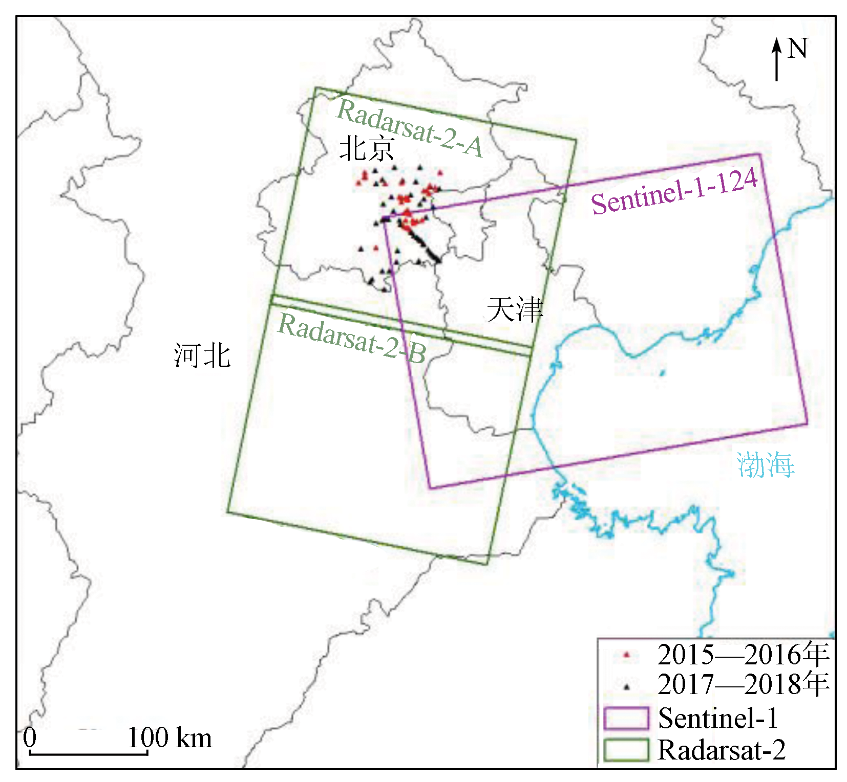
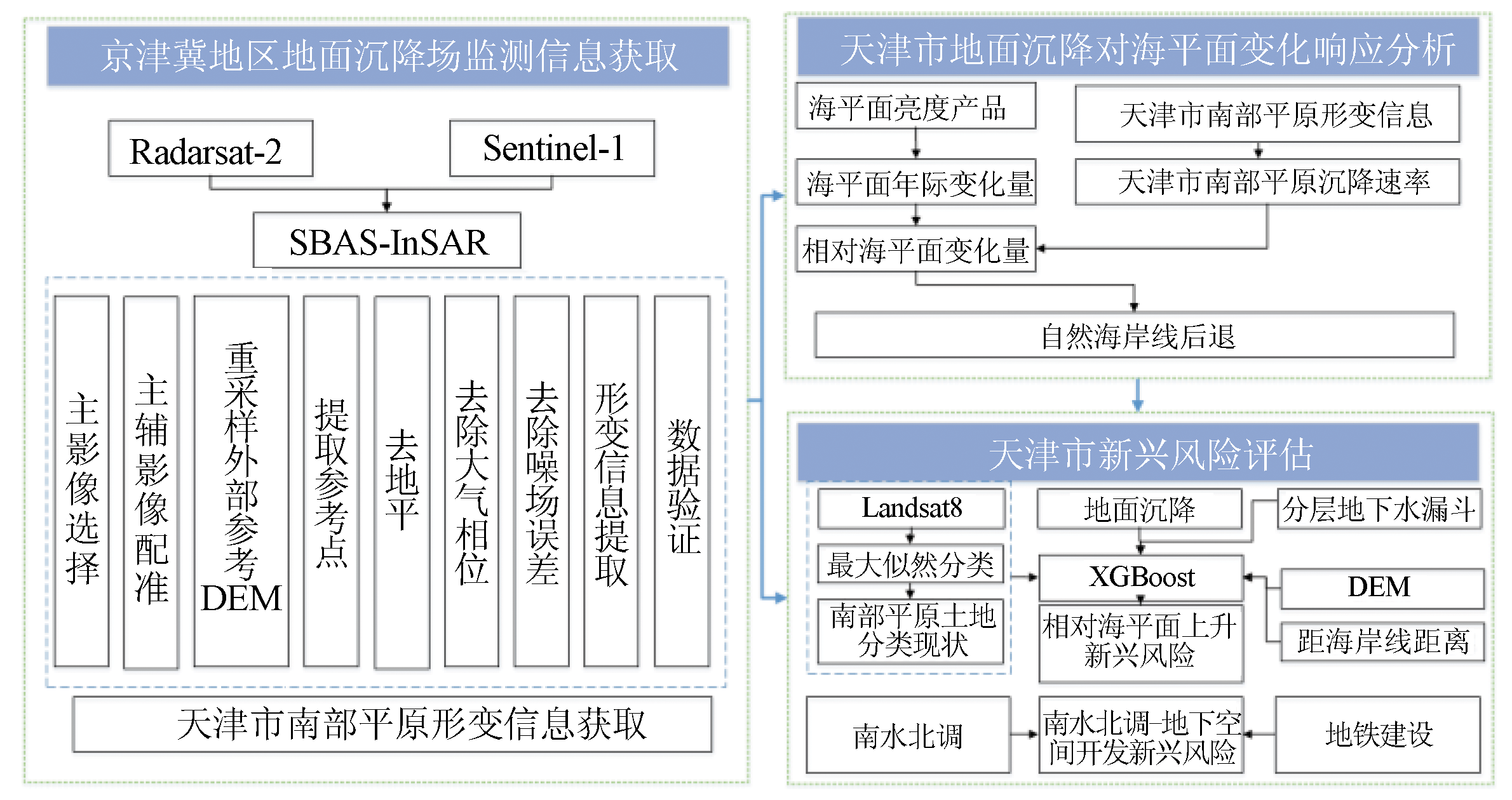
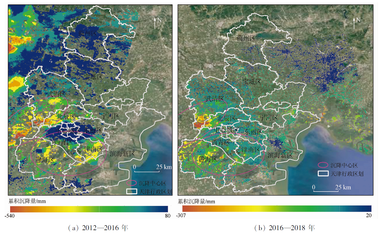
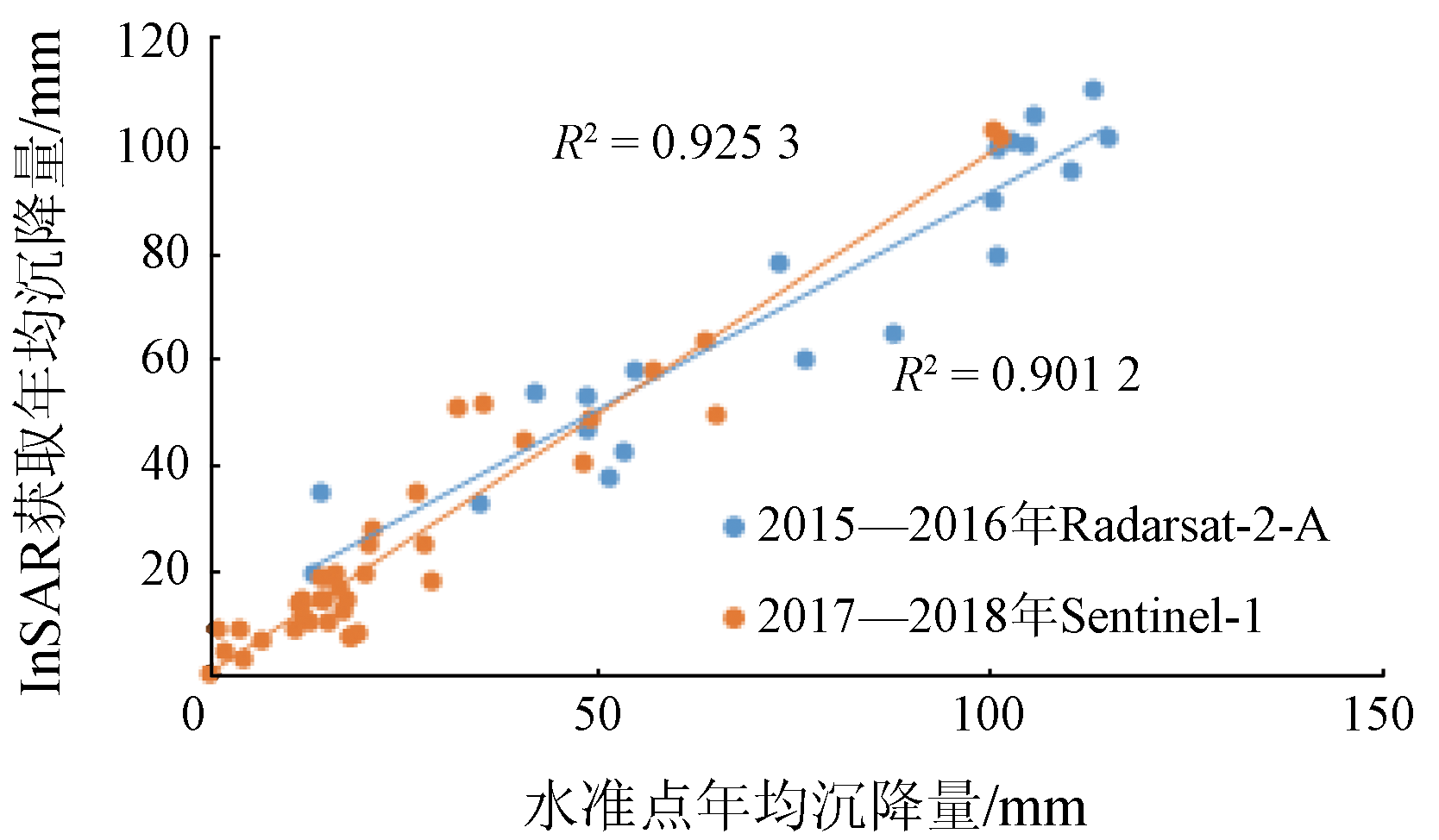
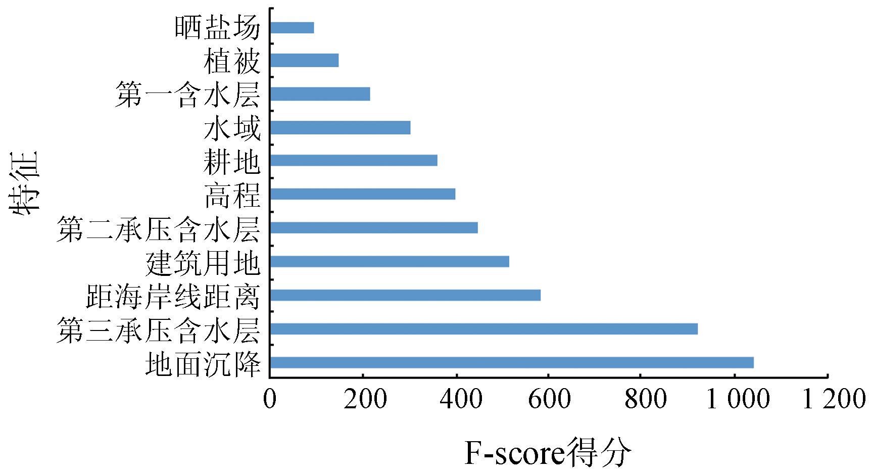
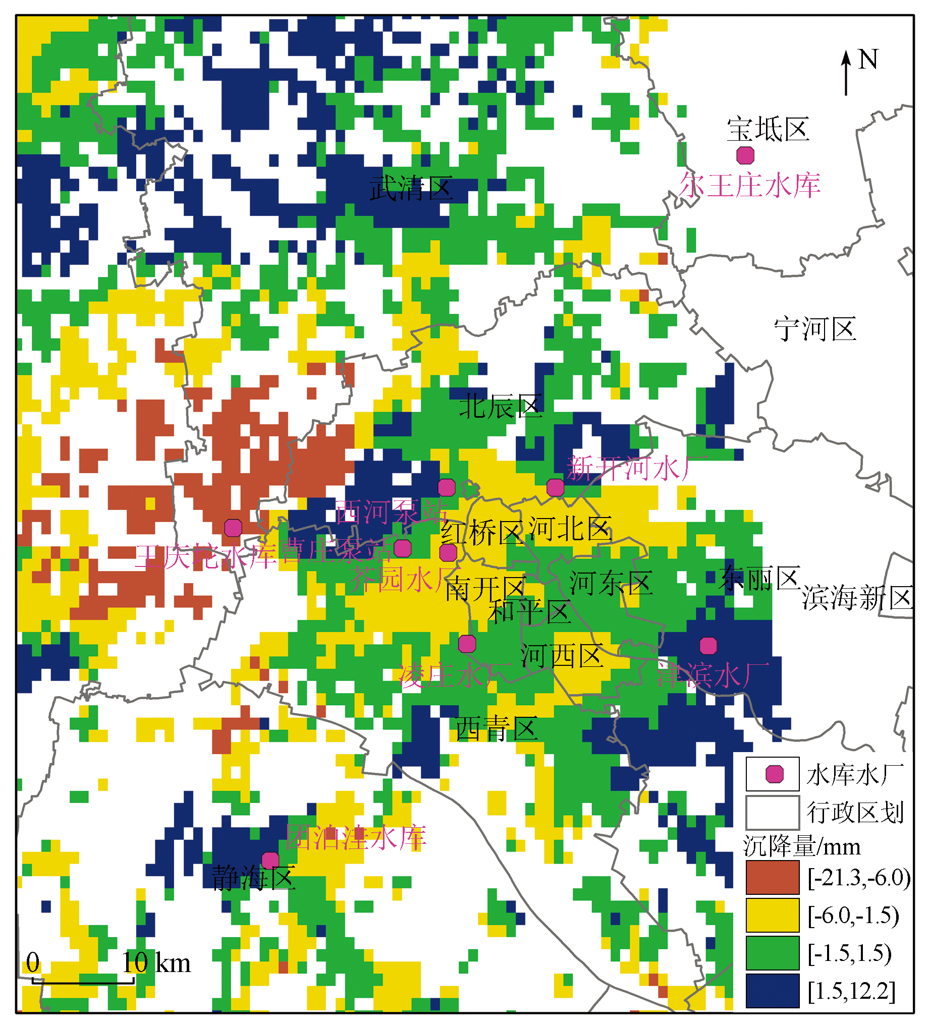
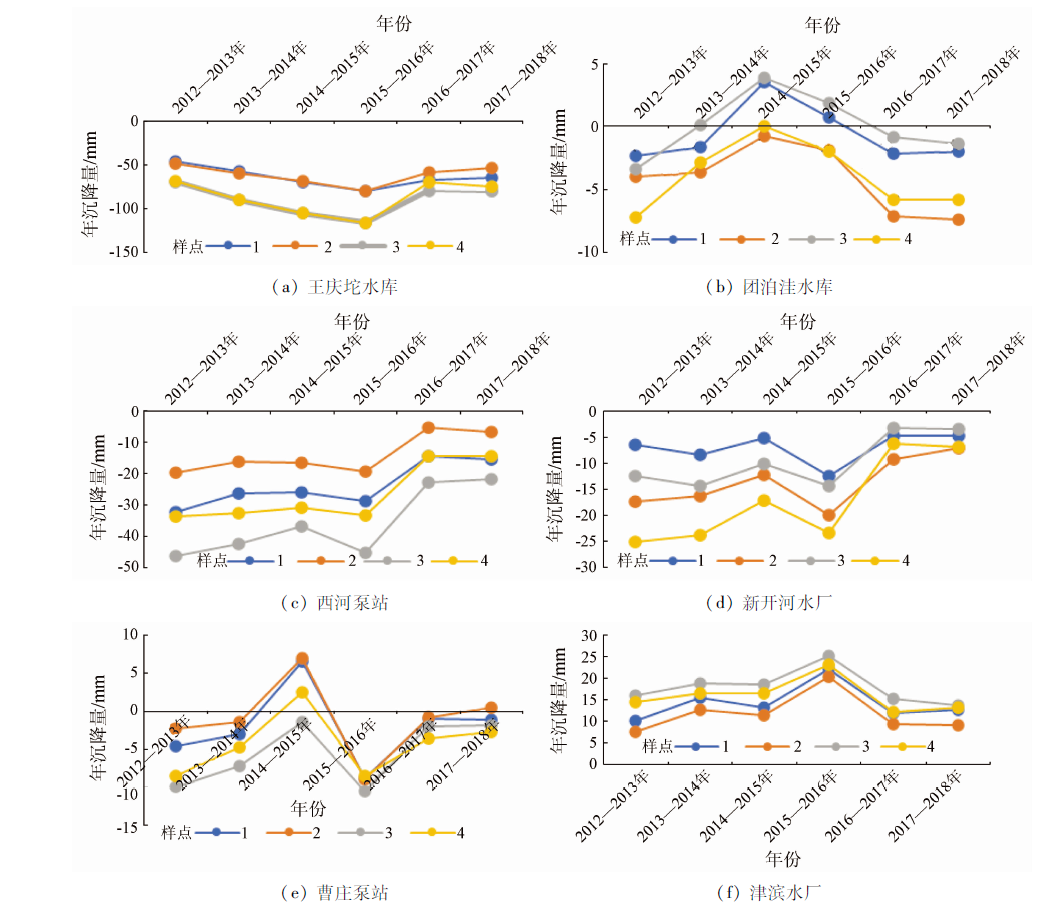
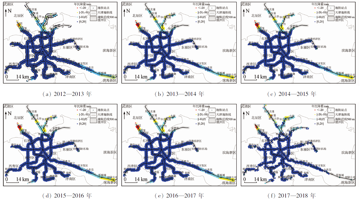
The development of emerging technologies poses some risks while improving urban construction and human life, thus further causing urban safety problems. Tianjin is a coastal city in China, where the coastal sea level keeps increasing, water cycling is changed by the water supply of the South-to-North Water Diversion Project, and the underground space is subject to development and utilization. These factors, coupled with land subsidence, are all critical for the assessment of emerging risks in Tianjin. This study extracted information on the land subsidence of the southern plain in Tianjin and then predicted the retreat of the natural coastline in Tianjin by combining the sea level rise rate. Accordingly, this study predicted the high-risk factors brought by relative sea level rise in Tianjin using a machine learning method (XGBoost). In addition, this study analyzed the emerging risks caused by the South-to-North Water Diversion Project and the development and utilization of underground space and revealed the response patterns of the water supply and the construction and operation of subways to the urban safety of Tianjin. The study on the emerging risks brought about by the combination of land subsidence and modern human activities will provide a scientific basis for regional disaster prevention and mitigation and improve cities’ ability to resist disasters.
于海若, 宫辉力, 陈蓓蓓, 周超凡. 天津市南部平原地面沉降区新兴风险评估[J]. 自然资源遥感, 2023, 35(2): 182-192.
YU Hairuo, GONG Huili, CHEN Beibei, ZHOU Chaofan. Emerging risk assessment of areas subject to land subsidence in the southern plain of Tianjin, China. Remote Sensing for Natural Resources, 2023, 35(2): 182-192.
Yu H R, Gong H L, Chen B B, et al. Emerging risks and the prospect of urban underground space security based on InSAR -GRACE satellite under the new hydrological background[J]. Remote Sensing for Land and Resources, 2020, 32(4):16-22.doi:10.6046/gtzyyg.2020.04.03.
doi: 10.6046/gtzyyg.2020.04.03
Lyu C Z, Liu K X. Analysis of land subsidence characteristics along subway in Tianjin[J]. Beijing Surveying and Mapping, 2020, 34 (9):3.
[4]
Cole G. A discussion on problems associated with the subsidence of southeastern England:The east coast and London tidal flood warning systems[J]. Philosophical Transactions of the Royal Society of London, 1972, 272(1221):173-178.
[5]
Mazzotti S, Lambert A, Kooij M V D. Impact of anthropogenic subsidence on relative sea-level rise in the Fraser River delta[J]. Geology, 2009, 37(9):771-774.
doi: 10.1130/G25640A.1
[6]
Mazzotti S, Lambert T, Kooij M V D. Coastal subsidence and relative sea-level rise in the Fraser River delta,Greater Vancouver,BC,from a combined CTM-InSAR,GPS,leveling,and tide gauge analysis[C]// AGU Fall Meeting Abstracts, 2008.
[7]
Esra E, Cristian R. The worsening impacts of land reclamation assessed with Sentinel-1:The Rize (Turkey) test case[J]. International Journal of Applied Earth Observation and Geoinformation, 2006(74):57-64.
[8]
Miller K G, Sugarman P J, Browning J V. Sea-level rise in New Jersey over the past 5000 years:Implications to anthropogenic changes[J]. Global and Planetary Change, 2009, 66(1-2):10-18.
doi: 10.1016/j.gloplacha.2008.03.008
[9]
Sannekevan A, Gilles E, Esther S, et al. The relative contribution of peat compaction and oxidation to subsidence in built-up areas in the Rhine-Meuse delta,the Netherlands[J]. Science of the Total Environment, 2018(636):177-191.
[10]
Sun H, Grandstaff D, Shagam R. Land subsidence due to groundwater withdrawal:Potential damage of subsidence and sea level rise in southern New Jersey[J]. USA.Environmental Geology, 1999, 37(4):290-296.
[11]
Abidin H Z, Andreas H, Gamal M. Land subsidence characteristics of the Jakarta basin (Indonesia) and its relation with groundwater extraction and sea level rise[J]. Groundwater Response to Changing Climate, 2010(1):113-130.
[12]
Abidin H Z, Andreas H, Gumilar I. Land subsidence of Jakarta (Indonesia) and its relation with urban development[J]. Natural Hazards, 2011, 59(3):1753-1771.
doi: 10.1007/s11069-011-9866-9
[13]
Abidin H Z, Andreas H, Gumilar I. On correlation between urban development,land subsidence and flooding phenomena in Jakarta[J]. IAHS-AISH Proceedings and Reports, 2015, 370:15-20.
Xie C N, Xu S Y, Hu B B, et al. Assessment of land subsidence influence on storm surge risk in Tianjin Binhai area[J]. World Regional Studies, 2009, 18 (4):126-133.
Zhang Y H, Ding W, He J, et al. Risk analysis of hazard-pregnant environment in Brahmaputra based on XGBoost[J]. Journal of Yangtze River Scientific Research Institute, 2021, 3(9):1-10.
Gong S Y, Kong X G, Liu D, et al. An approach for predicting shield construction ground surface settlement of complex stratum using dynamical strata identification[J]. Chinese Journal of Scientific Instrument, 2019, 40(6):228-236.
Lin B J, Liu X D, Yang C, et al. Avalanche susceptibility assessment of highway based on XGBoost machine learning model and GIS technology[J]. Highway, 2020, 65(7):20-26.
[19]
Zhao T A, Zheng S H, Li W L, et al. A study of the credit risk analysis based on XGBoost[J]. Software Engineering, 2018, 21(6):29-32.
[20]
Guo L, Gong H L, Zhu F. Analysis of the spatiotemporal variation in land subsidence on the Beijing plain,China[J]. Remote Sensing, 2019, 11(10):1170.
doi: 10.3390/rs11101170
Bai Z C, Jin G W, Zhang H M, et al. Subsidence monitoring of Tianjin using PS-InSAR technique with Sentinel-1A[J]. Journal of Geomatics Science and Technology, 2017, 34(3):6.
Shao J P. Discussion on expanding the scope of dampproof defense line in the east of Tianjin and perfecting the dampproof system[J]. Haihe Water Conservancy, 2019(1):18-19,29.
Wang W, Wang M, Wei J S, et al. Relationship between the middle route of South-to-North Water Diversion Project and land subsidence control in Tianjin[J]. South-to-North Water Diversion and Water Science and Technology, 2012, 10(3):22-26.
 2023, Vol. 35
  ), 宫辉力4,5,6,7,8,9(