Please wait a minute...
 
自然资源遥感  2025, Vol. 37 Issue (2): 96-107    DOI: 10.6046/zrzyyg.2023356
  技术应用 本期目录 | 过刊浏览 | 高级检索 |
基于多源卫星数据亚东河流域冰湖溃决灾害危险性分析
朱登新1,2,3(), 涂杰楠1(), 孙海冰1,2, 韩振傑1,2, 童立强1, 郭兆成1, 余江宽1, 阎书豪1, 贺鹏1, 朱俊杰4
1.中国自然资源航空物探遥感中心,北京 100083
2.中国地质大学(北京)工程技术学院, 北京 100083
3.黄河勘测规划设计研究院有限公司,郑州 450003
4.菏泽黄河河务局牡丹黄河河务局,菏泽 274009
Hazard assessment of potential glacial lake outburst floods in the Yadong River basin based on multisource satellite data
ZHU Dengxin1,2,3(), TU Jienan1(), SUN Haibing1,2, HAN Zhenjie1,2, TONG Liqiang1, GUO Zhaocheng1, YU Jiangkuan1, YAN Shuhao1, HE Peng1, ZHU Junjie4
1. China Aero Geophysical and Remote Sensing Center of Natural Resources, Beijing 100083, China
2. College of Engineering and Technology, China University of Geosciences(Beijing), Beijing 100083, China
3. Yellow River Engineering Consulting Co., Ltd., Zhengzhou 450003, China
4. Yellow River Mudan Bureau, Heze 274009, China
全文: PDF(8207 KB)   HTML  
输出: BibTeX | EndNote (RIS)      
摘要 近年来,随着全球气候变暖,青藏高原冰川消退,导致冰湖迅速扩张,冰湖溃决灾害的威胁日趋严重,位于西藏自治区日喀则市的亚东河流域分布着大量冰湖,1940 年流域内穷比吓玛错溃决对下游40 km外的亚东县城造成严重影响,部分房屋倒塌,基础设施被毁,在该流域开展冰湖溃决危险性评价对于保护人民生命财产安全具有重要意义。针对冰湖溃决灾害的调查评价,基于高分卫星数据和Landsat系列遥感影像,通过遥感解译获取冰川、冰湖、冰碛物等基础要素。结果表明亚东河流域共分布冰川 28 条,总面积为34.03 km2,共分布冰湖 228 个,总面积为7.79 km2,近 30 a来呈冰川小幅退缩、冰湖小幅扩张的趋势。采用层次分析法和模糊综合评判结合遥感提取要素对区域冰湖的危险性进行了初步评价,得到区域危险性冰湖分布情况,评价结果表明亚东河流域共分布潜在危险冰湖15个,其中高危险性冰湖5个、中危险性冰湖8个、低危险性冰湖2个,主要分布在流域的东北部和西北部高山区,为冰湖溃决灾害风险评价提供科学依据。
服务
把本文推荐给朋友
加入引用管理器
E-mail Alert
RSS
作者相关文章
朱登新
涂杰楠
孙海冰
韩振傑
童立强
郭兆成
余江宽
阎书豪
贺鹏
朱俊杰
关键词 冰湖溃决灾害遥感危险性评价亚东河流域    
Abstract

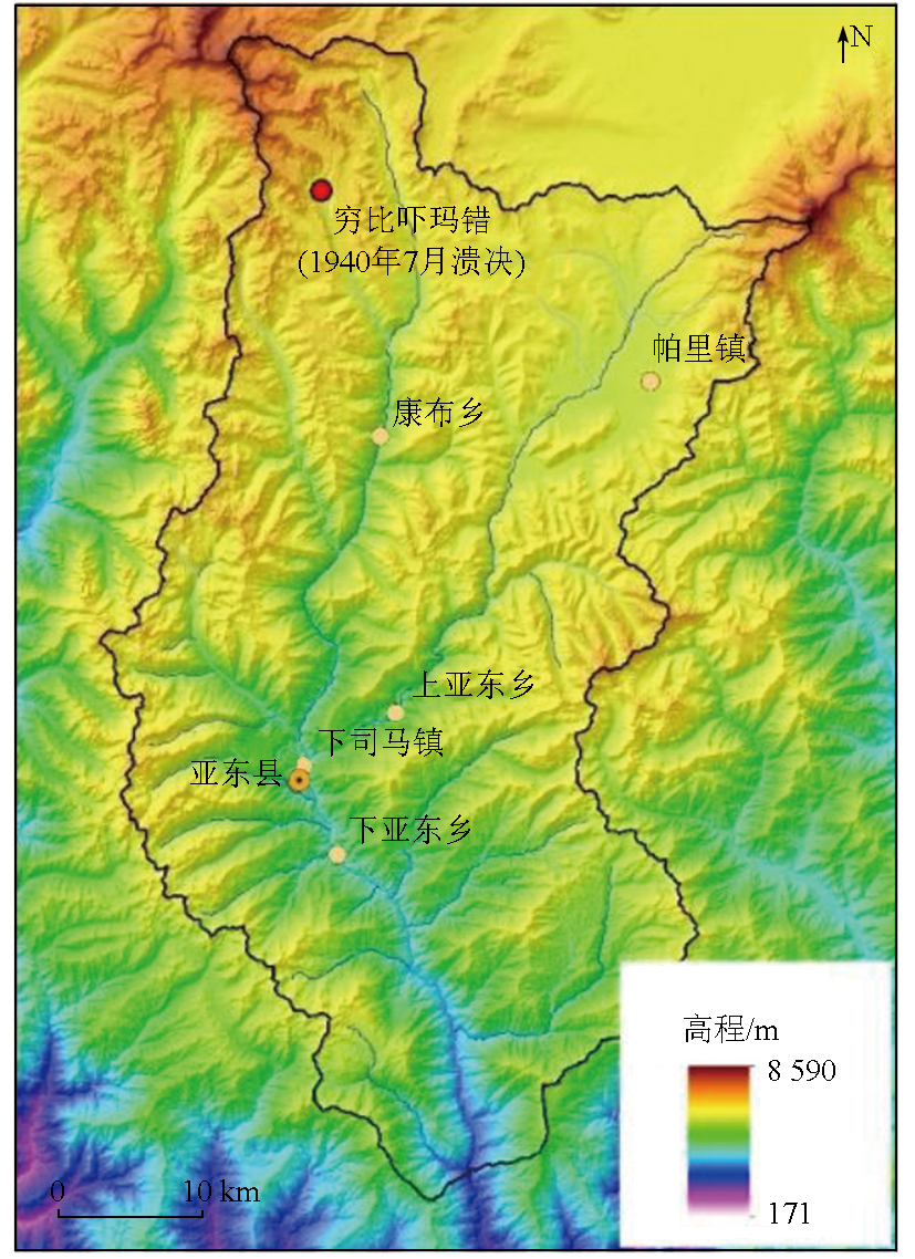
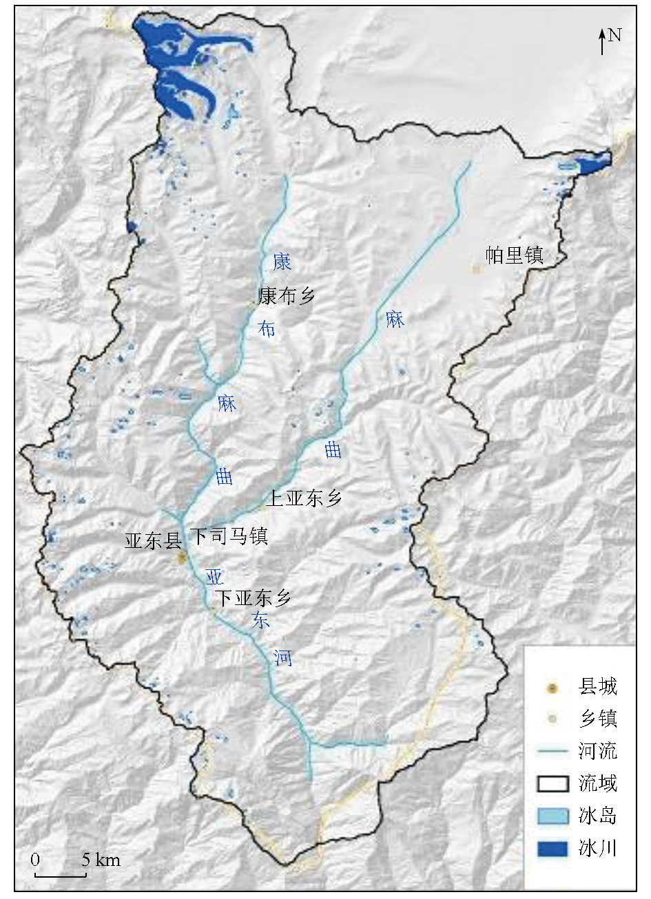
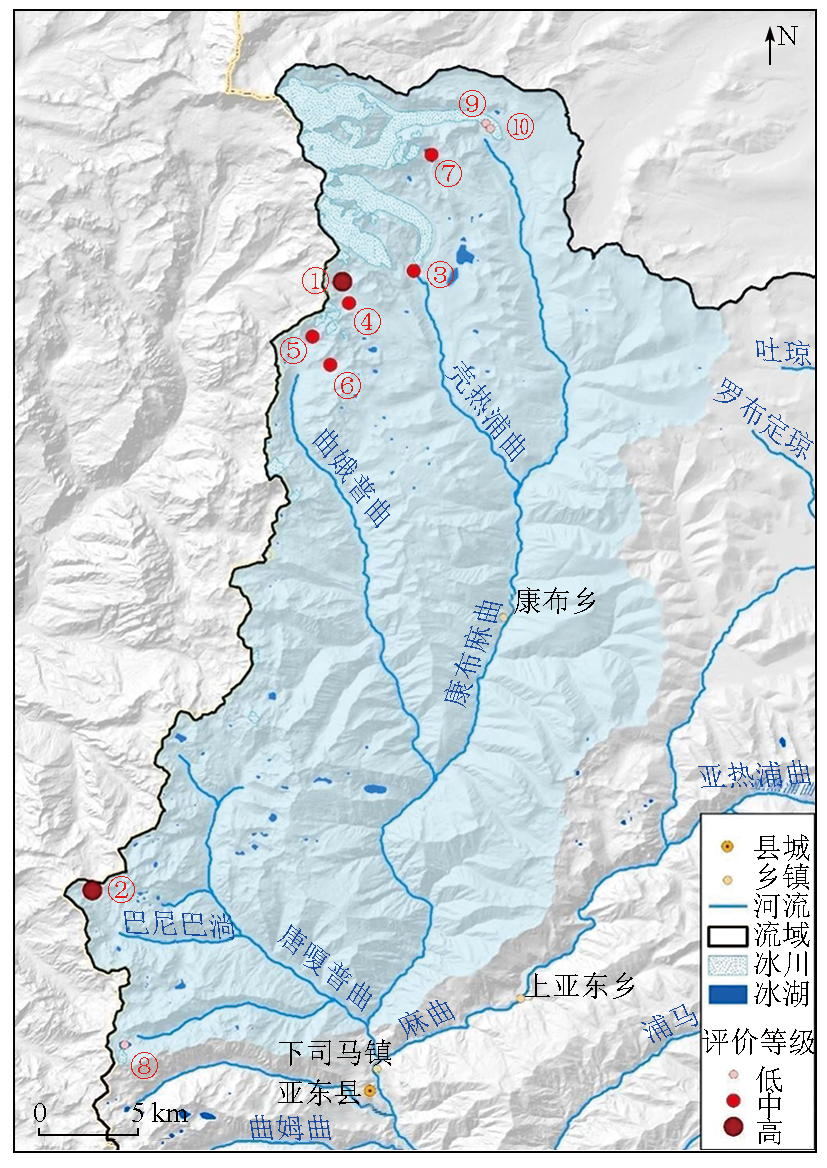
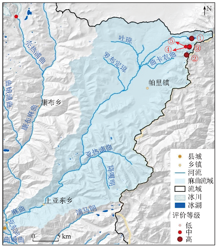
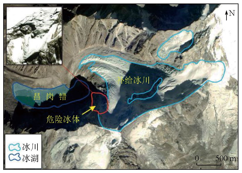
In recent years, global warming has caused significant glacier retreats in the Qinghai-Tibet Plateau, leading to the rapid expansion of glacial lakes and an increased threat of glacial lake outburst floods (GLOFs). The Yadong River basin, located in Shigatse, Tibet, hosts a large number of glacial lakes. In 1940, a GLOF from Qiongbixiama Co severely damaged Yadong County 40 km downstream, causing house collapse and infrastructure destruction. Therefore, assessing the hazards of potential GLOSs in the Yadong River basin is vital for protecting the safety of people’s lives and property. This study conducted a survey and assessment of potential GLOFs based on Gaofen satellite data and Landsat remote sensing images. It derived basic elements including glaciers, glacial lakes, and moraines through remote sensing image interpretation. The results show that the Yadong River basin develops 28 glaciers and 228 glacial lakes, covering total areas of 34.03 km2 and 7.79 km2, respectively. The past 30 years have seen slight retreats of glaciers and slight expansions of glacial lakes. Combined with the elements derived from remote sensing images, the analytic hierarchy process and fuzzy comprehensive assessment were employed to preliminarily assess the hazard of regional glacial lakes, delineating the distribution of potentially hazardous glacial lakes. The assessment results reveal 15 potentially hazardous glacial lakes in the Yadong River basin, including five highly hazardous, eight moderately hazardous, and two slightly hazardous glacial lakes. These lakes are primarily distributed in the northeastern and northwestern high mountain areas in the Yadong River basin.

Key wordsglacial lake outburst flood    remote sensing    hazard assessment    Yadong River basin
收稿日期: 2023-11-24      出版日期: 2025-05-09
ZTFLH:  TP79  
基金资助:中国地质调查局地质调查项目“青藏高原及周缘地区冰崩冰湖溃决灾害(链)遥感地质调查与评价”(DD20230448);国家重点研发计划项目“广域崩滑灾害隐患综合遥感识别与监测技术”(2021YFC3000402)
通讯作者: 涂杰楠(1982-),男,博士,正高级工程师,主要从事冰川型地质灾害遥感调查与评价。Email: tujienan@outlook.com
作者简介: 朱登新(1999-),男,硕士研究生,主要从事地质灾害遥感调查与评价。Email: 2417723749@qq.com
引用本文:   
朱登新, 涂杰楠, 孙海冰, 韩振傑, 童立强, 郭兆成, 余江宽, 阎书豪, 贺鹏, 朱俊杰. 基于多源卫星数据亚东河流域冰湖溃决灾害危险性分析[J]. 自然资源遥感, 2025, 37(2): 96-107.
ZHU Dengxin, TU Jienan, SUN Haibing, HAN Zhenjie, TONG Liqiang, GUO Zhaocheng, YU Jiangkuan, YAN Shuhao, HE Peng, ZHU Junjie. Hazard assessment of potential glacial lake outburst floods in the Yadong River basin based on multisource satellite data. Remote Sensing for Natural Resources, 2025, 37(2): 96-107.
链接本文:  
https://www.gtzyyg.com/CN/10.6046/zrzyyg.2023356      或      https://www.gtzyyg.com/CN/Y2025/V37/I2/96
Fig.1  亚东河流域地理位置示意图
序号 卫星 传感器 分辨率/m 时间 行列号或经纬度
1 Landsat5 TM传感器 30 19910921 139041
2 Landsat5 TM传感器 30 19911007 139041
3 Landsat5 TM传感器 30 19911108 139041
4 Landsat5 TM传感器 30 19920324 139041
5 Landsat5 TM传感器 30 19920416 139041
6 Landsat8 OLI传感器 15 20201123 139041
7 Landsat8 OLI传感器 15 20201225 139041
8 Landsat8 OLI传感器 15 20210211 139041
9 高分一号B星 PMS传感器 2 20210827 E89.0_N27.4
10 高分一号D星 PMS传感器 2 20210101 E89.1_N28.0
Tab.1  使用遥感数据具体信息
地貌和地质条件 定性/定量 有关属性 数据来源
冰湖类型 定性 冰湖成因类型 高分影像
冰湖后缘陡坎高度 定量 高差 DEM数据
冰湖与冰川距离 定量 距离 高分影像
补给冰川的冰舌坡度 定量 坡度 DEM数据
危险冰体的面积与冰湖面积的比例 定量 危险面积、面积比 高分影像
冰湖面积 定量 面积 高分影像
冰碛坝体坝顶较窄 定量 坝顶宽度 高分影像
冰碛垄坡度较陡 定量 平均坡度、最大坡度 DEM数据
冰湖扩张速率 定量 扩张速率 高分影像
补给冰川为悬冰川 定性 冰川形态类型 高分影像
冰湖与终碛垄和补给冰川的相对位置 定性 相对位置 高分影像
Tab.2  冰湖溃决灾害评价要素详细信息及来源
要素 X1 X2 X3 X4 X5 X6 X7 X8 X9 X10 X11
X1 1 1 1 2 2 2 3 5 5 7 7
X2 1 1 1 2 2 2 3 5 5 7 7
X3 1 1 1 2 2 2 3 5 5 7 7
X4 1/2 1/2 1/2 1 1 1 2 3 4 6 6
X5 1/2 1/2 1/2 1 1 1 2 3 4 6 6
X6 1/2 1/2 1/2 1 1 1 2 3 4 6 6
X7 1/3 1/3 1/3 1/2 1/2 1/2 1 3 3 5 5
X8 1/5 1/5 1/5 1/3 1/3 1/3 1/3 1 2 4 4
X9 1/5 1/5 1/5 1/4 1/4 1/4 1/3 1/2 1 3 3
X10 1/7 1/7 1/7 1/6 1/6 1/6 1/5 1/4 1/3 1 1
X11 1/7 1/7 1/7 1/6 1/6 1/6 1/5 1/4 1/3 1 1
Tab.3  冰湖溃决要素的判断矩阵
区间 I II III
ax≤(a+b)/2 1 4 - 1 4 s i n 2 π b - a x - 3 a + b 4 3 4 + 1 4 s i n 2 π b - a x - 3 a + b 4 0
(a+b)/2<xb 3 4 + 1 4 s i n 2 π b - a 3 a + b 4 - x 1 4 - 1 4 s i n 2 π b - a 3 a + b 4 - x 0
b<x≤(b+c)/2 0 1 4 - 1 4 s i n 2 π c - b x - 3 b + c 4 3 4 + 1 4 s i n 2 π c - b x - 3 b + c 4
(b+c)/2<xc 0 3 4 + 1 4 s i n 2 π c - b 3 b + c 4 - x 1 4 - 1 4 s i n 2 π c - b 3 b + c 4 - x
x>c 0 1 2 s i n c π 2 x 1 - 1 2 s i n c π 2 x
Tab.4  各区间值对应的隶属函数
Fig.2  亚东河流域及子流域分布
Fig.3  亚东河流域冰川冰湖分布
流域 年份
1991年 2021年 变化
数量/条 面积/
km2
数量/条 面积/
km2
数量变
化/条
面积变
化/km2
康布麻曲流域 25 32.446 20 30.516 -5 -1.93
麻曲流域 8 4.062 8 3.510 0 -0.55
合计 33 36.508 28 34.026 -5 -2.48
Tab.5  不同流域冰川分布情况
冰湖 1991年 2021年 变化
数量/个 面积/km2 数量/个 面积/km2 数量变化/个 面积/km2
康布麻曲流域 98 3.779 108 3.701 10 -0.078
麻曲流域 30 1.101 27 1.062 -3 -0.039
曲姆曲流域 11 0.718 13 0.836 2 0.118
浦马朗流域 10 0.705 13 0.724 3 0.019
洞朗曲流域 13 0.378 15 0.401 2 0.023
鲁林曲流域 5 0.255 11 0.433 6 0.178
加朗曲流域 6 0.158 10 0.180 4 0.022
恰尔塘曲流域 8 0.159 10 0.118 2 -0.041
曲达康曲流域 11 0.137 11 0.171 0 0.034
比吾塘曲流域 9 0.117 10 0.165 1 0.048
合计 201 7.507 228 7.791 27 0.284
Tab.6  按流域统计冰湖数据
序号 冰湖编码 面积/m2 经度/(°) 纬度/(°) 危险
等级
1 GL088889E27842N 10 668.90 88.889 6 27.842 5
2 GL088776E27566N 4 058.83 88.776 2 27.566 7
3 GL088921E27847N 42 114.90 88.921 9 27.847 4
4 GL088892E27832N 23 437.70 88.892 6 27.832 8
5 GL088875E27817N 36 026.00 88.875 9 27.817 6
6 GL088884E27804N 15 963.40 88.884 1 27.804 7
7 GL088930E27899N 155 118.00 88.930 0 27.899 9
8 GL088790E27496N 159 937.00 88.790 8 27.496 7
9 GL088954E27914N 17 982.50 88.954 5 27.914 2
10 GL088956E27911N 13 013.70 88.956 8 27.911 6
Tab.7  康布麻曲流域中冰湖信息
Fig.4  康布麻曲流域不同危险等级冰湖分布
序号 冰湖编码 面积/m2 经度/(°) 纬度/(°) 危险
等级
1 GL089230E27808N 562 194.00 89.230 5 27.808 8
2 GL089221E27780N 9 330.24 89.221 6 27.780 0
3 GL089227E27795N 10 876.20 89.227 4 27.795 4
4 GL089226E27794N 12 770.20 89.226 3 27.794 3
5 GL089220E27794N 35 529.60 89.220 1 27.794 5
Tab.8  麻曲流域冰湖信息
Fig.5  麻曲流域危险性冰湖分布
Fig.6  昌岗错及其补给冰川高分遥感影像
Fig.7  昌岗错实地踏勘照片
Fig.8  曲加-那嘎东水深变化分布模拟
Fig.9  曲加-那嘎东剖面水深分布模拟
Fig.10  亚东县县城及周边区域居民区水深分布模拟
Fig.11  亚东县县城及周边区域水深分布模拟
[1] Maurer J M, Schaefer J M, Rupper S, et al. Acceleration of ice loss across the Himalayas over the past 40 years[J]. Science Advances, 2019, 5(6): eaav7266.
[2] 余斌, 何元勋, 刘秧. 冰碛湖溃决易发性的定量评价[J]. 地球科学, 2022, 47(6):1999-2014.
Yu B, He Y X, Liu Y. Quantitative susceptibility assessment of breach of moraine-dammed lakes[J]. Earth Science, 2022, 47(6):1999-2014.
[3] 张太刚, 王伟财, 高坛光, 等. 亚洲高山区冰湖溃决洪水事件回顾[J]. 冰川冻土, 2021, 43(6): 1673-1692.
doi: 10.7522/j.issn.1000-0240.2021.0066
Zhang T G, Wang W C, Gao T G, et al. Glacial lake outburst floods on the high Mountain Asia: A review[J]. Journal of Glaciology and Geocryology, 2021, 43(6):1673-1692.
[4] 杨兴国, 曹志翔, 邢会歌, 等. 冰碛土滑坡—泥石流—堰塞湖灾害链发展过程机理与模拟技术研究构想[J]. 工程科学与技术, 2022, 54(3): 1-13.
Yang X G, Cao Z X, Xing H G, et al. Research framework of the program: Dynamic evolution mechanism and simulation of moraine landslide—debris flow—dammed lake disaster chain[J]. Advanced Engineering Sciences, 2022, 54(3):1-13.
[5] 王欣, 刘时银, 姚晓军, 等. 我国喜马拉雅山区冰湖遥感调查与编目[J]. 地理学报, 2010, 65(1):29-36.
Wang X, Liu S Y, Yao X J, et al. Glacier lake investigation and inventory in the Chinese Himalayas based on the remote sensing data[J]. Acta Geographica Sinica, 2010, 65(1):29-36.
doi: 10.11821/xb201001004
[6] 程尊兰, 朱平一, 宫怡文. 典型冰湖溃决型泥石流形成机制分析[J]. 山地学报, 2003, 21(6):716-720.
Cheng Z L, Zhu P Y, Gong Y W. Typical debris flow triggered by ice-lake break[J]. Journal of Mountain Research, 2003, 21(6):716-720.
[7] Zhang G Q, Yao T D, Xie H J, et al. An inventory of glacial lakes in the Third Pole region and their changes in response to global warming[J]. Global and Planetary Change, 2015, 131:148-157.
[8] Zheng G X, Allen S K, Bao A, et al. Increasing risk of glacial lake outburst floods from future Third Pole deglaciation[J]. Nature Climate Change, 2021, 11(5): 411-417.
[9] 王欣, 刘时银, 郭万钦, 等. 我国喜马拉雅山区冰碛湖溃决危险性评价[J]. 地理学报, 2009, 64(7): 782-790.
Wang X, Liu S Y, Guo W Q, et al. Hazard assessment of moraine-dammed lake outburst floods in the Himalayas,China[J]. Acta Geographica Sinica, 2009, 64(7):782-790.
[10] 车涛, 晋锐, 李新, 等. 近 20 a来西藏朋曲流域冰湖变化及潜在溃决冰湖分析[J]. 冰川冻土, 2004, 26(4):397-402.
Che T, Jin R, Li X, et al. Glacial lakes variation and the potentially dangerous glacial lakes in the Pumqu Basin of Tibet during the last two decades[J]. Journal of Glaciology and Geocryology, 2004, 26(4):397-402.
[11] 王跃, 安天浩. 典型冰湖溃决泥石流成因分析及危险性评价体系探讨[J]. 矿产勘查, 2018, 9(4):727-731.
Wang Y, An T H. Discussion on causes analysis and risk assessment system the typical glacial lake outburst debris flow[J]. Mineral Exploration, 2018, 9(4):727-731.
[12] 刘建康, 张佳佳, 高波, 等. 我国西藏地区冰湖溃决灾害综述[J]. 冰川冻土, 2019, 41(6): 1335-1347.
doi: 10.7522/j.issn.1000-0240.2019.0073
Liu J K, Zhang J J, Gao B, et al. An overview of glacial lake outburst flood in Tibet,China[J]. Journal of Glaciology and Geocryology, 2019, 41(6):1335-1347.
[13] 周路旭, 刘建康, 李元灵. 川藏交通廊道龙利空泽错冰碛湖溃决危险性评价[J]. 地理与地理信息科学, 2020, 36(6):32-39,47.
Zhou L X, Liu J K, Li Y L. Outburst risk assessment of Longlikongze Moraine Lake in Sichuan-Tibet traffic corridor[J]. Geography and Geo-Information Science, 2020, 36(6):32-39,47.
[14] 乐茂华, 唐川, 张丹丹, 等. 基于逻辑回归法的西藏地区冰湖溃决危险性预测模型[J]. 自然灾害学报, 2014, 23(5): 177-184.
Le M H, Tang C, Zhang D D, et al. Logistic regression model- based approach for predicting the hazard of glacial lake outburst in Tibet[J]. Journal of Natural Disasters, 2014, 23(5):177-184.
[15] Richardson S D, Reynolds J M. An overview of glacial hazards in the Himalayas[J]. Quaternary International, 2000, 65:31-47.
[16] 亚东县人民政府. 亚东县概况[EB/OL]. [2021-06-23] http://www.ydx.gov.cn/news-detail.thtml?cid=136260.
Yadong County People's Government. Overview of Yadong County[EB/OL]. [2021-06-23] http://www.ydx.gov.cn/news-detail.thtml?cid=136260.
[17] 童立强, 祁生文, 安国英, 等. 喜马拉雅山地区重大地质灾害遥感调查研究[M]. 北京: 科学出版社, 2013:116.
Tong L Q, Qi S W, An G Y, et al. Remote sensing investigation of major geological disasters in Himalayan region[M]. Beijing: Science Press, 2013:116.
[18] 刘时银, 姚晓军, 郭万钦, 等. 基于第二次冰川编目的中国冰川现状[J]. 地理学报, 2015, 70(1):3-16.
doi: 10.11821/dlxb201501001
Liu S Y, Yao X J, Guo W Q, et al. The contemporary glaciers in China based on the second Chinese glacier inventory[J]. Acta Geographica Sinica, 2015, 70(1):3-16.
doi: 10.11821/dlxb201501001
[19] 姚晓军, 刘时银, 韩磊, 等. 冰湖的界定与分类体系——面向冰湖编目和冰湖灾害研究[J]. 地理学报, 2017, 72(7):1173-1183.
doi: 10.11821/dlxb201707004
Yao X J, Liu S Y, Han L, et al. Definition and classification systems of glacial lake for inventory and hazards study[J]. Acta Geographica Sinica, 2017, 72(7):1173-1183.
doi: 10.11821/dlxb201707004
[20] 王世金, 汪宙峰. 冰湖溃决灾害综合风险评估与管控:以中国喜马拉雅山区为例[M]. 北京: 中国社会科学出版社, 2017: 91-95.
Wang S J, Wang Z F. Comprehensive risk assessment and control of glacial lake outburst disaster:A case study of Himalayan Mountain area in China[M]. Beijing: China Social Sciences Press, 2017: 91-95.
[21] 陈晓清, 崔鹏, 杨忠, 等. 近15 a喜玛拉雅山中段波曲流域冰川和冰湖变化[J]. 冰川冻土, 2005, 27(6):793-800.
Chen X Q, Cui P, Yang Z, et al. Change in glaciers and glacier lakes in Boiqu River basin,middle Himalayas during last 15 years[J]. Journal of Glaciology and Geocryology, 2005, 27(6):793-800.
[22] 范建容, 李炫, 游勇, 等. 川藏铁路然乌—通麦段冰湖溃决危险性模糊综合评价及应用[C]// “川藏铁路建设的挑战与对策”2016 学术交流会论文集.中国科学院水利部成都山地灾害与环境研究所, 2016.
Fan J R, Li X, You Y, et al. Fuzzy comprehensive assessment of glacier-lake outburst from Ranwu to Tongmai along Sichuan-Tibet railway[C]// "Challenges and Countermeasures of Sichuan-Tibet Railway Construction" Proceedings of 2016 Academic Exchange Conference.Institute of Mountain Hazards and Environment,Chinese Academy of Sciences, 2016.
[23] 崔志超, 王俊豪, 崔传峰, 等. 基于层次分析法和模糊数学相结合的甘肃东乡八丹沟泥石流易发性评价[J]. 中国地质灾害与防治学报, 2020, 31(1):44-50.
Cui Z C, Wang J H, Cui C F, et al. Evaluation of the susceptibility of debris flow in Badan Gully of Dongxiang County of Gansu based on AHP and fuzzy mathematics[J]. The Chinese Journal of Geological Hazard and Control, 2020, 31(1):44-50.
[1] 何晓军, 罗杰. 结合上下文与类别感知特征融合的高分遥感图像语义分割[J]. 自然资源遥感, 2025, 37(2): 1-10.
[2] 史俊波, 张杰, 侯娜, 张辉善, 丁晓平, 杜建军, 朱海洋. 川西可尔因稀有金属矿集区遥感地质找矿应用[J]. 自然资源遥感, 2025, 37(2): 117-127.
[3] 庞敏. 国产多源卫片图斑智能提取平台研究与应用[J]. 自然资源遥感, 2025, 37(2): 148-154.
[4] 张静, 胡晓佳, 王威, 陈东磊, 黄旭红, 杨俊泉. 张北地区自然资源及生态状况综合评价与分析[J]. 自然资源遥感, 2025, 37(2): 164-172.
[5] 谢宜嘉, 杨倍倍, 张镇, 陈佳, 王喆, 孟令奎. 2000—2022年北京市植被春季物候期变化特征分析[J]. 自然资源遥感, 2025, 37(2): 185-193.
[6] 聂诗音, 刘严松, 李会玲, 薛凯伦, 沈杜衡, 何博宇. 基于图谱耦合的高寒湿地土地类型识别与分类[J]. 自然资源遥感, 2025, 37(2): 204-211.
[7] 余姝辰, 邱罗, 贺秋华, 金小燕, 李嘉宝, 余德清. 基于多源遥感的洞庭湖洲滩时空演变研究[J]. 自然资源遥感, 2025, 37(2): 228-234.
[8] 刘翼遥, 吴太夏, 王树东, 鞠茂森. 耦合遥感与SWAT模型的岸边植被带消减面源污染效能研究[J]. 自然资源遥感, 2025, 37(2): 256-264.
[9] 谢国雪, 黄启厅, 杨绍锷, 梁永检, 覃泽林, 苏秋群. 星地协同下地块尺度柑橘黄龙病监测技术研究[J]. 自然资源遥感, 2025, 37(2): 30-38.
[10] 肖文菊, 杨颖频, 吴志峰. 多云多雨区耕地撂荒多源遥感协同监测[J]. 自然资源遥感, 2025, 37(2): 39-48.
[11] 奥勇, 汪雅, 王晓峰, 吴京盛, 张亦恒, 李雪娇. 2001—2020年间河南省郑州市生态环境质量时空变化及驱动因素分析[J]. 自然资源遥感, 2025, 37(1): 102-112.
[12] 陈佳雪, 肖东升, 陈虹宇. 一种边界引导与跨尺度信息交互网络用于遥感影像水体提取[J]. 自然资源遥感, 2025, 37(1): 15-23.
[13] 石海岗, 梁春利, 薛庆, 张恩, 章新益, 张建永, 张春雷, 程旭. 基于卫星遥感的秦山核电周边海域温度分布研究[J]. 自然资源遥感, 2025, 37(1): 152-160.
[14] 刘文慧, 李欣烨, 李晓燕. 基于综合遥感指数的松嫩平原西部草地退化及其对干旱的响应[J]. 自然资源遥感, 2025, 37(1): 232-242.
[15] 徐欣钰, 李小军, 盖钧飞, 李轶鲲. 结合NSCT变换和引导滤波的多光谱图像全色锐化算法[J]. 自然资源遥感, 2025, 37(1): 24-30.
Viewed
Full text


Abstract

Cited

  Shared   
  Discussed   
京ICP备05055290号-2
版权所有 © 2015 《自然资源遥感》编辑部
地址:北京学院路31号中国国土资源航空物探遥感中心 邮编:100083
电话:010-62060291/62060292 E-mail:zrzyyg@163.com
本系统由北京玛格泰克科技发展有限公司设计开发