Please wait a minute...
 
自然资源遥感  2025, Vol. 37 Issue (3): 17-22    DOI: 10.6046/gtzyyg.2023399
  矿山生态环境遥感监测专栏 本期目录 | 过刊浏览 | 高级检索 |
山东省矿山损毁土地和治理状况2021年度监测与分析
赵丽君1,2(), 刘欢1,2(), 张云1,2, 杨俊泉1,2, 王威1,2, 陈东磊1,2
1.中国地质调查局天津地质调查中心,天津 300170
2.中国地质调查局华北地质科技创新中心,天津 300170
Monitoring and analysis of new mining-destroyed land and land restoration and management in Shandong Province in 2021
ZHAO Lijun1,2(), LIU Huan1,2(), ZHANG Yun1,2, YANG Junquan1,2, WANG Wei1,2, CHEN Donglei1,2
1. Tianjin Centre of Geological Survey, China Geological Survey, Tianjin 300170, China
2. North China Center for Geoscience Innovation, China Geological Survey, Tianjin 300170, China
全文: PDF(2652 KB)   HTML  
输出: BibTeX | EndNote (RIS)      
摘要 

及时准确监测与分析矿山开发占地及恢复治理情况是矿山环境遥感调查与监测工作的主要任务。该文以高空间分辨率遥感数据为主要数据源,圈定了2021年山东省新增矿山损毁土地和恢复治理面积:新增矿山损毁土地面积558.07 hm2,另有基建修路损毁26.59 hm2、尾矿库工程治理77.03 hm2;新增恢复治理面积1 019.07 hm2,其中人工恢复治理975.29 hm2,自然恢复43.78 hm2。初步分析了山东省2021年新增矿山损毁土地和恢复治理土地等遥感工作情况及存在问题,并针对这些问题提出了对策建议。调查与监测结果可为山东省土地管理部门科学决策提供有力支撑。

服务
把本文推荐给朋友
加入引用管理器
E-mail Alert
RSS
作者相关文章
赵丽君
刘欢
张云
杨俊泉
王威
陈东磊
关键词 矿山损毁土地土地恢复治理遥感监测山东省    
Abstract

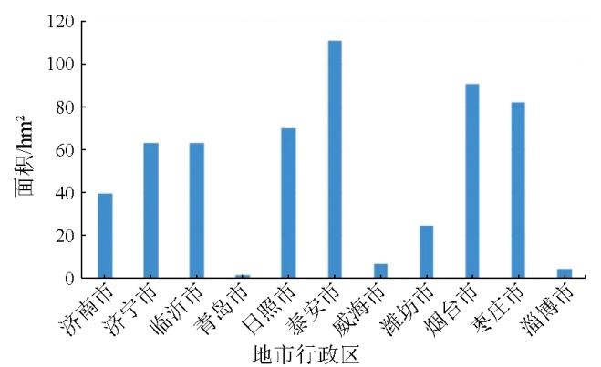
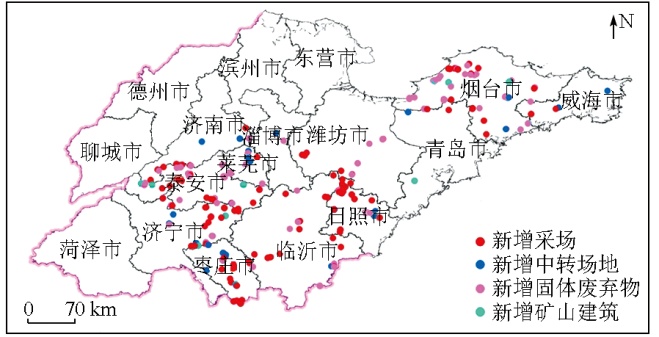
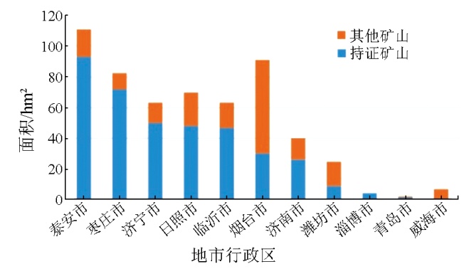
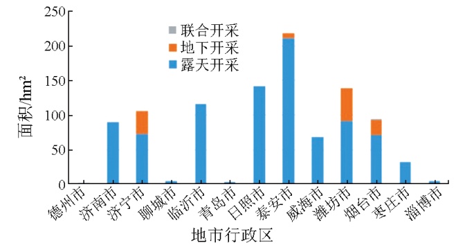
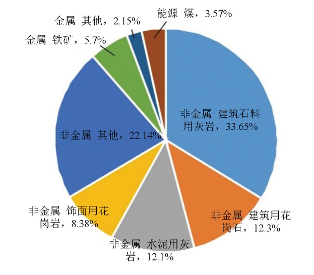
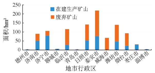
Timely and accurate monitoring and analysis of land for mine development and associated restoration and management is a principal task in remote sensing survey and monitoring of mine environments. Hence, using high-spatial-resolution remote sensing data as primary data source, this study delineated the new mining-destroyed land area (558.07 hm2) and land restoration and management area (1 019.07 hm2, including artificially restored 975.29 hm2 and naturally restored 43.78 hm2) in Shandong Province in 2021. Additionally, there were 26.59 hm2 of destroyed land due to infrastructure and road construction and 77.03 hm2 of tailings pond management. By preliminarily analyzing the remote sensing work concerning the new mining-destroyed land and land restoration and management in Shandong Province in 2021, this study proposed countermeasures and suggestions for existing problems. The investigation and monitoring results can effectively support the scientific decision-making of land management departments in Shandong Province.

Key wordsmining-destroyed land    land restoration and management    remote sensing monitoring    Shandong Province
收稿日期: 2023-08-28      出版日期: 2025-07-01
ZTFLH:  TP79  
基金资助:中国地质调查局项目“华北地区自然资源动态监测与风险评估”(DD20230101)
通讯作者: 刘欢(1983-),女,硕士,正高级工程师,主要从事地质矿产、遥感地质工作。Email: 17769266@qq.com
作者简介: 赵丽君(1986-),女,硕士,高级工程师,主要从事地质矿产、遥感地质工作。Email: 86orange@163.com
引用本文:   
赵丽君, 刘欢, 张云, 杨俊泉, 王威, 陈东磊. 山东省矿山损毁土地和治理状况2021年度监测与分析[J]. 自然资源遥感, 2025, 37(3): 17-22.
ZHAO Lijun, LIU Huan, ZHANG Yun, YANG Junquan, WANG Wei, CHEN Donglei. Monitoring and analysis of new mining-destroyed land and land restoration and management in Shandong Province in 2021. Remote Sensing for Natural Resources, 2025, 37(3): 17-22.
链接本文:  
https://www.gtzyyg.com/CN/10.6046/gtzyyg.2023399      或      https://www.gtzyyg.com/CN/Y2025/V37/I3/17
Fig.1  山东省2021年新增矿山损毁土地面积
Fig.2  2021年度研究区新增矿山损毁土地遥感监测图
Fig.3  山东省2021年各矿种新增矿山损毁土地面积占比
Fig.4  山东省2021年各市持证矿山和其他矿山新增损毁土地面积
地级行政区 工程恢复治理 自然恢复 连带恢复 合计
泰安市 219.11 0.04 219.15
日照市 135.16 6.37 141.53
潍坊市 139.65 139.65
临沂市 111.45 4.98 116.43
济宁市 105.38 105.38
烟台市 91.86 0.95 92.81
济南市 48.52 41.56 90.08
威海市 68.04 68.04
枣庄市 31.13 1.20 32.33
聊城市 5.05 5.05
淄博市 4.77 4.77
青岛市 1.61 1.23 2.83
德州市 1.01 1.01
合计 962.74 43.78 12.55 1 019.07
Tab.1  山东省新增矿山恢复治理面积统计
Fig.5  山东省2021年各市不同开采方式新增矿山环境恢复治理面积
Fig.6  山东省2021年不同矿种新增矿山环境恢复治理面积统计
Fig.7  山东省2021年各市不同开采状态矿山新增恢复治理统计
矿山 2018年 2019年 2020年 2021年
采场 596.23 415.91 258.79 343.04
中转场地 141.03 119.01 44.91 129.74
固体废弃物 226.21 152.59 22.16 79.50
矿山建筑 7.56 2.98 2.84 5.79
恢复治理 5 245.50 1 652.75 1 873.84 1 019.07
Tab.2  山东省2018—2021年矿山新增损毁和恢复治理统计表
[1] 杨金中, 许文佳, 姚维岭, 等. 全国采矿损毁土地分布与治理状况及存在问题[J]. 地学前缘, 2021, 28(4):83-89.
doi: 10.13745/j.esf.sf.2020.10.8
Yang J Z, Xu W J, Yao W L, et al. Land destroyed by mining in China:Damagedistribution,rehabilitation status and existing problems[J]. Earth Science Frontiers, 2021, 28(4):83-89.
[2] 杨金中, 秦绪文, 聂洪峰, 等. 全国重点矿区矿山遥感监测综合研究[J]. 中国地质调查, 2015, 2(4):24-30.
Yang J Z, Qin X W, Nie H F, et al. Comprehensive research on remote sensing monitoring of the national concentration zones of the important mine[J]. Geological Survey of China, 2015, 2(4):24-30.
[3] 杨金中, 聂洪峰, 荆青青. 初论全国矿山地质环境现状与存在问题[J]. 国土资源遥感, 2017, 29(2):1-7.doi:10.6046/gtzyyg.2017.02.01.
Yang J Z, Nie H F, Jing Q Q. Preliminary analysis of mine geo-environment status and existing problems in China[J]. Remote Sen-sing for Natural Resources, 2017, 29(2):1-7.doi:10.6046/gtzyyg.2017.02.01.
[4] 柴永昌. 山东省几种优势非金属矿产的开发利用现状及其发展前景[J]. 山东地质, 1999, 15(4):50-55.
Chai Y C. Present development and utilization of nonmetallic mineral resources and their developing future in Shandong[J]. Geology of Shandong, 1999, 15(4):50-55.
[5] 郑雄伟, 彭孛, 尚坤. 基于国产卫星的遥感地质解译能力评估[J]. 自然资源遥感, 2021(3):1-10.doi:10.6046/zrzyyg.2020357.
Zheng X W, Peng B, Shang K. Assessment of the interpretation ability of domestic satellites in geological remote sensing[J]. Remote Sensing for Natural Resources, 2021(3):1-10.doi:10.6046/zrzyyg.2020357.
[6] 孔卓, 杨海涛, 郑逢杰, 等. 高光谱遥感图像大气校正研究进展[J]. 自然资源遥感, 2022, 34(4):1-10.doi:10.6046/zrzyyg.2021371.
Kong Z, Yang H T, Zheng F J, et al. Research advances in atmospheric correction of hyperspectral remote sensing images[J]. Remote Sensing for Natural Resources, 2022, 34(4):1-10.doi:10.6046/zrzyyg.2021371.
[7] 刘欢, 张云, 黄旭红, 等. 遥感技术在内蒙古自治区中西部重点矿区开采监测中的应用[J]. 华北地质, 2021, 44(4):55-60.
Liu H, Zhang Y, Huang X H, et al. Application of remote sensing technology in mining monitoring in midwest major mining area of Inner Mongolia[J]. North China Geology, 2021, 44(4):55-60.
[8] 梁晖, 杨士道. 遥感技术在蓟县北部矿山开采动态监测中的应用[J]. 地质调查与研究, 2005, 28(3):180-186.
Liang H, Yang S D. Application of remote sensing in the dynamic inspection of mining in northern Jixian[J]. Geological Survey and Research, 2005, 28(3):180-186.
[9] 马霭乃. 遥感目视解译的基本理论与方法[J]. 遥感信息, 1987, 2(3):26-29.
Ma A N. Basic theory and method of remote sensing visual interpretation[J]. Remote Sensing Information, 1987, 2(3):26-29.
[10] 张仙, 李伟, 陈理, 等. 露天开采矿区要素遥感提取研究进展及展望[J]. 自然资源遥感, 2023, 35(2):25-33.doi:10.6046/zrzyyg.2022141.
Zhang X, Li W, Chen L, et al. Research progress and prospect of remote sensing-based feature extraction of opencast mining areas[J]. Remote Sensing for Natural Resources, 2023, 35(2):25-33.doi:10.6046/zrzyyg.2022141.
[11] 黄登冕, 张聪, 姚晓军, 等. 矿山环境遥感监测研究进展[J]. 遥感技术与应用, 2022, 37(5):1043-1055.
doi: 10.11873/j.issn.1004-0323.2022.5.1043
Huang D M, Zhang C, Yao X J, et al. Research progress of mine environment remote sensing monitoring[J]. Remote Sensing Technology and Application, 2022, 37(5):1043-1055.
[12] 王建华, 李阳, 梁树能, 等. 基于高光谱卫星数据的土地沙化识别及提取研究[J]. 华北地质, 2022(4):60-67.
doi: 10.19948/j.12-1471/P.2022.04.08
Wang J H, Li Y, Liang S N, et al. The study of land desertification recognition and extraction based on hyperspectral satellite data[J]. North China Geology, 2022(4):60-67.
[13] 高俊华, 邹联学, 龙欢, 等. 基于遥感动态监测的吉林省矿山地质环境及生态修复变化特征分析[J]. 自然资源遥感, 2022, 34(3):240-248.doi:10.6046/zrzyyg.2021278.
Gao J H, Zou L X, Long H, et al. Analysis on characteristics of mine geological environment and ecological restoration changes in Jilin Province based on dynamic remote sensing monitoring[J]. Remote Sensing for Natural Resources, 2022, 34(3):240-248.doi:10.6046/zrzyyg.2021278.
[14] 唐静秋. 浅析遥感信息技术在自然资源监测监管中的应用[J]. 测绘与空间地理信息, 2022, 45(10):38-40.
Tang J Q. Exploration and application of remote sensing information technology in natural resources monitoring and supervision[J]. Geomatics & Spatial Information Technology, 2022, 45(10):38-40.
[15] 祁帅, 乔文光, 张勇. 遥感技术在内蒙古绿色矿山地质环境动态监测中的应用[J]. 测绘通报, 2021(s1):79-82.
Qi S, Qiao W G, Zhang Y. Application of remote sensing in green mine environment monitoring in the Inner Mongolia Autonomous Region[J]. Bulletin of Surveying and Mapping, 2021(s1):79-82.
[16] 中华人民共和国国土资源部. DZ/T 0266—2014 矿产资源开发遥感监测技术规范[S]. 北京: 中国标准出版社, 2014.
Ministry of Land and Resurces of the People’s Republic of China. DZ/T 0266—2014 Regulation on remote sensing monitoring of mining exploration[S]. Beijing: Standards Press of China, 2014.
[17] 修晓龙. 山西省矿山开发新增损毁土地年度监测与分析[J]. 中国矿业, 2022, 31(2):59-64.
Xiu X L. Annual monitoring and analysis of newly damaged land in mine development in Shanxi Province[J]. China Mining Magazine, 2022, 31(2):59-64.
[1] 刘欢, 刘晓雪, 张云, 杨俊泉, 曾辉. 河南省2021年新增矿山损毁和恢复治理遥感监测状况及存在问题[J]. 自然资源遥感, 2025, 37(3): 23-31.
[2] 李婷, 叶丽娟, 杨俊泉, 张静, 张云, 刘欢. 内蒙古中西部矿山地质环境遥感调查[J]. 自然资源遥感, 2025, 37(3): 45-53.
[3] 石海岗, 梁春利, 薛庆, 张恩, 章新益, 张建永, 张春雷, 程旭. 基于卫星遥感的秦山核电周边海域温度分布研究[J]. 自然资源遥感, 2025, 37(1): 152-160.
[4] 康辉, 窦文章, 韩灵怡, 丁梓越, 吴亮廷, 侯璐. 基于DeepLabv3+模型的地表水体快速遥感监测[J]. 自然资源遥感, 2024, 36(4): 117-123.
[5] 叶丽娟, 段霄龙, 李婷, 张静, 张云, 陈东磊. 河北省采矿损毁土地分布及治理状况分析[J]. 自然资源遥感, 2024, 36(4): 75-81.
[6] 孙禧勇, 刘稼丰, 范景辉, 张文凯, 石利娟, 邱玉宝, 朱发容. 积雪遥感监测产品研究与应用进展[J]. 自然资源遥感, 2024, 36(3): 13-27.
[7] 和海霞, 李博. 青海大通“8·18”山洪灾害特征及风险分析[J]. 自然资源遥感, 2024, 36(2): 135-141.
[8] 邢宇, 王静雅, 杨金中, 陈栋, 杜晓敏, 郭靖凯, 宋丽聪. 全国废弃露天矿山采矿用地分布状况与存在问题[J]. 自然资源遥感, 2024, 36(2): 21-26.
[9] 马晓雪, 焦润成, 曹颖, 南赟, 王晟宇, 郭学飞, 赵丹凝, 闫驰, 倪璇. 重大工程建设中地质灾害综合遥感监测技术方法应用——以北京2022冬奥会延庆赛区为例[J]. 自然资源遥感, 2024, 36(2): 248-256.
[10] 周小迦. 丘陵地带耕地撂荒遥感监测应用研究[J]. 自然资源遥感, 2024, 36(1): 235-241.
[11] 于航, 安娜, 汪洁, 邢宇, 许文佳, 步凡, 王晓红, 杨金中. 黔西南采煤塌陷区高分遥感动态监测——以六盘水市煤矿采空塌陷区为例[J]. 自然资源遥感, 2023, 35(3): 310-318.
[12] 李星佑, 张飞, 王筝. 土壤盐渍化遥感监测模型构建方法现状与发展趋势[J]. 自然资源遥感, 2022, 34(4): 11-21.
[13] 王娟, 王志红, 张建国, 初娜, 李斯, 尹展. 河南省国家级自然保护区人类活动遥感监测及其影响强度评价[J]. 自然资源遥感, 2022, 34(4): 235-242.
[14] 辛荣芳, 李宗仁, 张焜, 张兴, 黄丽, 刘宝山. 青海省湟水流域地质灾害动态变化遥感监测[J]. 自然资源遥感, 2022, 34(4): 254-261.
[15] 董双发, 范晓, 石海岗, 许莉萍, 章新益. 基于Landsat8和无人机的福清核电温排水分布研究[J]. 自然资源遥感, 2022, 34(3): 112-120.
Viewed
Full text


Abstract

Cited

  Shared   
  Discussed   
京ICP备05055290号-2
版权所有 © 2015 《自然资源遥感》编辑部
地址:北京学院路31号中国国土资源航空物探遥感中心 邮编:100083
电话:010-62060291/62060292 E-mail:zrzyyg@163.com
本系统由北京玛格泰克科技发展有限公司设计开发