|
|
 |
|

|
|
|
Assessment of forest damage due to ice-snow disaster based on the method of threshold ratio:A case study of Hunan Province |
Xuecheng WANG1,2, Fei YANG1( ), Xing GAO1, Yinghui ZHANG1,2 ), Xing GAO1, Yinghui ZHANG1,2 |
1. Institute of Geographic Sciences and Natural Resources Research, CAS, State Key Laboratory of Resources and Environmental Information System, Beijing 100101, China
2. University of Chinese Academy of Sciences, Beijing 100049, China |
|
|
|
|
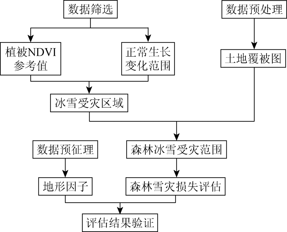
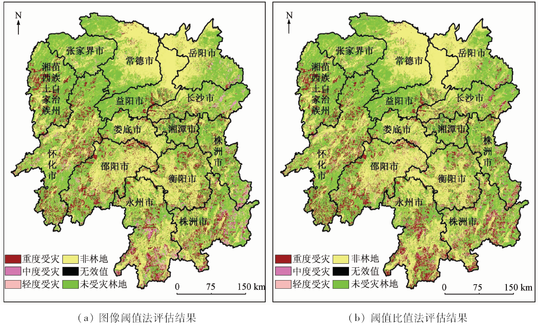
Abstract Ice-snow disasters are one of the main disruptions to forest ecological systems, causing the loss of forest structure and degeneration of ecological system's functions. Rapid and accurate assessment of forest resource loss has an important significance for starting the process post-disaster recovery and forest ecosystem management. Using MODIS Normalized Difference Vegetation Index (NDVI) images during 2001—2007, the authors extract pre-disaster reference value of plant NDVI and growth change threshold. In combination with post-disaster NDVI images, the range of Hunan forest ice-snow disaster is extracted by pre-disaster reference value and growth change threshold in 2008. The method of threshold ratio is proposed on the basis of method of image threshold, which is used to assess the loss of forest resources within the region of forest ice-snow disaster. A comparison with the method of image threshold shows that the assessing results from the method of threshold ratio are more close to the manual survey results, and its standard error is only 0.95, which is less than 1/3 of that of the image threshold method. The assessing results show that forest resources of the whole province have suffered serious losses: severe damaged rate, moderate damaged rate and mild damaged rate are 53.69%, 27.50% and 18.81%, respectively. What’s more, the analysis combined with topographic factors shows that forests in high altitudes are more severely affected than in low altitudes, and forests located in shady aspect are especially more severely affected.
|
| Keywords
method of threshold ratio
forest
ice-snow disaster
Hunan Province
|
|
|
|
Corresponding Authors:
Fei YANG
E-mail: yangfei@lreis.ac.cn
|
|
Issue Date: 10 September 2018
|
|
|
| [1] |
姚峰峰, 张时煌, 杨医 , 等. 冰冻雨雪灾害对江西林业影响的评估技术探讨[J]. 自然资源学报, 2009,24(9):1657-1666.
doi: 10.11849/zrzyxb.2009.09.015
url: http://www.cnki.com.cn/Article/CJFDTotal-ZRZX200909015.htm
|
| [1] |
Yao F F, Zhang S H, Yang Y , et al. Evaluating the impact of freezing rain and snow disaster on forestry in Jiangxi[J]. Journal of Natural Resources, 2009,24(9):1657-1666.
|
| [2] |
徐雅雯, 吴可可, 朱丽蓉 , 等. 中国南方雨雪冰冻灾害受损森林植被研究进展[J]. 生态环境学报, 2010,19(6):1485-1494.
url: 年度引用
|
| [2] |
Xu Y W, Wu K K, Zhu L R , et al. A review of freezing rain and snow impacts on forests in southern China[J]. Ecology and Environmental Sciences, 2010,19(6):1485-1494.
|
| [3] |
中国林业编辑部.林业系统全面开展冰雪灾害灾后重建[J].中国林业, 2008(4):1.
url: 年度引用
|
| [3] |
Editorial Department of Chinese forestry.Comprehensive developing reconstruction after ice-snow damage in forestry system[J].Forestry of China, 2008(4):1.
|
| [4] |
Hargrove W W Jr, Spruce J, Gasser G , et al. Toward a national early warning system for forest disturbances using remotely sensed canopy phenology[J]. Photogrammetric Engineering & Remote Sensing, 2009,75(10):1150-1156.
|
| [5] |
Petty J A, Worrell R . Stability of coniferous tree stems in relation to damage by snow[J]. Forestry: Institute of Foresters of Great Britain, 1981,54(2):115-128.
doi: 10.1093/forestry/54.2.115
url: http://europepmc.org/abstract/AGR/IND81119469
|
| [6] |
曹坤芳, 常杰 . 突发气象灾害的生态效应:2008年中国南方特大冰雪灾害对森林生态系统的破坏[J]. 植物生态学报, 2010,34(2):123-124.
doi: 10.3773/j.issn.1005-264x.2010.02.002
url: 年度引用
|
| [6] |
Cao K F, Chang J . The ecological effects of an unusual climatic disaster:The destruction to forest ecosystems by the extremely heavy glaze and snow storms occurred in early 2008 in southern China[J]. Chinese Journal of Plant Ecology, 2010,34(2):123-124.
|
| [7] |
何茜, 李吉跃, 陈晓阳 , 等. 2008年初特大冰雪灾害对粤北地区杉木人工林树木损害的类型及程度[J]. 植物生态学报, 2010,34(2):195-203.
doi: 10.3773/j.issn.1005-264x.2010.02.011
url: 年度引用
|
| [7] |
He Q, Li J Y, Chen X Y , et al. Types and extent of damage to Cunninghamia lanceolata plantations due to unusually heavy snow and ice in southern China[J]. Chinese Journal of Plant Ecology, 2010,34(2):195-203.
|
| [8] |
Isaacs R E, Stueve K M, Lafon C W , et al.Ice storms generate spatially heterogeneous damage patterns at the watershed scale in forested landscapes[J].Ecosphere, 2014, 5(11):art141.
doi: 10.1890/ES14-00234.1
url: http://doi.wiley.com/10.1890/ES14-00234.1
|
| [9] |
Millward A A, Kraft C E . Physical influences of landscape on a large-extent ecological disturbance:The northeastern North American ice storm of 1998[J]. Landscape Ecology, 2004,19(1):99-111.
doi: 10.1023/B:LAND.0000018369.41798.2f
url: http://link.springer.com/10.1023/B:LAND.0000018369.41798.2f
|
| [10] |
Olthof I, King D J, Lautenschlager R A . Mapping deciduous forest ice storm damage using Landsat and environmental data[J]. Remote Sensing of Environment, 2004,89(4):484-496.
doi: 10.1016/j.rse.2003.11.010
url: http://linkinghub.elsevier.com/retrieve/pii/S0034425703003420
|
| [11] |
郭晓宁, 裴惠娟, 王金平 , 等. 国际遥感技术在自然灾害领域中的发展态势分析[J]. 中国农学通报, 2016,32(6):124-131.
url: 年度引用
|
| [11] |
Guo X N, Pei H J, Wang J P , et al. Development status of international remote sensing in natural disaster research[J]. Chinese Agricultural Science Bulletin, 2016,32(6):124-131.
|
| [12] |
张振德, 何宇华 . 遥感技术在长江三峡库区大型地质灾害调查中的应用[J]. 国土资源遥感, 2003,15(2):11-14,16.doi: 10.6046/gtzyyg.2003.02.03.
doi: 10.3969/j.issn.1001-070X.2003.02.003
url: http://d.wanfangdata.com.cn/Periodical/gtzyyg200302003
|
| [12] |
Zhang Z D, He Y H . The application of remote sensing technology to the investigation of large-scale geological hazards in the Three Gorges Reservoir Area of the Yangtze River[J]. Remote Sensing for Land and Resources, 2003,15(2):11-14,16.doi: 10.6046/gtzyyg.2003.02.03.
|
| [13] |
莫伟华, 王君华, 钟仕全 , 等. 基于MODIS的冰雪遥感灾害监测与评估技术[J]. 林业科学, 2009,45(10):88-93.
doi: 10.3321/j.issn:1001-7488.2009.10.015
url: http://d.wanfangdata.com.cn/Periodical/lykx200910015
|
| [13] |
Mo W H, Wang J H, Zhong S Q , et al. Techniques for monitoring and evaluating the snow and ice disaster based on MODIS model[J]. Scientia Silvae Sinicae, 2009,45(10):88-93.
|
| [14] |
潘况一 . 基于多时相遥感影像的森林植被灾害损失与恢复评估——以2008年初广东省雪灾为例[D]. 北京:北京大学, 2011.
|
| [14] |
Pan K Y . Evaluation on Disaster Losses and Recovery of Forest Vegetation Based on Multi-Temporal Remote Sensing Images:A Case Study on Snowstorm in Guangdong in Early 2008[D]. Beijing:Peking University, 2011.
|
| [15] |
杨勇 . 基于MODIS数据南方五省植被冷冻灾害遥感评估与研究[D]. 广州:中国科学院广州地球化学研究所, 2009.
|
| [15] |
Yang Y . Assessment and Study on Vegetation Damage from Cold Disaster in Five Provinces of Southern China using MODIS Data[D].Guangzhou:Guangzhou Institute of Geochemistr, Chinese Academy of Sciences, 2009.
|
| [16] |
管远保 . 浅谈冰冻灾害对湖南森林资源的影响[J]. 湖南林业科技, 2008,35(4):80-81.
doi: 10.3969/j.issn.1003-5710.2008.04.029
url: http://d.wanfangdata.com.cn/Periodical/hunlykj200804029
|
| [16] |
Guan Y B . The effects on forest resource of Hunan Province of effects on rain and snow frozen disaster[J]. Hunan Forestry Science & Technology, 2008,35(4):80-81.
|
| [17] |
Holben B N . Characteristics of maximum-value composite images from temporal AVHRR data[J]. International Journal of Remote Sensing, 1986,7(11):1417-1434.
doi: 10.1080/01431168608948945
url: http://www.tandfonline.com/doi/abs/10.1080/01431168608948945
|
| [18] |
侯光雷, 张洪岩, 郭聃 , 等. 长白山区植被生长季NDVI时空变化及其对气候因子敏感性[J]. 地理科学进展, 2012,31(3):285-292.
doi: 10.11820/dlkxjz.2012.03.003
url: http://d.wanfangdata.com.cn/Periodical_dlkxjz201203003.aspx
|
| [18] |
Hou G L, Zhang H Y, Guo D , et al. Spatial-temporal Variation of NDVI in the Growing Season and its Sensitivity to Climatic Factors in Changbai Mountains[J]. Progress in Geography, 2012,31(3):285-292.
|
| [19] |
吴健生, 陈莎, 彭建 . 基于图像阈值法的森林雪灾损失遥感估测——以云南省为例[J]. 地理科学进展, 2013,32(6):913-923.
doi: 10.11820/dlkxjz.2013.06.008
url: http://d.wanfangdata.com.cn/Periodical/dlkxjz201306008
|
| [19] |
Wu J S, Chen S, Peng J . Assessment of forest damage due to ice storm using image thresholding techniques:A case study of Yunnan Province[J]. Progress in Geography, 2013,32(6):913-923.
|
| [20] |
Spruce J P, Sader S, Ryan R E , et al. Assessment of MODIS NDVI time series data products for detecting forest defoliation by gypsy moth outbreaks[J]. Remote Sensing of Environment, 2011,115(2):427-437.
doi: 10.1016/j.rse.2010.09.013
url: http://linkinghub.elsevier.com/retrieve/pii/S0034425710002865
|
| [21] |
道县林业局冰雪灾害调查组. 道县雨雪冰冻灾害森林资源损失调查评估报告[R]. 永州:道县林业局, 2008.
|
| [21] |
Ice-Snow Disaster Investigation Team, Daoxian County Forestry Bureau . Assessment Report on the Loss of Forest Resources in the Ice-Snow Disaster in Daoxian County[R]. Yongzhou:Daoxian County, 2008.
|
| [22] |
新田县林业局冰雪灾害调查组. 新田县雨雪冰冻灾害森林资源损失调查评估报告[R]. 永州:新田县林业局, 2008.
|
| [22] |
Ice-Snow Disaster Investigation Team, Xintian County Forestry Bureau . Assessment Report on the Loss of Forest Resources in the Ice-Snow Disaster in Xintian County[R]. Yongzhou:Xintian County, 2008.
|
| [23] |
江永县林业局冰雪灾害调查组. 江永县雨雪冰冻灾害森林资源损失调查评估报告[R]. 永州:江永县林业局, 2008.
|
| [23] |
Ice-snow disaster investigation team, Jiangyong County Forestry Bureau . Assessment report on the loss of forest resources in the ice-snow disaster in Jiangyong County[R]. Yongzhou:Jiangyong County, 2008.
|
| [24] |
朱鸿伟 . 森林生态系统的抗冰冻灾害能力研究[D]. 株洲:中南林业科技大学, 2011.
|
| [24] |
Zhu H W . The Research of the Anti Freeze Disaster Ability of Forest Ecosystem[D]. Zhuzhou:Central South University of Forestry and Technology, 2011.
|
| [25] |
李秀芬, 朱教君, 王庆礼 , 等. 森林的风/雪灾害研究综述[J]. 生态学报, 2005,25(1):148-157.
doi: 10.3321/j.issn:1000-0933.2005.01.024
url: http://d.wanfangdata.com.cn/Periodical/stxb200501024
|
| [25] |
Li X F, Zhu J J, Wang Q L , et al. Forest damage induced by wind/snow: a review[J]. Acta Ecologica Sinica, 2005,25(1):148-157.
|
| [26] |
周席华, 徐永杰, 罗治建 , 等. 湖北三峡库区退耕还林区柑橘低温冻害规律调查[J]. 林业科学, 2008,44(11):145-151.
doi: 10.3321/j.issn:1001-7488.2008.11.027
url: http://d.wanfangdata.com.cn/Periodical/lykx200811027
|
| [26] |
Zhou X H, Xu Y J, Luo Z J , et al. Characteristics of citrus freeze injury in the newly-reclaimed forest from formland of three gorges area in Hubei Province[J]. Scientia Silvae Sinicae, 2008,44(11):145-151.
|
| [27] |
杨曾奖, 徐大平, 曾杰 , 等. 南方大果紫檀等珍贵树种寒害调查[J]. 林业科学, 2008,44(11):123-127.
doi: 10.11707/j.1001-7488.20081123
url: 年度引用
|
| [27] |
Yang Z J, Xu D P, Zeng J , et al. A survey of freezing harm of precious trees in South China[J]. Scientia Silvae Sinicae, 2008,44(11):123-127.
|
|
Viewed |
|
|
|
Full text
|
|
|
|
|
Abstract
|
|
|
|
|
Cited |
|
|
|
|
| |
Shared |
|
|
|
|
| |
Discussed |
|
|
|
|
 2018,
Vol. 30
2018,
Vol. 30