|
|
 |
|

|
|
|
Generation of daily cloudless snow cover product in the past 15 years in Xinjiang and accuracy validation |
Xiaogang HOU1( ), Zhaojun ZHENG2(), Shuai LI3, Xuehua CHEN4, Yu CUI3 ), Zhaojun ZHENG2(), Shuai LI3, Xuehua CHEN4, Yu CUI3 |
1. Institute of Network Technology, Beijing University of Posts and Telecommunications, Beijing 100876, China
2. National Satellite Meteorological Center, China Meteorological Administration, Beijing 100081, China
3. Insitute of Desert Meteorology, China Meteorological Administration, Urumqi 830002, China
4. Xinjiang Academy of Surveying and Mapping, Urumqi 830002, China |
|
|
|
|
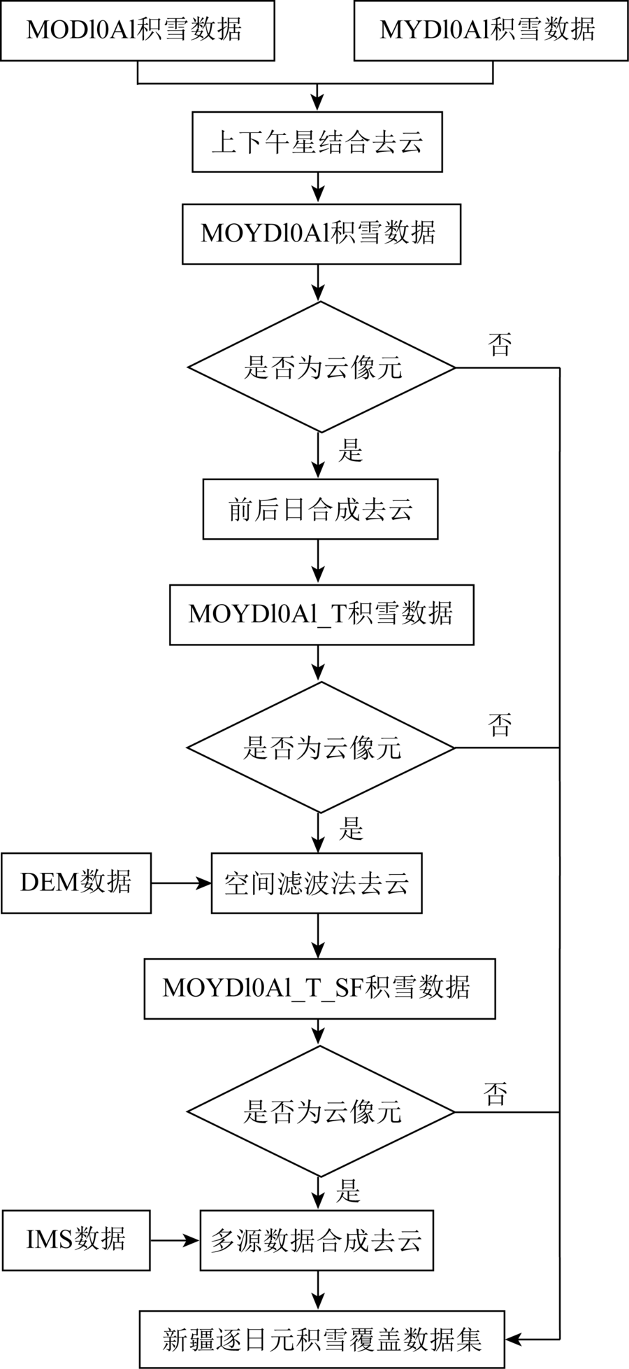
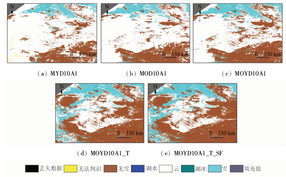
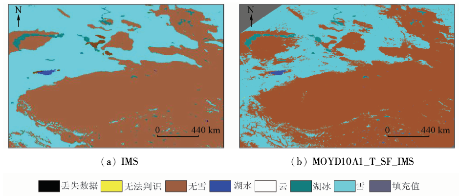
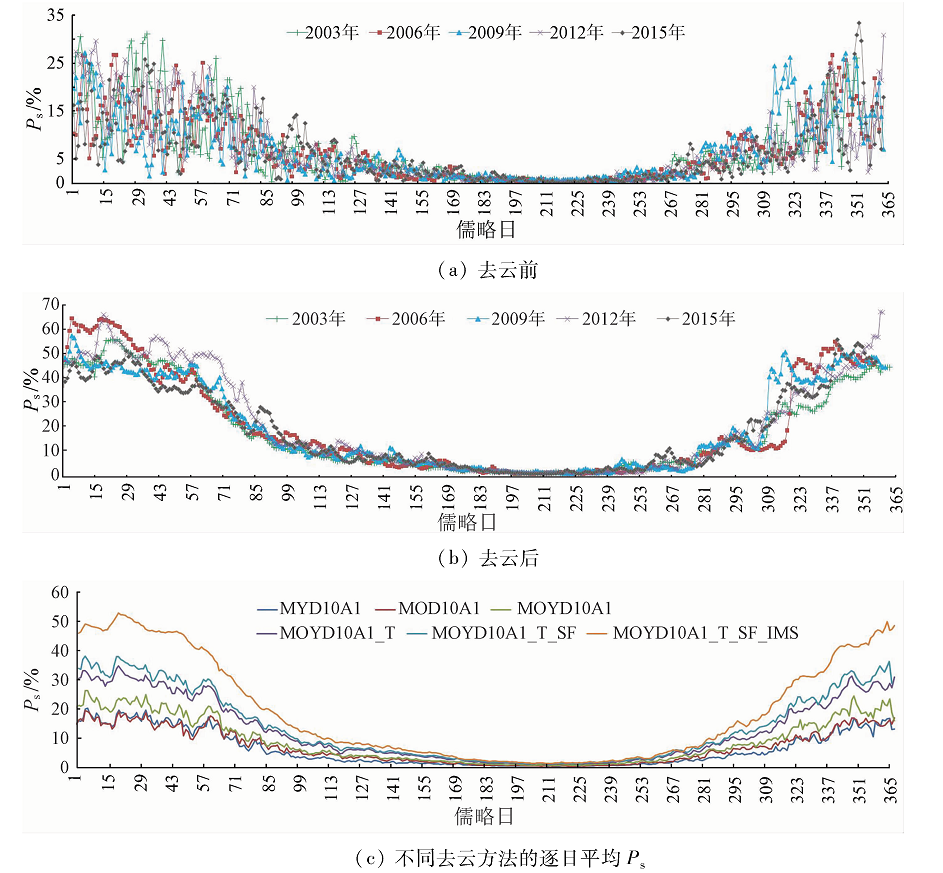
Abstract MODIS snow product data constitute one of the most common data in the real-time monitoring and the research on snow cover; nevertheless, the cloud is the biggest factor affecting the application of MODIS snow cover products (MOD10A1 and MYD10A1) to real-time monitoring and researching daily snow cover in Xinjiang region. By introducing such data as the interactive multi-sensor snow ice mapping system (IMS) data and the meteorological station observation data and combining the existent cloud removal methods based on temporal filter method, spatial filter method and multi-sensor data fusion method, the authors established a new cloud removal method based on multi-source remote sensing data, with which the 15-year-long daily snow cover product in clear air of the study area from 2002 to 2016 was generated. In addition, the accuracy of the cloud removed product was evaluated with field experiment data. The results show that the overall monitoring accuracy of the new product after cloud removal reaches 90.61% in the study area, which is close to the overall monitoring accuracy (93.3%) of the MODIS clear air snow cover product before cloud removal in the study area.
|
| Keywords
daily cloudless snow product
multi-source remote sensing data
cloud removal method
Xinjiang
|
|
|
|
Corresponding Authors:
Zhaojun ZHENG
E-mail: hxg510487306@qq.com;zhengzj@cma.gov.cn
|
|
Issue Date: 30 May 2018
|
|
|
| [1] |
刘艳, 汪宏, 张璞 , 等. MODIS大气校正精度评价及其对表层雪密度提取影响[J]. 国土资源遥感, 2011,23(1):128-132.doi: 10.6046/gtzyyg.2011.01.26.
doi: 10.6046/gtzyyg.2011.01.26
url: http://d.wanfangdata.com.cn/Periodical/gtzyyg201101026
|
| [1] |
Liu Y, Wang H, Zhang P , et al. Accuracy evaluation of MODIS atmospheric correction and its effects on surface-snow density extraction[J]. Remote Sensing for Land and Resources, 2011,23(1):128-132.doi: 10.6046/gtzyyg.2011.01.26.
|
| [2] |
马丽云, 李建刚, 李帅 . 基于FY-3/MERSI数据的新疆融雪性洪水灾害监测[J]. 国土资源遥感, 2015,27(4):73-78.doi: 10.6046/gtzyyg.2015.04.12.
doi: 10.6046/gtzyyg.2015.04.12
|
| [2] |
Ma L Y, Li J G, Li S . Snowmelt flood disaster monitoring based on FY-3/MERSI in Xinjiang[J]. Remote Sensing for Land and Resources, 2015,27(4):73-78.doi: 10.6046/gtzyyg.2015.04.12.
|
| [3] |
胡列群, 武鹏飞, 梁凤超 , 等. 新疆冬春季积雪及温度对冻土深度的影响分析[J]. 冰川冻土, 2014,36(1):48-54.
doi: 10.7522/j.issn.1000-0240.2014.0006
url: http://www.cqvip.com/QK/93756X/201401/48899534.html
|
| [3] |
Hu L Q, Wu P F, Liang F C , et al. Analyzing the effect of snow cover in spring and winter and air temperature on frozen ground depth in Xinjiang[J] Journal of Glaciology and Geocryology, 2014,36(1):48-54.
|
| [4] |
白淑英, 吴奇, 史建桥 , 等. 青藏高原积雪深度时空分布与地形的关系[J]. 国土资源遥感, 2015,27(4):171-178.doi: 10.6046/gtzyyg.2015.04.26.
doi: 10.6046/gtzyyg.2015.04.26
url: http://www.cqvip.com/QK/91397X/201504/666795408.html
|
| [4] |
Bai S Y, Wu Q, Shi J Q , et al. Relationship between the spatial and temporal distribution of snow depth and the terrain over the Tibetan Plateau[J]. Remote Sensing for Land and Resources, 2015,27(4):171-178.doi: 10.6046/gtzyyg.2015.04.26.
|
| [5] |
李三妹, 闫华, 刘诚 . FY-2C积雪判识方法研究[J]. 遥感学报, 2007,11(3):406-413.
doi: 10.3321/j.issn:1007-4619.2007.03.017
url: http://www.cqvip.com/Main/Detail.aspx?id=24844807
|
| [5] |
Li S M, Yan H, Liu C . Study of snow detection using FY-2C satellite data[J]. Journal of Remote Sensing, 2007,11(3):406-413.
|
| [6] |
梁守真, 施平, 邢前国 . MODIS NDVI时间序列数据的去云算法比较[J]. 国土资源遥感, 2011,23(1):33-36.doi: 10.6046/gtzyyg.2011.01.06.
doi: 10.6046/gtzyyg.2011.01.06
|
| [6] |
Liang S Z, Shi P, Xing Q G . A comparison between the algorithms for removing cloud pixel from MODIS NDVI time series data[J]. Remote Sensing for Land and Resources, 2011,23(1):33-36.doi: 10.6046/gtzyyg.2011.01.06.
|
| [7] |
孙知文, 于鹏珊, 夏浪 , 等. 被动微波遥感积雪参数反演方法进展[J]. 国土资源遥感, 2015,27(1):9-15.doi: 10.6046/gtzyyg.2015.01.02.
doi: 10.6046/gtzyyg.2015.01.02
url: http://d.wanfangdata.com.cn/Periodical/gtzyyg201501002
|
| [7] |
Sun Z W, Yu P S, Xia L , et al. Progress in study of snow parameter inversion by passive microwave remote sensing[J]. Remote Sensing for Land and Resources, 2015,27(1):9-15.doi: 10.6046/gtzyyg.2015.01.02.
|
| [8] |
Xie H J, Wang X W, Liang T G . Development and assessment of combined Terra and Aqua snow cover products in Colorado Plateau,USA and northern Xinjiang,China[J]. Journal of Applied Remote Sensing, 2009,3(1):033559.
doi: 10.1117/1.3265996
url: http://remotesensing.spiedigitallibrary.org/article.aspx?doi=10.1117/1.3265996
|
| [9] |
王增艳, 车涛 . 中国干旱区积雪面积产品去云处理方法验证与评估[J]. 干旱区研究, 2012,29(2):312-319.
url: http://www.cqvip.com/QK/94330X/201202/41295802.html
|
| [9] |
Wang Z Y, Che T . Validation and assessment of cloud obscuration reduction of snow cover products in arid areas in China[J]. Arid Zone Research, 2012,29(2):312-319
|
| [10] |
刘艳, 李杨, 张璞 . 基于实测光谱和SRF的稀疏植被区MODIS积雪信息提取[J]. 国土资源遥感, 2013,25(1):26-32.doi: 10.6046/gtzyyg.2013.01.05.
doi: 10.6046/gtzyyg.2013.01.05
url: http://d.wanfangdata.com.cn/Periodical/gtzyyg201301005
|
| [10] |
Liu Y, Li Y, Zhang P . Extraction of snow cover information in sparse vegetation area based on spectral measurement and SRF by using MODIS data[J]. Remote Sensing for Land and Resources, 2013,25(1):26-32.doi: 10.6046/gtzyyg.2013.01.05.
|
| [11] |
许剑辉, 舒红, 李杨 . 基于MODIS雪盖数据的北疆雪深多元非线性回归克里金插值[J]. 国土资源遥感, 2015,27(3):84-91.doi: 10.6046/gtzyyg.2015.03.15.
doi: 10.6046/gtzyyg.2015.03.15
|
| [11] |
Xu J H, Shu H, Li Y . Mapping of monthly mean snow depth in Northern Xinjiang using a multivariate nonlinear regression Kriging model based on MODIS snow cover data[J]. Remote Sensing for Land and Resources, 2015,27(3):84-91.doi: 10.6046/gtzyyg.2015.03.15.
|
| [12] |
张瑞江, 赵福岳, 方洪宾 , 等. 青藏高原近30年现代雪线遥感调查[J]. 国土资源遥感, 2010,22(s1):59-63.doi: 10.6046/gtzyyg.2010.s1.14.
doi: 10.6046/gtzyyg.2010.s1.14
url: http://www.cqvip.com/QK/91397X/2010B11/35909829.html
|
| [12] |
Zhang R J, Zhao F Y, Fang H B , et al. Remote sensing survey of existing snowlines in the past 30 years in Qinghai-Tibet Plateau[J]. Remote Sensing for Land and Resources, 2010,22(s1):59-63.doi: 10.6046/gtzyyg.2010.s1.14.
|
| [13] |
李光辉, 王成, 习晓环 , 等. 机载LiDAR和高光谱数据融合提取冰川雪线[J]. 国土资源遥感, 2013,25(3):79-84.doi: 10.6046/gtzyyg.2013.03.14.
doi: 10.6046/gtzyyg.2013.03.14
|
| [13] |
Li G H, Wang C, Xi X H , et al. Extraction of glacier snowline based on airborne LiDAR and hyperspectral data fusion[J]. Remote Sensing for Land and Resources, 2013,25(3):79-84.doi: 10.6046/gtzyyg.2013.03.14.
|
| [14] |
黄晓东, 郝晓华, 王玮 , 等. MODIS逐日积雪产品去云算法研究[J]. 冰川冻土, 2012,34(5):1118-1126.
url: http://d.wanfangdata.com.cn/Periodical/bcdt201205013
|
| [14] |
Huang X D, Hao X H, Wang W , et al. Algorithms for cloud removal in MODIS daily snow products[J]. Journal of Glaciology and Geocryology, 2012,34(5):1118-1126.
|
| [15] |
唐志光, 王建, 李弘毅 , 等. 青藏高原MODIS积雪面积比例产品的精度验证与去云研究[J]. 遥感技术与应用, 2013,28(3):423-430.
|
| [15] |
Tang Z G, Wang J, Li H Y , et al. Accuracy validation and cloud obscuration removal of MODIS fractional snow cover products over Tibetan Plateau[J]. Remote Sensing Technology and Application, 2013,28(3):423-430.
|
| [16] |
张欢, 邱玉宝, 郑照军 , 等. 基于MODIS的青藏高原季节性积雪去云方法可行性比较研究[J]. 冰川冻土, 2016,38(3):714-724.
doi: 10.7522/j.issn.1000-0240.2016.0080
url: http://d.wanfangdata.com.cn/Periodical/bcdt201603017
|
| [16] |
Zhang H, Qiu Y B, Zheng Z J , et al. Comparative study of the feasibility of cloud removal methods based on MODIS seasonal snow cover data over the Tibetan Plateau[J]. Journal of Glaciology and Geocryology, 2016,38(3):714-724.
|
| [17] |
赵明洋, 别强, 何磊 , 等. 基于去云处理的祁连山积雪覆盖遥感监测研究[J]. 干旱区地理, 2014,37(2):325-332.
url: http://www.cqvip.com/QK/96344X/201402/49589203.html
|
| [17] |
Zhao M Y, Bie Q, He L , et al. Estimating snow cover accuracy from MODIS and AMSR-E with cloud removal methodology in Qilian Mountains[J]. Arid Land Geography, 2014,37(2):325-332.
|
| [18] |
张颖, 黄晓东, 王玮 , 等. MODIS逐日积雪覆盖率产品验证及算法重建[J]. 干旱区研究, 2013,30(5):808-814.
doi:
|
| [18] |
Zhang Y, Huang X D, Wang W , et al. Validation and algorithm redevelopment of MODIS daily fractional snow cover products[J]. Arid Zone Research, 2013,30(5):808-814.
|
| [19] |
黄晓东, 张学通, 李霞 , 等. 北疆牧区MODIS积雪产品MOD10A1和MOD10A2的精度分析与评价[J]. 冰川冻土, 2007,29(5):722-729.
doi: 10.3969/j.issn.1000-0240.2007.05.008
url: http://www.cqvip.com/Main/Detail.aspx?id=25811191
|
| [19] |
Huang X D, Zhang X T, Li X , et al. Accuracy analysis for MODIS snow products of MOD10A1 and MOD10A2 in Northern Xinjiang Area[J]. Journal of Glaciology and Geocryology, 2007,29(5):722-729.
|
| [20] |
Dankers R, Jong S M D . Monitoring snow-cover dynamics in Northern Fennoscandia with SPOT VEGETATION images[J]. International Journal of Remote Sensing, 2004,25(15):2933-2949.
doi: 10.1080/01431160310001618374
url: http://www.tandfonline.com/doi/abs/10.1080/01431160310001618374
|
| [21] |
Hartman R K, Rost A A, Anderson D M. Operational processing of multi-source snow data [C]//Proceedings of the 63rd Annual Western Snow Conference.Sparks,Nevada:Western Snow Conference, 1995: 147-151.
|
| [22] |
Hall D K, Riggs G A, Salomonson V V , et al. MODIS snow-cover products[J]. Remote Sensing of Environment, 2002,83(1/2):181-194.
doi: 10.1016/S0034-4257(02)00095-0
url: http://linkinghub.elsevier.com/retrieve/pii/S0034425702000950
|
| [23] |
Parajka J, Pepe M, Rampini A , et al. A regional snow-line method for estimating snow cover from MODIS during cloud cover[J]. Journal of Hydrology, 2010,381(3/4):203-212.
doi: 10.1016/j.jhydrol.2009.11.042
url: http://linkinghub.elsevier.com/retrieve/pii/S0022169409007628
|
| [24] |
Gao Y, Xie H J, Lu N , et al. Toward advanced daily cloud-free snow cover and snow water equivalent products from Terra-Aqua MODIS and Aqua AMSR-E measurements[J]. Journal of Hydrology, 2010,385(1/4):23-35.
doi: 10.1016/j.jhydrol.2010.01.022
url: http://www.cabdirect.org/abstracts/20103166769.html
|
| [25] |
付文轩, 沈焕锋, 李星华 , 等. 时空自适应加权的MODIS积雪产品去云方法[J]. 遥感信息, 2016,31(2):36-43.
doi: 10.3969/j.issn.1000-3177.2016.02.007
url: http://www.cqvip.com/QK/92871X/201602/668674170.html
|
| [25] |
Fu W X, Shen H F, Li X H , et al. Adaptively spatio-temporal weighted method for removing cloud obscuration from MODIS daily snow cover products[J]. Remote Sensing Information, 2016,31(2):36-43.
|
| [26] |
Hall D K, Riggs G A, Salomonson V V . Algorithm Theoretical Basis Document (ATBD) for the MODIS Snow and Sea Ice-Mapping Algorithms[R]. Washington:NASA, 2001.
|
| [27] |
侯小刚, 张璞, 郑照军 , 等. 基于多源数据的阿勒泰地区雪深反演研究[J]. 遥感技术与应用, 2015,30(1):178-185.
doi: 10.11873/j.issn.1004-0323.2015.1.0178
|
| [27] |
Hou X G, Zhang P, Zheng Z J , et al. Study of snow depth retrieval based on multi-source data about Aletai Area[J]. Remote Sensing Technology and Application, 2015,30(1):178-185.
|
| [28] |
刘洵, 金鑫, 柯长青 . 中国稳定积雪区IMS雪冰产品精度评价[J]. 冰川冻土, 2014,36(3):500-507.
doi: 10.7522/j.issn.1000-0240.2014.0060
url: http://d.wanfangdata.com.cn/Periodical/bcdt201403003
|
| [28] |
Liu X, Jin X, Ke C Q . Accuracy evaluation of the IMS snow and ice products in stable snow covers regions in China[J]. Journal of Glaciology and Geocryology, 2014,36(3):500-507.
|
|
Viewed |
|
|
|
Full text
|
|
|
|
|
Abstract
|
|
|
|
|
Cited |
|
|
|
|
| |
Shared |
|
|
|
|
| |
Discussed |
|
|
|
|
 2018,
Vol. 30
2018,
Vol. 30