|
|
 |
|

|
|
|
Study of water storage effect of roof greening in the construction of Fuzhou sponge city |
Lu LIN1( ), Zhanghua XU1,2,3,4(), Xuying HUANG1, Fukang LYU5, Qianfeng WANG1,4, Qian LIN5 ), Zhanghua XU1,2,3,4(), Xuying HUANG1, Fukang LYU5, Qianfeng WANG1,4, Qian LIN5 |
1. College of Environment and Resources,Fuzhou University,Fuzhou 350116,China
2.Postdoctoral Research Station of Information and Communication Engineering, Fuzhou University, Fuzhou 350116, China
3. Key Lab of Spatial Data Mining and Information Sharing, Ministry of Education, Fuzhou 350116, China
4.Center for Region and Urban and Rural Planning,Fuzhou 350116,China
5.Zhicheng College,Fuzhou University,Fuzhou 350002,China |
|
|
|
|
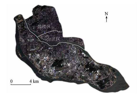
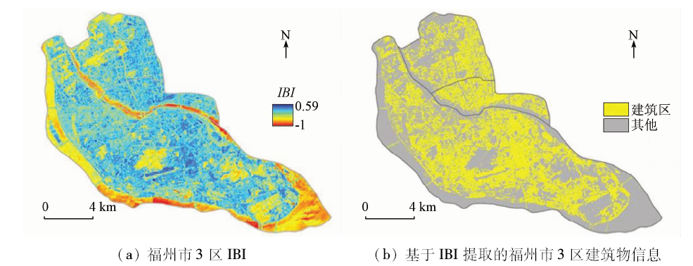
Abstract The urban roof greening has the effects such as water interception and ecological environment improvement, and can be an important part of sponge city construction. Taking Gulou, Taijiang, Cangshan Districts of Fuzhou City as the study objects and the remote sensing image of Landsat8 OLI as the main data, the authors extracted the roof greening rate based on sequential maximum angle convex cone(SMACC), constructed the relational models of roof greening rate and global vegetation moisture index(GVMI) humidity indicator, and then simulated and analyzed the roof greening rates. The results show that the roof greening rate in the three districts of Fuzhou is overall low, with an average of only 17.34%; the proportion of greening rate of 10%~20% is 66.55%, and only 5.11% is higher than 50%. The greening rates are different, and there are also changes in humidity, indicating that the roof vegetation has remarkable water interception capacity. The quadratic fumction model of roof humidity h and greening rate r is the optimization model. When the roof greening rate is higher than 16.30%, the intercepting effect begins to be obvious. In the process of greening rate increasing from 30% to 60%, the increasing speed of intercepting capacity becomes the fastest, with an average of up to 57.9%. Two typical blocks were selected and the roof greening rates were simulated and analyzed, which further proves the rationality of the above model. The result confirms the intercepting capacity of roof greening and determines the roof greening threshold under the target of water interception, which provides important reference for sponge city construction.
|
| Keywords
sponge city
roof greening rate
humidity
global vegetation moisture index(GVMI)
simulation
Fuzhou City
|
|
|
|
Corresponding Authors:
Zhanghua XU
E-mail: n160620002@fzu.edu.cn;fafuxzh@163.com
|
|
Issue Date: 30 May 2018
|
|
|
| [1] |
Dietz M E . Low impact development practices:A review of current research and recommendations for future directions[J]. Water,Air,and Soil Pollution, 2007,186(1/4):351-363.
doi: 10.1007/s11270-007-9484-z
url: http://link.springer.com/10.1007/s11270-007-9484-z
|
| [2] |
Church S P . Exploring Green Streets and rain gardens as instances of small scale nature and environmental learning tools[J]. Landscape and Urban Planning, 2015,134:229-240.
doi: 10.1016/j.landurbplan.2014.10.021
url: http://linkinghub.elsevier.com/retrieve/pii/S0169204614002539
|
| [3] |
Akbari H, Rose L S, Taha H . Analyzing the land cover of an urban environment using high-resolution orthophotos[J]. Landscape and Urban Planning, 2013,63(1):1-14.
doi: 10.1016/S0169-2046(02)00165-2
url: http://www.sciencedirect.com/science/article/pii/S0169204602001652
|
| [4] |
俞孔坚 . 海绵城市的三大关键策略:消纳、减速与适应[J].南方建筑, 2015(3):4-7.
doi: 10.3969/j.issn.1000-0232.2015.03.004
url: http://d.wanfangdata.com.cn/Periodical/nfjz201503002
|
| [4] |
Yu K J . Three key strategies to achieve a sponge city:Retention,slow down and adaptation[J].South Architecture, 2015(3):4-7.
|
| [5] |
俞孔坚 . 让水流慢下来——六盘水明湖湿地公园[J].建筑技艺, 2015(2):92-101.
doi: 10.3969/j.issn.1674-6635.2015.02.014
url: http://d.wanfangdata.com.cn/Periodical/jzjsjsj201502014
|
| [5] |
Yu K J . Slow down:Liupanshui Minghu wetland park[J].Architecture Technique, 2015(2):92-101.
|
| [6] |
刘昌明, 张永勇, 王中根 , 等. 维护良性水循环的城镇化LID模式:海绵城市规划方法与技术初步探讨[J]. 自然资源学报, 2016,31(5):719-731.
|
| [6] |
Liu C M, Zhang Y Y, Wang Z G , et al. The LID pattern for maintaining virtuous water cyclein urbanized area:A preliminary study of planning and techniques for sponge city[J]. Journal of Natural Resources, 2016,31(5):719-731.
|
| [7] |
明冬萍, 骆剑承, 沈占锋 , 等. 高分辨率遥感影像信息提取与目标识别技术研究[J]. 测绘科学, 2005,30(3):18-20.
doi: 10.3771/j.issn.1009-2307.2005.03.004
url: http://d.wanfangdata.com.cn/Periodical/chkx200503004
|
| [7] |
Ming D P, Luo J C, Shen Z F , et al. Research on information extraction and target recognition from high resolution remote sensing image[J]. Science of Surveying and Mapping, 2005,30(3):18-20.
|
| [8] |
Huston R, Chan Y C, Chapman H , et al. Source apportionment of heavy metals and ionic contaminants in rainwater tanks in a subtropical urban area in Australia[J]. Water Research, 2012,46(4):1121-1132.
doi: 10.1016/j.watres.2011.12.008
pmid: 22196953
url: http://linkinghub.elsevier.com/retrieve/pii/S0043135411007809
|
| [9] |
仇保兴 . 生态城改造分级关键技术[J].城市规划学刊, 2010(3):1-13.
doi: 10.3969/j.issn.1000-3363.2010.03.001
url: http://d.wanfangdata.com.cn/Periodical/csghhk201003001
|
| [9] |
Qiu B X . Key techniques in classification and reconstruction of ecological cities[J].Urban Planning Forum, 2010(3):1-13.
|
| [10] |
Oberndorfer E, Lundholm J, Bass B , et al. Green roofs as urban ecosystems:Ecological structures,functions,and services[J]. BioScience, 2007,57(10):823-833.
doi: 10.1641/B571005
url: http://academic.oup.com/bioscience/article/57/10/823/232363/Green-Roofs-as-Urban-Ecosystems-Ecological
|
| [11] |
邵天然, 李超骕, 曾辉 . 城市屋顶绿化资源潜力评估及绿化策略分析——以深圳市福田中心区为例[J]. 生态学报, 2012,32(3):4852-4860.
doi: 10.5846/stxb201110261592
url: http://d.wanfangdata.com.cn/Periodical/stxb201215027
|
| [11] |
Shao T R, Li C S, Zeng H . Resource potential assessment of urban roof greening and development strategies:A case study in Futian central district,Shenzhen,China[J]. Acta Ecologica Sinica, 2012,32(3):4852-4860.
|
| [12] |
Niu H, Clark C, Zhou J T , et al. Scaling of economic benefits from green roof implementation in Washington, DC[J]. Environmental Science and Technology, 2010,44(11):4302-4308.
doi: 10.1021/es902456x
pmid: 20462260
url: http://pubs.acs.org/doi/abs/10.1021/es902456x
|
| [13] |
Morales-Pinzón T, Rieradevall J, Gasol C M , et al. Modelling for economic cost and environmental analysis of rainwater harvesting systems[J]. Journal of Cleaner Production, 2015,87:613-626.
doi: 10.1016/j.jclepro.2014.10.021
url: http://linkinghub.elsevier.com/retrieve/pii/S0959652614010622
|
| [14] |
García-Montoya M, Bocanegra-Martínez A, Nápoles-Rivera F , et al. Simultaneous design of water reusing and rainwater harvesting systems in a residential complex[J]. Computers and Chemical Engineering, 2015,76:104-116.
doi: 10.1016/j.compchemeng.2015.02.011
url: http://linkinghub.elsevier.com/retrieve/pii/S0098135415000563
|
| [15] |
Ward S, Memon F A, Butler D . Performance of a large building rainwater harvesting system[J]. Water Research, 2012,46(16):5127-5134.
doi: 10.1016/j.watres.2012.06.043
pmid: 22840659
url: http://linkinghub.elsevier.com/retrieve/pii/S004313541200471X
|
| [16] |
Getter K L, Rowe D B, Andresen J A . Quantifying the effect of slope on extensive green roof stormwater retention[J]. Ecological Engineering, 2007,31(4):225-231.
doi: 10.1016/j.ecoleng.2007.06.004
url: http://linkinghub.elsevier.com/retrieve/pii/S0925857407001309
|
| [17] |
李沛鸿, 张晓玉 . 遥感在屋顶绿化调查中的应用研究[J]. 江西理工大学学报, 2011,32(5):16-18.
url: http://www.cqvip.com/QK/91391A/201105/39887827.html
|
| [17] |
Li P H, Zhang X Y . Research on remote sensing application in the investigation of green roof[J]. Journal of Jiangxi University of Science and Technology, 2011,32(5):16-18.
|
| [18] |
沈小乐, 邵振峰, 田英洁 . 纹理特征与视觉注意相结合的建筑区提取[J]. 测绘学报, 2014,43(8):842-847.
doi: j.cnki.11-2089.2014.0131
|
| [18] |
Shen X L, Shao Z F, Tian Y J . Build-up areas extraction by textural feature and visual attention mechanism[J]. Acta Geodaetica et Cartographica Sinica, 2014,43(8):842-847.
|
| [19] |
强永刚, 殷建平, 祝恩 , 等. 基于小波变换和数学形态学的遥感图像人工建筑区提取[J]. 中国图象图形学报, 2008,13(8):1459-1464.
doi: 10.11834/jig.20080812
|
| [19] |
Qiang Y G, Yin J P, Zhu E , et al. Extraction of building area from remote sensing images based on wavelets transformation and mathematical morphology[J]. Journal of Image and Graphics, 2008,13(8):1459-1464.
|
| [20] |
乔伟峰, 刘彦随, 项灵志 , 等. 无参数高分辨率遥感影像的建筑高度快速提取方法[J]. 地球信息科学学报, 2015,17(8):995-1000.
doi: 10.3724/SP.J.1047.2015.00995
|
| [20] |
Qiao W F, Liu Y S, Xiang L Z , et al. Research on extracting building height rapidly based on high-resolution remote sensing images without parameters[J]. Journal of Geo-Information Science, 2015,17(8):995-1000.
|
| [21] |
杨山 . 发达地区城乡聚落形态的信息提取与分形研究——以无锡市为例[J]. 地理学报, 2000,55(6):671-678.
doi: 10.3321/j.issn:0375-5444.2000.06.004
url: http://www.cqvip.com/Main/Detail.aspx?id=4743282
|
| [21] |
Yang S . On extraction and fractal of urban and rural residential spatial pattern in developed area[J]. Acta Geographica Sinica, 2000,55(6):671-678.
|
| [22] |
查勇, 倪绍祥, 杨山 . 一种利用TM图像自动提取城镇用地信息的有效方法[J]. 遥感学报, 2003,7(1):37-40.
doi: 10.11834/jrs.20030107
|
| [22] |
Zha Y, Ni S X, Yang S . An effective approach to automatically extract urban land-use from TM imagery[J]. Journal of Remote Sensing, 2003,7(1):37-40.
|
| [23] |
徐涵秋 . 一种基于指数的新型遥感建筑用地指数及其生态环境意义[J]. 遥感技术与应用, 2007,22(3):301-308.
doi: 10.3969/j.issn.1004-0323.2007.03.001
url: http://d.wanfangdata.com.cn/Periodical/ygjsyyy200703001
|
| [23] |
Xu H Q . A new index-based built-up index(IBI) and its eco-environmental significance[J]. Remote Sensing Technology and Application, 2007,22(3):301-308.
|
| [24] |
崔一娇, 朱琳, 赵力娟 . 基于面向对象及光谱特征的植被信息提取与分析[J]. 生态学报, 2013,33(3):867-875.
doi: 10.5846/stxb201204110510
url: http://www.cqvip.com/qk/90772x/201303/44796886.html
|
| [24] |
Cui Y J, Zhu L, Zhao L J . Abstraction and analysis of vegetation information based on object-oriented and spectra features[J]. Acta Ecologica Sinica, 2013,33(3):867-875.
|
| [25] |
崔天翔, 宫兆宁, 赵文吉 , 等. 不同端元模型下湿地植被覆盖度的提取方法——以北京市野鸭湖湿地自然保护区为例[J]. 生态学报, 2013,33(4):1160-1171.
doi: 10.5846/stxb201204270604
url: http://doi.med.wanfangdata.com.cn/10.5846/stxb201204270604
|
| [25] |
Cui T X, Gong Z N, Zhao W J , et al. Research on estimating wetland vegetation abundance based on spectral mixture analysis with different endmember model:A case study in Wild Duck Lake wetland,Beijing[J]. Acta Ecologica Sinica, 2013,33(4):1160-1171.
|
| [26] |
Roberts D A, Gardner M, Church R , et al. Mapping chaparral in the Santa Monica Mountains using multiple endmember spectral mixture models[J]. Remote Sensing of Environment, 1998,65(3):267-279.
doi: 10.1016/S0034-4257(98)00037-6
url: http://linkinghub.elsevier.com/retrieve/pii/S0034425798000376
|
| [27] |
Ichoku C, Karnieli A . A review of mixture modeling techniques for sub-pixel land cover estimation[J]. Remote Sensing Reviews, 1996,13(3/4):161-186.
doi: 10.1080/02757259609532303
url: http://www.tandfonline.com/doi/abs/10.1080/02757259609532303
|
| [28] |
杨苏新, 张霞, 帅通 , 等. 基于混合像元分解的喀斯特石漠化地物丰度估测[J]. 遥感技术与应用, 2014,29(5):823-832.
doi: 10.11873/j.issn.10040323.2014.5.0823
|
| [28] |
Yang S X, Zhang X, Shuai T , et al. Estimating Karst rocky desertification feature abundance by pixel unmixing[J]. Remote Sensing Technology and Application, 2014,29(5):823-832.
|
| [29] |
张雪红, 田庆久 . 利用温湿度指数提高红树林遥感识别精度[J]. 国土资源遥感, 2012,24(3):65-70.doi: 10.6046/gtzyyg.2012.03.13.
doi: 10.6046/gtzyyg.2012.03.13
url: http://d.wanfangdata.com.cn/Periodical/gtzyyg201203013
|
| [29] |
Zhang X H, Tian Q J . Application of the temperature-moisture index to the improvement of remote sensing identification accuracy of mangrove[J]. Remote Sensing for Land and Resources, 2012,24(3):65-70.doi: 10.6046/gtzyyg.2012.03.13.
|
| [30] |
徐涵秋 . 区域生态环境变化的遥感评价指数[J]. 中国环境科学, 2013,33(5):889-897.
doi: 10.3969/j.issn.1000-6923.2013.05.019
url: http://d.wanfangdata.com.cn/Periodical/zghjkx201305019
|
| [30] |
Xu H Q . A remote sensing index for assessment of regional ecological changes[J]. China Environmental Science, 2013,33(5):889-897.
|
| [31] |
周秉荣, 李凤霞, 申双和 , 等. 从MODIS资料提取土壤湿度信息的主成分分析方法[J]. 应用气象学报, 2009,20(1):114-118.
doi: 10.3969/j.issn.1001-7313.2009.01.015
url: http://d.wanfangdata.com.cn/Periodical/yyqxxb200901015
|
| [31] |
Zhou B R, Li F X, Shen S H , et al. Principal component analysis method acquiring soil moisture information from MODIS data[J]. Journal of Applied Meteorological Science, 2009,20(1):114-118.
|
| [32] |
谷松岩, 李万彪, 张文建 . 利用TRMM/TMI资料提取地表层湿度信息试验[J]. 遥感学报, 2005,9(2):166-175.
doi: 10.3321/j.issn:1007-4619.2005.02.009
url: http://d.wanfangdata.com.cn/Periodical/ygxb200502009
|
| [32] |
Gu S Y, Li W B, Zhang W J . Retrieving soil moisture from TRMM/TMI[J]. Journal of Remote Sensing, 2005,9(2):166-175.
|
| [33] |
Ceccato P, Flasse S, Grégoire J M . Designing a spectral index to estimate vegetation water content from remote sensing data:Part 2.Validation and applications[J]. Remote Sensing of Environment, 2002,82(2/3):198-207.
doi: 10.1016/S0034-4257(02)00036-6
url: http://linkinghub.elsevier.com/retrieve/pii/S0034425702000366
|
|
Viewed |
|
|
|
Full text
|
|
|
|
|
Abstract
|
|
|
|
|
Cited |
|
|
|
|
| |
Shared |
|
|
|
|
| |
Discussed |
|
|
|
|
 2018,
Vol. 30
2018,
Vol. 30