|
|
 |
|

|
|
|
Dynamic simulation of multi-scenario land use change based on CLUMondo model: A case study of coastal cities in Guangxi |
| Ruiqi GUO, Bo LU, Kailin CHEN |
| School of Public Administration, Guangxi University, Nanning 530004, China |
|
|
|
|
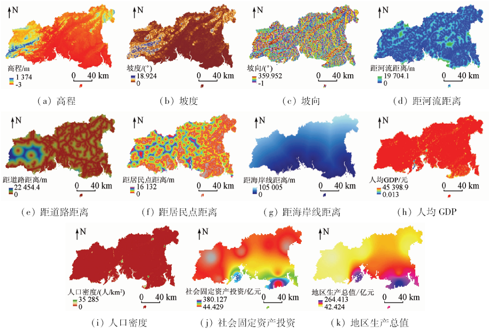
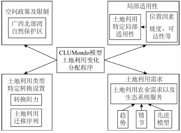
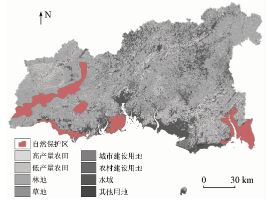
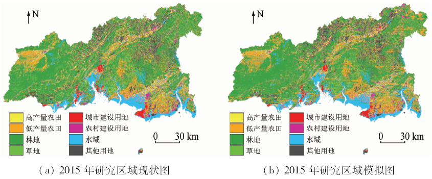
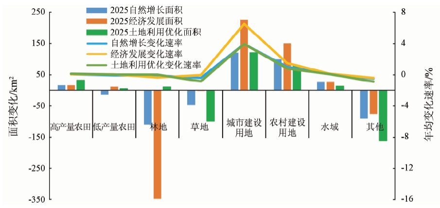
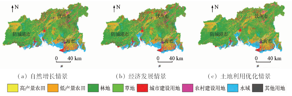
Abstract In this study, the authors used the CLUMondo model which can deeply describe the intensity of land and the land use data of 2010 and 2015 to simulate the spatial distribution pattern of land use in the three different scenarios of “natural growth”, “economic development” and “land use optimization” in coastal cities of Guangxi in 2025. Some conclusions have been reached: The CLUMondo model can effectively simulate the development status and trajectory of land system in large-scale coastal areas; under the“natural growth” scenario, the intensive and effective use of land resources in coastal cities has been slower; under the “economic development” scenario, urban and rural construction land is growing rapidly and is closely related in space. There is a sharp contradiction between regional forest and cultivated land protection and industrial construction; under the “land use optimization” scenario, the pace of regional economic construction has gradually slowed down, and the construction of regional cities has formed a trend of concentration of resources to cities and towns and concentration of farmlands. The simulation results provide a certain reference for the future land use planning and related system formulation of coastal cities in Guangxi and even the whole country.
|
| Keywords
land use change simulation
coastal city
CLUMondo model
|
|
|
|
Issue Date: 14 March 2020
|
|
|
| [1] |
Liu J, Hong L I, Ma Y G . Analysis and prediction of land use change in typical city of central asia based on CA-Markov model[J]. Research of Soil and Water Conservation, 2014. 21(3):51-56.
|
| [2] |
Parker D C, Manson S M, Janssen M A , et al. Multi-agent systems for the simulation of land-use and land-cover change:A review[J]. Annals of the Association of American Geographers, 2003,93(2):314-337.
|
| [3] |
Halmy M W A, Gessler P E, Hicke J A , et al. Land use/land cover change detection and prediction in the north-western coastal desert of Egypt using Markov-CA[J]. Applied Geography, 2015,63:101-112.
|
| [4] |
汪佳莉, 吴国平, 范庆亚 , 等. 基于CA-Markov模型的山东省临沂市土地利用格局变化研究及预测[J]. 水土保持研究, 2015,22(1):212-216.
|
| [4] |
Wang J L, Wu G P, Fan Q Y , et al. Study and prediction of land use pattern change in Linyi City,Shandong Province based on CA-Markov model[J]. Soil and Water Conservation Research, 2015,22(1):212-216.
|
| [5] |
Yuan M A, Huang C, Zheng W . Analysis and prediction of land use change in Maqu County[J]. Arid Zone Research, 2012,29(4):735-741.
|
| [6] |
王崇倡, 张畅 . 基于遗传BP神经网络模型的土地利用变化预测模型研究[J]. 测绘与空间地理信息, 2017,40(2):52-55.
|
| [6] |
Wang C C, Zhang C . Study on land use change prediction model based on genetic BP neural network model[J]. Mapping and Spatial Geographic Information, 2017,40(2):52-55.
|
| [7] |
Verburg P H, Soepboer W, Veldkamp A , et al. Modeling the spatial dynamics of regional land use:The CLUE-S model[J]. Environmental Management, 2002,30(3):391-405.
|
| [8] |
Mishra V N, Rai P K, Mohan K . Prediction of land use changes based on land change modeler (LCM) using remote sensing:A case study of Muzaffarpur (Bihar),India[J]. Journal of the Geographical Institute Jovan Cvijic Sasa, 2014,64(1):111-127.
|
| [9] |
Oh Y G, Yoo S H, Lee S H , et al. Prediction of paddy field change based on climate change scenarios using the CLUE model[J]. Paddy and Water Environment, 2011,9(3):309-323.
|
| [10] |
Mtu R, Tabassum F, Rasheduzzaman M , et al. Temporal dynamics of land use/land cover change and its prediction using CA-ANN model for southwestern coastal Bangladesh[J]. Environmental Monitoring and Assessment, 2017,189(11):565.
|
| [11] |
Etemadi H, Smoak J M, Karami J . Land use change assessment in coastal mangrove forests of Iran utilizing satellite imagery and CA-Markov algorithms to monitor and predict future change[J]. Environmental Earth Sciences, 2018,77(5):208.
|
| [12] |
Pourebrahim S, Hadipour M, Mokhtar M B . Impact assessment of rapid development on land use changes in coastal areas:Case of Kuala Langat District,Malaysia[J]. Environment Development and Sustainability, 2015,17(5):1003-1016.
|
| [13] |
Asselen S, Verburg P H . Land cover change or land-use intensification:Simulating land system change with a global-scale land change model[J]. Global Change Biology, 2013,19(12):3648.
|
| [14] |
谢莹, 匡鸿海, 吴晶晶 , 等. 基于CLUE-S模型的重庆市渝北区土地利用变化动态模拟[J]. 长江流域资源与环境, 2016,25(11):1729-1737.
|
| [14] |
Xie Y, Kuang H H, Wu J J , et al. Dynamic simulation of land use change in Yubei District of Chongqing City based on CLUE-S model[J]. Resources and Environment of Yangtze River Basin, 2016,25(11):1729-1737.
|
| [15] |
苏红帆, 侯西勇, 邸向红 . 北部湾沿海土地利用变化时空特征及情景分析[J]. 海洋科学, 2016,40(9):107-116.
|
| [15] |
Su H F, Hou X Y, Di X H . Spatial-temporal characteristics and scenario analysis of land use change along the Beibu Gulf coast[J]. Marine Science, 2016,40(9):107-116.
|
| [16] |
马金卫, 吴晓青, 周迪 , 等. 海岸带城镇空间扩展情景模拟及其生态风险评价[J]. 资源科学, 2012,34(1):185-194.
|
| [16] |
Ma J W, Wu X Q, Zhou D , et al. Scene simulation and ecological risk assessment of urban spatial expansion in coastal zone[J]. Resource Science, 2012,34(1):185-194.
|
| [17] |
潘润秋, 罗启源, 肖迪 , 等. 基于CLUE-S模型的深圳海岸带土地利用变化模拟[J]. 测绘与空间地理信息, 2016,39(4):32-36.
|
| [17] |
Pan R Q, Luo Q Y, Xiao D , et al. Land use change simulation of Shenzhen coastal zone based on CLUE-S model[J]. Mapping and spatial geographic information, 2016,39(4):32-36.
|
| [18] |
吴莉, 侯西勇 . 基于Spatial-Markov模型的胶东半岛土地利用变化模拟与预测[C]// 2012自然地理学与生态安全学术研讨会.兰州, 2012: 53.
|
| [18] |
Wu L, Hou X Y . Jiaodong Peninsula land use change simulation and prediction based on Spatial-Markov model[C]// 2012 Symposium on Physical Geography and Ecological Security.Lanzhou, 2012: 53.
|
| [19] |
Liu W, Zhang L, Zhu J . Notice of retraction prediction of land use in Liaoning coastal economic zone based on CLUE-S[C]// Iita International Conference on Geoscience and Remote Sensing. 2010: 19-22.
|
| [20] |
Eitelberg D A, Vliet J V, Doelman J C , et al. Demand for biodiversity protection and carbon storage as drivers of global land change scenarios[J]. Global Environmental Change, 2016,40:101-111.
|
| [21] |
Asselen S V, Verburg P H . Land cover change or land-use intensification:Simulating land system change with a global-scale land change model[J]. Global Change Biology, 2013,19(12):3648.
|
| [22] |
Debonne N, Vliet J V, Heinimann A , et al. Representing large-scale land acquisitions in land use change scenarios for the Lao PDR[J]. Regional Environmental Change, 2018: 1-13.
|
| [23] |
Vliet J V, Verburg P H . A Short Presentation of CLUMondo[M]// Geomatic Approaches for Modeling Land Change Scenarios. 2018.
|
| [24] |
Rahman M, Tabassum F, Rasheduzzaman M , et al. Temporal dynamics of land use/land cover change and its prediction using CA-ANN model for southwestern coastal Bangladesh[J]. Environmental Monitoring and Assessment, 2017,189(11):565.
|
| [25] |
邓华, 邵景安, 王金亮 , 等. 多因素耦合下三峡库区土地利用未来情景模拟[J]. 地理学报, 2016,71(11):1979-1997.
|
| [25] |
Deng H, Shao J A, Wang J L , et al. Multi-factor coupling simulation of future land use scenarios in the Three Gorges Reservoir area[J]. Journal of Geography, 2016,71(11):1979-1997.
|
| [26] |
Ornetsmüller C, Verburg P H, Heinimann A . Scenarios of land system change in the Lao PDR:Transitions in response to alternative demands on goods and services provided by the land[J]. Applied Geography, 2016,75:1-11.
|
| [27] |
李伟, 张翠萍, 李士美 . 基于第8次森林资源清查数据的广西森林碳储量特征研究[J]. 西南林业大学学报, 2017,37(3):127-133.
|
| [27] |
Li W, Zhang C P, Li S M . A study on the characteristics of forest carbon reserves in Guangxi based on the data of the 8th forest resources inventory[J]. Journal of Southwest Forestry University, 2017,37(3):127-133.
|
|
Viewed |
|
|
|
Full text
|
|
|
|
|
Abstract
|
|
|
|
|
Cited |
|
|
|
|
| |
Shared |
|
|
|
|
| |
Discussed |
|
|
|
|
 2020,
Vol. 32
2020,
Vol. 32