|
|
 |
|

|
|
|
Simulation of land use change in oasis of arid areas based on Landsat images from 1990 to 2019 |
SONG Qi1( ), FENG Chunhui1, MA Ziqiang2, WANG Nan3, JI Wenjun4, PENG Jie1() ), FENG Chunhui1, MA Ziqiang2, WANG Nan3, JI Wenjun4, PENG Jie1() |
1. College of Agriculture, Tarim University, Alar 843300, China
2. Institute of Remote Sensing and Geographical Information Systems, School of Earth and Space Sciences, Peking University, Beijing 100871, China
3. College of Environmental and Resource Science, Zhejiang University, Hangzhou 310058, China
4. College of Land Science and Technology, China Agricultural University, Beijing 100083, China |
|
|
|
|
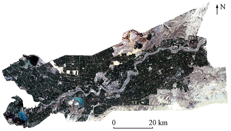
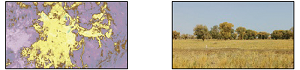
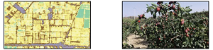
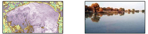
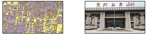
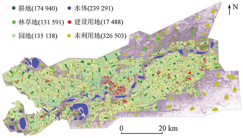
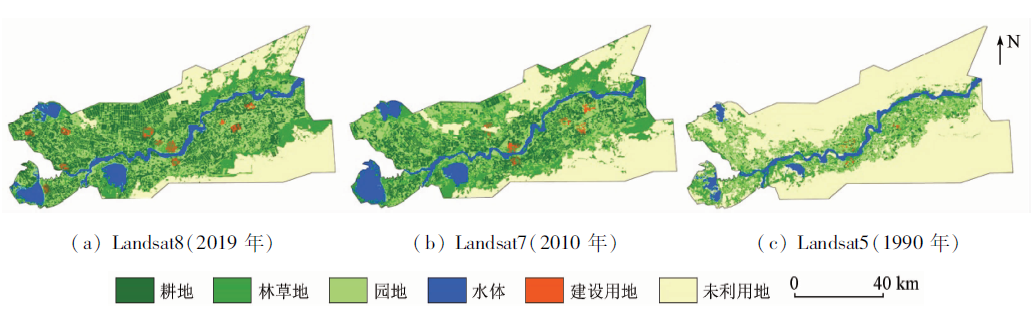
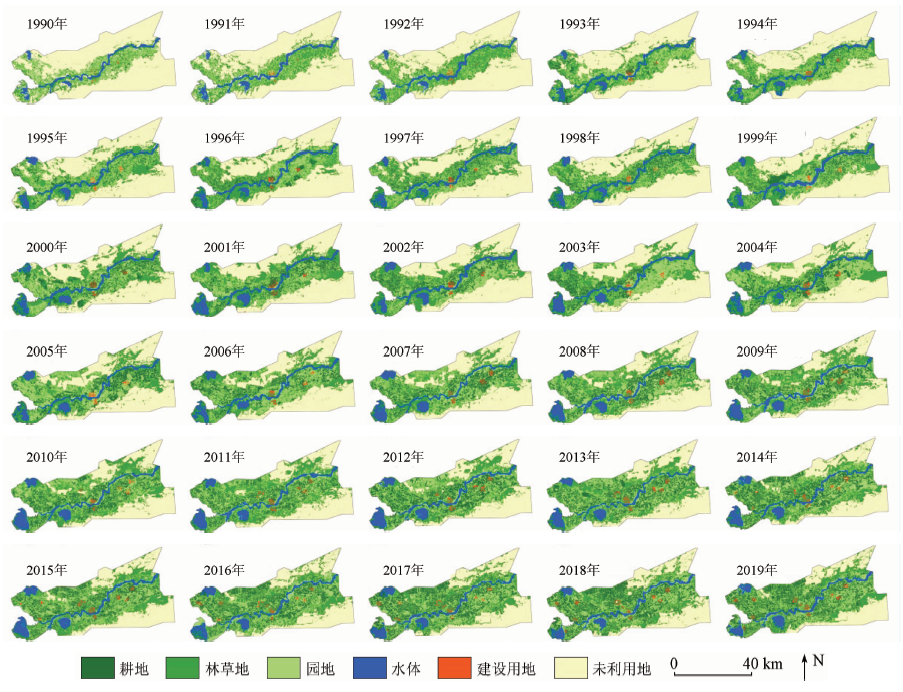
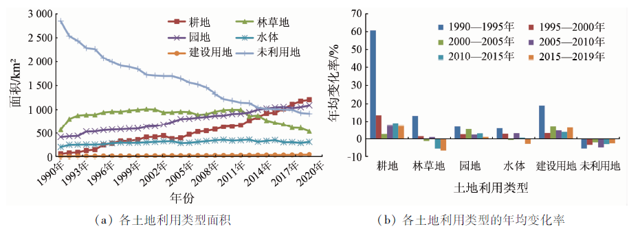
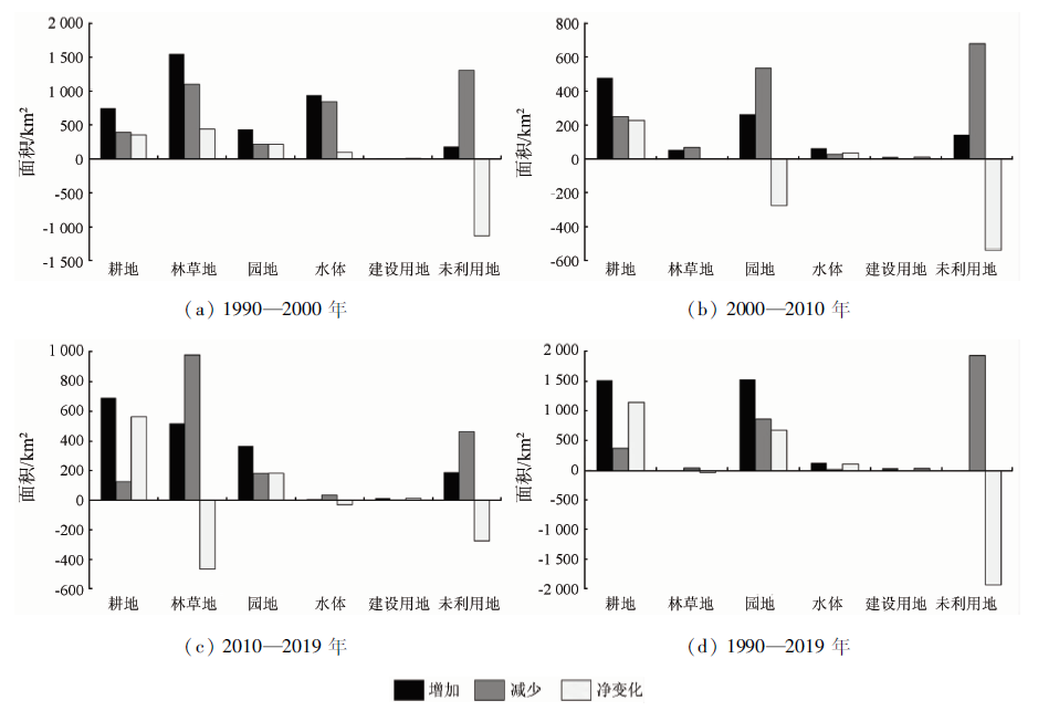
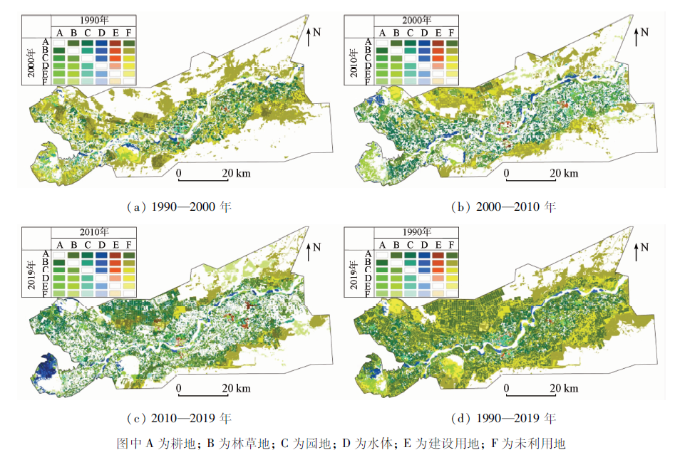
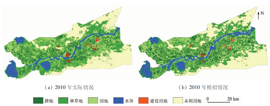
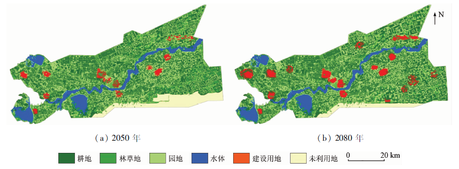
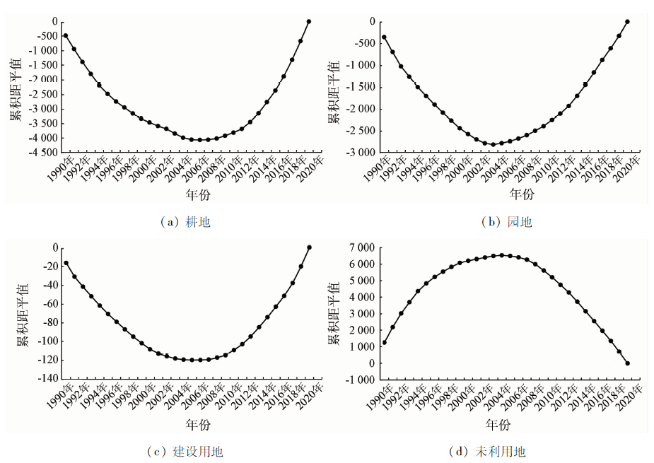
Abstract This study aims to explore the land use change and its future development trend in the Aral reclamation area, a typical artificial oasis in the arid region in northwest China and to provide a reference for the regulation and management of land use change in similar areas. After the multi-temporal synthesis of monthly images of each year, annual land use classification maps were obtained using the support vector machine method. Then, the land use change was analyzed from the aspects of area change, type transformation, and spatial dynamic change. Finally, the cellular automaton (CA)-Markov model was used to simulate the land use change in 2050 and 2080, and the sudden changes and their driving factors were explored using the cumulative departure method and the path analysis. The results of this study are as follows. During 1990—2019, the area of arable land, garden land, water bodies, and construction land in the Aral reclamation area showed an increasing trend. Among them, the arable land and garden land increased in area mainly due to the conversion of unused land outside the areas along the Tarim River. By 2080, the unused land in the northeastern and southeastern parts of the reclamation area will be gradually reclaimed. As a result, arable land, garden land, and construction land will significantly increase. The area of various types of land use in the Aral reclamation reached a turning point in 2005, showing a sharp increase in the area of arable land, garden land, and building land. This was mainly driven by total population, gross agricultural product, and cotton prices. It can be concluded that it is necessary to develop policies on the sustainable development of arable land, to strictly control the area of construction land, and to construct a reasonable land use structure in future land development and utilization.
|
| Keywords
land use change
dynamic simulation of land space
long time series
driving factors
|
|
|
|
Corresponding Authors:
PENG Jie
E-mail: tarimsongqi@163.com;pjzky@163.com
|
|
Issue Date: 14 March 2022
|
|
|
| [1] |
董祚继. 从土地利用规划到国土空间规划——科学理性规划的视角[J]. 中国土地科学, 2020, 34(5):1-7.
|
| [1] |
Dong Q J. From land-use planning to territorial space planning:A perspective of scientific and rational planning[J]. China Land Science, 2020, 34(5):1-7.
|
| [2] |
胡苏李扬, 李辉, 顾延生, 等. 基于高分辨率遥感影像的神农架大九湖湿地土地利用类型变化及其驱动力分析——来自长时间尺度多源遥感信息的约束[J]. 自然资源遥感, 2021, 33(1):221-230.doi: 10.6046/gtzyyg.2020100.
doi: 10.6046/gtzyyg.2020100
|
| [2] |
Hu S L Y, Li H, Gu Y S, et al. An analysis of land use changes and driving forces of Dajiuhu wetland in Shennongjia based on high reso-lution remote sensing images:Constraints from the multi-source and long-term remote sensing information[J]. Remote Sensing for Land and Resources, 2021, 33(1):221-230.doi: 10.6046/gtzyyg.2020100.
doi: 10.6046/gtzyyg.2020100
|
| [3] |
Yu H, Liu X M, Kong B, et al. Landscape ecology development supported by geospatial technologies:A review[J]. Ecological Informatics, 2019, 51:185-192.
doi: 10.1016/j.ecoinf.2019.03.006
url: https://linkinghub.elsevier.com/retrieve/pii/S1574954119300329
|
| [4] |
高文龙, 苏腾飞, 张圣微, 等. 矿区地物分类及土地利用/覆盖变化动态监测——以海流兔流域为例[J]. 自然资源遥感, 2020, 32(3):232-239.doi: 10.6046/gtzyyg.2020.03.30.
doi: 10.6046/gtzyyg.2020.03.30
|
| [4] |
Gao W L, Su T F, Zhang S W, et al. Classification of objects and LUCC dynamic monitoring in mining area:A case study of Hailiutu watershed[J]. Remote Sensing for Land and Resources, 2020, 32(3):232-239.doi: 10.6046/gtzyyg.2020.03.30.
doi: 10.6046/gtzyyg.2020.03.30
|
| [5] |
Guo Y, Fang G, Xu Y P, et al. Identifying how future climate and land use/cover changes impact streamflow in Xinanjiang Basin,East China[J]. Science of the Total Environment, 2020, 710:136275.
doi: 10.1016/j.scitotenv.2019.136275
url: https://linkinghub.elsevier.com/retrieve/pii/S0048969719362710
|
| [6] |
Chen L D, Liu Y, Lyu Y H, et al. Pattern analysis in landscape ecolo-gy:Progress,challenges and outlook[J]. Acta Ecologica Sinica, 2008, 28(11):5521-5531.
doi: 10.1016/S1872-2032(09)60011-1
url: https://linkinghub.elsevier.com/retrieve/pii/S1872203209600111
|
| [7] |
杜金龙, 朱记伟, 解建仓, 等. 基于GIS的城市土地利用研究进[J]. 自然资源遥感, 2018, 30(3):9-17.doi: 10.6046/gtzyyg.2018.03.02.
doi: 10.6046/gtzyyg.2018.03.02
|
| [7] |
Du J L, Zhu J W, Xie J C, et al. An overview of urban land use research based on GIS[J]. Remote Sensing for Land and Resources, 2018, 30(3):9-17.doi: 10.6046/gtzyyg.2018.03.02.
doi: 10.6046/gtzyyg.2018.03.02
|
| [8] |
张瑜, 赵晓丽, 左丽君, 等. 黄土高原土地利用变化对生态系统服务价值的影响[J]. 自然资源遥感, 2019, 31(3):132-139.doi: 10.6046/gtzyyg.2019.03.17.
doi: 10.6046/gtzyyg.2019.03.17
|
| [8] |
Zhang Y, Zhao X L, Zuo L J, et al. The impact of land use change on ecosystem services value in Loess Plateau[J]. Remote Sensing for Land and Resources, 2019, 31(3):132-139.doi: 10.6046/gtzyyg.2019.03.17.
doi: 10.6046/gtzyyg.2019.03.17
|
| [9] |
Wang Y H, Dai E F, Yin L, et al. Land use/land cover change and the effects on ecosystem services in the Hengduan Mountain region,China[J]. Ecosystem Services, 2018, 34(a):55-67.
doi: 10.1016/j.ecoser.2018.09.008
url: https://linkinghub.elsevier.com/retrieve/pii/S2212041618300652
|
| [10] |
Wang J, Chen Y Q, Shao X M, et al. Land-use changes and policy dimension driving forces in China:Present,trend and future[J]. Land Use Policy, 2012, 29(4):737-749.
doi: 10.1016/j.landusepol.2011.11.010
url: https://linkinghub.elsevier.com/retrieve/pii/S0264837711001372
|
| [11] |
Wu J G. Landscape ecology[J]. Encyclopedia of Ecology(Second Edition), 2019, 4:527-531.
|
| [12] |
Antrop M. The language of landscape ecologists and planners:A comparative content analysis of concepts used in landscape ecology[J]. Landscape and Urban Planning, 2001, 55(3):163-173.
doi: 10.1016/S0169-2046(01)00151-7
url: https://linkinghub.elsevier.com/retrieve/pii/S0169204601001517
|
| [13] |
Liu Y L, Luo T, Liu Z Q, et al. A comparative analysis of urban and rural construction land use change and driving forces:Implications for urbanerural coordination development in Wuhan[J]. Central China.Habitat International, 2015, 47:113-125.
|
| [14] |
Kabisch N, Selsam P, Kirsten T, et al. A multi-sensor and multi-temporal remote sensing approach to detect land cover change dynamics in heterogeneous urban landscapes[J]. Ecological Indicators, 2019, 99:273-282.
doi: 10.1016/j.ecolind.2018.12.033
|
| [15] |
Zhao L, Huang W, Chen J, et al. Land use/cover changes in the Oriental migratory locust area of China:Implications for ecological control and monitoring of locust area[J]. Agriculture,Ecosystems and Environment, 2020, 303:107110.
doi: 10.1016/j.agee.2020.107110
url: https://linkinghub.elsevier.com/retrieve/pii/S0167880920302966
|
| [16] |
Shen S G, Yue P, Fan C J. Quantitative assessment of land use dynamic variation using remote sensing data and landscape pattern in the Yangtze River delta,China[J]. Sustainable Computing:Informatics and Systems, 2019, 23:111-119.
doi: 10.1016/j.suscom.2019.07.006
url: https://linkinghub.elsevier.com/retrieve/pii/S2210537919300101
|
| [17] |
Wang X C, Dong X B, Liu H M, et al. Linking land use change,ecosystem services and human well-being:A case study of the Manas River basin of Xinjiang,China[J]. Ecosystem Services, 2017, 27(a):113-123.
doi: 10.1016/j.ecoser.2017.08.013
url: https://linkinghub.elsevier.com/retrieve/pii/S2212041617301195
|
| [18] |
Jia B Q, Zhang Z Q, Ci L G, et al. Oasis land-use dynamics and its influence on the oasis environment in Xinjiang,China[J]. Journal of Arid Environments, 2004, 56(1):11-26.
doi: 10.1016/S0140-1963(03)00002-8
url: https://linkinghub.elsevier.com/retrieve/pii/S0140196303000028
|
| [19] |
Tian G J, Liu J Y, Xie Y C, et al. Analysis of spatio-temporal dynamic pattern and driving forces of urban land in China in 1990s using TM images and GIS[J]. Cities, 2005, 22(6):400-410.
doi: 10.1016/j.cities.2005.05.009
url: https://linkinghub.elsevier.com/retrieve/pii/S0264275105000545
|
| [20] |
岳东霞, 杨超, 江宝骅, 等. 基于CA-Markov模型的石羊河流域生态承载力时空格局预测[J]. 生态学报, 2019, 39(6):1993-2003.
|
| [20] |
Yue D X, Yang C, Jiang B H, et al. Spatio-temporal pattern prediction of the biocapacity in the Shiyang River basin on the basis of the CA-Markov model[J]. Acta Ecologica Sinica, 2019, 39(6):1993-2003.
|
| [21] |
郭瑞琦, 陆波, 陈恺霖. 基于CLUMondo模型的多情景土地利用变化动态模拟——以广西沿海城市为例[J]. 自然资源遥感, 2020, 32(1):176-183.doi: 10.6046/gtzyyg.2020.01.24.
doi: 10.6046/gtzyyg.2020.01.24
|
| [21] |
Guo R Q, Lu B, Chen K L. Dynamic simulation of multi-scenario land use change based on CLUMondo model:A case study of coastal cities in Guangxi[J]. Remote Sensing for Land and Resources, 2020, 32(1):176-183.doi: 10.6046/gtzyyg.2020.01.24.
doi: 10.6046/gtzyyg.2020.01.24
|
| [22] |
季翔, 黄炎和, 林金石, 等. 基于CA-Markov模型与ANUDEM内插法的崩岗侵蚀量预估[J]. 农业工程学报, 2018, 34(21):128-136.
|
| [22] |
Ji X, Huang Y H, Lin J S, et al. Estimation of erosion amount in collapsed gully based on CA-Markov model and ANUDEM interpolation[J]. Transactions of the Chinese Society of Agricultural Engineering, 2018, 34(21):128-136.
|
| [23] |
成超男, 胡杨, 冯尧, 等. 基于CA-Markov模型的城市生态分区构建研究——以晋中主城区为例[J]. 生态学报, 2020, 40(4):1455-1462.
|
| [23] |
Chen C N, Hu Y, Feng Y, et al. Construction of urban ecological zones based on CA-Markov model:A case study of the main urban of Jinzhong[J]. Acta Ecologica Sinica, 2020, 40(4):1455-1462.
|
| [24] |
Matsa M, Mupepi O, Musasa T, et al. A GIS and remote sensing aided assessment of land use/cover changes in resettlement areas:A case of ward 32 of Mazowe district,Zimbabwe[J]. Journal of Environmental Management, 2020, 276:111312.
doi: S0301-4797(20)31235-4
pmid: 32927188
|
| [25] |
夏芳. 钱塘江流域气候变化及其对水文径流的影响[D]. 杭州:浙江大学, 2016.
|
| [25] |
Xia F. Climate change in the Qiantang River basin and its influence on local runoff[D]. Hangzhou:Zhejiang University, 2016.
|
| [26] |
Zhuang Q W, Wu S X, Yan Y Y, et al. Monitoring land surface thermal environments under the background of landscape patterns in arid regions:A case study in Aksu River basin[J]. Science of the Total Environment, 2020, 710(25):136336.
doi: 10.1016/j.scitotenv.2019.136336
url: https://linkinghub.elsevier.com/retrieve/pii/S0048969719363326
|
| [27] |
陶帅, 邝婷婷, 彭文甫, 等. 2000—2015年长江上游NDVI时空变化及驱动力——以宜宾市为例[J]. 生态学报, 2020, 40(14):5029-5043.
|
| [27] |
Tao S, Kuang T T, Peng W F, et al. Analyzing the spatio-temporal variation and drivers of NDVI in upper reaches of the Yangtze River from 2000 to 2015:A case study of Yibin City[J]. Acta Ecologica Sinica, 2020, 40(14):5029-5043.
|
| [28] |
Fan Q D, Ding S Y. Landscape pattern changes at a county scale:A case study in Fengqiu,Henan Province,China from 1990 to 2013[J]. Catena, 2016, 137:152-160.
doi: 10.1016/j.catena.2015.09.012
url: https://linkinghub.elsevier.com/retrieve/pii/S0341816215301120
|
| [29] |
袁静文, 武辰, 杜博, 等. 高分五号高光谱遥感影像的城市土地利用景观格局分析[J]. 遥感学报, 2020, 24(4):465-478.
|
| [29] |
Yuan J W, Wu C, Du B, et al. Analysis of landscape pattern on urban land use based on GF-5 hyperspectral data[J]. Journal of Remote Sensing, 2020, 24(4):465-478.
|
| [30] |
朱永森, 曾永年, 张猛. 基于HJ卫星数据与面向对象分类的土地利用/覆盖信息提取[J]. 农业工程学报, 2017, 33(14):258-265.
|
| [30] |
Zhu Y S, Zeng Y N, Zhang M. Extract of land use/cover information based on HJ satellites data and object-oriented classification[J]. Transactions of the Chinese Society of Agricultural Engineering, 2017, 33(14):258-265.
|
| [31] |
朱金峰, 周艺, 王世新, 等. 1975—2018年白洋淀湿地变化分析[J]. 遥感学报, 2019, 23(5):971-986.
|
| [31] |
Zhu J F, Zhou Y, Wang S X, et al. Analysis of changes of Baiyangdian wetland from 1975 to 2018 based on remote sensing[J]. Journal of Remote Sensing, 2019, 23(5):971-986.
|
| [32] |
刘敬杰, 夏敏, 刘友兆, 等. 基于多智能体与CA结合模型分析的农村土地利用变化驱动机制[J]. 农业工程学报, 2018, 34(6):242-252.
|
| [32] |
Liu J J, Xia M, Liu Y Z, et al. Driving mechanism of rural land use change based on multi-agent system and cellular automata[J]. Transactions of the Chinese Society of Agricultural Engineering, 2018, 34(6):242-252.
|
| [33] |
王兆林, 牙升业, 蒲海霞, 等. 基于改进CA-Markov模型的山地城市边缘区土地利用变化模拟[J]. 农业工程学报, 2020, 36(16):239-248.
|
| [33] |
Wang Z L, Ya S Y, Pu H X, et al. Simulation of spatiotemporal variation of land use in mountainous-urban fringes based on improved CA-Markov model[J]. Transactions of the Chinese Society of Agricultural Engineering, 2020, 36(16):239-248.
|
| [34] |
李少英, 刘小平, 黎夏, 等. 土地利用变化模拟模型及应用研究进展[J]. 遥感学报, 2017, 21(3):329-340.
|
| [34] |
Li S Y, Liu X P, Li X, et al. Simulation model of land use dynamics and application:Progress and prospects[J]. Journal of Remote Sensing, 2017, 21(3):329-340.
|
|
Viewed |
|
|
|
Full text
|
|
|
|
|
Abstract
|
|
|
|
|
Cited |
|
|
|
|
| |
Shared |
|
|
|
|
| |
Discussed |
|
|
|
|
 2022,
Vol. 34
2022,
Vol. 34