|
|
 |
|

|
|
|
Atmospheric correction of Worldview3 image based on FLAASH model |
| Ling CHEN, Li CHEN, Wei LI, Jianyu LIU |
| China Aero Geophysical Survey and Remote Sensing Center for Natural Resources, Beijing 100083, China |
|
|
|
|
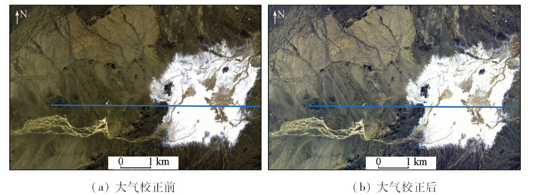
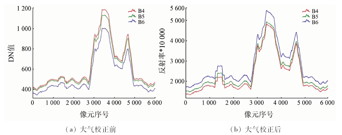
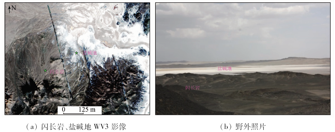
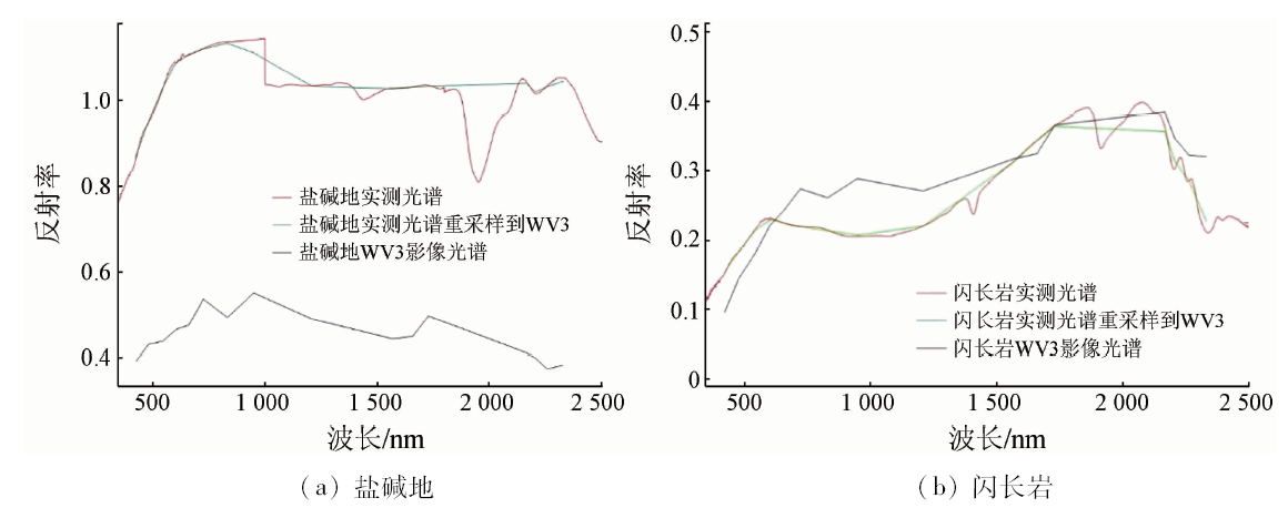
Abstract With the development of remote sensing technology, the remote sensing has been developed from qualitative application to quantitative application,and atmospheric correction is an important part of quantitative remote sensing research. In this study, the authors used the FLAASH model of ENVI software to conduct atmospheric correction for Worldview3, a satellite image with high spatial resolution and high spectral resolution, and then evaluated the method. Worldview3 data and ASD measurement spectral data of typical ground objects(saline-alkali land and diorite)in Lop Nur were obtained. Firstly, the DN value of Worldview3 was converted into radiation brightness and apparent reflectance, and the atmosphere correction of Worldview3 image was carried out by using FLAASH model. The radiation brightness, apparent reflectance and FLAASH atmospheric corrected reflectance of two typical ground objects (saline-alkali land and diorite) in the study area were comparatively studied, and the measured reflection spectra of saline-alkali and diorite by ASD were also compared after resampling to the response band of Worldview3 by Gaussian filtering function. The results show that it is effective to apply FLAASH model to atmospheric correction of Worldview3 data, and the two methods can obtain high coincidence degree of reflection spectrum, with the correlation coefficient reaching 0.8.
|
| Keywords
Worldview3 image
FLAASH model
atmospheric correction
|
|
|
|
Issue Date: 03 December 2019
|
|
|
| [1] |
刘伟刚, 郭铌, 李耀辉 , 等. 基于FLAASH模型的FY-3A/MERSI数据大气校正研究[J]. 高原气象, 2013,32(4):1140-1147.
doi: 10.7522/j.issn.1000-0534.2012.00107
|
| [1] |
Liu W G, Guo N, Li Y H , et al. Variation of FY-3A/MERSI data after atmospheric correction based on flash model[J]. Plateau Meteorology, 2013,32(4):1140-1147.
|
| [2] |
曾群, 赵越, 田礼乔 , 等. HJ-1A/1B卫星CCD影像水环境遥感大气校正方法评价研究——以鄱阳湖为例[J]. 光谱学与光谱分析, 2013,33(5):1320-1326.
url: http://www.opticsjournal.net/Articles/Abstract?aid=OJ130521000081PlRoUr
|
| [2] |
Zeng Q, Zhao Y, Tian L Q , et al. Evaluation on the atmospheric correction methods for water color remote sensing by using HJ-1A/1B CCD image:Taking Poyang Lake in China as a case[J]. Spectroscopy and Spectral Analysis, 2013,33(5):1320-1326.
|
| [3] |
Lantzanakis G, Mitraka Z, Chrysoulakis N. Comparison of Physically and Image Based Atmospheric Correction Methods for Sentinel-2 Satellite Imagery[C].Switzerland: Springer International Publishing, 2017: 255-261.
|
| [4] |
亓雪勇, 田庆久 . 光学遥感大气校正进展[J]. 国土资源遥感, 2005,17(4):1-6.doi: 10.6046/gtzyyg.2005.04.01.
doi: 10.6046/gtzyyg.2005.04.01
|
| [4] |
Qi X Y, Tian Q J . The advances in the study of atmospheric correction for optical remote sensing[J]. Remote Sensing for Land and Resources, 2005,17(4):1-6.doi: 10.6046/gtzyyg.2005.04.01.
|
| [5] |
赵英时 . 遥感应用分析原理与方法[M]. 北京: 科学出版社, 2003.
|
| [5] |
Zhao Y S. The Principle and Method of Analysis of Remote Sensing Application[M]. Beijing: Science Press, 2003.
|
| [6] |
Wang Z, Xia J, Wang L , et al. Atmospheric correction methods for GF-1 WFV1 data in hazy weather[J]. Journal of the Indian Society of Remote Sensing, 2018,46(3):355-366.
|
| [7] |
Sun Y Q, Tian S F, Di B G . Extracting mineral alteration information using WorldView-3 data[J]. Geoscience Frontiers, 2017,8(5):1051-1062.
|
| [8] |
张川, 刘少峰, 刘衍宏 , 等. 基于辐射传输模型的Hyperion光谱重建应用评价[J]. 国土资源遥感, 2010,22(2):30-34.doi: 10.6046/gtzyyg.2010.02.07.
doi: 10.6046/gtzyyg.2010.02.07
|
| [8] |
Zhang C, Liu S F, Liu Y H , et al. The application and evaluation of spectral reconstruction of Hyperion based on radiative transfer model[J]. Remote Sensing for Land and Resources, 2010,22(2):30-34.doi: 10.6046/gtzyyg.2010.02.07.
|
| [9] |
陈建珍, 何超, 岳彩荣 . 基于FLAASH模块的高级陆地成像仪图像的大气校正[J]. 浙江农林大学学报, 2011,28(4):590-596.
|
| [9] |
Chen J Z, He C, Yue C R . Atmospheric correction of an advance land imager(ALI) image based on the FLAASH module[J]. Journal of Zhejiang A&F University, 2011,28(4):590-596.
|
| [10] |
陈析璆 . 基于多源遥感数据的蚀变信息提取与应用——以内蒙古狼山西段为例[D].北京:中国地质大学( 北京), 2009.
|
| [10] |
Chen X Q . Application of Alteration Based on Multi-Source Remote Sensing Imagery-Take the Western Langshan Area,Inner Mongolia for Example[D].Beijing: China University of Geosciences ( Beijing), 2009.
|
| [11] |
童庆禧, 张兵, 张立福 . 中国高光谱遥感的前沿进展[J]. 遥感学报, 2016,20(5):689-707.
|
| [11] |
Tong Q X, Zhang B, Zhang L F . Current progress of hyperspectral remote sensing in China[J]. Journal of Remote Sensing, 2016,20(5):689-707.
|
| [12] |
Asadzadeh S, De Souza Filho C R .Investigating the capability of WorldView-3 superspectral data for direct hydrocarbon detection[J]. Remote Sensing of Environment, 2016,173:162-173.
|
| [13] |
祝晓坤 . 基于深度学习的WorldView-3城市目标分类应用研究[J].测绘通报,2017(s2):40-43.
|
| [13] |
Zhu X K . Research on Deep Learning Algorithm Application in Urban Classification with WorldView-3 Remote Sensing Images[J].Bulletin of Surveying and Mapping,2017(s2):40-43.
|
| [14] |
王楠, 汪桂生, 张震 . 高分遥感影像下的大通废弃煤矿区生态修复林淹水胁迫灾情信息提取[J].测绘通报,2018(7):13-17,47.
|
| [14] |
Wang N, Wang G S, Zhang Z . Monitoring of waterlogging stress disaster of ecological restoration forest using high resolution remote sensing data in the Datong abandoned coal mine[J].Bulletin of Surveying and Mapping,2018(7):13-17,47.
|
| [15] |
Ye B, Tian S F, Ge J , et al. Assessment of WorldView-3 data for lithological mapping[J]. Remote Sensing, 2017,9(11):1132.
|
| [16] |
Adler-golden S M, Matthew M W, Lernstein L S. Atmospheric correction for short-wave spectral imagery based on MODTRAN4 [C].SPIE Proceeding,Imaging Spectrometry V, 1999,3753.
|
| [17] |
陈圣波, 于亚凤, 杨金中 , 等. 基于实测光谱指数法的ASTER遥感数据岩性信息提取[J]. 吉林大学学报(地球科学版), 2016,46(3):938-944.
|
| [17] |
Chen S B, Yu Y F, Yang J Z , et al. Lithologic information extraction from ASTER remote sensing data based on spectral ratio method[J]. Journal of Jilin University (Earth Science Edition), 2016,46(3):938-944.
|
|
Viewed |
|
|
|
Full text
|
|
|
|
|
Abstract
|
|
|
|
|
Cited |
|
|
|
|
| |
Shared |
|
|
|
|
| |
Discussed |
|
|
|
|
 2019,
Vol. 31
2019,
Vol. 31