|
|
 |
|

|
|
|
Processing analysis of Sentinel-2A data and application to arid valleys extraction |
| Bin YANG, Dan LI, Guisheng GAO, Cai CHEN, Lei WANG |
| College of Environment and Resource, Southwest University of Science and Technology, Mianyang 621010, China |
|
|
|
|
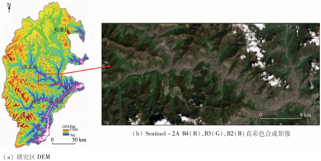
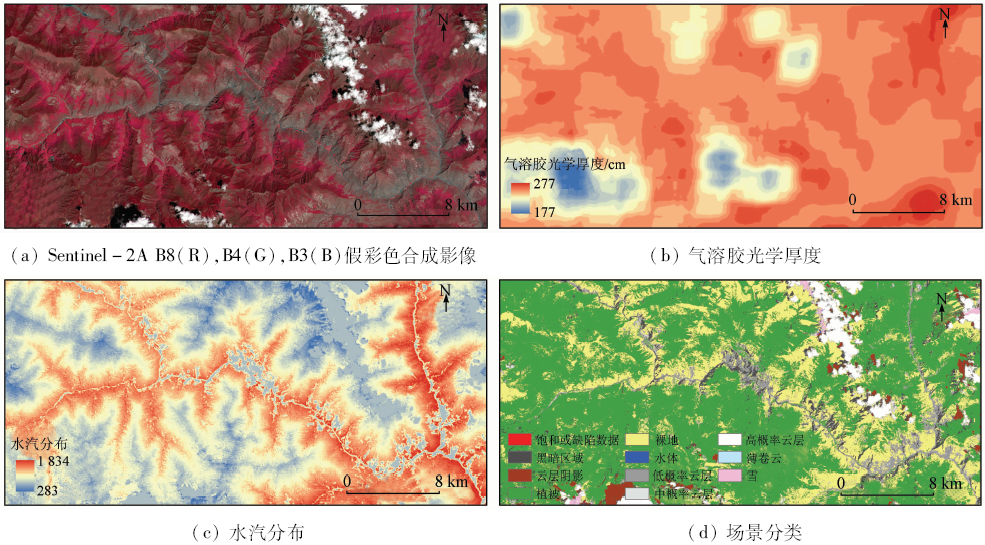
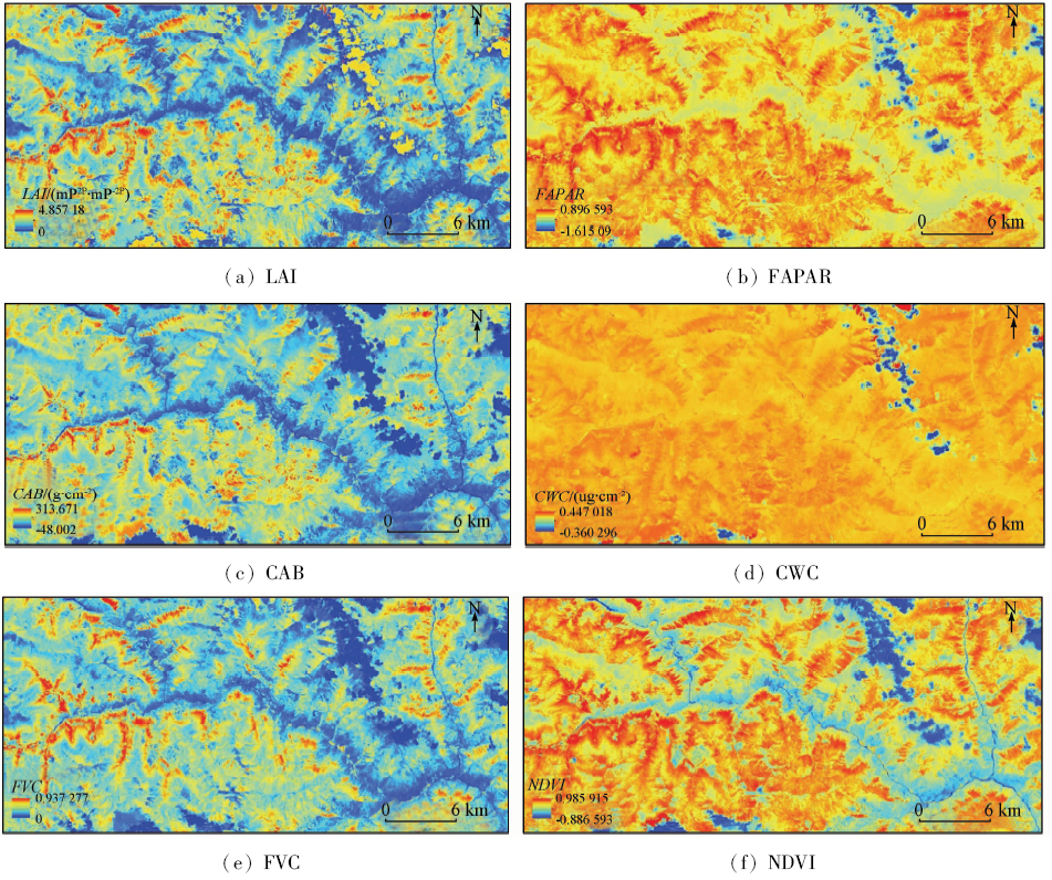
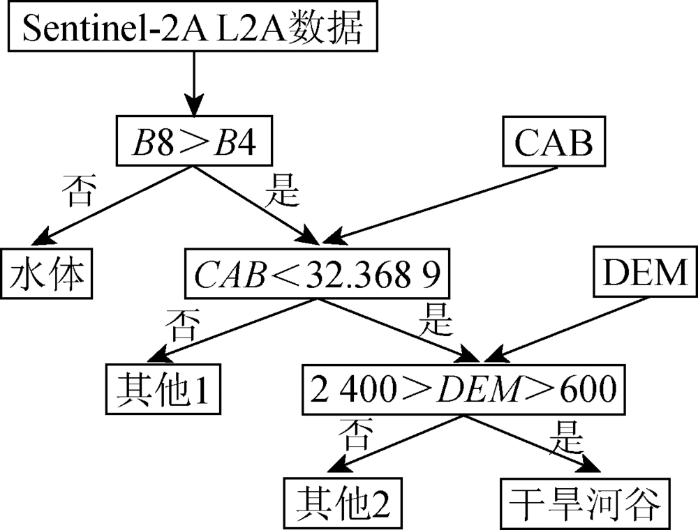
Abstract As a new optical remote sensing satellite, Sentinel-2A has become a hot spot in optical remote sensing applications because it has wide bandwidth, multi-spectrum, high spatial-temporal resolution and free sharing. In this study, we chose Heishui River basin as the study area and selected Sentinel-2A satellite data from European Space Agency. The authors obtained aerosol optical data, water vapor data, scene classification data and biomass factor data through analysis of data arguments, organization form, product grade and data format by using the sen2cor processing module of SNAP. The distribution areas of arid valley in the study area were extracted by using the vegetation ecological index data and digital elevation model, combined with the expert decision classification method with the analyses of biophysical index data. The result shows that Sentinel-2A satellite data have good quality in that they enrich the application field of remote sensing technology greatly. L2A level data have more positive application value for the monitoring and evaluation of global ecological vegetation environment change.
|
| Keywords
Sentinel-2A
vegetation biophysical index
atmospheric correction
dry valleys
European Space Agency
|
|
|
|
Issue Date: 10 September 2018
|
|
|
| [1] |
Suhet. Sentinel-2 User Handbook[M]. [s.l.]:European Space Agency, 2013: 1.
|
| [2] |
Drusch M, Del Bello U, Carlier S , et al. Sentinel-2:ESA’s optical high-resolution mission for GMES operational services[J]. Remote Sensing of Environment, 2012,120:25-36.
doi: 10.1016/j.rse.2011.11.026
url: http://linkinghub.elsevier.com/retrieve/pii/S0034425712000636
|
| [3] |
Malenovský Z, Rott H, Cihlar J , et al. Sentinels for science:Potential of Sentinel-1,-2,and -3 missions for scientific observations of ocean,cryosphere,and land[J]. Remote Sensing of Environment, 2012,120:91-101.
doi: 10.1016/j.rse.2011.09.026
url: http://linkinghub.elsevier.com/retrieve/pii/S0034425712000648
|
| [4] |
Laurent V C E, Schaepman M E, Verhoef W , et al. Bayesian object-based estimation of LAI and chlorophyll from a simulated Sentinel-2 top-of-atmosphere radiance image[J]. Remote Sensing of Environment, 2014,140:318-329.
doi: 10.1016/j.rse.2013.09.005
url: http://linkinghub.elsevier.com/retrieve/pii/S0034425713003088
|
| [5] |
Hagolle O, Huc M, Pascual D V , et al. A multi-temporal method for cloud detection,applied to FORMOSAT-2,VENμS,LANDSAT and SENTINEL-2 images[J]. Remote Sensing of Environment, 2010,114(8):1747-1755.
doi: 10.1016/j.rse.2010.03.002
url: http://linkinghub.elsevier.com/retrieve/pii/S0034425710000908
|
| [6] |
Hill M J . Vegetation index suites as indicators of vegetation state in grassland and savanna:An analysis with simulated SENTINEL 2 data for a North American transect[J]. Remote Sensing of Environment, 2013,137:94-111.
doi: 10.1016/j.rse.2013.06.004
url: http://linkinghub.elsevier.com/retrieve/pii/S0034425713001971
|
| [7] |
Verrelst J, Rivera J P, Veroustraete F , et al. Experimental Sentinel-2 LAI estimation using parametric,non-parametric and physical retrieval methods-A comparison[J]. ISPRS Journal of Photogrammetry and Remote Sensing, 2015,108:260-272.
doi: 10.1016/j.isprsjprs.2015.04.013
url: http://linkinghub.elsevier.com/retrieve/pii/S0924271615001239
|
| [8] |
Fernández-Manso A, Fernández-Manso O, Quintano C . Sentinel-2A red-edge spectral indices suitability for discriminating burn severity[J]. International Journal of Applied Earth Observation and Geoinformation, 2016,50:170-175.
doi: 10.1016/j.jag.2016.03.005
url: http://linkinghub.elsevier.com/retrieve/pii/S0303243416300368
|
| [9] |
Verrelst J, Rivera J P, Moreno J , et al. Gaussian processes uncertainty estimates in experimental Sentinel-2 LAI and leaf chlorophyll content retrieval[J]. ISPRS Journal of Photogrammetry and Remote Sensing, 2013,86:157-167.
doi: 10.1016/j.isprsjprs.2013.09.012
url: http://linkinghub.elsevier.com/retrieve/pii/S092427161300213X
|
| [10] |
Zurita-Milla R, Laurent V C E,Van Gijsel J A E .Visualizing the ill-posedness of the inversion of a canopy radiative transfer model:A case study for Sentinel-2[J]. International Journal of Applied Earth Observation and Geoinformation, 2015,43:7-18.
doi: 10.1016/j.jag.2015.02.003
url: http://linkinghub.elsevier.com/retrieve/pii/S0303243415000355
|
| [11] |
Herrmann I, Pimstein A, Karnieli A , et al. LAI assessment of wheat and potato crops by VENμS and Sentinel-2 bands[J]. Remote Sensing of Environment, 2011,115(8):2141-2151.
doi: 10.1016/j.rse.2011.04.018
url: http://linkinghub.elsevier.com/retrieve/pii/S0034425711001465
|
| [12] |
Verrelst J, Muñoz J, Alonso L , et al. Machine learning regression algorithms for biophysical parameter retrieval:Opportunities for Sentinel-2 and -3[J]. Remote Sensing of Environment, 2012,118:127-139.
doi: 10.1016/j.rse.2011.11.002
url: http://linkinghub.elsevier.com/retrieve/pii/S003442571100397X
|
| [13] |
Van Der Meer F D, Van Der Werff H M A, Van Ruitenbeek F J A . Potential of ESA’s Sentinel-2 for geological applications[J]. Remote Sensing of Environment, 2014,148:124-133.
doi: 10.1016/j.rse.2014.03.022
url: http://linkinghub.elsevier.com/retrieve/pii/S0034425714001084
|
| [14] |
Cleversa J G P W, Gitelson A A . Remote estimation of crop and grass chlorophyll and nitrogen content using red-edge bands on Sentinel-2 and -3[J]. International Journal of Applied Earth Observation and Geoinformation, 2013,23:344-351.
doi: 10.1016/j.jag.2012.10.008
url: http://linkinghub.elsevier.com/retrieve/pii/S0303243412002097
|
| [15] |
Atzberger C, Richter K . Spatially constrained inversion of radiative transfer models for improved LAI mapping from future Sentinel-2 imagery[J]. Remote Sensing of Environment, 2012,120:208-218.
doi: 10.1016/j.rse.2011.10.035
url: http://linkinghub.elsevier.com/retrieve/pii/S003442571200079X
|
| [16] |
Novelli A, Aguilar M A, Nemmaoui A , et al. Performance evaluation of object based greenhouse detection from Sentinel-2 MSI and Landsat 8 OLI data:A case study from Almería (Spain)[J]. International Journal of Applied Earth Observation and Geoinformation, 2016,52:403-411.
doi: 10.1016/j.jag.2016.07.011
url: https://linkinghub.elsevier.com/retrieve/pii/S0303243416301180
|
| [17] |
ESA. Sentinel-2:ESA’s Optical High-Resolution Mission for GMES Operational Services[M]. Leiden,the Netherlands:European Space Agency, 2012: 3.
|
| [18] |
Müller-Wilm U. Sen2Cor 2.2.1 - Software Release Note[M]. [s.l.]:European Space Agency, 2016.
|
| [19] |
Louis J . Sentinel 2 MSI-Level 2A Product Definition[M]. European Space Agency, 2016: 4.
|
| [20] |
Louis J . Sentinel 2 MSI-Level 2A Product Format Specifications Technical Note[R].S2PAD-VEGA-TN-PFS-0001,Darmstadt, Germany:European Space Agency, 2016: 4.
|
| [21] |
Müller-Wilm U . Sentinel-2 MSI-Level-2A Prototype Processor Installation and User Manual[R].S2PAD-VEGA-SUM-0001,Darmstadt, Germany:European Space Agency, 2016: 4.
|
| [22] |
Müller-Wilm U . Sentinel-2 MSI-Level-2A Prototype Processor Installation and User Manual[R].S2PAD-VEGA-SUM-0001,Darmstadt, Germany:European Space Agency, 2016: 4.
|
| [23] |
韩忻忆, 颉耀文 . 基于决策树的干旱区湿地信息自动提取——以疏勒河流域为例[J]. 遥感技术与应用, 2015,30(6):1146-1152.
doi: 10.11873/j.issn.1004-0323.2015.6.1146
|
| [23] |
Han X Y, Xie Y W . The automatic extraction of wetland information in arid zone based on decision tree algorithm:A case study in the Shule River basin[J]. Remote Sensing Technology and Application, 2015,30(6):1146-1152.
|
| [24] |
娄雪婷, 曾源, 吴炳方 . 森林地上生物量遥感估测研究进展[J]. 国土资源遥感, 2011,23(1):1-8.doi: 10.6046/gtzyyg.2011.01.01.
doi: 10.6046/gtzyyg.2011.01.01
url: 年度引用
|
| [24] |
Lou X T, Zeng Y, Wu B F . Advances in the estimation of above-ground biomass of forest using remote sensing[J]. Remote Sensing for Land and Resources, 2011,23(1):1-8.doi: 10.6046/gtzyyg.2011.01.01.
|
| [25] |
杨斌, 詹金凤, 李茂娇 . 岷江上游流域环境脆弱性评价[J]. 国土资源遥感, 2014,26(4):138-144.doi: 10.6046/gtzyyg.2014.04.22.
doi: 10.6046/gtzyyg.2014.04.22
|
| [25] |
Yang B, Zhan J F, Li M J . Evaluation of environmental vulnerability in the upper reaches of the Minjiang River[J]. Remote Sensing for Land and Resources, 2014,26(4):138-144.doi: 10.6046/gtzyyg.2014.04.22.
|
| [26] |
包维楷, 庞学勇, 李芳兰 , 等. 干旱河谷生态恢复与持续管理的科学基础[M]. 北京: 科学出版社, 2012.
|
| [26] |
Bao W K, Pang X Y, Li F L , et al. The Scientific Basis for Ecological Restoration and Sustainable Management in Arid Valley[M]. Beijing: Science Press, 2012.
|
| [27] |
杨兆平, 常禹, 杨孟 , 等. 岷江上游干旱河谷景观边界动态及其影响域[J]. 应用生态学报, 2007,18(9):1972-1976.
doi:
|
| [27] |
Yang Z P, Chang Y, Yang M , et al. Dynamics and influence width of dry valley landscape boundary in upper reaches of Minjiang River[J]. Chinese Journal of Applied Ecology, 2007,18(9):1972-1976.
|
|
Viewed |
|
|
|
Full text
|
|
|
|
|
Abstract
|
|
|
|
|
Cited |
|
|
|
|
| |
Shared |
|
|
|
|
| |
Discussed |
|
|
|
|
 2018,
Vol. 30
2018,
Vol. 30