|
|
 |
|

|
|
|
Deformation monitoring along the landscape corridor of Zhangjiakou Ming Great Wall using Sentinel-1 SBAS-InSAR approach |
HE Haiying1,2( ), CHEN Caifen3(), CHEN Fulong1, TANG Panpan1 ), CHEN Caifen3(), CHEN Fulong1, TANG Panpan1 |
1. Aerospace Information Research Institute, Chinese Academy of Sciences, Beijing 100094, China
2. University of Chinese Academy of Sciences, Beijing 101408, China
3. Beijing Jucai Zhenbang Enterprise Management Consultant Co., Ltd., Beijing 100038, China |
|
|
|
|
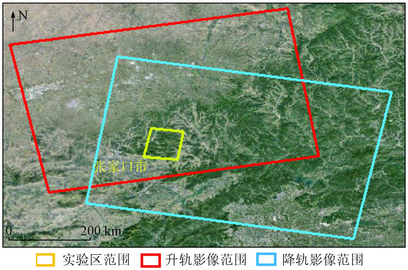
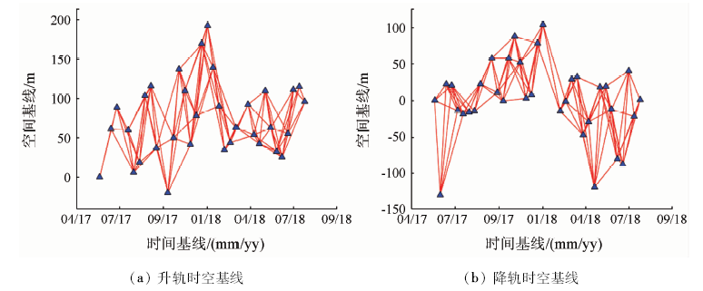
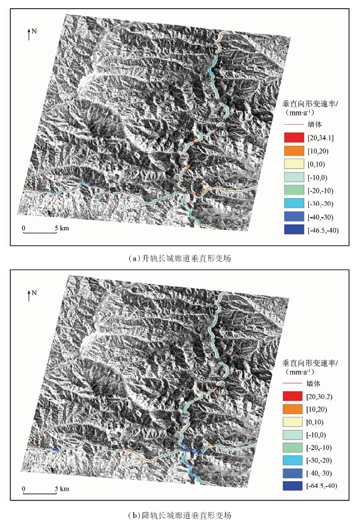
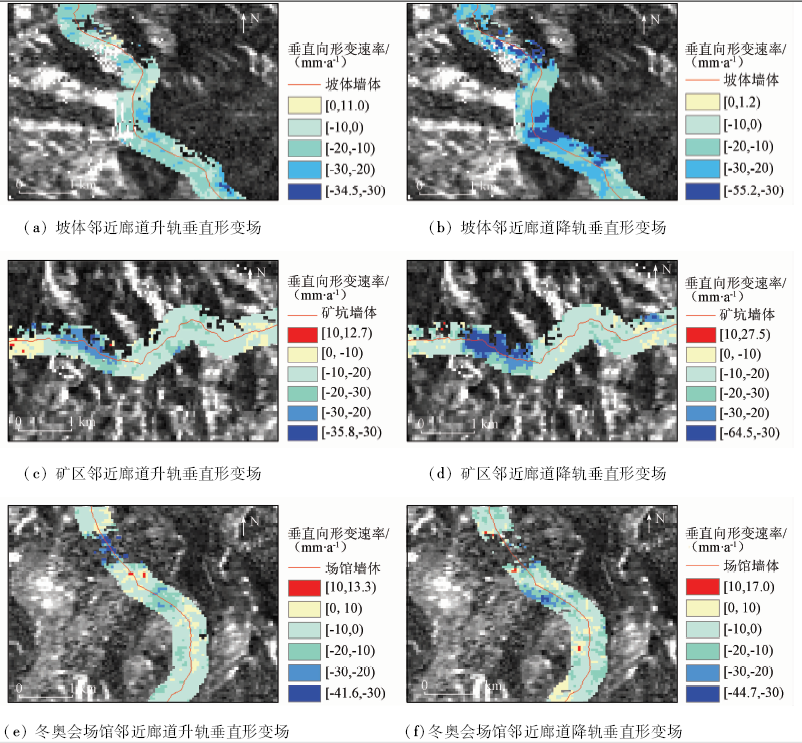
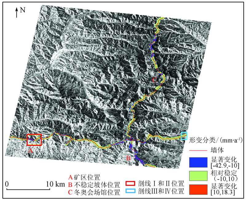
Abstract The cultural landscape of the Zhangjiakou Ming Great Wall is susceptible to surface deformation, making the systematic conservation of cultural landscape in this corridor quite challenging. In order to fix the methodology and application gaps of Great Wall monitoring (large-scale linear heritage) systematically, the authors applied the SBAS-InSAR technology to the time-series deformation surveillance in this pilot case study. In the procedures of InSAR data processing, an external weather model (GACOS) was firstly used to reduce the atmospheric artifacts on interferograms; moreover, a 40 m Gauss and the Goldstein filters were sequentially applied for the phase noise suppression relevant to the natural landscape. In total 67 Sentinel-1 SAR images including 33 ascending and 34 descending data acquired from May 2017 to July 2018 were collected for the line of sight (LOS) deformation calculation using the SBAS-InSAR approach. The derived deformation rates were then projected onto vertical direction for the further analysis. Afterwards, motion rate profiles of ascending and descending datasets from a typical mountain and a flat area were selected for cross-validation, resulting in the maximum and averaged root mean square errors of 9.3 mm/a and 4.0 mm/a, respectively. With considering the significance level, the result demonstrates that 79.5% of the Great Wall corridor (85.1 km totally observed) is relatively stable (with deformation rates in the range of -10 mm/a to 10 mm/a) while remaining 20.5 % shows significant motions (the maximum subsidence rate up to -64.5 mm/a) using the 10 mm/a as the threshold. This pilot study implied the applicability of the applied SBAS-InSAR approach to the synoptic deformation monitoring of large-scale linear heritage sites.
|
| Keywords
the Great Wall
SBAS-InSAR
ascending and descending
atmospheric correction
|
|
|
|
Corresponding Authors:
CHEN Caifen
E-mail: hehy@radi.ac.cn;chencaifenhome@sohu.com
|
|
Issue Date: 18 March 2021
|
|
|
| [1] |
王晓轩. 张家口——中国历代长城博物馆(中国城市·张家口专版(二))[EB/OL].(2006-09-19)[2018-11-18]. http://paper.people.com.cn/rmrbhwb/html/200609/19/content_11299006.html.
url: http://paper.people.com.cn/rmrbhwb/html/200609/19/content_11299006.html
|
| [1] |
Wang X X. Zhangjiakou-Great Wall Museum of Chinese History (China City·Zhangjiakou Special Edition(2))[EB/OL].(2006-09-19)[2018-11-18]. http://paper.people.com.cn/rmrbhwb/html/200609/19/content_11299006.html.
url: http://paper.people.com.cn/rmrbhwb/html/200609/19/content_11299006.html
|
| [2] |
Gabriel A K, Goldstein R M, Zebker H A. Mapping small elevation changes over large areas-differential Radar interferometry[J]. Journal of Geophysical Research Solid Earth, 1989,94(B7):9183-9191.
|
| [3] |
朱建军, 李志伟, 胡俊. InSAR变形监测方法与研究进展[J]. 测绘学报, 2017,46(10):1717-1733.
|
| [3] |
Zhu J J, Li Z W, Hu J. Research progress and methods of InSAR for deformation monitoring[J]. Acta Geodaetica et Cartographica Sinica, 2017,46(10):1717-1733.
|
| [4] |
Berardino P, Fornaro G, Lanari R, et al. A new algorithm for surface deformation monitoring based on small baseline differential SAR interferograms[J]. IEEE Transactions on Geoscience and Remote Sensing, 2003,40(11):2375-2383.
|
| [5] |
Usai S. A least squares database approach for SAR interferometric data[J]. IEEE Transactions on Geoscience and Remote Sensing, 2003,41(4):753-760.
|
| [6] |
许文斌, 李志伟, 丁晓利, 等. 利用InSAR短基线技术估计洛杉矶地区的地表时序形变和含水层参数[J]. 地球物理学报, 2012,55(2):452-461.
|
| [6] |
Xu W B, Li Z W, Ding X L, et al. Application of small baseline subsets D-InSAR technology to estimate the time series land deformation and aquifer storage coefficients of Los Angeles area[J]. Chinese Journal of Geophysics, 2012,55(2):452-461.
|
| [7] |
张永红, 吴宏安, 康永辉. 京津冀地区1992—2014年三阶段地面沉降InSAR监测[J]. 测绘学报, 2016,45(9):1050-1058.
|
| [7] |
Zhang Y H, Wu H A, Kang Y H. Ground subsidence over Beijing-Tianjin-Hebei region during three periods of 1992 to 2014 monitored by interferometric SAR[J]. Acta Geodaetica et Cartographica Sinica, 2016,45(9):1050-1058.
|
| [8] |
周吕, 郭际明, 李昕, 等. 基于SBAS-InSAR的北京地区地表沉降监测与分析[J]. 大地测量与地球动力学, 2016,36(9):793-797.
|
| [8] |
Zhou L, Guo J M, Li X, et al. Monitoring and analyzing on ground settlement in Beijing area based on SBAS-InSAR[J]. Journal of Geodesy and Geodynamics, 2016,36(9):793-797.
|
| [9] |
孙晓鹏, 鲁小丫, 文学虎, 等. 基于SBAS-InSAR的成都平原地面沉降监测[J]. 国土资源遥感, 2016,28(3):123-129.doi: 10.6046/gtzyyg.2016.03.20.
|
| [9] |
Sun X P, Lu X Y, Wen X H, et al. Monitoring of ground subsidence in Chengdu Plain using SBAS-InSAR[J]. Remote Sensing for Land and Resources, 2016,28(3):123-129.doi: 10.6046/gtzyyg.2016.03.20.
|
| [10] |
吴文豪. 哨兵雷达卫星TOPS模式干涉处理研究[D]. 武汉:武汉大学, 2016.
|
| [10] |
Wu W H. TOPS interferometry with Sentinel-1[D]. Wuhan:Wuhan University, 2016.
|
| [11] |
陈富龙, 林珲, 程世来. 星载雷达干涉测量及时间序列分析的原理、方法与应用[M]. 北京: 科学出版社, 2013: 41-68.
|
| [11] |
Chen F L, Lin H, Cheng S L. Principles,methods and applications of spaceborne Radar interferometry and time series analysis[M]. Beijing: Science Press, 2013: 41-68.
|
| [12] |
胡俊. 基于现代测量平差的InSAR三维形变估计理论与方法[D]. 长沙:中南大学, 2013.
|
| [12] |
Hu J. Theory and method of estimating three-dimensional displacement with InSAR based on the modern surveying adjustment[D]. Changsha:Central South University, 2013.
|
| [13] |
Fialko Y, Simons M, Agnew D. The complete (3-D) surface displacement field in the epicentral area of the 1999 MW7.1 Hector Mine Earthquake,California,from space geodetic observations[J]. Geophysical Research Letters, 2001,28(16):3063-3066.
|
| [14] |
Hu J, Li Z W, Zhu J J, et al. Inferring three-dimensional surface displacement field by combining SAR interferometric phase and amplitude information of ascending and descending orbits[J]. Science in China Series D(Earth Sciences), 2010,53(4):550-560.
|
| [15] |
张晓博. 基于高分辨率SAR影像的城市二维时序形变建模与应用[D]. 北京:中国矿业大学(北京), 2018.
|
| [15] |
Zhang X B. Modeling and application of the 2D time series deformation monitoring in urban area using high resolution SAR images[D]. Beijing:China University of Mining and Technology(Beijing), 2018.
|
| [16] |
崔喜爱, 曾琪明, 童庆禧, 等. 重轨星载InSAR测量中的大气校正方法综述[J]. 遥感技术与应用, 2014,29(1):9-17.
|
| [16] |
Cui X A, Zeng Q M, Tong Q X, et al. Overview of the atmospheric correction methods in repeat-pass InSAR measurements[J]. Remote Sensing Technology and Application, 2014,29(1):9-17.
|
| [17] |
孙建霖, 杨忠杰, 马金辉. 基于大气数据的时序InSAR大气延迟误差校正方法比较[J]. 科技创新与应用, 2019(11):23-26,30.
|
| [17] |
Sun J L, Yang Z J, Ma J H. Comparison of correction methods of time series InSAR atmospheric delay error based on atmospheric data[J]. Technology Innovation and Application, 2019(11):23-26,30
|
| [18] |
Yu C, Penna N T, Li Z. Generation of real-time mode high-resolution water vapor fields from GPS observations[J]. Journal of Geophysical Research(Atmospheres), 2017,122(3):2008-2025.
|
| [19] |
Yu C, Li Z, Penna N T. Interferometric synthetic aperture Radar atmospheric correction using a GPS-based iterative tropospheric decomposition model[J]. Remote Sensing of Environment, 2017,204:109-121.
doi: 10.1016/j.rse.2017.10.038
url: https://linkinghub.elsevier.com/retrieve/pii/S0034425717305011
|
| [20] |
王琴, 陈蜜, 刘书军, 等. 利用升降轨道SAR数据获取DEM的试验研究[J]. 测绘通报, 2015(6):39-43.
doi: 10.13474/j.cnki.11-2246.2015.0174
url: http://tb.sinomaps.com:8081/Jwk_chtb//CN/abstract/abstract1435.shtml
|
| [20] |
Wang Q, Chen M, Liu S J, et al. DEM acquisition study using raise-orbit and lower-orbit SAR data[J]. Bulletin of Surveying and Mapping, 2015(6):39-43.
|
|
Viewed |
|
|
|
Full text
|
|
|
|
|
Abstract
|
|
|
|
|
Cited |
|
|
|
|
| |
Shared |
|
|
|
|
| |
Discussed |
|
|
|
|
 2021,
Vol. 33
2021,
Vol. 33