|
|
 |
|

|
|
|
A study of the variation and driving factors of the water area of the terminal lake of inland river: A case study of Taitema Lake region |
HUO Tianci1( ), YAN Wei2(), MA Xiaofei1,3 ), YAN Wei2(), MA Xiaofei1,3 |
1. Xinjiang Institute of Ecology and Geography, Chinese Academy of Sciences, Urumqi 830011, China
2. School of Geographic Sciences, Xinyang Normal University, Xinyang 464000, China
3. University of Chinese Academy of Sciences, Beijing 100049, China |
|
|
|
|
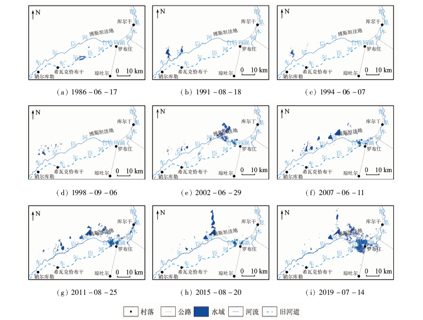
Abstract Terminal lake, which is an important part of oasis ecosystem in the lower reaches of inland river in arid region, has the functions of water conservation, wind prevention and sand fixation. However, for nearly half a century, the terminal lake of inland river has been shrinking under the influence of climate change and human activities, and the ecological environment around the lake has been deteriorating, which has seriously threatened the regional social development. In order to explore the changes and driving factors of the water area of the terminal lake in the arid region, this paper took the Taitema Lake region as an example, selected nine Landsat TM/OLI remote sensing images from 1986 to 2019, and extracted and analyzed the change characteristics and driving factors of the water area of the Taitema Lake region. The results showed that the water area of the study region increased by 163.93 km 2 in the past 34 years. In terms of spatial distribution, water area of the study region was scattered around the lower reaches of Qarqan River before the 21st century, and mainly distributed around Taitema Lake since the 21st century. The center of gravity of the water area in the study region experienced four processes: rapid westward shift in the late 1980s, slow eastward shift in the 1990s, rapid eastward shift in the late 1990s to early 2000s, and eastward shift in the fluctuation since the 21st century. Taking the water transport to the lower reaches of Tarim River as the boundary, the water area before water transport is mainly affected by the comprehensive effects of regional natural factors, with precipitation as the main driving factor (r 2=0.825). After water transport, the water transport process with human intervention is the leading factor (r 2=0.977) affecting the change of water area in the study region. With the continuous water transfer to the downstream of Tarim River, the ecological environment of Taitema Lake has been restored continuously. In order to prevent the lake from overflowing and spilling eastward into Lop Nor, it is necessary to explore the maximum water capacity of Taitema Lake so as to reasonably control the water transfer.
|
| Keywords
terminal lake
Taitema Lake
water area change
ecological water transport
remote sensing
|
|
|
|
Corresponding Authors:
YAN Wei
E-mail: huotianci2@163.com;jw@xynu.edu.cn
|
|
Issue Date: 09 October 2020
|
|
|
| [1] |
陈曦, 包安明, 王新平, 等. 塔里木河近期综合治理工程生态成效评估[J]. 中国科学院院刊, 2017,32(1):20-28.
|
| [1] |
Chen X, Bao A M, Wang X P, et al. Ecological effect evaluation of comprehensive control project in Tarim River basin[J]. Bulletin of Chinese Academy of Sciences, 2017,32(1):20-28.
|
| [2] |
杨鹏年, 邓铭江, 李霞, 等. 塔里木河下游间歇输水下地下水响应宽度——以塔里木河下游英苏断面为例[J].干旱区研究, 2008(3):331-335.
url: http://d.wanfangdata.com.cn/Periodical_ghqyj200803004.aspx
|
| [2] |
Yang P N, Deng M J, Li X, et al. Respond width of groundwater level after conveying stream water to the lower reaches of the Tarim River,Xinjiang:A case study along the Yengisu section in the lower reaches of Tarim River[J].Arid Zone Research 2008(3):331-335.
|
| [3] |
徐海量, 樊自立, 杨鹏年, 等. 塔里木河近期治理评估及对编制流域综合规划建议[J]. 干旱区地理, 2015,38(4):645-651.
url: http://alg.xjegi.com//CN/abstract/abstract8874.shtml
|
| [3] |
Xu H L, Fan Z L, Yang P N, et al. Short term evaluation and advice of compiling planning for the Tarim River basin in future[J]. Arid Land Geography, 2015,38(4):645-651.
url: http://alg.xjegi.com//CN/abstract/abstract8874.shtml
|
| [4] |
杨戈, 郭永平. 塔里木河下游末端实施生态输水后植被变化与展望[J].中国沙漠, 2004(2):55-60.
|
| [4] |
Yang Y, Guo Y P. The change and prospect of vegetation in the end of the lower reaches of Tarim River after ecological water delivering[J].Journal of Desert Research 2004(2):55-60.
|
| [5] |
李丽君, 张小清, 陈长清, 等. 近20 a塔里木河下游输水对生态环境的影响[J]. 干旱区地理, 2018,41(2):238-247.
|
| [5] |
Li L J, Zhang X Q, Chen C Q, et al. Ecological effects of water conveyance on the lower reaches of Tarim River in recent twenty years[J]. Arid Land Geography, 2018,41(2):238-247.
|
| [6] |
王雅梅, 张青青, 徐海量, 等. 生态输水前后台特玛湖植物多样性变化特征[J]. 干旱区研究, 2019,36(5):1186-1193.
|
| [6] |
Wang Y M, Zhang Q Q, Xu H L, et al. Change of plant diversity in the Taitema Lake area before and after implementing the ecological water conveyance[J]. Arid Zone Research, 2019,36(5):1186-1193.
|
| [7] |
钟家骅. 塔里木河流域植被生态变化研究[D]. 西安:长安大学, 2018.
|
| [7] |
Zhong J H. The changes of the vegetation ecosystems in Tarim River Basin[D]. Xi’an:Chang’an University, 2018.
|
| [8] |
郭继凯. 塔里木河流域植被覆盖对气候变化和人类活动的响应[D]. 北京:北京林业大学, 2016.
|
| [8] |
Guo J K. Responses of vegetation coverage to climate change and human activities in the Tarim River basin[D]. Beijing:Beijing Forestry University, 2016.
|
| [9] |
黄粤, 包安明, 王士飞, 等. 间歇性输水影响下的2001—2011年塔里木河下游生态环境变化[J]. 地理学报, 2013,68(9):1251-1262.
doi: 10.11821/dlxb201309008
url: http://www.geog.com.cn/CN/abstract/abstract21814.shtml
|
| [9] |
Huang Y, Bao A M, Wang S F, et al. Eco-environmental change in the lower Tarim River under the influence of intermittent water transport[J]. Acta Geographica Sinica, 2013,68(9):1251-1262.
doi: 10.11821/dlxb201309008
url: http://www.geog.com.cn/CN/abstract/abstract21814.shtml
|
| [10] |
阿布都米吉提·阿布力克木, 阿里木江·卡斯木, 艾里西尔·库尔班, 等. 近40年台特玛—康拉克湖泊群水域变化遥感监测[J]. 湖泊科学, 2014,26(1):46-54.
|
| [10] |
Ablekim A, Kasimu A, Kurban A, et al. Monitoring the water area changes in Tetima-Kanglayka lakes region over the past four decades by remotely sensed data[J]. Journal of Lake Sciences, 2014,26(1):46-54.
doi: 10.18307/2014.0106
url: <![CDATA[http://www.jlakes.org/ch/reader/view_abstract.aspx?doi=10.18307/2014.0106]]>
|
| [11] |
樊自立, 徐海量, 张鹏, 等. 新疆车尔臣河及其水资源利用研究[J]. 干旱区研究, 2014,31(1):20-26.
url: http://azr.xjegi.com/CN/abstract/abstract8878.shtml
|
| [11] |
Fan Z L, Xu H L, Zhang P, et al. The Qarqan River in Xinjiang and its water resources utilization[J]. Arid Zone Research, 2014,31(1):20-26.
|
| [12] |
王姝怡. 近30年台特玛湖地区生态环境演变及影响因素研究[D]. 石家庄:河北师范大学, 2019.
|
| [12] |
Wang S Y. Study on the evolution and driving factors of ecological environment in the Taitema Lake area in recent 30 years[D]. Shijiazhuang:Hebei Normal University, 2019.
|
| [13] |
McFeeters S K. The use of the normalized difference water index (NDWI) in the delineation of open water features. International Journal of Remote Sensing, 1996,17(7):1425-1432.
|
| [14] |
徐涵秋. 利用改进的归一化差异水体指数(MNDWI)提取水体信息的研究[J].遥感学报, 2005(5):589-595.
|
| [14] |
Xu H Q. A study on information extraction of water body with the modified normalized difference water index (MNDWI)[J].Journal of Remote Sensing 2005(5):589-595.
|
| [15] |
吴成永, 陈克龙, 曹广超, 等. 近30年来青海省风蚀气候侵蚀力时空差异及驱动力分析[J]. 地理研究, 2018,37(4):717-730.
|
| [15] |
Wu C Y, Chen K L, Cao G C, et al. The spatial and temporal differences and driving forces of wind erosion climatic erosivity in Qinghai Province from 1984 to 2013[J]. Geographical Research, 2018,37(4):717-730.
|
| [16] |
胡尔西别克·孜依纳力, 毋兆鹏, 哈孜亚·包浪提将. 新疆玛纳斯湖近40年间时空变化图谱及其驱动机制[J]. 国土资源遥感, 2018,30(1):217-223.doi: 10.6046/gtzyyg.2018.01.30.
|
| [16] |
Ziyinali H, Wu Z P, Baolangtijiang K. Lake changes in spatial evolution and driving force for the water area change of the Manas lake in Xinjiang in the past forty years[J]. Remote Sensing for Land and Resources, 2018,30(1):217-223.doi: 10.6046/gtzyyg.2018.01.30.
|
| [17] |
黄娉婷, 张晓平. 大都市区工业重心时空变动轨迹分析:以天津市为例[J]. 经济地理, 2012,32(3):89-95.
|
| [17] |
Huang P T, Zhang X P. Analysis of temporal and spatial movement of the gravity center of city industry:A case study of Tianjin[J]. Economic Geography, 2012,32(3):89-95.
|
| [18] |
邓铭江, 杨鹏年, 周海鹰, 等. 塔里木河下游水量转化特征及其生态输水策略[J]. 干旱区研究, 2017,34(4):717-726.
|
| [18] |
Deng M J, Yang P N, Zhou H Y, et al. Water conversion and strategy of ecological water conveyance in the lower reaches of the Tarim River[J]. Arid Zone Research, 2017,34(4):717-726.
|
| [19] |
朱长明, 李均力, 沈占锋, 等. 塔里木河下游生态环境变化时序监测与对比分析[J]. 地球信息科学学报, 2019,21(3):437-444.
|
| [19] |
Zhu C M, Li J L, Shen Z F, et al. Time series monitoring and comparative analysis on eco-environment change in the lower reaches of the Tarim River[J]. Journal of Geo-Information Science, 2019,21(3):437-444.
|
| [20] |
冉津江, 季明霞, 黄建平, 等. 中国北方干旱区和半干旱区近60年气候变化特征及成因分析[J]. 兰州大学学报(自然科学版), 2014,50(1):46-53.
|
| [20] |
Ran J J, Ji M X, Huang J P, et al. Characteristics and factors of climate change in arid and semi-arid areas over northern China in the recent 60 years[J]. Journal of Lanzhou University(Natural Sciences), 2014,50(1):46-53.
|
| [21] |
胡实, 莫兴国, 林忠辉. 未来气候情景下我国北方地区干旱时空变化趋势[J]. 干旱区地理, 2015,38(2):239-248.
|
| [21] |
Hu S, Mo X G, Lin Z H, et al. Projections of spatial-temporal variation of drought in north China[J]. Arid Land Geography, 2015,38(2):239-248.
|
| [22] |
李丽, 曾庆伟, 周会珍, 等. 新疆车尔臣河绿色走廊河湖湿地变化及原因分析[J]. 干旱区研究, 2012,29(2):233-237.
|
| [22] |
Li L, Zeng Q W, Zhou H Z, et al. Change and causes of the river-lake marshes along the green corridor at the lower reaches of the Qarqan River[J]. Arid Zone Research, 2012,29(2):233-237.
|
| [23] |
樊自立, 徐海量, 傅荩仪, 等. 台特玛湖湿地保护研究[J]. 第四纪研究, 2013,33(3):594-602.
|
| [23] |
Fan Z L, Xu H L, Fu J Y, et al. Study on protection of wet land of Taitema Lake[J]. Quaternary Sciences, 2013,33(3):594-602.
|
|
Viewed |
|
|
|
Full text
|
|
|
|
|
Abstract
|
|
|
|
|
Cited |
|
|
|
|
| |
Shared |
|
|
|
|
| |
Discussed |
|
|
|
|
 2020,
Vol. 32
2020,
Vol. 32