|
|
 |
|

|
|
|
Hyperspectral inversion of macro element content in loess based on the profile of Zaoshugou Village, Mangshan Mountain, Zhengzhou City |
LI Shuangquan1( ), MA Yufeng1(), LIU Xun2, LI Changchun2, DU Jun1 ), MA Yufeng1(), LIU Xun2, LI Changchun2, DU Jun1 |
1. Institute of geography, Henan Academy of Sciences, Zhengzhou 450052, China
2. Henan Polytechnic University, Jiaozuo 454000, China |
|
|
|
|
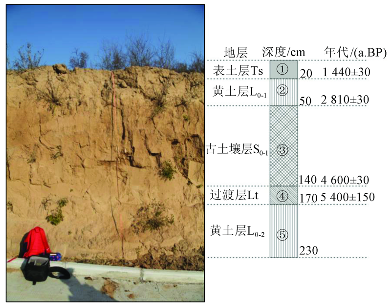
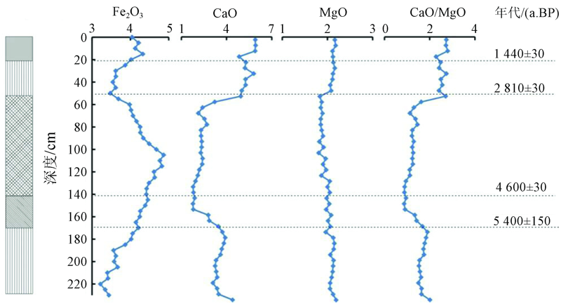
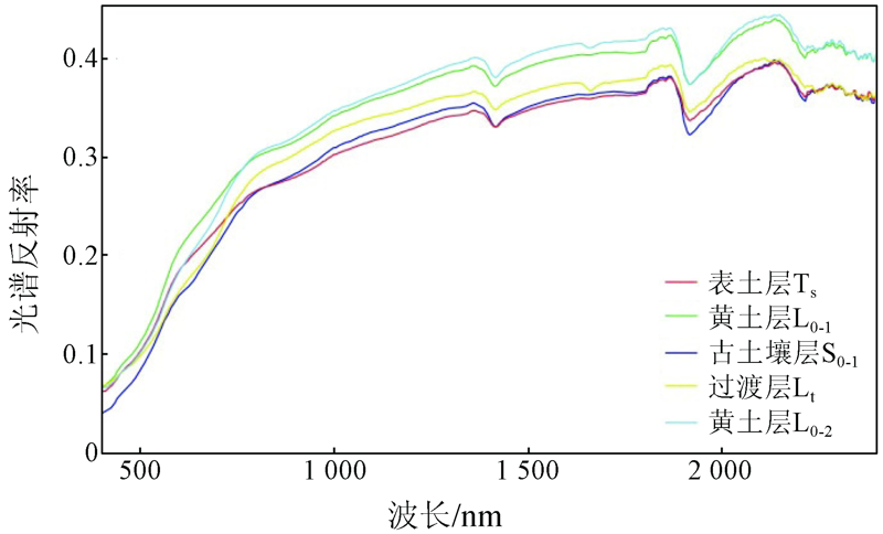
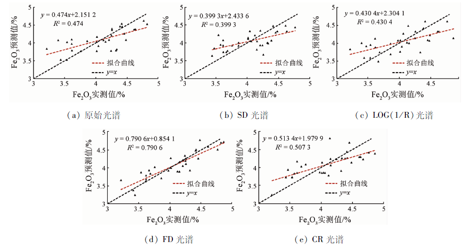
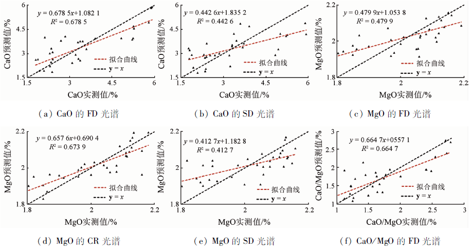
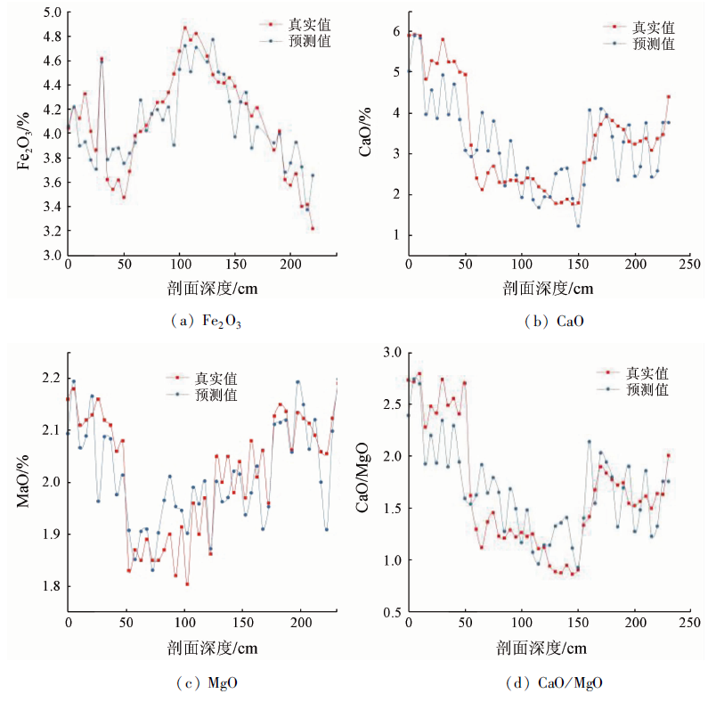
Abstract The occurrence and development themselves of loess have recorded abundant historical information, and the macro element content of loess can accurately reflect the environmental evolution. Hyperspectral remote sensing technology enjoys the advantages of being multi-band, continuous, and high-resolution. Therefore, it can be used to detect subtle differences in soil attributes and thus provide technical support for the fast and effective acquisition of basic loess information. In this paper, the loess profile of Zaoshugou Village, Zhengzhou City is studied. Combining the hyperspectral technology, the correlation between the spectral data and the macro elements of the loess was analyzed according to smoothed original spectra, first-order differential (FD), second-order differential (SD), de-envelope (CR), and reciprocal logarithm (Log(1/R). A partial least square regression (PLSR) model was established using the wave band with a larger correlation coefficient R as the characteristic band. The main conclusions are as follows. The variations in Ga, Fe, and Mg elements in the loess profile indicate that the study area has experienced a cold dry - warm wet - cold dry climate cycle since the Middle Holocene about 5400 aBP. The reflectance spectra of the loess in different stratigraphic units show the characteristics with similar trends. However, their spectral reflectance is in the order of L0-2>L0-1>Lt>S0-1>TS. According to the method of partial least squares, the optimal inversion models of Fe2O3, CaO, and CaO/MgO are the PLSR model with FD spectral transformation as the independent variable, while the best inversion model of MgO is the PLSR model with CR spectral transformation as the independent variable. The optimal inversion model of Fe2O3, CaO, and CaO/MgO can effectively distinguish different climate zones and indicate palaeoclimate cycle changes in the region where the study area falls. The optimal inversion model of MgO can better indicate the palaeoclimate evolution law of the region where the study area falls and thus has a certain reference value.
|
| Keywords
loess
hyper-spectral
macro element
partial least squares method
|
|
|
|
Corresponding Authors:
MA Yufeng
E-mail: lishuangquan@mail.bnu.edu.cn;mayufeng@mail.bnu.edu.cn
|
|
Issue Date: 24 September 2021
|
|
|
| [1] |
尹爱华, 陈翠蜂, 石敢. 中国黄土研究的新进展[J]. 经济研究导刊, 2010, 76(2):248-250.
|
| [1] |
Yin A H, Chen C F, Shi G. New progress in loess studies in China[J]. Economic Research Guide, 2010, 76(2):248-250.
|
| [2] |
刘东生. 黄土与环境[M]. 北京: 科学出版社, 1985.
|
| [2] |
Liu D S. Loess and environment[M]. Beijing: Science Press, 1985.
|
| [3] |
Lillesand T M, Kiefer R W. Remote sensing and image interpretation (3rd Edition)[M]. NewYork:John Wiley&Sons, 1994, 75.
|
| [4] |
丁式江, 陈颖民. 海南省(岛)国土环境资源遥感应用研究[M]. 北京: 地质出版社 2007.
|
| [4] |
Ding S J, Chen Y M. Remote sensing application of land,environment and resources in Hainan Province[M]. Beijing: Geological Publishing House, 2007.
|
| [5] |
彭杰, 张杨珠, 周清, 等. 湖南省几种主要类型土壤反射光谱的剖面变化特性[J]. 土壤通报, 2006, 37(2):236-240.
|
| [5] |
Peng J, Zhang Y Z, Zhou Q, et al. Reflecting spectral changes in the depth profile of Major in Hunan Provience[J]. Chinese Journal of Soil Science, 2006, 37(2):236-240.
|
| [6] |
黄应丰, 刘腾辉. 华南主要土壤类型的光谱特性与土壤分类[J]. 土壤学报, 1995, 32(1):58-68.
|
| [6] |
Huang Y F, Liu T H. Spectral characteristics of main types of soils in southern China and soil classification[J]. Acta Pedologica Sinica, 1995, 32(1):58-68.
|
| [7] |
刘东生, 孙继敏, 吴文祥. 中国黄土研究的历史、现状和未来——一次事实与股市相结合的讨论[J]. 第四纪研究, 2001, 21(3):185-207.
|
| [7] |
Liu D S, Sun J M, Wu W X. Past,present and future of the Chinese Loess Research:A discussion on the reality of facts and myth[J]. Quaternary Sciences, 2001, 21(3):185-207.
|
| [8] |
Yang S L, Ding F, Ding Z L. Pleistocene chemical weathering history of Asian arid and semi-arid regions recorded inloess deposits of China and Tajikistan[J]. Geochimica et Cosmochimica Acta, 2006, 70(7):1695-1709.
doi: 10.1016/j.gca.2005.12.012
url: https://linkinghub.elsevier.com/retrieve/pii/S0016703705009658
|
| [9] |
叶青超, 陆中陈, 杨毅芬. 黄河下游河流地貌[M]. 北京: 科学出版社, 1990.
|
| [9] |
Ye Q C, Lu Z C, Yang Y F. Fluvial landscape of the lower Yellow River[M]. Beijing: Science Press, 1990.
|
| [10] |
王德甫, 王超, 王朝栋, 等. 禹荥泽古黄河的一块天然滞洪区[J]. 湖泊科学, 2012, 24(2):320-326.
|
| [10] |
Wang D F, Wang C, Wang C D, et al. Lake Yuxingze,a natural flood detention area of the Yellow River in ancient time[J]. Journal of Lake Sciences, 2012, 24(2):320-326.
doi: 10.18307/2012.0223
url: http://www.jlakes.org/ch/reader/view_abstract.aspx?doi=10.18307/2012.0223
|
| [11] |
于革. 郑州地区湖泊水系沉积与环境演化研究[M]. 北京: 科学出版社, 2016.
|
| [11] |
Yu G. Sedimentology of lake-river systems and environmental evolutions in Zhengzhou Regions[M]. Beijing: Science Press, 2016.
|
| [12] |
张华. 大别山北麓罗山黄土古土壤古环境信息研究[D]. 合肥:合肥工业大学, 2012.
|
| [12] |
Zhang H. Study on Paleoenvironment Information of Luoshan Loess in the North of Dabie Mountain[D]. Hefei:Hefei University of Technology, 2012.
|
| [13] |
杨守业, 李从先, 李徐生, 等. 长江下游下蜀黄土化学风化的地球化学研究[J]. 地球化学, 30(4):402-406.
|
| [13] |
Yang S Y, Li C X, Li X S, et al. Geochimical records of chemical weathering of the Xiashu Loess in the lower reaches of the Changjiang River[J]. Geochimica, 30(4):402-406.
|
| [14] |
张利. 基于Hyperion高光谱数据的土壤盐渍化定量反演方法研究[D]. 南京:东南大学, 2010.
|
| [14] |
Zhang L. Research on quantitative inversion method of soil salinization based on Hyperspectral data of Hyperion[D]. Nanjing:Southeast University, 2010.
|
| [15] |
吴昀昭. 南京城郊农业土壤重金属污染的遥感地球化学基础研究[D]. 南京:南京大学, 2005.
|
| [15] |
Wu J Z. Heavy metal pollution in suburban soils of the Nanjing area of Archaeology[D]. Nanjing:Nanjing University, 2005.
|
| [16] |
陈奕云. 基于可见-近红外光谱的土壤部分重金属含量提取[D]. 武汉:武汉大学, 2011.
|
| [16] |
Chen Y Y. Estimation of heavy metal content in soil using VNIR spectra[D]. Wuhan:Wuhan University, 2011.
|
| [17] |
乔璐. 基于高光谱数据和MODIS影像的土壤特性的定量估算[D]. 哈尔滨:东北林业大学, 2013.
|
| [17] |
Qiao L. Quantitive estimation of soil characteristics based on hyper spectral data and modis images[D]. Harbin:Northesast Forestry University, 2013.
|
| [18] |
褚小立. 化学计量学方法与分子光谱分析技术[M]. 北京: 化学工业出版社, 2011.
|
| [18] |
Chu X L. Molecular spectroscopy analytical technology combined with chemometrics and its applications[M]. Beijing: Chemical Industry Press, 2011.
|
| [19] |
Chang C, David Laird A. Near-infrared reflectance spectroscopic analysis of soil C and N[J]. Soil Science, 2002(167):110-116.
|
| [20] |
Pirie A, Singh B, Islam K. Ultra-Violet,visible,near-infrared and mid-infrared diffuse reflectance spectroscopis techniques to predict several soil properties[J]. Australian Journal of soil Research, 2005, 6(43):713-721.
|
| [21] |
Razakamanarivo R H, Grinand C, Razafindrakoto M A. Mapping organic carbon stocks in eucalyptus plantations of the central highlands of Madagascar:A multiple regression approach[J]. Geoderma, 2011, 3/4(162):335-346.
|
|
Viewed |
|
|
|
Full text
|
|
|
|
|
Abstract
|
|
|
|
|
Cited |
|
|
|
|
| |
Shared |
|
|
|
|
| |
Discussed |
|
|
|
|
 2021,
Vol. 33
2021,
Vol. 33