|
|
 |
|

|
|
|
Analyzing the spatio-temporal evolution patterns of urbanization in the Loess Plateau based on night light data and statistical data |
ZHAO Anzhou1,2( ), ZHANG Xiangrui1, XIANG Kaizheng1, LIU Xianfeng3, ZHANG Jinghan1 ), ZHANG Xiangrui1, XIANG Kaizheng1, LIU Xianfeng3, ZHANG Jinghan1 |
1. School of Mining and Geomatics, Hebei University of Engineering, Handan 056038, China
2. Research Center of Water Ecological Civilization and Social Governance of Hebei Province, Hebei University of Engineering, Handan 056038
3. School of Geography and Tourism, Shaanxi Normal University, Xi’an 710119, China |
|
|
|
|
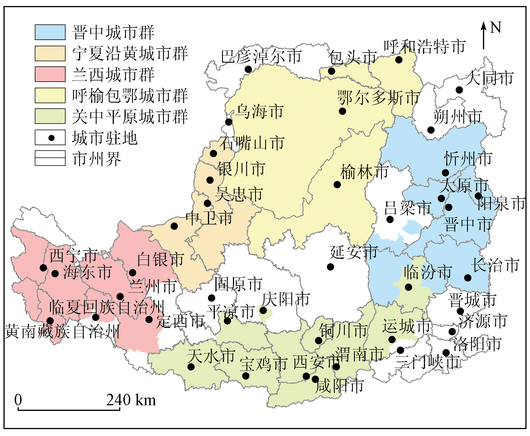
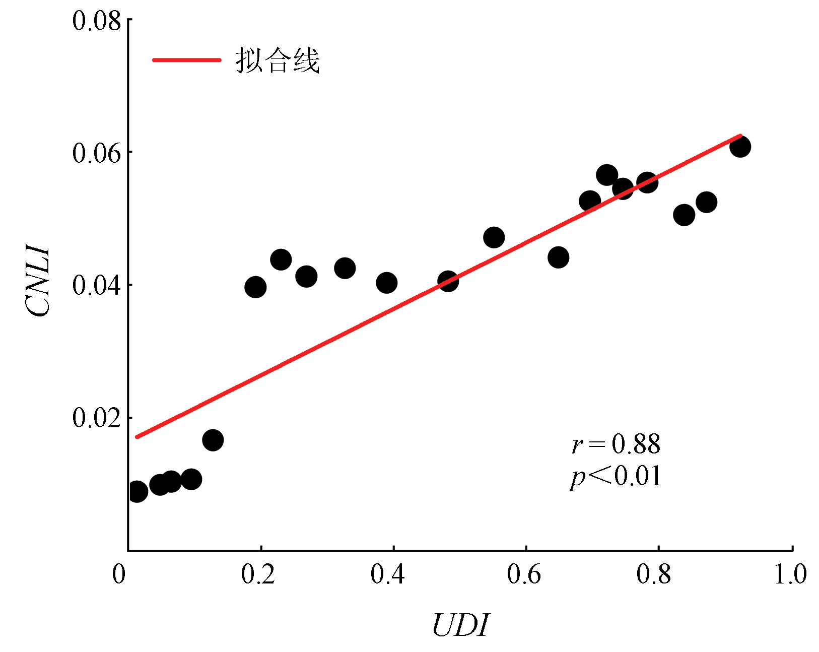
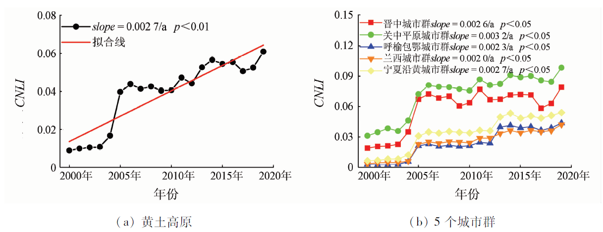
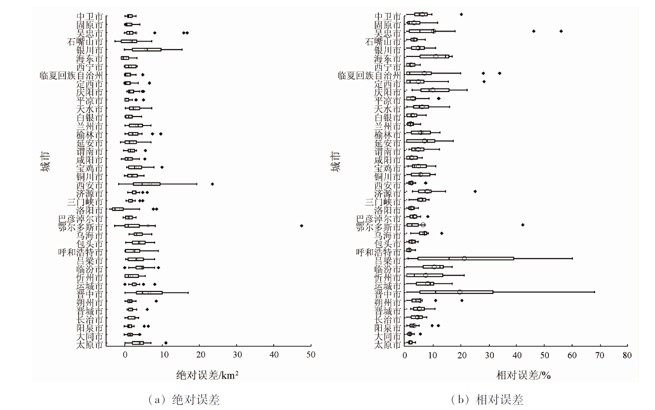
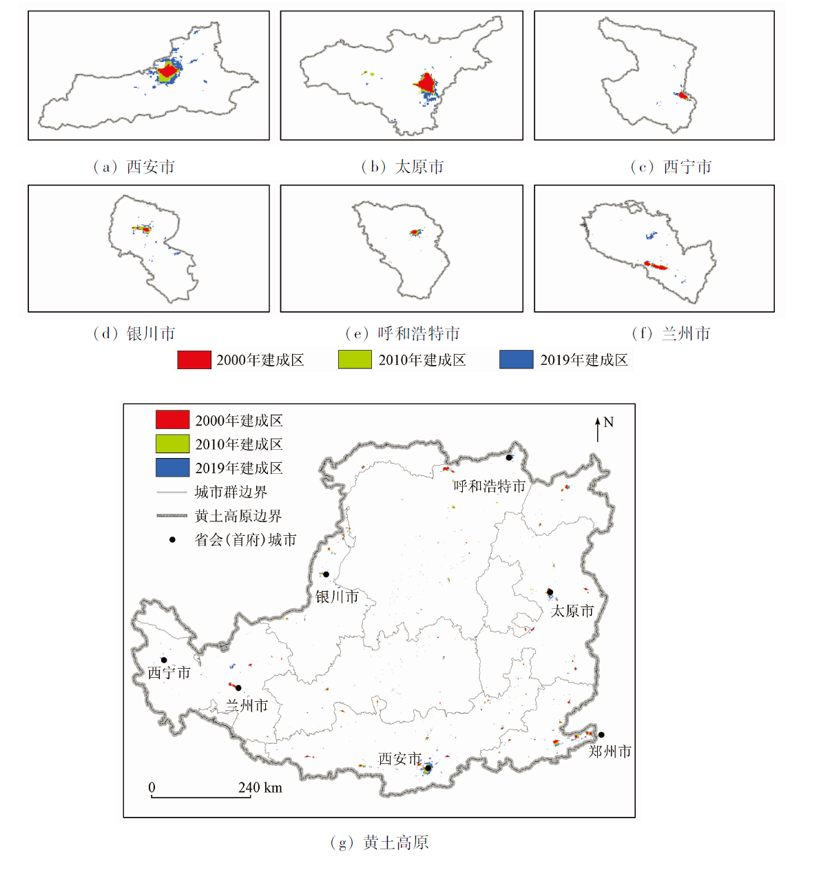
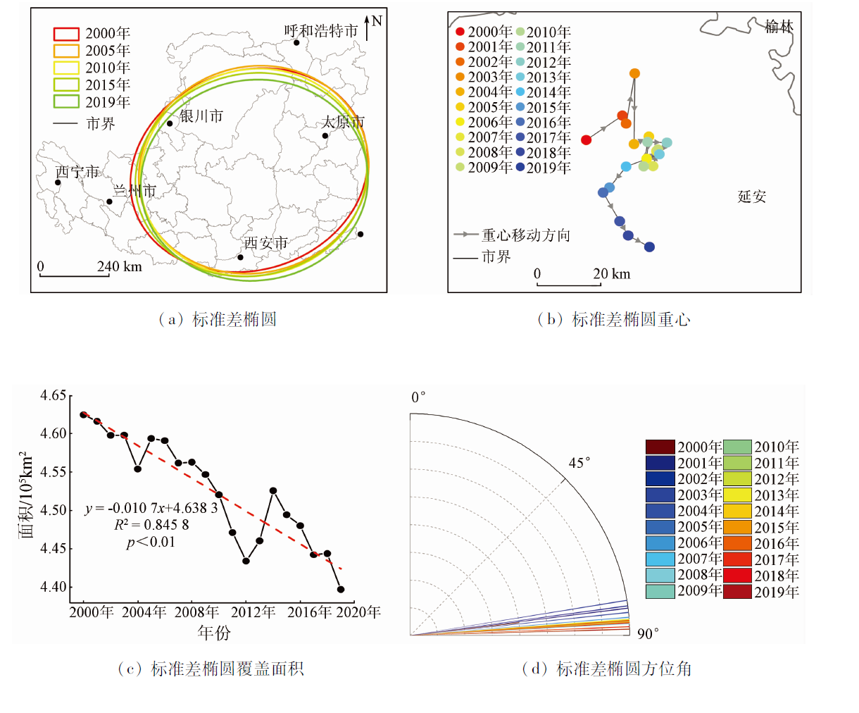
Abstract Research on the spatio-temporal evolution of urbanization is significant for optimizing the spatial structure of a city. Through the saturation and consistency correction of DMSP/OLS and NPP/VIIRS data, this study constructed a remote sensing dataset of night light in the Loess Plateau from 2000 to 2019. Then, this study calculated the compound night light index (CNLI) on different spatial scales and extracted the area of build-up areas in the Loess Plateau using a dichotomy method. Furthermore, this study analyzed the spatial evolution patterns using methods such as standard deviational ellipse (SDE). The results are as follows: ① The CNLI calculated from night light data correlated strongly with the urbanization development index (UDI) and various sub-indicators. ② The CNLI values of the Loess Plateau and five urban agglomerations showed significant upward trends during 2000—2019 and spatial downward trends from southeast to northwest. ③ The area of build-up areas in the Loess Plateau extracted using the dichotomy method had mean absolute and relative errors of 2.45 km2 and 3.72%, respectively. ④ The focus of the built-up areas in the Loess Plateau showed a southeastward shifting trend during 2000—2019, with the SDE-covered area decreasing significantly (slope = 0.0107 km2/a; p < 0.01) and the azimuth angle changing from northeastern 83.33° to 88.37°. The results of this study can provide data support and a methodological reference for investigating the spatio-temporal patterns of urbanization in the Loess Plateau and other ecologically vulnerable areas.
|
| Keywords
night light data
urbanization
CNLI
UDI
spatio-temporal evolution
Loess Plateau
|
|
|
|
Issue Date: 19 September 2023
|
|
|
| [1] |
樊杰, 郭锐. 新型城镇化前置条件与驱动机制的重新认知[J]. 地理研究, 2019, 38(1):3-12.
doi: 10.11821/dlyj020180444
|
| [1] |
Fan J, Guo R. Re-recognition of precondition and driving mechanism of new-type urbanization[J]. Geographical Research, 2019, 38(1):3-12.
doi: 10.11821/dlyj020180444
|
| [2] |
Wang Y H, Liu Z F, He C Y, et al. Quantifying urbanization levels on the Tibetan Plateau with high-resolution nighttime light data[J]. Geography and Sustainability, 2020, 1(3):233-244.
doi: 10.1016/j.geosus.2020.08.004
url: https://linkinghub.elsevier.com/retrieve/pii/S2666683920300419
|
| [3] |
Cai J, Li X P, Liu L J, et al. Coupling and coordinated development of new urbanization and agro-ecological environment in China[J]. Science of the Total Environment, 2021, 776(1): 145837.
doi: 10.1016/j.scitotenv.2021.145837
url: https://linkinghub.elsevier.com/retrieve/pii/S0048969721009049
|
| [4] |
Zhou W, Yu W, Qian Y, et al. Beyond city expansion:Multi-scale environmental impacts of urban megaregion formation in China[J]. National Science Review, 2022, 9: 107.
|
| [5] |
许正森, 徐永明. 整合DMSP/OLS和NPP/VIIRS夜间灯光遥感数据的长江三角洲城市格局时空演化研究[J]. 地球信息科学学报, 2021, 23(5):837-849.
doi: 10.12082/dqxxkx.2021.200380
|
| [5] |
Xu Z S, Xu Y M. Study on the spatio-temporal evolution of the Yangtze River Delta urban agglomeration by integrating DMSP/OLS and NPP/VIIRS nighttime light data[J]. Journal of Geo-Information Science, 2021, 23(5):837-849.
|
| [6] |
吴建楠, 程绍铂, 姚士谋. 中国城市群空间结构研究进展[J]. 现代城市研究, 2013, 28(12):97-101.
|
| [6] |
Wu J N, Cheng S B, Yao S M. Review and prospect of research on spatial structure of China’s urban agglomerations[J]. Modern Urban Research, 2013, 28(12):97-101.
|
| [7] |
Song Y Y, Ma B B, Dai L H, et al. Spatial-temporal pattern and formation mechanism of county urbanization on the Chinese Loess Plateau[J]. Journal of Mountain Science, 2021, 18(4):1093-1111.
doi: 10.1007/s11629-020-6282-1
|
| [8] |
赵安周, 刘宪锋, 裴韬, 等. 京津冀地区不透水表面覆盖率的时空演变及其对植被的影响[J]. 地理研究, 2021, 40(6):1582-1595.
doi: 10.11821/dlyj020200509
|
| [8] |
Zhao A Z, Liu X F, Pei T, et al. Spatiotemporal evolution of impervious surface percentage and its impact on vegetation in Beijing-Tianjin-Hebei region[J]. Geographical Research, 2021, 40(6):1582-1595.
doi: 10.11821/dlyj020200509
|
| [9] |
董鹤松, 李仁杰, 李建明, 等. 基于DMSP-OLS与NPP-VIIRS整合数据的中国三大城市群城市空间扩展时空格局[J]. 地球信息科学学报, 2020, 22(5):1161-1174.
doi: 10.12082/dqxxkx.2020.190711
|
| [9] |
Dong H S, Li R J, Li J M, et al. Study on urban spatiotemporal expansion pattern of three first-class urban agglomerations in China derived from integrated DMSP-OLS and NPP-VIIRS nighttime light data[J]. Journal of Geo-Information Science, 2020, 22(5):1161-1174.
|
| [10] |
陈颖彪, 郑子豪, 吴志峰, 等. 夜间灯光遥感数据应用综述和展望[J]. 地理科学进展, 2019, 38(2):205-223.
doi: 10.18306/dlkxjz.2019.02.005
|
| [10] |
Chen Y B, Zheng Z H, Wu Z F, et al. Review and prospect of application of nighttime light remote sensing data[J]. Progress in Geo-graphy, 2019, 38(2):205-223.
|
| [11] |
余柏蒗, 王丛笑, 宫文康, 等. 夜间灯光遥感与城市问题研究: 数据、方法、应用和展望[J]. 遥感学报, 2021, 25(1):342-364.
|
| [11] |
Yu B L, Wang C X, Gong W K, et al. Nighttime light remote sensing and urban studies: Data,methods,applications,and prospects[J]. National Remote Sensing Bulletin, 2021, 25(1):342-364.
doi: 10.11834/jrs.20211018
url: http://www.ygxb.ac.cn/zh/article/doi/10.11834/jrs.20211018/
|
| [12] |
Jiang L G, Liu Y, Wu S, et al. Study on urban spatial pattern based on DMSP/OLS and NPP/VIIRS in Democratic People’s Republic of Korea[J]. Remote Sensing, 2021, 13(23):4879.
doi: 10.3390/rs13234879
url: https://www.mdpi.com/2072-4292/13/23/4879
|
| [13] |
杜海波, 魏伟, 张学渊, 等. 黄河流域能源消费碳排放时空格局演变及影响因素——基于DMSP/OLS与NPP/VIIRS夜间灯光数据[J]. 地理研究, 2021, 40(7):2051-2065.
doi: 10.11821/dlyj020200646
|
| [13] |
Du H B, Wei W, Zhang X Y, et al. Spatio-temporal evolution and influencing factors of energy-related carbon emissions in the Yellow River basin:Based on the DMSP/OLS and NPP/VIIRS nighttime light data[J]. Geographical Research, 2021, 40(7):2051-2065.
|
| [14] |
Wang Y, Huang C, Zhao M, et al. Mapping the population density in Mainland China using NPP/VIIRS and points-of-interest data based on a random forests model[J]. Remote Sensing, 2020, 12(21):3645.
doi: 10.3390/rs12213645
url: https://www.mdpi.com/2072-4292/12/21/3645
|
| [15] |
Zhang B R, Li J, Wang M G, et al. Using DMSP/OLS and NPP/VIIRS images to analyze the expansion of 21 urban agglomerations in mainland China[J]. Journal of Urban Planning and Development, 2021, 147(3):04021024.
|
| [16] |
宋永永, 薛东前, 马蓓蓓, 等. 黄土高原城镇化过程及其生态环境响应格局[J]. 经济地理, 2020, 40(6):174-184.
|
| [16] |
Song Y Y, Xue D Q, Ma B B, et al. Urbanization process and its eco-logical environment response pattern on the Loess Plateau,China[J]. Economic Geography, 2020, 40(6):174-184.
|
| [17] |
周亮, 唐建军, 刘兴科, 等. 黄土高原人口密集区城镇扩张对生境质量的影响——以兰州、西安—咸阳及太原为例[J]. 应用生态学报, 2021, 32(1):261-270.
doi: 10.13287/j.1001-9332.202101.019
|
| [17] |
Zhou L, Tang J J, Liu X K, et al. Effects of urban expansion on habitat quality in densely populated areas on the Loess Plateau:A case study of Lanzhou,Xi’an-Xianyang and Taiyuan,China[J]. Chinese Journal of Applied Ecology, 2021, 32(1):261-270.
|
| [18] |
Fu B J, Wang S, Liu Y, et al. Hydrogeomorphic ecosystem responses to natural and anthropogenic changes in the Loess Plateau of China[J]. Annual Review of Earth and Planetary Sciences, 2017, 45:223-243.
doi: 10.1146/earth.2017.45.issue-1
url: https://www.annualreviews.org/toc/earth/45/1
|
| [19] |
Zhao A Z, Yu Q Y, Wang D L, et al. Spatiotemporal dynamics of ecosystem water use efficiency over the Chinese Loess Plateau base on long-time satellite data[J]. Environmental Science and Pollution Research, 2022, 29:2298-2310.
doi: 10.1007/s11356-021-15801-6
|
| [20] |
方创琳. 黄河流域城市群形成发育的空间组织格局与高质量发展[J]. 经济地理, 2020, 40(6): 1-8.
|
| [20] |
Fang C L. Spatial organization pattern and high-quality development of urban agglomeration in the Yellow River basin[J]. Economic Geography, 2020, 40(6): 1-8.
doi: 10.2307/142170
url: https://www.jstor.org/stable/142170?origin=crossref
|
| [21] |
Chen Z, Yu B, Yang C, et al. An extended time series (2000—2018) of global NPP-VIIRS-like nighttime light data from a cross-sensor calibration[J]. Earth System Science Data, 2021, 13(3):889-906.
doi: 10.5194/essd-13-889-2021
url: https://essd.copernicus.org/articles/13/889/2021/
|
| [22] |
孙阳, 刘新, 苏亚聪, 等. 基于夜间灯光数据估算安徽省县级尺度城镇化水平[J]. 地球信息科学学报, 2020, 22(9):1837-1847.
doi: 10.12082/dqxxkx.2020.190515
|
| [22] |
Sun Y, Liu X, Su Y C, et al. County urbanization level estimated from nighttime light data in Anhui Province[J]. Journal of Geo-Information Science, 2020, 22(9):1837-1847.
|
| [23] |
方创琳. 城市群地区城镇化与生态环境耦合机理及规律[M]. 北京: 科学出版社, 2021:213-214.
|
| [23] |
Fang C L. Coupling mechanism and law of urbanization and ecological environment in urban agglomeration[M]. Beijing: Science Press, 2021:213-214.
|
| [24] |
赵雪雁, 杜昱璇, 李花, 等. 黄河中游城镇化与生态系统服务耦合关系的时空变化[J]. 自然资源学报, 2021, 36(1):131-147.
|
| [24] |
Zhao X Y, Du Y X, Li H, et al. Spatio-temporal changes of the coupling relationship between urbanization and ecosystem services in the Middle Yellow River[J]. Journal of Natural Resources, 2021, 36(1):131-147.
doi: 10.31497/zrzyxb.20210109
|
| [25] |
Ma J J, Guo J Y, Ahmad S, et al. Constructing a new inter-calibration method for DMSP-OLS and NPP-VIIRS nighttime light[J]. Remote Sensing, 2020, 12(6):937.
doi: 10.3390/rs12060937
url: https://www.mdpi.com/2072-4292/12/6/937
|
| [26] |
Zhao M, Zhou Y Y, Li X C, et al. Building a series of consistent night-time light data (1992—2018) in Southeast Asia by integrating DMSP-OLS and NPP-VIIRS[J]. IEEE Transactions on Geoscience and Remote Sensing, 2019, 58(3):1843-1856.
doi: 10.1109/TGRS.36
url: https://ieeexplore.ieee.org/xpl/RecentIssue.jsp?punumber=36
|
| [27] |
陈晋, 卓莉, 史培军, 等. 基于DMSP/OLS数据的中国城市化过程研究——反映区域城市化水平的灯光指数的构建[J]. 遥感学报, 2003, 7(3):168-175,241.
|
| [27] |
Chen J, Zhuo L, Shi P J, et al. The study on urbanization process in China based on DMSP/OLS data:Development of a light index for urbanization level estimation[J]. Journal of Remote Sensing, 2003, 7(3):168-175,241.
|
| [28] |
冯雨雪, 李广东. 青藏高原城镇化与生态环境交互影响关系分析[J]. 地理学报, 2020, 75(7): 1386-1405.
doi: 10.11821/dlxb202007005
|
| [28] |
Feng Y X, Li G D. Interaction between urbanization and eco-environment in Tibetan Plateau[J]. Acta Geographica Sinica, 2020, 75(7):1386-1405.
doi: 10.11821/dlxb202007005
|
| [29] |
江原, 郝媛媛, 黄祎宸. 基于夜间灯光数据的甘青宁城市扩展及其建成区植被变化特征研究[J]. 生态学报, 2022, 42(10):3974-3988.
|
| [29] |
Jiang Y, Hao Y Y, Huang Y C. Characteristics of urban expansion and vegetation change in built-up areas of Gan-Qing-Ning based on nighttime light data[J]. Acta Ecologica Sinica, 2022, 42(10):3974-3988.
|
| [30] |
Lu C, Li L, Lei Y, et al. Coupling coordination relationship between urban sprawl and urbanization quality in the West Taiwan Strait urban agglomeration,China:Observation and analysis from DMSP/OLS nighttime light imagery and panel data[J]. Remote Sensing, 2020, 12(19):3217.
doi: 10.3390/rs12193217
url: https://www.mdpi.com/2072-4292/12/19/3217
|
| [31] |
路春燕, 许燕婷, 林晓晴, 等. 基于DMSP/OLS夜间灯光数据的环渤海城市群时空演变研究[J]. 国土资源遥感, 2019, 31(4):218-226.doi: 10.6046/gtzyyg.2019.04.28.
doi: 10.6046/gtzyyg.2019.04.28
|
| [31] |
Lu C Y, Xu Y T, Lin X Q, et al. Study of spatio-temporal evolution of the circum-Bohai urban agglomeration based on DMSP/OLS night-time light data[J]. Remote Sensing for Land and Resources, 2019,(31):218-226.doi: 10.6046/gtzyyg.2019.04.28.
doi: 10.6046/gtzyyg.2019.04.28
|
| [32] |
卓莉, 史培军, 陈晋, 等. 20世纪90年代中国城市时空变化特征——基于灯光指数CNLI方法的探讨[J]. 地理学报, 2003, 6:893-902.
|
| [32] |
Zhuo L, Shi P J, Chen J, et al. Application of compound night light index derived from DMSP/OLS data to urbanization analysis in China in the 1990s[J]. Acta Geographica Sinica, 2003, 6:893-902.
|
| [33] |
李俊峰, 潘竟虎. 基于夜间灯光的1992—2012年甘肃省城市空间扩展研究[J]. 冰川冻土, 2016, 38(3):829-835.
|
| [33] |
Li J F, Pan J H. Spatial expansion of cities at county-level or above in Gansu Province from 1992 to 2012 based on DMSP nighttime light images[J]. Journal of Glaciology and Geocryology, 2016, 38(3):829-835.
|
| [34] |
布自强, 白林波, 张佳瑜. 基于夜光遥感的宁夏沿黄城市群时空演变[J]. 自然资源遥感, 2022, 34(1):169-176.doi:10.6046/zrzyyg.2021118.
doi: 10.6046/zrzyyg.2021118
|
| [34] |
Bu Z Q, Bai L B, Zhang J Y. Spatio - temporal evolution of Ningxia urban agglomeration along the Yellow River based on nighttime light remote sensing[J]. Remote Sensing for Natural Resources, 2022, 34(1):169-176.doi:10.6046/zrzyyg.2021118.
doi: 10.6046/zrzyyg.2021118
|
| [35] |
史海金, 吴文恒, 李研, 等. 基于夜间灯光影像数据的黄河流域中心城市建成区空间扩展及动力因子分析[J]. 中国沙漠, 2021, 41(6):235-248.
doi: 10.7522/j.issn.1000-694X.2021.00126
|
| [35] |
Shi H J, Wu W H, Li Y, et al. Study on spatial expansion and dynamic factors of built-up area of central cities in the Yellow River basin based on night-time light data[J]. Journal of Desert Research, 2021, 41(6):235-248.
|
| [36] |
季顺伟, 马仁锋, 任丽燕. 2000年以来宁波城市空间扩展特征及其驱动力分析[J]. 宁波大学学报(理工版), 2021, 34(2):96-101.
|
| [36] |
Ji S W, Ma R F, Ren L Y. Spatial expansion characteristics of Ningbo City and its driving forces since 2000[J]. Journal of Ningbo University (Natural Science and Engineering Edition), 2021, 34(2):96-101.
|
|
Viewed |
|
|
|
Full text
|
|
|
|
|
Abstract
|
|
|
|
|
Cited |
|
|
|
|
| |
Shared |
|
|
|
|
| |
Discussed |
|
|
|
|
 2023,
Vol. 35
2023,
Vol. 35