|
|
 |
|

|
|
|
RandLA-Net-based detection of urban building change using airborne LiDAR point clouds |
MENG Congtang1( ), ZHAO Yindi1(), HAN Wenquan2, HE Chenyang1, CHEN Xiqiu2 ), ZHAO Yindi1(), HAN Wenquan2, HE Chenyang1, CHEN Xiqiu2 |
1. School of Environment Science and Spatial Informatics, China University of Mining and Technology, Xuzhou 221116, China
2. Nanjing Insititute of Surveying, Mapping and Geotechnical Investigation Co. Ltd., Nanjing 210019, China |
|
|
|
|
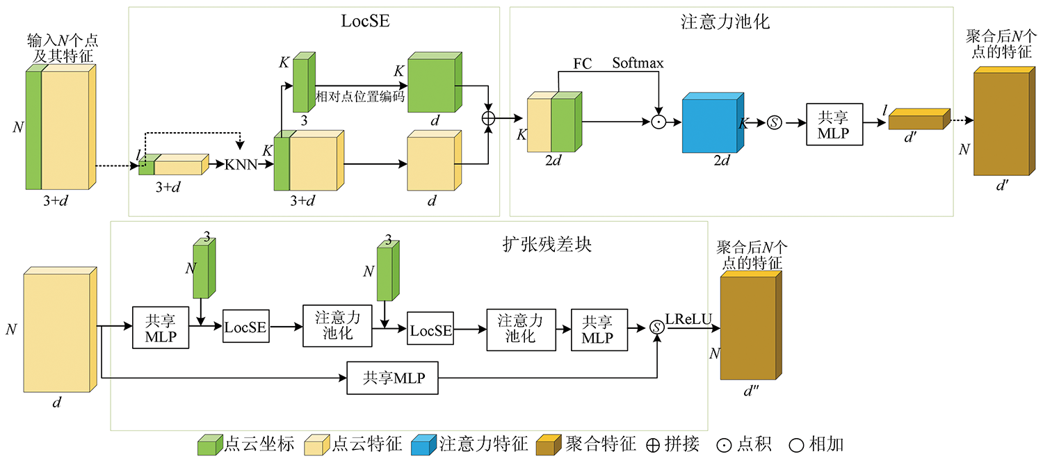
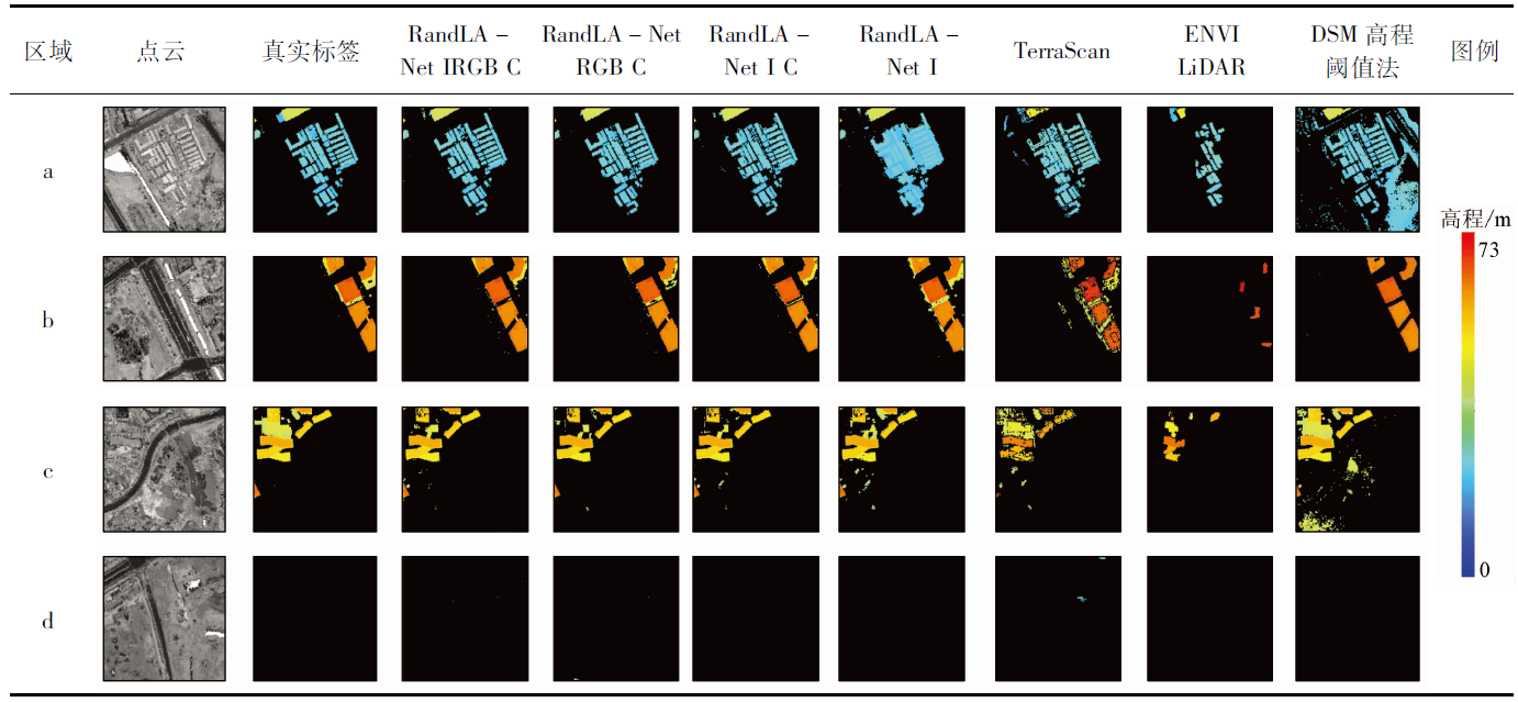
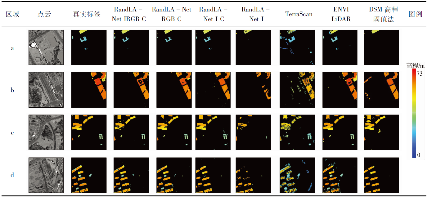
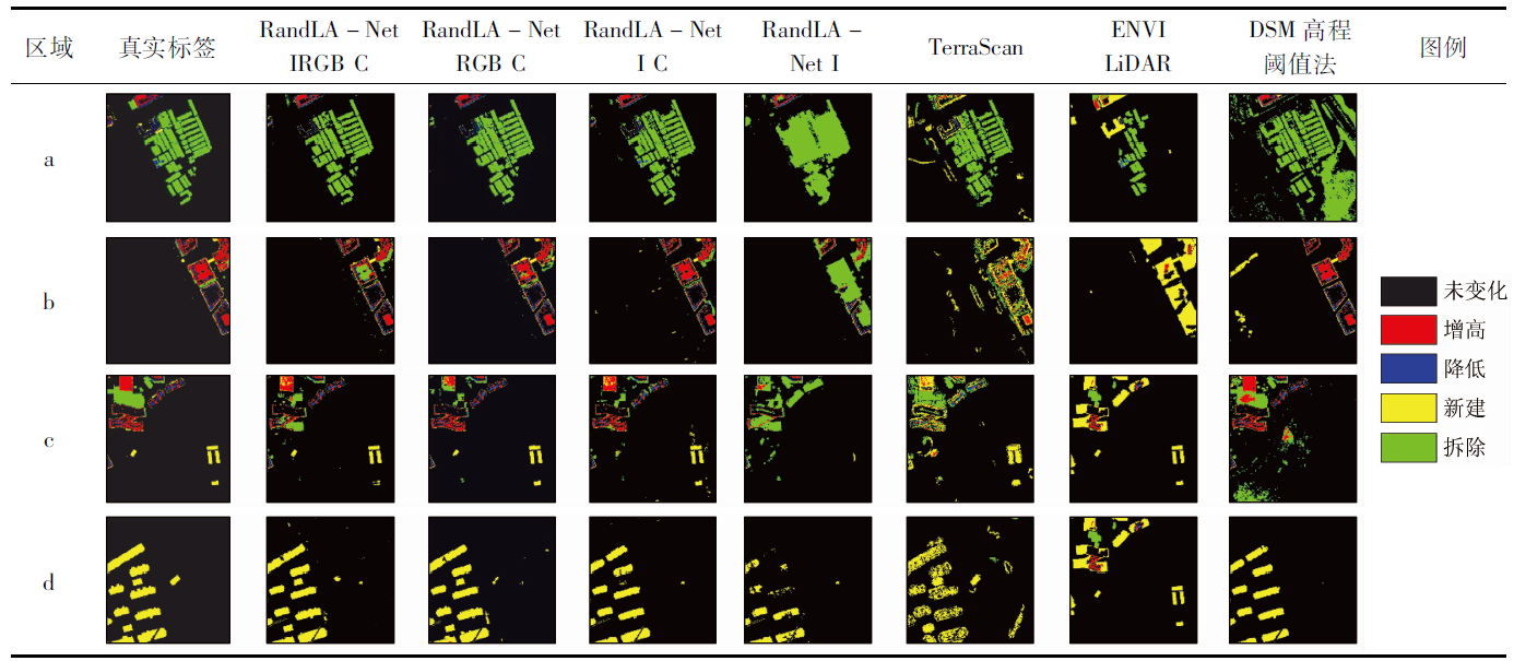
Abstract Using remote sensing to detect changes in urban buildings can obtain the change information of building coverage quickly and accurately. However, it is difficult to detect 3D changes quickly and accurately based on image data alone. Moreover, conventional point cloud-based methods have low automation and poor precision. To address these problems, this study used the airborne LiDAR point clouds and employed the RandLA-Net’s point cloud semantic segmentation method to improve the accuracy and automation of change detection. Meanwhile, the failure in differentiating two-period data due to point cloud disorder was overcome through point cloud projection. The standard RandLA-Net method, with the location and color information of points as features, is mainly used for semantic segmentation of street-level point clouds. In this study, urban large-scale airborne point clouds combined with the inherent reflection intensity and the spectral information of point clouds given by images were used to explore the influence of different feature information on the precision of the results. Furthermore, it was found that in addition to the point cloud intensity and spectral features, the coordinate information of points is equally important and can be converted into relative coordinates to significantly improve the result precision. The experimental findings show that the results obtained using RandLA-Net are significantly better than those using conventional methods for building extraction and change detection. This study also verified the feasibility of using deep learning methods to process LiDAR data for building extraction and change detection, which can realize reliable 3D building change detection.
|
| Keywords
airborne LiDAR
point cloud
change detection
3D semantic segmentation
|
|
|
|
Issue Date: 27 December 2022
|
|
|
| [1] |
Murakami H, Nakagawa K, Hasegawa H, et al. Change detection of buildings using an airborne laser scanner[J]. ISPRS Journal of Photogrammetry and Remote Sensing, 1999, 54(2):148-152.
doi: 10.1016/S0924-2716(99)00006-4
url: https://linkinghub.elsevier.com/retrieve/pii/S0924271699000064
|
| [2] |
Vu T, Matsuoka M, Yamazaki F. LiDAR-based change detection of buildings in dense urban areas[C]// IEEE International Geoscience and Remote Sensing Symposium (IGARSS), 2004:3413-3416.
|
| [3] |
Pang S, Hu X, Wang Z, et al. Object-based analysis of airborne LiDAR data for building change detection[J]. Remote Sensing, 2014, 6(11):10733-10749.
doi: 10.3390/rs61110733
url: http://www.mdpi.com/2072-4292/6/11/10733
|
| [4] |
Pirasteh S, Rashidi P, Rastiveis H, et al. Developing an algorithm for buildings extraction and determining changes from airborne LiDAR,and comparing with R-CNN method from drone images[J]. Remote Sensing, 2019, 11(11):1272.
doi: 10.3390/rs11111272
url: https://www.mdpi.com/2072-4292/11/11/1272
|
| [5] |
曾静静, 张晓刚, 王刚. 基于LiDAR点云的城区地表变化检测[J]. 城市勘测, 2021(2):92-95.
|
| [5] |
Zeng J J, Zhang X G, Wang G. Urban land surface change detection based on LiDAR point cloud[J]. Urban Geotechnical Investigation and Surveying, 2021(2):92-95.
|
| [6] |
Matikainen L, Hyyppä J, Ahokas E, et al. Automatic detection of buildings and changes in buildings for updating of maps[J]. Remote Sensing, 2010, 2(5):1217-1248.
doi: 10.3390/rs2051217
url: http://www.mdpi.com/2072-4292/2/5/1217
|
| [7] |
Malpica J A, Alonso M C. Urban changes with satellite imagery and LiDAR data[J]. International Archives of the Photogrammetry,Remote Sensing and Spatial Information Science, 2010, 38(8):853-858.
|
| [8] |
Du S, Zhang Y, Qin R, et al. Building change detection using old aerial images and new LiDAR data[J]. Remote Sensing, 2016, 8(12):1030.
doi: 10.3390/rs8121030
url: http://www.mdpi.com/2072-4292/8/12/1030
|
| [9] |
Shelhamer E, Long J, Darrell T. Fully convolutional networks for semantic segmentation[J]. IEEE Transactions on Pattern Analysis and Machine Intelligence, 2017, 39(4):640-651.
doi: 10.1109/TPAMI.2016.2572683
pmid: 27244717
|
| [10] |
Simonyan K, Zisserman A. Very deep convolutional networks for large-scale image recognition[J/OL]. arXiv, 2014(2015-04-10)[2022-10/15]. https://arxiv.org/abs/1409.1556 .
url: https://arxiv.org/abs/1409.1556
|
| [11] |
Badrinarayanan V, Kendall A, Cipolla R. Segnet:A deep convolutional encoder-decoder architecture for image segmentation[J]. IEEE Transactions on Pattern Analysis and Machine Intelligence, 2017, 39(12):2481-2495.
doi: 10.1109/TPAMI.2016.2644615
pmid: 28060704
|
| [12] |
He K, Zhang X, Ren S, et al. Deep residual learning for image reco-gnition[C]// Proceedings of the IEEE Conference on Computer Vision and Pattern Recognition, 2016:770-778.
|
| [13] |
Ronneberger O, Fischer P, Brox T. U-Net:Convolutional networks for biomedical image segmentation[C]// International Conference on Medical Image Computing and Computer-Assisted Intervention.Springer,Cham, 2015:234-241.
|
| [14] |
Ren S, He K, Girshick R, et al. Faster R-CNN:Towards real-time object detection with region proposal networks[J]. IEEE Transactions on Pattern Analysis and Machine Intelligence, 2016, 39(6):1137-1149.
doi: 10.1109/TPAMI.2016.2577031
url: http://ieeexplore.ieee.org/document/7485869/
|
| [15] |
Lin T Y, Dollár P, Girshick R, et al. Feature pyramid networks for object detection[C]// Proceedings of the IEEE Conference on Computer Vision and Pattern Recognition, 2017:2117-2125.
|
| [16] |
谢奇芳, 姚国清, 张猛. 基于Faster R-CNN的高分辨率图像目标检测技术[J]. 国土资源遥感, 2019, 31(2):38-43.doi:10.6046/gtzyyg.2019.02.06.
doi: 10.6046/gtzyyg.2019.02.06
|
| [16] |
Xie Q F, Yao G Q, Zhang M. Research on high resolution image object detection technology based on Faster R-CNN[J]. Remote Sensing for Land and Resources, 2019, 31(2):38-43.doi:10.6046/gtzyyg.2019.02.06.
doi: 10.6046/gtzyyg.2019.02.06
|
| [17] |
武宇, 张俊, 李屹旭, 等. 基于改进U-Net的建筑物集群识别研究[J]. 国土资源遥感, 2021, 33(2):48-54.doi:10.6046/gtzyyg.2020278.
doi: 10.6046/gtzyyg.2020278
|
| [17] |
Wu Y, Zhang J, Li Y X, et al. Research on building cluster identification based on improved U-Net[J]. Remote Sensing for Land and Resources, 2021, 33(2):48-54.doi:10.6046/gtzyyg.2020278.
doi: 10.6046/gtzyyg.2020278
|
| [18] |
卢麒, 秦军, 姚雪东, 等. 基于多层次感知网络的GF-2遥感影像建筑物提取[J]. 国土资源遥感, 2021, 33(2):75-84.doi:10.6046/gtzyyg.2020289.
doi: 10.6046/gtzyyg.2020289
|
| [18] |
Lu Q, Qin J, Yao X D, et al. Buildings extraction of GF-2 remote sensing image based on multi-layer perception network[J]. Remote Sensing for Land and Resources, 2021, 33(2):75-84.doi:10.6046/gtzyyg.2020289.
doi: 10.6046/gtzyyg.2020289
|
| [19] |
刘文雅, 岳安志, 季钰, 等. 基于DeepLabv3+语义分割模型的GF-2影像城市绿地提取[J]. 国土资源遥感, 2020, 32(2):120-129.doi:10.6046/gtzyyg.2020.02.16.
doi: 10.6046/gtzyyg.2020.02.16
|
| [19] |
Liu W Y, Yue A Z, Ji Y, et al. Urban green space extraction from GF-2 remote sensing image based on DeepLabv3+ semantic segmentation model[J]. Remote Sensing for Land and Resources, 2020, 32(2):120-129.doi:10.6046/gtzyyg.2020.02.16.
doi: 10.6046/gtzyyg.2020.02.16
|
| [20] |
安健健, 孟庆岩, 胡蝶, 等. 基于Faster R-CNN的火电厂冷却塔检测及工作状态判定[J]. 国土资源遥感, 2021, 33(2):93-99.doi:10.6046/gtzyyg.2020184.
doi: 10.6046/gtzyyg.2020184
|
| [20] |
An J J, Meng Q Y, Hu D, et al. The detection and determination of the working state of cooling tower in the thermal power plant based on Faster R-CNN[J]. Remote Sensing for Land and Resources, 2021, 33(2):93-99.doi:10.6046/gtzyyg.2020184.
doi: 10.6046/gtzyyg.2020184
|
| [21] |
Guo Y, Wang H, Hu Q, et al. Deep learning for 3D point clouds:A survey[J]. IEEE Transactions on Pattern Analysis and Machine Intelligence, 2020, 43(12):4338-4364.
doi: 10.1109/TPAMI.2020.3005434
url: https://ieeexplore.ieee.org/document/9127813/
|
| [22] |
Qi C R, Su H, Mo K, et al. Pointnet:Deep learning on point sets for 3D classification and segmentation[C]// Proceedings of the IEEE Conference on Computer Vision and Pattern Recognition, 2017:652-660.
|
| [23] |
Wu B, Wan A, Yue X, et al. Squeezeseg:Convolutional neural nets with recurrent CRF for real-time road-object segmentation from 3D LiDAR point cloud[C]// 2018 IEEE International Conference on Robotics and Automation (ICRA), 2018:1887-1893.
|
| [24] |
Thomas H, Qi C R, Deschaud J E, et al. Kpconv:Flexible and deformable convolution for point clouds[C]// Proceedings of the IEEE/CVF International Conference on Computer Vision, 2019:6411-6420.
|
| [25] |
Hu Q, Yang B, Xie L, et al. RandLA-Net:Efficient semantic segmentation of large-scale point clouds[C]// Proceedings of the IEEE/CVF Conference on Computer Vision and Pattern Recognition, 2020:11108-11117.
|
| [26] |
Hackel T, Savinov N, Ladicky L, et al. Semantic3d.net:A new large-scale point cloud classification benchmark[J/OL]. arXiv, 2017(2017-04-12)[2022-10/15]. https://arxiv.org/abs/1704.03847 .
url: https://arxiv.org/abs/1704.03847
|
|
Viewed |
|
|
|
Full text
|
|
|
|
|
Abstract
|
|
|
|
|
Cited |
|
|
|
|
| |
Shared |
|
|
|
|
| |
Discussed |
|
|
|
|
 2022,
Vol. 34
2022,
Vol. 34