Please wait a minute...
 
Remote Sensing for Natural Resources    2023, Vol. 35 Issue (2) : 264-270     DOI: 10.6046/zrzyyg.2022120
|
The “one survey for multiple purposes” classification system for integrated survey and monitoring of natural resources
JIANG Yi(), MA Kewei, WANG Yunkai, YANG Hongjun, HE Yanlan
Jiangsu Geologic Surveying and Mapping Institute, Nanjing 211102, China
Download: PDF(1885 KB)   HTML
Export: BibTeX | EndNote | Reference Manager | ProCite | RefWorks    
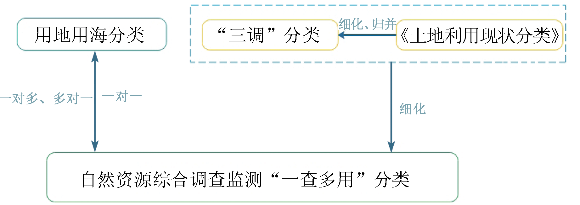
Abstract  

Based on the technical research task of “one survey for multiple purposes” in the national pilot project of integrated survey and monitoring of natural resources, this study aims to connect multiple special surveys of natural resources and multisectoral purposes through one integrated survey. First, this study analyzed the existing land classification and the Guidelines for the Classification of Land and Sea Use for Land and Space Survey, Planning, and Use Control (trial). Then, it formulated the criteria for the classification of “one survey for multiple purposes” for the integrated survey and monitoring of natural resources by subdividing some land categories according to the Land Use Classification. Moreover, the verification results show that the criteria for the classification enable the mutual conversion of classifications, such as land and sea use classification and land survey classification, and can connect to special surveys by rapidly providing special resource survey layers.

Keywords natural resources      survey and monitoring      one survey for multiple purposes      classification system     
ZTFLH:  TP79  
Issue Date: 07 July 2023
Service
E-mail this article
E-mail Alert
RSS
Articles by authors
Yi JIANG
Kewei MA
Yunkai WANG
Hongjun YANG
Yanlan HE
Cite this article:   
Yi JIANG,Kewei MA,Yunkai WANG, et al. The “one survey for multiple purposes” classification system for integrated survey and monitoring of natural resources[J]. Remote Sensing for Natural Resources, 2023, 35(2): 264-270.
URL:  
https://www.gtzyyg.com/EN/10.6046/zrzyyg.2022120     OR     https://www.gtzyyg.com/EN/Y2023/V35/I2/264
Fig.1  The design of land classification
需细化地类 细化后地类 用地用海分类
编号 类别 编号 类别 二级类 三级类
0507 其他商服用地 0507KT 康体商服用地 0903 娱乐康体用地 090302 康体用地
0507GY 公用设施营业网点用地 0901 商业用地 090105 公用设施营业网点用地
0507QT 其他商服用地 0904 其他商业服务业用地
0809 公用设施用地 0809GS 供水用地 1301 供水用地
0809PS 排水用地 1302 排水用地
0810 公园与绿地 0810GY 公园绿地 1401 公园绿地
0810FH 防护绿地 1402 防护绿地
0810GC 广场用地 1403 广场用地
0906 风景名胜设施用地 0906WG 文物古迹用地 1504 文物古迹用地
0906QT 其他风景名胜设施用地 1507 其他特殊用地
1004 城镇村道路用地 1004CZ 城镇道路用地 1207 城镇道路用地
1004NC 村庄内部道路用地 0601 乡村道路用地 060102 村庄内部道路用地
1005 交通服务场站用地 1005KY 公路客运场站 1208 交通场站用地 120801 对外交通场站用地
1005GJ 公共交通场站 120802 公共交通场站用地
1005TC 公共停车场 120803 社会停车场用地
1005QT 其他场站用地 1209 其他交通设施用地
1006 农村道路 1006CD 村道用地 0601 乡村道路用地 060101 村道用地
1006TJ 田间道 2303 田间道
1008 港口码头用地 1008KY 港口客运场站 1208 交通场站用地 120801 对外交通场站用地
1008LD 港口轮渡场站 120802 公共交通场站用地
1008QT 其他港口码头 1204 港口码头用地
1202 设施农用地 1202ZZ 种植设施建设用地 0602 种植设施建设用地
1202CQ 畜禽养殖设施建设用地 0603 畜禽养殖设施建设用地
1202SC 水产养殖设施建设用地 0604 水产养殖设施建设用地
0803 教育用地 0803GD 高等教育用地 0804 教育用地 080401 高等教育用地
0803ZD 中等职业教育用地 080402 中等职业教育用地
0803ZX 中小学用地 080403 中小学用地
0803YE 幼儿园用地 080404 幼儿园用地
0803QT 其他教育用地 080405 其他教育用地
0805 医疗卫生用地 0805YY 医院用地 0806 医疗卫生用地 080601 医院用地
0805JC 基层医疗卫生设施用地 080602 基层医疗卫生设施用地
0805GG 公共卫生用地 080603 公共卫生用地
0806 社会福利用地 0806LN 老年人社会福利用地 0807 社会福利用地 080701 老年人社会福利用地
0806ET 儿童社会福利用地 080702 儿童社会福利用地
0806CJ 残疾人社会福利用地 080703 残疾人社会福利用地
0806QT 其他社会福利用地 080704 其他社会福利用地
0807 文化设施用地 0807TS 图书与展览用地 0803 文化用地 080301 图书与展览用地
0807WH 文化活动用地 080302 文化活动用地
0808 体育用地 0808CG 体育场馆用地 0805 体育用地 080501 体育场馆用地
0808XL 体育训练用地 080502 体育训练用地
Tab.1  The refinement of “05”—“12” (part)
需细化地类 细化后地类 用地用海分类
编号 类别 编号 类别 二级类 三级类
0604 仓储用地 0604CB 储备库用地 1102 储备库用地
1001 铁路用地 1001TL 铁路场站 1208 交通场站用地 120801 对外交通场站用地
1002 轨道交通用地 1002GD 轨道交通场站 1208 交通场站用地 120802 公共交通场站用地
1107 沟渠 1107GQ 干渠 1311 干渠
Tab.2  Definition of inconsistent content refinement table
需细化地类 细化后地类 用地用海分类
编号 类别 编号 类别 编号 类别
0501 零售商业用地 0501CZ 城镇社区小型超市 0702 城镇社区服务设施用地
0501NC 农村商店 0704 农村社区服务设施用地
0507 其他商服用地 0507NC 农机服务站等 0704 农村社区服务设施用地
0702 农村宅基地 0702NC 宗祠用地 0704 农村社区服务设施用地
0801 机关团体用地 0801CZ 城镇社区服务站 0702 城镇社区服务设施用地
0801NC 农村社区服务站和村委会 0704 农村社区服务设施用地
0805 医疗卫生用地 0805CZ 社区卫生服务站 0702 城镇社区服务设施用地
0805NC 农村卫生服务站 0704 农村社区服务设施用地
0806 社会福利用地 0806CZ 城镇社区养老服务设施 0702 城镇社区服务设施用地
0806NC 农村社区托儿所 0704 农村社区服务设施用地
0807 文化设施用地 0807CZ 城镇文化活动站 0702 城镇社区服务设施用地
0807NC 农村社区文化活动室 0704 农村社区服务设施用地
0808 体育用地 0808CZ 城镇小型综合体育场地 0702 城镇社区服务设施用地
0808NC 农村小型体育活动场地 0704 农村社区服务设施用地
0809 公用设施用地 0809NC 农村社区服务设施 0704 农村社区服务设施用地
Tab.3  Special class subdivision table
“一查多用”分类 用地用海分类
一级类 二级类 细化地类 一级类 二级类
13 用海 1301 渔业用海 1301YY 渔业基础设施用海 18 渔业用海 1801 渔业基础设施用海
1302 工矿通信用海 1302YT 盐田用海 19 工矿通信用海 1902 盐田用海
14 地下空间 1401 地下交通运输设施 1401RX 地下人行通道 UG12 地下交通运输设施 UG1210 地下人行通道
Tab.4  The design of land classification of sea land
Fig.2  Schematic diagram of pilot area
“一查多用”分类 “三调”分类 用地用海分类
一级类 二级类 含义及细化分类 一级类 二级类 一级类 二级类
03 林地 0301 乔木林地 03 林地 0301 乔木林地 03 林地 0301 乔木林地
0302 竹林地 0302 竹林地 0302 竹林地
0303 红树林地 00 湿地 0303 红树林地 05 湿地 0507 红树林地
0304 森林沼泽 0304 森林沼泽 0501 森林沼泽
03 林地 0305 灌木林地 0305TS 特殊灌木林地 03 林地 0305 灌木林地 03 林地 0303 灌木林地
0305YB 一般灌木林地
0306 灌丛沼泽 00 湿地 0306 灌丛沼泽 05 湿地 0502 灌丛沼泽
0307 其他林地 0307SL 疏林地 03 林地 0307 其他林地 03 林地 0304 其他林地
0307RG 人工造林未成林地
0307FY 封育地未成林地
0307CF 采伐迹地
0307HS 火烧迹地
0307JD 其他迹地
0307MP 苗圃
0307QT 其他林地
Tab.5  The relationship among designs of land classification(part)
Fig.3  Flow chart of connection and application of forest special investigation
[1] 顾龙友. 关于创新完善国家自然资源督察制度若干思考[J]. 中国国土资源经济, 2020, 33(6):10-17.
[1] Gu L Y. Thoughts on innovation and improvement of national natural resources supervision system[J]. Natural Resource Economics of China, 2020, 33(6):10-17.
[2] 中国国土资源经济研究编写组. 科学划分自然资源类型推进统一管理系统治理[N]. 中国自然资源报,2018-6-21(5).
[2] China Land resources Economy Research Editorial Group. Scientific classification of natural resources to promote unified management system governance[N]. China Natural Resources News,2018-6-21(5).
[3] 龚健, 李靖业, 韦兆荣, 等. 面向自然资源统一管理的国土空间规划用地分类体系及用途管制探索[J]. 规划师, 2020, 36(10):42-49.
[3] Gong J, Li J Y, Wei Z R, et al. Land use classification system and governance for unified management of natural resources[J]. Planners, 2020, 36(10):42-49.
[4] 乔朝飞, 赵原, 刘一. 从地理国情普查数据与资源环境调查数据对比看地理国情监测未来发展[J]. 测绘与空间地理信息, 2019, 42(1):7-9.
[4] Qiao C F, Zhao Y, Liu Y. From comparison between national geographic condition census data and resources and environment investigation data to development of national geographic condition monitoring[J]. Geomatics & Spatial Information Technology, 2019, 42(1):7-9.
[5] 陈海鹏, 张莉, 郭婧, 等. 地表覆盖分类数据成果质量检查技术与方法[J]. 测绘与空间地理信息, 2018, 41(7):72-74.
[5] Chen H P, Zhang L, Guo J, et. Studies on method of quality inspection for land cover achievement[J]. Geomatics and Spatial Information Technology, 2018, 41(7):72-74.
[6] 叶远智, 张朝忙, 邓轶, 等. 我国自然资源、自然资源资产监测发展现状及问题分析[J]. 测绘通报, 2019(10):23-29.
doi: 10.13474/j.cnki.11-2246.2019.0312
[6] Ye Y Z, Zhang C M, Deng Y, et al. Research on the current situation and problems of natural resources monitoring and natural resources assets monitoring in China[J]. Bulletin of Surveying and Mapping, 2019(10):23-29.
doi: 10.13474/j.cnki.11-2246.2019.0312
[7] 李德仁, 张良培, 夏桂松. 遥感大数据自动分析与数据挖掘[J]. 测绘学报, 2014, 43(12):1211-1216.
doi: 10.13485/j.cnki.11-2089.2014.0187
[7] Li D R, Zhang L P, Xia G S. Automatic analysis and mining of remote sensing big data[J]. Acta Geodaetica et Cartographica Sinica, 2014, 43(12):1211-1216.
doi: 10.13485/j.cnki.11-2089.2014.0187
[8] 黄景金, 唐长增, 李毅, 等. 广西自然资源调查监测体系构建[J]. 国土资源遥感, 2020, 32(2):154-161.doi:10.6046/gtzyyg.2020.02.20.
doi: 10.6046/gtzyyg.2020.02.20
[8] Huang J J, Tang C Z, Li Y, et al. System construction for survey and monitoring of natural resources in Guangxi[J]. Remote Sensing for Land and Resources, 2020, 32(2):154-161.doi:10.6046/gtzyyg.2020.02.20.
doi: 10.6046/gtzyyg.2020.02.20
[9] 程遥, 赵民. 国土空间规划用地分类标准体系建构探讨——分区分类结构与应用逻辑[J]. 城市规划学刊, 2021(4):51-57.
[9] Cheng Y, Zhao M. On the land-use classification system in the context of territorial spatial planning:Classification structure and application rationale[J]. Urban Planning Forum, 2021(4):51-57.
[10] 刘婷. 我国土地利用分类体系发展历程及其展望[J]. 城市建筑, 2020, 17(12):38-39,42.
[10] Liu T. Evolution and prospect of land use classification system in China[J]. Urbanism and Architecture, 2020, 17(12):38-39,42.
[1] HU Chenxia, ZOU Bin, LIANG Yu, HE Chencheng, LIN Zhijia. Spatio-temporal evolution of gross ecosystem product with high spatial resolution: A case study of Hunan Province during 2000—2020[J]. Remote Sensing for Natural Resources, 2023, 35(3): 179-189.
[2] HUANG Tao, LIU Xiaoping, WU Jiaping, XIAO Yanling, ZHANG Yuchen. Design and development of an information system for the accounting of state-owned land resource assets[J]. Remote Sensing for Natural Resources, 2022, 34(3): 249-256.
[3] XIONG Yujiu, ZHAO Shaohua, YAN Chunhua, QIU Gouyu, SUN Hua, WANG Yanlin, QIN Longjun. A comparative study of methods for monitoring and assessing urban green space resources at multiple scales[J]. Remote Sensing for Land & Resources, 2021, 33(1): 54-62.
[4] WANG Yuefeng, WU Huizhi, HE Shujun, HUANG Di, BAI Chaojun. Method research of intelligentized extraction of natural resources information from Shihe District,Xinyang City,Henan Province[J]. Remote Sensing for Land & Resources, 2020, 32(4): 244-250.
[5] ZHANG Chaomang, YE Yuanzhi, DENG Yi, WANG Jianbang. Review on the development of natural resources monitoring technology and equipment in China[J]. Remote Sensing for Land & Resources, 2020, 32(3): 8-14.
[6] Jingjin HUANG, Changzeng TANG, Yi LI, Tianhui ZUO, Zhengbei YANG. System construction for survey and monitoring of natural resources in Guangxi[J]. Remote Sensing for Land & Resources, 2020, 32(2): 154-161.
[7] Ling CHEN, Jia JIA, Haiqing WANG. An overview of applying high resolution remote sensing to natural resources survey[J]. Remote Sensing for Land & Resources, 2019, 31(1): 1-7.
[8] Yuling ZHAO. Remote sensing survey and proposal for protection of the natural resources in Guangdong-Hong Kong-Macao Greater Bay Area[J]. Remote Sensing for Land & Resources, 2018, 30(4): 139-147.
[9] WEN Li, WU Haiping, JIANG Fangfang, SU Wei, ZHU Dehai, ZHANG Chao. Establishment of remote sensing monitoring classification system and interpretation criteria for the reclamation area based on the high-resolution remote sensing image[J]. REMOTE SENSING FOR LAND & RESOURCES, 2016, 28(1): 172-177.
Viewed
Full text


Abstract

Cited

  Shared   
  Discussed   
京ICP备05055290号-2
Copyright © 2017 Remote Sensing for Natural Resources
Support by Beijing Magtech