|
|
 |
|

|
|
|
Spatio-temporal evolution of ecosystem health in Anhui Province from 1980 to 2015 |
WANG Zuo1,2( ), WANG Meng1,2, WANG Changchang1,2, LI Hu1,2, ZHANG Yun1,2 ), WANG Meng1,2, WANG Changchang1,2, LI Hu1,2, ZHANG Yun1,2 |
1. School of Geography and Tourism, Anhui Normal University, Wuhu 241002, China
2. Engineering Technology Research Center of Resources Environment and GIS, Anhui Normal University, Wuhu 241002, China |
|
|
|
|
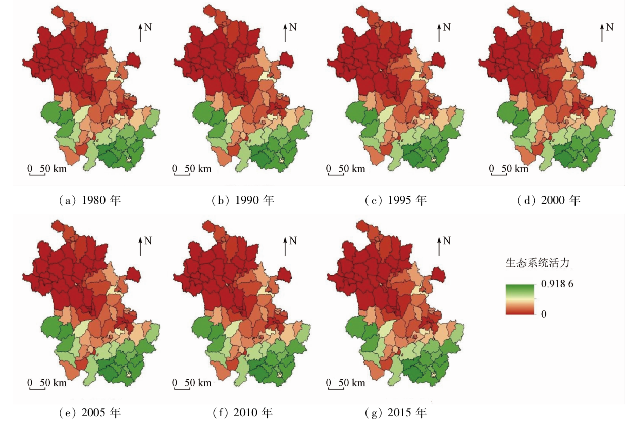
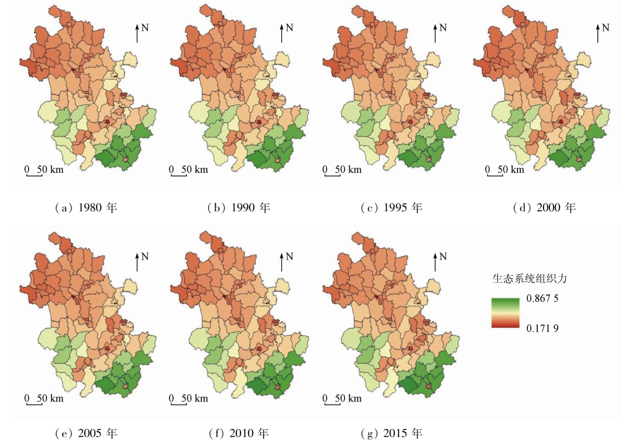
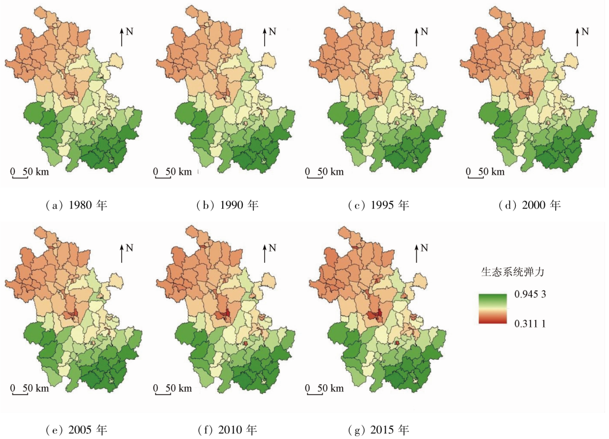
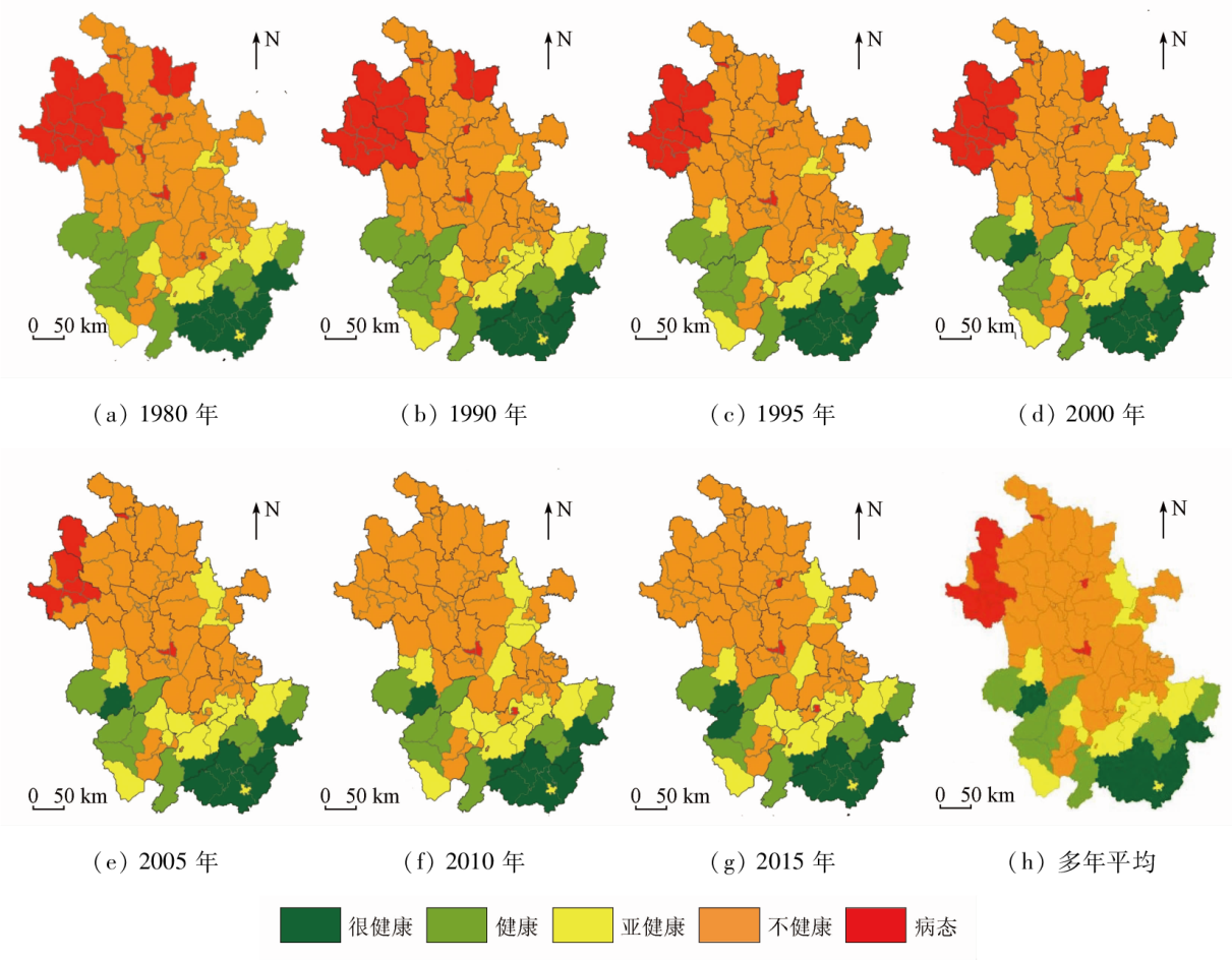
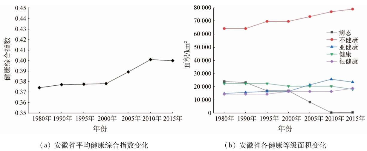
Abstract To explore the ecosystem health of Anhui Province in the context of modern urbanization, this study established an ecosystem health evaluation system for Anhui Province based on time-series land use type data using the vigour-organization-resilience (VOR) model. Then, this study defined the weights of indicators in the evaluation system using the entropy weight method and evaluated the ecosystem health of Anhui Province and its spatio-temporal evolution over the period from 1980 to 2015 on the county scale. The results show that: ① Anhui Province was dominated by counties with an unhealthy ecosystem, followed by counties with a subhealthy ecosystem, both of which accounted for 56.37% and 16.83%, respectively. Spatially, the comprehensive average multiyear health index and average multiyear health grade of Anhui Province’s ecosystem were higher in the south and lower in the north, strongly correlating with the landform type. Areas with Healthy and very healthy ecosystems were mostly distributed in the hilly and mountainous areas in the southern and western parts of the province. In contrast, areas with an unhealthy ecosystem were contiguously distributed in the Huai River Plain, the Jianghuai hilly area, and the plain area along the Yangtze River. Among, Qimen County, Huangshan City exhibited the highest comprehensive ecosystem health index of 0.92, and Luyang District of Hefei City displayed the lowest comprehensive ecosystem health index of about 0.17; ② The overall ecosystem of Anhui Province showed a healthy trend from 1980 to 2015. With 24 counties exhibiting increasing health grades and no counties displaying decreasing health grades, the average provincial health grade increased from unhealthy to subhealthy grades. Nevertheless, 13 counties exhibited decreasing comprehensive health index values, indicating unstable ecosystem health levels and risks of decreasing health grades. The findings of the study can, to some extent, provide a reference for Anhui Province to formulate reasonable land use policies, protect and manage the eco-environment, and optimize ecosystem service functions.
|
| Keywords
temporal and spatial evolution
ecosystem
health assessment
Anhui Province
|
|
|
|
Issue Date: 21 December 2023
|
|
|
| [1] |
王同达, 曹锦雪, 赵永华, 等. 基于PSR模型的陕西省土地生态系统健康评价[J]. 应用生态学报, 2021, 32(5):1563-1572.
doi: 10.13287/j.1001-9332.202105.013
|
| [1] |
Wang T D, Cao J X, Zhao Y H, et al. Evaluation of land ecosystem health in Shaanxi Province,Northwest China based on PSR Model[J]. Chinese Journal of Applied Ecology, 2021, 32(5):1563-1572.
|
| [2] |
陈利顶, 孙然好, 刘海莲. 城市景观格局演变的生态环境效应研究进展[J]. 生态学报, 2013, 33(4):1042-1050.
|
| [2] |
Chen L D, Sun R H, Liu H L. Eco-environmental effects of urban landscape pattern changes:Progresses,problems,and perspectives[J]. Acta Ecologica Sinica, 2013, 33(4):1042-1050.
doi: 10.5846/stxb
url: http://www.ecologica.cn/
|
| [3] |
姚焱中, 李诗婷, 苏美蓉, 等. 区县生态系统健康评价方法——以东莞市各镇区为例[J]. 生态学报, 2021, 41(15):5998-6011.
|
| [3] |
Yao Y Z, Li S T, Su M R, et al. County ecosystem health assessment:A case study of 32 counties in Dongguan City,China[J]. Acta Ecologica Sinica, 2021, 41(15):5998-6011.
|
| [4] |
Leopole A. Wilderness as a land laboratory[J]. Living Wilderness, 1941, 6(2):3.
|
| [5] |
Schaeffer D J, Herricks E E, Kerster H W. Ecosystem health:I.measuring ecosystem health[J]. Environmental Management, 1988, 12(4):445-455.
doi: 10.1007/BF01873258
url: http://link.springer.com/10.1007/BF01873258
|
| [6] |
Rapport D J. What constitutes ecosystem health?[J]. Perspectives in Biology and Medicine, 1989, 33(1):120-132.
doi: 10.1353/pbm.1990.0004
url: http://muse.jhu.edu/content/crossref/journals/perspectives_in_biology_and_medicine/v033/33.1.rapport.html
|
| [7] |
Rapport D J, Costanza R, McMichael A J. Assessing ecosystem health[J]. Trends in Ecology & Evolution, 1998, 13(10):397-402.
doi: 10.1016/S0169-5347(98)01449-9
url: https://linkinghub.elsevier.com/retrieve/pii/S0169534798014499
|
| [8] |
Das M, Das A, Mandal A. Research note:Ecosystem Health (EH) assessment of a rapidly urbanizing metropolitan city region of eastern India:A study on Kolkata Metropolitan area[J]. Landscape and Urban Planning, 2020, 204:103938.
doi: 10.1016/j.landurbplan.2020.103938
url: https://linkinghub.elsevier.com/retrieve/pii/S0169204620306915
|
| [9] |
Xu W, He M, Meng W, et al. Temporal-spatial change of China’s coastal ecosystems health and driving factors analysis[J]. Science of the Total Environment, 2022, 845:157319.
doi: 10.1016/j.scitotenv.2022.157319
url: https://linkinghub.elsevier.com/retrieve/pii/S0048969722044175
|
| [10] |
俞鸿千, 蒋齐, 王占军, 等. VOR、CVOR指数在宁夏干旱风沙区荒漠草原健康评价中的应用——以盐池县为例[J]. 草地学报, 2018, 26(3):584-590.
doi: 10.11733/j.issn.1007-0435.2018.03.009
|
| [10] |
Yu H Q, Jiang Q, Wang Z J, et al. Application of VOR and CVOR index for health assessment of desert steppe in ningxia:Taking Yanchi County for example[J]. Acta Agrestia Sinica, 2018, 26(3):584-590.
|
| [11] |
Boori M S, Choudhary K, Paringer R, et al. Ecosystem health assessment based on pressure state response framework using remote sensing and geographical information system[J]. IOP Conference Series:Earth and Environmental Science, 2021, 767(1):012038.
doi: 10.1088/1755-1315/767/1/012038
|
| [12] |
Das S, Pradhan B, Shit P K, et al. Assessment of wetland ecosystem health using the pressure-state-response (PSR) model:A case study of mursidabad district of West Bengal (india)[J]. Sustainability, 2020, 12(15):5932.
doi: 10.3390/su12155932
url: https://www.mdpi.com/2071-1050/12/15/5932
|
| [13] |
徐烨, 杨帆, 颜昌宙. 基于景观格局分析的雄安城市湿地生态健康评价[J]. 生态学报, 2020, 40(20):7132-7142.
|
| [13] |
Xu Y, Yang F, Yan C Z. Ecological health assessment of urban wetland in Xiong’an based on landscape pattern[J]. Acta Ecologica Sinica, 2020, 40(20):7132-7142.
|
| [14] |
Wu C, Chen W. Indicator system construction and health assessment of wetland ecosystem:Taking Hongze Lake Wetland,China as an example[J]. Ecological Indicators, 2020, 112:106164.
doi: 10.1016/j.ecolind.2020.106164
url: https://linkinghub.elsevier.com/retrieve/pii/S1470160X20301011
|
| [15] |
张渊. 基于VOR模型的滇池流域生态系统健康多尺度评价研究[D]. 昆明: 云南财经大学, 2020.
|
| [15] |
Zhang Y. Multi-scale assessment of ecosystem health in Dianchi Lake basin based on VOR model[D]. Kunming: Yunnan University of Finance and Economics, 2020.
|
| [16] |
秦奋. 安徽省土地利用数据(1980、1990、1995、2000、2005、2010、2015年)[EB/OL]. 国家科技基础条件平台-国家地球系统科学数据中心-地理资源分中心, 2019. http://gre.geodata.cn.
url: http://gre.geodata.cn
|
| [16] |
Qin F. Land use data of Anhui Province (1980—2015)[EB/OL]. National Science and Technology Resources Sharing Service Platform-National Earth System Science Data Center-Middle and Lower Yellow River Sub-Center, 2019.
|
| [17] |
刘智方, 唐立娜, 邱全毅, 等. 基于土地利用变化的福建省生境质量时空变化研究[J]. 生态学报, 2017, 37(13):4538-4548.
|
| [17] |
Liu Z F, Tang L N, Qiu Q Y, et al. Temporal and spatial changes in habitat quality based on land-use change in Fujian Province[J]. Acta Ecologica Sinica, 2017, 37(13):4538-4548.
|
| [18] |
邓楚雄, 郭方圆, 黄栋良, 等. 基于INVEST模型的洞庭湖区土地利用景观格局对生境质量的影响研究[J]. 生态科学, 2021, 40(2):99-109.
|
| [18] |
Deng C X, Guo F Y, Huang D L, et al. Research on the impact of land use and landsacpe pattern on habitat quality in Dongting Lake area based on INVEST model[J]. Ecological Science, 2021, 40(2):99-109.
|
| [19] |
吴健生, 毛家颖, 林倩, 等. 基于生境质量的城市增长边界研究——以长三角地区为例[J]. 地理科学, 2017, 37(1):28-36.
doi: 10.13249/j.cnki.sgs.2017.01.004
|
| [19] |
Wu J S, Mao J Y, Lin Q, et al. Urban growth boundary based on the evaluation of habitat quality:Taking the Yangtze River Delta as an example[J]. Scientia Geographica Sinica, 2017, 37(1):28-36.
doi: 10.13249/j.cnki.sgs.2017.01.004
|
| [20] |
戴云哲, 李江风, 杨建新. 长沙都市区生境质量对城市扩张的时空响应[J]. 地理科学进展, 2018, 37(10):1340-1351.
doi: 10.18306/dlkxjz.2018.10.004
|
| [20] |
Dai Y Z, Li J F, Yang J X. Spatiotemporal responses of habitat quality to urban sprawl in the Changsha metropolitan area[J]. Progress in Geography, 2018, 37(10):1340-1351.
doi: 10.18306/dlkxjz.2018.10.004
|
| [21] |
吴楠, 陈红枫, 冯朝阳, 等. 基于土地覆被变化的安徽省生境质量时空演变特征[J]. 长江流域资源与环境, 2020, 29(5):1119-1127.
|
| [21] |
Wu N, Chen H F, Feng C Y, et al. Spatio-temporal evolution characteristics of habitat quality based on land cover change in Anhui Province[J]. Resources and Environment in the Yangtze Basin, 2020, 29(5):1119-1127.
|
| [22] |
Tallis H, Ricketts T, Guerry A, et al. InVEST 3.9.0 user’s guide:Integrated valuation of environmental services and tradeoffs[EB/OL]. 2019.
|
| [23] |
崔馨月, 方雷, 王祥荣, 等. 基于DPSIR模型的长三角城市群生态安全评价研究[J]. 生态学报, 2021, 41(1):302-319.
|
| [23] |
Cui X Y, Fang L, Wang X R, et al. Urban eco-security assessment in the urban agglomerations based on DPSIR model:A case study of Yangtze River Delta,China[J]. Acta Ecologica Sinica, 2021, 41(1):302-319.
|
| [24] |
陆丽珍, 詹远增, 叶艳妹, 等. 基于土地利用空间格局的区域生态系统健康评价——以舟山岛为例[J]. 生态学报, 2010, 30(1):245-252.
|
| [24] |
Lu L Z, Zhan Y Z, Ye Y M, et al. Regional ecosystem health assessment based on land use pattern:A case of study of Zhoushan Island[J]. Acta Ecologica Sinica, 2010, 30(1):245-252.
doi: 10.1016/j.chnaes.2010.08.003
url: https://linkinghub.elsevier.com/retrieve/pii/S1872203210000491
|
| [25] |
彭建, 王仰麟, 吴健生, 等. 区域生态系统健康评价——研究方法与进展[J]. 生态学报, 2007, 27(11):4877-4885.
|
| [25] |
Peng J, Wang Y L, Wu J S, et al. Evaluation for regional ecosystem health:Methodology and research progress[J]. Acta Ecologica Sinica, 2007, 27(11):4877-4885.
doi: 10.1016/S1872-2032(08)60009-8
url: https://linkinghub.elsevier.com/retrieve/pii/S1872203208600098
|
| [26] |
李佳豪, 罗洁, 徐勇, 等. 基于VOR模型的广西2014与2019年生态健康时空变化特征研究[J]. 无线电工程, 2021, 51(10):1134-1141.
|
| [26] |
Li J H, Luo J, Xu Y, et al. Research on the spatiotemporal characteristics of ecological health in Guangxi in 2014 and 2019 based on VOR model[J]. Radio Engineering, 2021, 51(10):1134-1141.
|
|
Viewed |
|
|
|
Full text
|
|
|
|
|
Abstract
|
|
|
|
|
Cited |
|
|
|
|
| |
Shared |
|
|
|
|
| |
Discussed |
|
|
|
|
 2023,
Vol. 35
2023,
Vol. 35