|
|
 |
|

|
|
|
Analysis on water conservation function using remote sensing method in the Three Gorges Reservoir area (Chongqing section) |
YE Qinyu1,2( ), YANG Shiqi1,2(), ZHANG Qiang3, WANG Shu4, HE Zeneng1,2, ZHENG Yinghui3 ), YANG Shiqi1,2(), ZHANG Qiang3, WANG Shu4, HE Zeneng1,2, ZHENG Yinghui3 |
1. Chongqing Institute of Meteorological Sciences, Chongqing 401147, China
2. Chongqing Engineering Research Center of Agrometeorology and Satellite Remote Sensing, Chongqing 401147, China
3. Chongqing Meteorological Bureau, Chongqing 401147, China
4. National Meteorological Information Center, Beijing 100081, China |
|
|
|
|
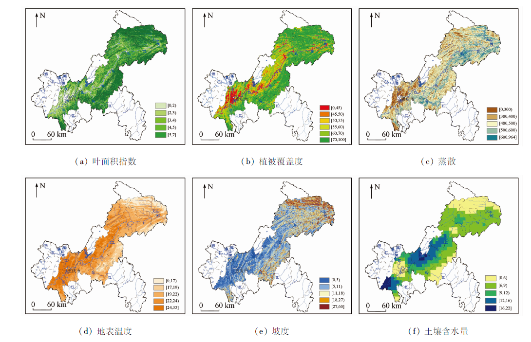
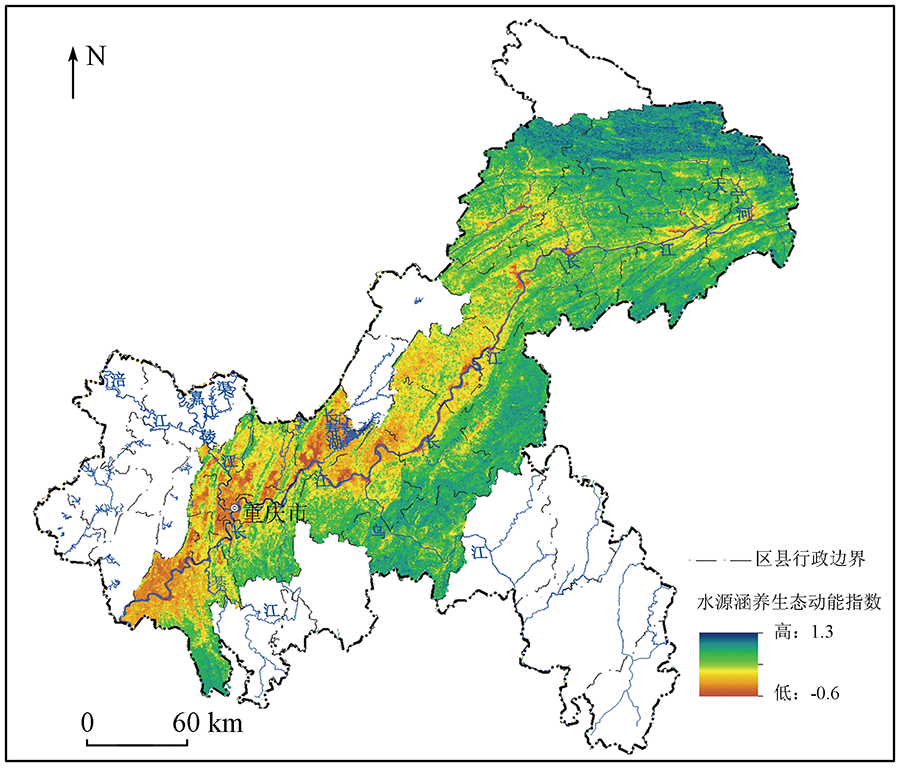
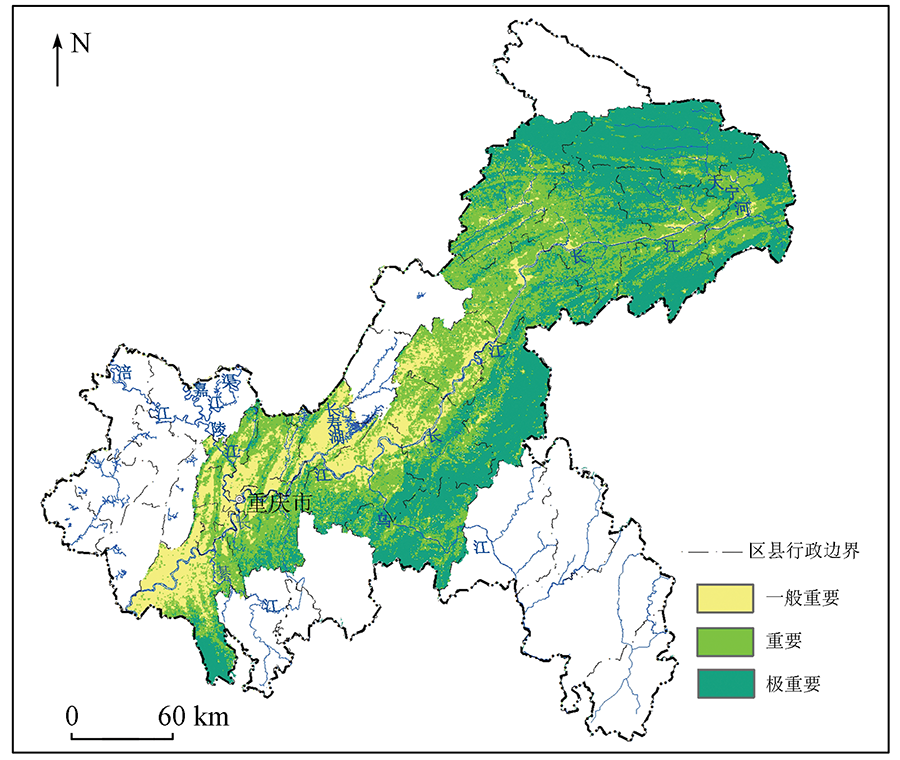
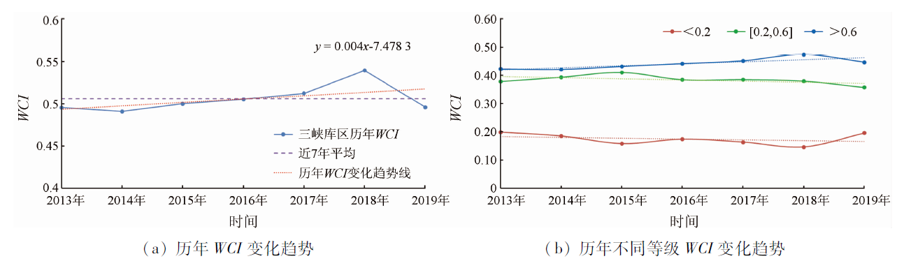
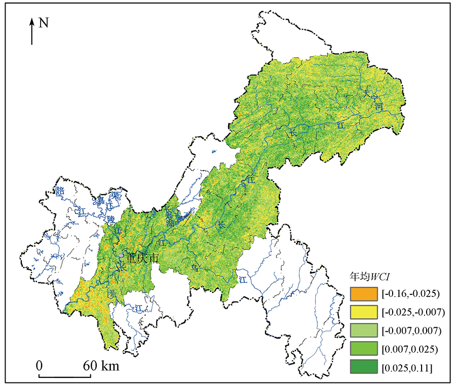
Abstract Water conservation is one of the most important functions of an ecosystem and can maintain and provide water resources for the ecosystem and humans. According to the physical meaning of water conservation, this study used leaf area index, vegetation coverage, and evapotranspiration to represent the water conservation of the vegetation layer and used surface temperature, soil moisture content, and slope to represent the water conservation capacity of the soil layer. Then, this study developed a remote sensing monitoring and evaluation model for water conservation through principal component analysis to explore the spatial-temporal distribution characteristics of the water conservation capacity in the Three Gorges reservoir area. The results show that the water conservation index (WCI) contained the objective information of various indices, could be used to quickly and conveniently assess the water conservation function in the Three Gorges Reservoir area, and properly represented the water conservation capacity there. In 2019, the water conservation capacity was unevenly distributed in the Three Gorges reservoir area and was high downstream and low upstream. The northeastern part of Chongqing was dominated by forest ecosystems and had the strongest water conservation function. From 2013 to 2019, the WCI slightly increased in most areas, especially in some parts of Fengdu, Kaizhou, and Yunyang areas.
|
| Keywords
water conservation
Three Gorges Reservoir area
ecosystem services
remote sensing
|
|
Corresponding Authors:
YANG Shiqi
E-mail: yeqinyu0427@163.com;yangshiqi1980@sina.com
|
|
Issue Date: 20 June 2022
|
|
|
| [1] |
Ball P. Water,water everywhere?[J]. Nature, 2004, 427(6969):19-20.
doi: 10.1038/427019a
url: https://doi.org/10.1038/427019a
|
| [2] |
环境保护部. 生态保护红线划定指南[M]. 北京: 环境保护部, 2015.
|
| [2] |
Ministry of Ecology and Environment of the People’s Republic of China. Ecological protection red line delineated Guide[M]. Beijing: Ministry of Ecology and Environment of the People’s Republic of China, 2015.
|
| [3] |
龚诗涵, 肖洋, 郑华, 等. 中国生态系统水源涵养空间特征及其影响因素[J]. 生态学报, 2017, 37(7):2455-2462.
|
| [3] |
Gong S H, Xiao Y, Zheng H, et al. Spatial patterns of ecosystem water conservation in China and its impact factors analysis[J]. Acta Ecologica Sinica, 2017, 37(7):2455-2462.
|
| [4] |
石培礼, 吴波, 程根伟, 等. 长江上游地区主要森林植被类型蓄水能力的初步研究[J]. 自然资源学报, 2004, 19(3):351-360.
|
| [4] |
Shi P L, Wu B, Cheng G W, et al. Water retention capacity evaluation of main forest vegetation types in the upper Yangtze basin[J]. Journal of Natural Resources, 2004, 19(3):351-360.
|
| [5] |
王升堂, 孙贤斌, 夏韦, 等. 生态系统水源涵养功能的重要性评价——以皖西大别山森林为例[J]. 资源开发与市场, 2019, 35(10):1252-1257.
|
| [5] |
Wang S T, Sun X B, Xia W, et al. Evaluating on significance function of water conservation in forest ecosystem-Taking Dabieshan Mountain in western Anhui Province as an example[J]. Resource Development & Market, 2019, 35(10):1252-1257.
|
| [6] |
Xu J, Xiao Y, Xie G D. Analysis on the spatio-temporal patterns of water conservation services in Beijing[J]. Journal of Resources and Ecology, 2019, 10(4):362-372.
doi: 10.5814/j.issn.1674-764x.2019.04.003
url: https://bioone.org/journals/journal-of-resources-and-ecology/volume-10/issue-4/j.issn.1674-764x.2019.04.003/Analysis-on-the-Spatio-Temporal-Patterns-of-Water-Conservation-Services/10.5814/j.issn.1674-764x.2019.04.003.full
|
| [7] |
李盈盈, 刘康, 胡胜, 等. 陕西省子午岭生态功能区水源涵养能力研究[J]. 干旱区地理, 2015, 38(3):636-642.
|
| [7] |
Li Y Y, Liu K, Hu S, et al. Water conservation function of Ziwuling Ecological Area in Shanxi Province[J]. Arid Land Geography, 2015, 38(3):636-642.
|
| [8] |
程一凡. 基于InVEST模型的三江源国家公园水源涵养量变化与草地生态补偿研究[D]. 云南: 云南财经大学, 2019.
|
| [8] |
Cheng Y F. Study on the change of water conservation capacity and grassland ecological compensation in Sanjianyuan National Park based on InVEST model[D]. Yunnan: Yunnan University of Finance and Economics, 2019.
|
| [9] |
吕乐婷, 任甜甜, 孙才志, 等. 1980—2016年三江源国家公园水源供给及水源涵养功能时空变化研究[J]. 生态学报, 2020, 40(3):993-1003.
|
| [9] |
Lv L T, Ren T T, Sun C Z, et al. Spatial and temporal changes of water supply and water conservation function in Sanjiangyuan National Park from 1980 to 2016[J]. Acta Ecologica Sinica, 2020, 40(3):993-1003.
|
| [10] |
刘菊, 傅斌, 张成虎, 等. 基于InVEST模型的岷江上游生态系统水源涵养量与价值评估[J]. 长江流域资源与环境, 2019, 28(3):577-585.
|
| [10] |
Liu J, Fu B, Zhang C H, et al. Assessment of ecosystem water retention and its value in the upper reaches of Minjiang River based on InVEST model[J]. Resources and Environment in the Yangtze Basin, 2019, 28(3):577-585.
|
| [11] |
李莉, 苏维词, 葛银杰. 重庆市森林生态系统水源涵养功能研究[J]. 水土保持研究, 2015, 22(2):96-100.
|
| [11] |
Li L, Su W C, Ge Y J. Analysis on water conservation capacity of forest ecosystem in Chongqing[J]. Research of Soil and Water Conservation, 2015, 22(2):96-100.
|
| [12] |
潘梅, 陈天伟, 黄麟, 等. 京津冀地区生态系统服务时空变化及驱动因素分析[J]. 生态学报, 2020(15):1-17.
|
| [12] |
Pan M, Chen T W, Huang L, et al. Spatial and temporal variations in ecosystem services and its driving factors analysis in Jing-Jin-Ji region[J]. Acta Ecologica Sinica, 2020(15):1-17.
|
| [13] |
徐涵秋. 区域生态环境变化的遥感评价指数[J]. 中国环境科学, 2013, 33(5):889-897.
|
| [13] |
Xu H Q. A remote sensing index for assessment of regional ecological changes[J]. China Environmental Science, 2013, 33(5):889-897.
|
| [14] |
徐涵秋. 水土流失区生态变化的遥感评估[J]. 农业工程学报, 2013, 29(7):91-97,294.
|
| [14] |
Xu H Q. Assessment of ecological change in soil loss area using remote sensing technology[J]. Transactions of the Chinese Society of Agricultural Engineering, 2013, 29(7):91-97,294.
|
| [15] |
施婷婷, 徐涵秋, 孙凤琴, 等. 建设项目引发的区域生态变化的遥感评估——以敖江流域为例[J]. 生态学报, 2019(18):1-14.
|
| [15] |
Shi T T, Xu H Q, Sun F Q, et al. Remote-sensing-based assessment of regional ecological changes triggered by a construction project:A case study of Aojiang River Watershed[J]. Acta Ecologica Sinica, 2019(18):1-14.
|
| [16] |
杨绘婷, 徐涵秋. 基于遥感空间信息的武夷山国家级自然保护区植被覆盖度变化与生态质量评估[J]. 应用生态学报, 2020, 31(2):533-542.
|
| [16] |
Yang H T, Xu H Q. Assessing fractional vegetation cover changes and ecological quality of the Wuyi Mountain National Nature Reserve based on remote sensing spatial information[J]. Chinese Journal of Applied Ecology, 2020, 31(2):533-542.
|
| [17] |
李月臣, 刘春霞, 闵婕, 等. 三峡库区生态系统服务功能重要性评价[J]. 生态学报, 2013, 33(1):168-178.
|
| [17] |
Li Y C, Liu C X, Min J, et al. RS/GIS based integrated evaluation of the ecosystem services of the Three Gorges Reservoir area (Chongqing section)[J]. Acta Ecologica Sinica, 2013, 33(1):168-178.
doi: 10.5846/stxb201107020989
url: http://www.ecologica.cn/stxb/ch/reader/view_abstract.aspx?file_no=stxb201107020989
|
| [18] |
张德军, 杨世琦, 王永前, 等. 基于GF-1数据的三峡库区水体信息精细化提取[J]. 人民长江, 2019, 50(9):233-239.
|
| [18] |
Zhang D J, Yang S Q, Wang Y Q, et al. Refined water body information extraction of Three Gorges reservoir by using GF - 1 satellite data[J]. Yangtze River, 2019, 50(9):233-239.
|
| [19] |
邓坤枚, 石培礼, 谢高地. 长江上游森林生态系统水源涵养量与价值的研究[J]. 资源科学, 2002, 24(6),68-73.
|
| [19] |
Deng K M, Shi P L, Xie G D. Water conservation of forest ecosystem in the upper reaches of yangtze river and its benefits[J]. Resources Science, 2002, 24(6),68-73.
|
| [20] |
周佳雯, 高吉喜, 高志球, 等. 森林生态系统水源涵养服务功能解析[J]. 生态学报, 2018, 38(5):1679-1686.
|
| [20] |
Zhou J W, Gao J X, Gao Z Q, et al. Analyzing the water conservation service function of the forest ecosystem[J]. Acta Ecologica Sinica, 2018, 38(5):1679-1686.
|
| [21] |
陈姗姗, 刘康, 包玉斌, 等. 商洛市水源涵养服务功能空间格局与影响因素[J]. 地理科学, 2016, 36(10):1546-1554.
doi: 10.13249/j.cnki.sgs.2016.10.012
|
| [21] |
Chen S S, Liu K, Bao Y B, et al. Spatial pattern and influencing factors of water conservation service function in Shangluo City[J]. Scientia Geographica Sinica, 2016, 36(10):1546-1554.
|
| [22] |
李苗苗, 吴炳方, 颜长珍, 等. 密云水库上游植被覆盖度的遥感估算[J]. 资源科学, 2004, 26:153-159.
|
| [22] |
Li M M, Wu B F, Yan C Z, et al. Estimation of vegetation fraction in the upper basin of Miyun Reservoir by remote sensing[J]. Resources Science, 2004, 26:153-159.
|
| [23] |
尹云鹤, 吴绍洪, 赵东升, 等. 过去30年气候变化对黄河源区水源涵养量的影响[J]. 地理研究, 2016, 35(1):49-57.
doi: 10.11821/dlyj201601005
|
| [23] |
Yin Y H, Wu S H, Zhao D S, et al. Ecosystem water conservation changes in response to climate change in the Source Region of the Yellow River from 1981 to 2010[J]. Geographical Research, 2016, 35(1):49-57.
|
| [24] |
李双权, 苏德毕力格, 哈斯, 等. 长江上游森林水源涵养功能及空间分布特征[J]. 水土保持通报, 2011, 31(4):62-67.
|
| [24] |
Li S Q, Su D B L G, Ha S, et al. Water conservation function of forest ecosystem and its spatial distribution characteristics in upper reaches of the yangtze river[J]. Bulletin of Soil and Water Conservation, 2011, 31(4):62-67.
|
| [25] |
Hu W M, Li G, Gao Z H, et al. Assessment of the impact of the Poplar Ecological Retreat Project on water conservation in the Dongting Lake wetland region using the InVEST model[J]. Science of the Total Environment, 2020, 733:1-13.
|
| [26] |
郑培龙, 肖江伟, 吴云, 等. 重庆缙云山典型林分林地土壤贮水特性研究[J]. 水土保持研究, 2006(2):195-197.
|
| [26] |
Zheng P L, Xiao J W, Wu Y, et al. Research on forest soil water retaining properties of typical forests in Jinyun Mountain in Chongqing City[J]. Research of Soil and Water Conservation, 2006(2):195-197.
|
| [27] |
徐建华. 计量地理学[M]. 北京: 高等教育出版社, 2006.
|
| [27] |
Xu J H. Econometric geography[M]. Beijing: Higher Education Press, 2006.
|
| [28] |
曾莉, 李晶, 李婷, 等. 基于贝叶斯网络的水源涵养服务空间格局优化[J]. 地理学报, 2018, 73(9):1809-1822.
doi: 10.11821/dlxb201809015
|
| [28] |
Zeng L, Li J, Li T, et al. Optimizing spatial patterns of water conservation ecosystem service based on Bayesian belief networks[J]. Journal of Geographical Sciences, 2018, 73(9):1809-1822.
|
| [29] |
齐静, 袁兴中, 刘红, 等. 重庆市三峡库区水源涵养重要功能区生态系统服务功能时空演变特征[J]. 水土保持通报, 2015, 35(3):256-260,266,365.
|
| [29] |
Qi J, Yuan X Z, Liu H, et al. Spatio temporal characteristics of ecosystem service in key water resource conservation function area of Three Gorges Area in Chongqing City[J]. Bulletin of Soil and Water Conservation, 2015, 35(3):256-260,266,365.
|
| [30] |
惠刚樱, 王宏翔. 关于森林生态系统服务功能评价的思考[J]. 温带林业研究, 2018, 1(3):5-9.
|
| [30] |
Hui G Y, Wang H X. Consideration on the evaluation of forest ecosystem service function[J]. Journal of Temperate Forestry Research, 2018, 1(3):5-9.
|
| [31] |
顾铮鸣, 金晓斌, 沈春竹, 等. 近15 a江苏省水源涵养功能时空变化与影响因素探析[J]. 长江流域资源与环境, 2018, 27(11):2453-2462.
|
| [31] |
Gu Z M, Jin X B, Shen C Z, et al. Variation and influence factors of water conservation service function in Jiangsu Province from 2000 to 2015[J]. Resources and Environment in the Yangtze Basin, 2018, 27(11):2453-2462.
|
| [32] |
崔景轩, 李秀芬, 郑海峰, 等. 典型气候条件下东北地区生态系统水源涵养功能特征[J]. 生态学报, 2019, 39(9):3026-3038.
|
| [32] |
Cui J X, Li X F, Zheng H F, et al. Spatial analysis of water conservation function in northeast China under different climatic conditions[J]. Acta Ecologica Sinica, 2019, 39(9):3026-3038.
|
| [33] |
环境保护部. 全国生态功能区划(修编版)[M]. 北京: 环境保护部, 2015.
|
| [33] |
Ministry of Ecology and Environment of the People’s republic of china. National ecological function zoning (revised version)[M]. Beijing: Ministry of Ecology and Environment of the People’s Republic of China, 2015.
|
|
Viewed |
|
|
|
Full text
|
|
|
|
|
Abstract
|
|
|
|
|
Cited |
|
|
|
|
| |
Shared |
|
|
|
|
| |
Discussed |
|
|
|
|
 2022,
Vol. 34
2022,
Vol. 34