|
|
 |
|

|
|
|
Evolutionary process and inundation risk identification of water bodies in the beach area of the Yellow River estuary from 1976 to 2020 |
LIU Jiafeng1,2( ), ZHANG Wenkai1(), DU Xiaomin1, JI Xinyang1, YANG Jinzhong1, FAN Jinghui1, SUN Xiyong1, TONG Jing1 ), ZHANG Wenkai1(), DU Xiaomin1, JI Xinyang1, YANG Jinzhong1, FAN Jinghui1, SUN Xiyong1, TONG Jing1 |
1. China Aero Geophysical Survey and Remote Sensing Center for Natural Resources, Beijing 100083, China
2. Open Research Fund Program of Key Laboratory of Digital Mapping and Land Information Application, Minisitry of Natural Resources, Wuhan 430079, China |
|
|
|
|
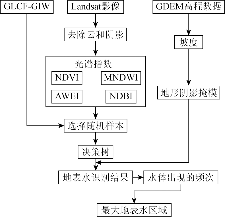
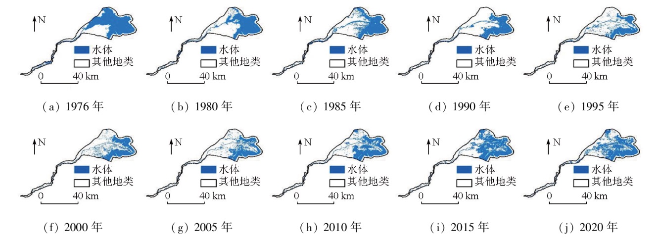
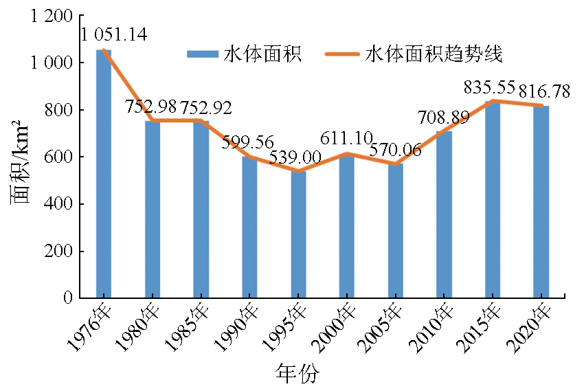
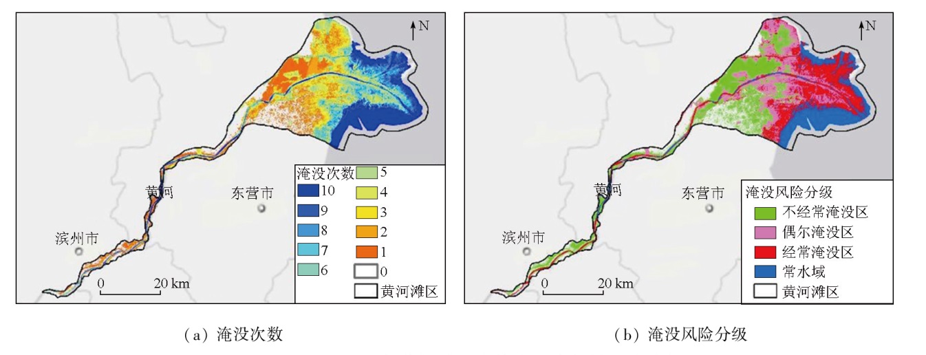
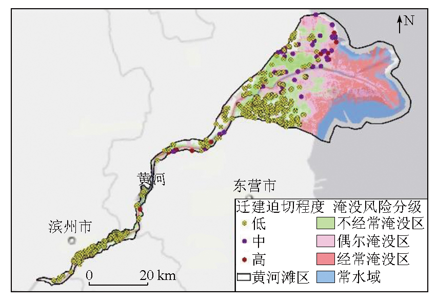
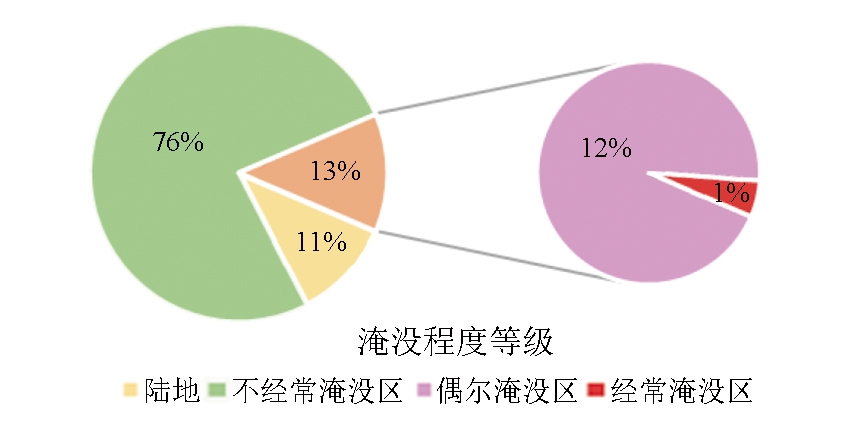
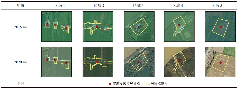
Abstract The ecological protection and high-quality development of the Yellow River basin has become a national strategy. Hence, conducting dynamic monitoring research on the extent of water bodies in the beach area of the Yellow River estuary to avoid potential inundation risks from the evolution of water bodies holds critical significance. Based on the Landsat remote sensing image dataset for wet seasons in the long term, this study extracted the maximum water body extents in the beach area of the Yellow River estuary at 10 time points from 1976 to 2020 using the decision tree-based multi-index land surface water body extraction method. Moreover, this study calculated the historical inundation frequency of each zone through overlay analysis, further identifying the inundation risks of urban and rural settlements and mining land. The findings reveal an area of 463.7 km2 inundated over five times at 10 time points. Among 631 urban and rural settlements and mining land in 2015, 413, 52, and 20 exhibited low, medium, and high inundation risks, respectively. Overall, it is necessary to specify the relocation requirements, scientifically select relocation sites, and improve the infrastructure targeting construction land like urban and rural settlements in the beach area of the Yellow River estuary.
|
| Keywords
Yellow River estuary
Yellow River beach area
remote sensing technology
water body extent
inundation risk
|
|
|
|
Issue Date: 14 June 2024
|
|
|
| [1] |
赵彦伟, 杨志峰, 姚长青. 黄河健康评价与修复基本框架[J]. 水土保持学报, 2005, 19(5):131-134,173.
|
| [1] |
Zhao Y W, Yang Z F, Yao C Q. Basic frameworks of health assessment and restoration of Yellow River[J]. Journal of Soil Water Conservation, 2005, 19(5):131-134,173.
|
| [2] |
方梦阳, 刘晓煌, 孔凡全, 等. 一种基于GEE平台制作逐年土地覆盖数据的方法——以黄河流域为例[J]. 自然资源遥感, 2022, 34(1):135-141.doi:10.6046/zrzyyg.2021088.
|
| [2] |
Fang M Y, Liu X H, Kong F Q, et al. A method for creating annual land cover data based on Google Earth Engine:A case study of the Yellow River Basin[J]. Remote Sensing for Natural Resources, 2022, 34(1):135-141.doi:10.6046/zrzyyg.2021088.
|
| [3] |
杨雯娜, 周亮, 孙东琪. 基于分区-集成的黄河流域生态脆弱性评价[J]. 自然资源遥感, 2021, 33(3):211-218.doi:10.6046/zrzyyg.2020286.
|
| [3] |
Yang W N, Zhou L, Sun D Q. Ecological vulnerability assessment of the Yellow River Basin based on partition-integration concept[J]. Remote Sensing for Natural Resources, 2021, 33(3):211-218.doi:10.6046/zrzyyg.2020286.
|
| [4] |
王薇, 吕宁江, 王昕, 等. 黄河三角洲水土资源空间匹配格局探析[J]. 水资源与水工程学报, 2014, 25(2):66-70.
|
| [4] |
Wang W, Lyu N J, Wang X, et al. Study on spatial matching pattern of water and soil resources in Yellow River delta[J]. Journal of Water Resources and Water Engineering, 2014, 25(2):66-70.
|
| [5] |
李云龙, 孔祥伦, 韩美, 等. 1986—2016年黄河三角洲地表水体变化及其驱动力分析[J]. 农业工程学报, 2019, 35(16):105-113.
|
| [5] |
Li Y L, Kong X L, Han M, et al. Analysis of surface water changes and driving force in Yellow River Delta from 1986 to 2016[J]. Transactions of the Chinese Society of Agricultural Engineering, 2019, 35(16):105-113.
|
| [6] |
王集宁, 蒙永辉, 张丽霞. 近42年黄河口海岸线遥感监测与变迁分析[J]. 国土资源遥感, 2016, 28(3):188-193.doi:10.6046/gtzyyg.2016.03.29.
|
| [6] |
Wang J N, Meng Y H, Zhang L X. Remote sensing monitoring and change analysis of Yellow River Estuary coastline in the past 42 years[J]. Remote Sensing for Land and Resources, 2016, 28(3):188-193.doi:10.6046/gtzyyg.2016.03.29.
|
| [7] |
Peng D, Xiong L, Guo S, et al. Study of Dongting Lake area variation and its influence on water level using MODIS data/Etude de la variation de la surface du Lac Dongting et de son influence sur le niveau d’eau,grâce à des données MODIS[J]. Hydrological Sciences Journal, 2005, 50(1):31-44.
|
| [8] |
Huang S, Li J, Xu M. Water surface variations monitoring and flood hazard analysis in Dongting Lake area using long-term Terra/MODIS data time series[J]. Natural Hazards, 2012, 62(1):93-100.
|
| [9] |
Long Y, Tang R, Wu C, et al. Estimating real-time water area of Dongting Lake using water level information[J]. Water, 2019, 11(6):1240.
|
| [10] |
Yang L, Wang L, Yu D, et al. Four decades of wetland changes in Dongting Lake using Landsat observations during 1978-2018[J]. Journal of Hydrology, 2020, 587:124954.
|
| [11] |
Pekel J F, Cottam A, Gorelick N, et al. High-resolution mapping of global surface water and its long-term changes[J]. Nature, 2016, 540(7633):418-422.
|
| [12] |
Peng Y, He G, Wang G, et al. Surface water changes in Dongting Lake from 1975 to 2019 based on multisource remote-sensing images[J]. Remote Sensing, 2021, 13(9):1827.
|
| [13] |
强海洋, 崔耀平. 黄河滩区综合治理与高质量管护研究[J]. 中国国土资源经济, 2020, 33(5):39-43.
|
| [13] |
Qiang H Y, Cui Y P. Research on comprehensive management and high quality management and protection of the Yellow River beach area[J]. Natural Resource Economics of China, 2020, 33(5):39-43.
|
| [14] |
孙煜航, 杜鹏举, 程舒鹏, 等. 黄河下游宽滩区荒草湿地生境分布与时空变化研究[J]. 人民黄河, 2022, 44(3):85-90.
|
| [14] |
Sun Y H, Du P J, Cheng S P, et al. Study on distribution and spatial-temporal variation of grass wetland habitats along the wide floodplain of the lower Yellow River[J]. Yellow River, 2022, 44(3):85-90.
|
| [15] |
Olshen R A, Breiman L, Friedman J, et al. Classification and regression trees[M]. Newyork: Chapman and Hall, 1984.
|
| [16] |
Hansen M C, Reed B. A comparison of the IGBP DISCover and University of Maryland 1 km global land cover products[J]. International Journal of Remote Sensing, 2000, 21(6/7):1365-1373.
|
| [17] |
Feng M, Sexton J O, Channan S, et al. A global,high-resolution (30-m) inland water body dataset for 2000:First results of a topographic-spectral classification algorithm[J]. International Journal of Digital Earth, 2016, 9(2):113-133.
|
|
Viewed |
|
|
|
Full text
|
|
|
|
|
Abstract
|
|
|
|
|
Cited |
|
|
|
|
| |
Shared |
|
|
|
|
| |
Discussed |
|
|
|
|
 2024,
Vol. 36
2024,
Vol. 36