|
|
 |
|

|
|
|
Estimation of soil organic carbon content in farmland based on UAV hyperspectral images: A case study of farmland in the Huangshui River basin |
SONG Qi1,2,3( ), GAO Xiaohong1,2,3,4(), SONG Yuting1,2,3, LI Qiaoli1,2,3, CHEN Zhen1,2,3, LI Runxiang1,2,3, ZHANG Hao1,2,3, CAI Sangjie1,2,3 ), GAO Xiaohong1,2,3,4(), SONG Yuting1,2,3, LI Qiaoli1,2,3, CHEN Zhen1,2,3, LI Runxiang1,2,3, ZHANG Hao1,2,3, CAI Sangjie1,2,3 |
1. School of Geographical Sciences, Qinghai Normal University, Xining 810008, China
2. Qinghai Province Key Laboratory of Physical Geography and Environmental Process, Xining 810008, China
3. MOE Key Laboratory of Tibetan Plateau Land Surface Processes and Ecological, Xining 810008, China
4. Academy of Plateau Science and Sustainability, Xining 810008, China |
|
|
|
|
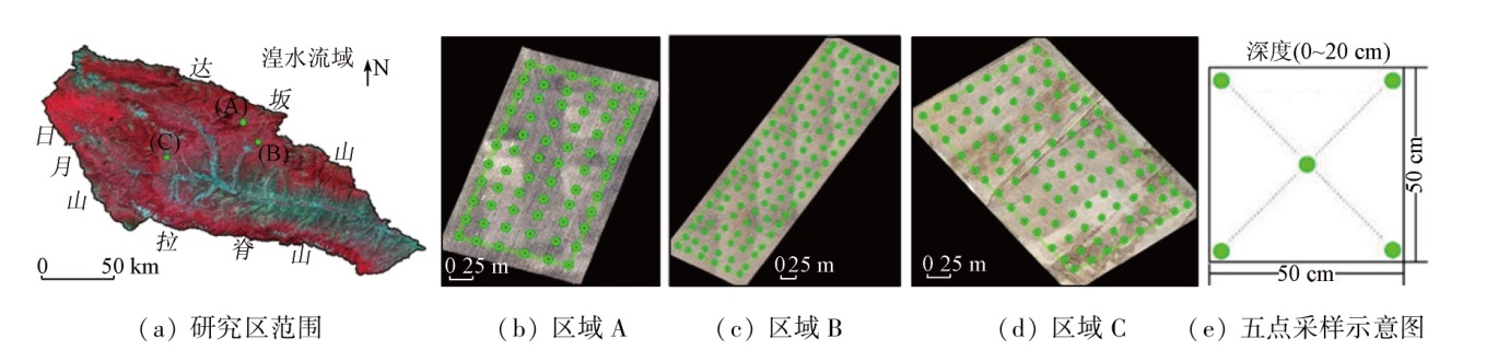
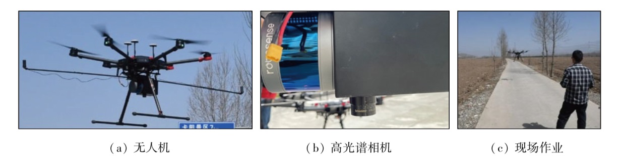
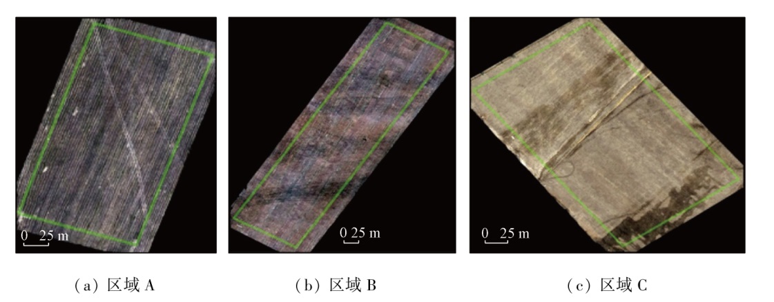
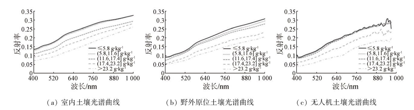
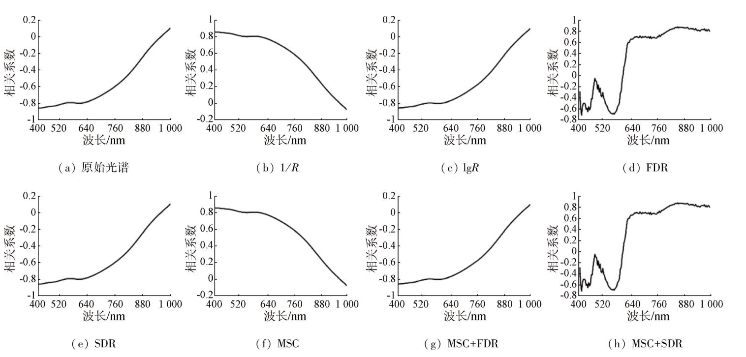
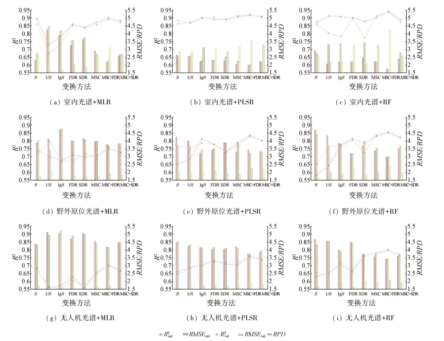
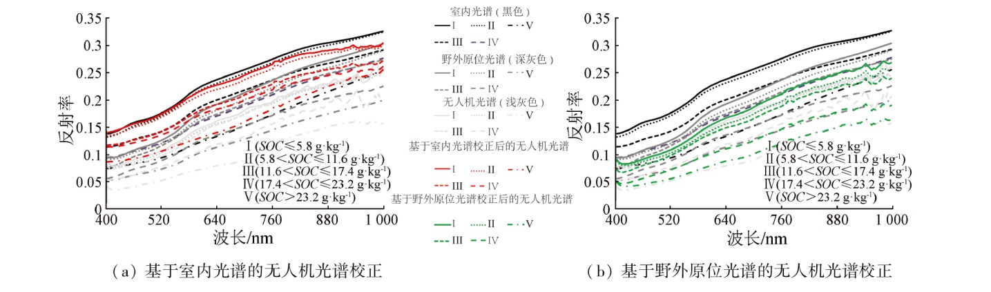
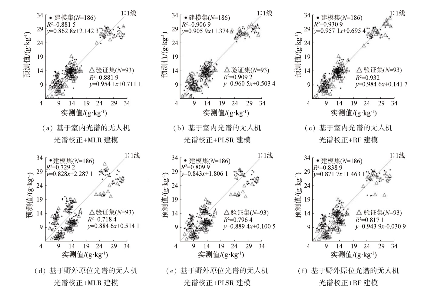
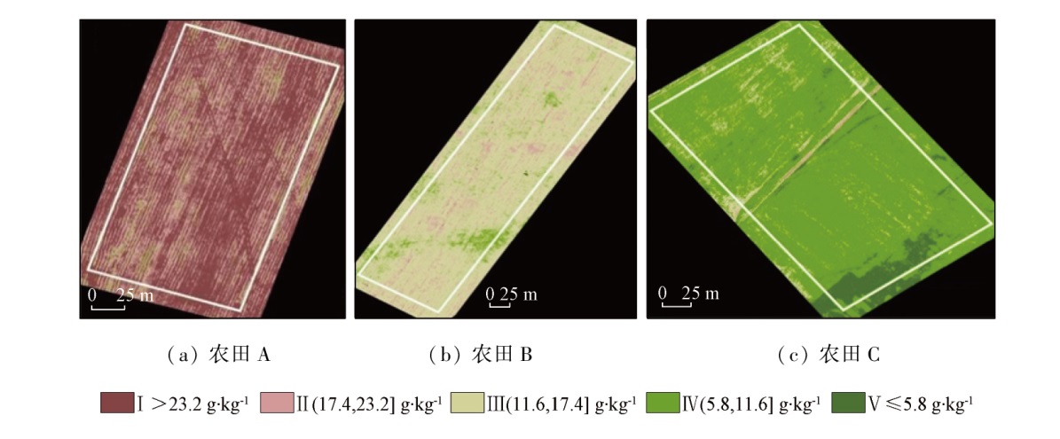
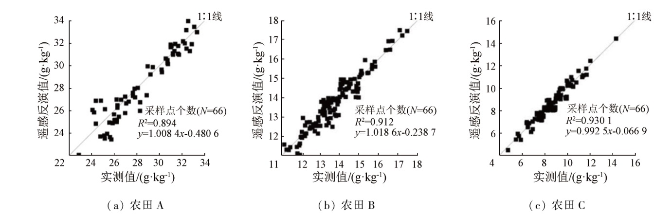
Abstract Rapid and accurate estimation and spatial distribution mapping of soil organic carbon content in farmland facilitate the refined management of soil and the development of smart agriculture. This study investigated three typical farmland areas in the Huangshui River basin of Qinghai Province using 296 soil samples and corresponding field in situ spectra collected synchronously. The unmanned aerial vehicle (UAV) with a hyperspectral camera was employed for image acquisition, and the soil samples were tested for spectral acquisition and organic carbon content in the laboratory. The spectral reflectance was transformed into seven different forms, and the main characteristic bands were screened out through correlation analysis. Using multiple linear regression, partial least squares regression, and random forest, the experimental spectra, field in situ spectra, and UAV spectra were modeled, with the accuracy of the models compared. The UAV spectra were corrected using the direct spectral conversion method, and the optimal model of corrected UAV spectra was used for modeling. The model was substituted into the UAV hyperspectral images for the organic carbon content mapping. Finally, the farmland areas meeting the mapping accuracy requirements were analyzed and discussed. The results show that: ① The multiple linear regression after logarithmic transformation of UAV hyperspectra failed to estimate the organic carbon content, with a relative percent deviation (RPD) of 1.375. Except for it, the experimental spectra, field in situ spectra, and original spectra of UAV hyperspectra as well as all conversion methods could estimate the organic carbon content, with coefficients of determination (R2) ranging from 0.562 to 0.942, root mean square errors (RMSEs) ranging from 1.713 to 5.211. and RPDs between 1.445 and 4.182; ② Among all spectral transformation methods, multiple scatter correction and first-order differential transformation exhibited the highest correlation with the organic carbon content, presenting characteristic bands of 429~449 nm, 498~527 nm, 830~861 nm, and 869 nm; ③ As revealed by the modeling results, the random forest model manifested the highest accuracy, followed by the partial least squares model and the multiple linear regression model in turn. The corrected UAV spectra yielded improved modeling accuracy; ④ The inversion accuracy of the three farmland areas all met the mapping requirements, with R2 values above 0.88. Farmland A exhibited the highest average organic carbon content of 28.88 g·kg-1 and an overall uniform spatial distribution. Farmland B manifested average organic carbon content of 13.52 g·kg-1 and a significantly varying spatial distribution. Farmland C displayed the lowest average organic carbon content of 8.54 g·kg-1 and significant differentiation between high and low values. This study can be referenced for the application of UAV hyperspectral remote sensing technology to the field-scale estimation and digital mapping of soil organic carbon content.
|
| Keywords
unmanned aerial vehicle (UAV)
hyperspectral remote sensing
soil organic carbon
spectral feature selection
spectrum correction
|
|
|
|
Issue Date: 14 June 2024
|
|
|
| [1] |
Li Y W, Duan X W, Li Y, et al. Interactive effects of land use and soil erosion on soil organic carbon in the dry-hot valley region of southern China[J]. Catena, 2021, 201(155):105187.
|
| [2] |
Meng X, Bao Y, Liu J, et al. Regional soil organic carbon prediction model based on a discrete wavelet analysis of hyperspectral satellite data[J]. International Journal of Applied Earth Observation and Geoinformation, 2020, 89:102111.
|
| [3] |
Ge X Y, Ding J L, Teng D X, et al. Exploring the capability of Gaofen-5 hyperspectral data for assessing soil salinity risks[J]. International Journal of Applied Earth Observation and Geoinformation, 2022, 112:102969.
|
| [4] |
Moura-Bueno J M, Dalmolin R S D, Caten A T, et al. Stratification of a local VIS-NIR-SWIR spectral library by homogeneity criteria yields more accurate soil organic carbon predictions[J]. Geoderma, 2019, 337:565-581.
doi: 10.1016/j.geoderma.2018.10.015
|
| [5] |
Soliman A, Heck R, Brenning A, et al. Remote sensing of soil moisture in vineyards using airborne and ground-based thermal inertia data[J]. Remote Sensing, 2013, 5(8):3729-3748.
|
| [6] |
Hu J, Peng J, Zhou Y, et al. Quantitative estimation of soil salinity using UAV-borne hyperspectral and satellite multispectral images[J]. Remote Sensing, 2019, 11(7):736.
|
| [7] |
Sankey J B, Sankey T T, Li J, et al. Quantifying plant-soil-nutrient dynamics in rangelands:Fusion of UAV hyperspectral-LiDAR, UAV multispectral-photogrammetry,and ground-based LiDAR-digital photography in a shrub-encroached desert grassland[J]. Remote Sensing of Environment, 2021, 253:112223.
|
| [8] |
Ge X Y, Ding J L, Jin X L, et al. Estimating agricultural soil moisture content through UAV-based hyperspectral images in the arid region[J]. Remote Sensing, 2021, 13(8):1562.
|
| [9] |
王敬哲, 丁建丽, 马轩凯, 等. 基于光谱指数的绿洲农田土壤含水率无人机高光谱检测[J]. 农业机械学报, 2018, 49(11):164-172.
|
| [9] |
Wang J Z, Ding J L, Ma X K, et al. Detection of soil moisture content based on UAV-derived hyperspectral imagery and spectral index in oasis cropland[J]. Transactions of the Chinese Society for Agricultural Machinery, 2018, 49(11):164-172.
|
| [10] |
祝元丽, 王冬艳, 张鹤, 等. 采用无人机载高分辨率光谱仪反演土壤有机碳含量[J]. 农业工程学报, 2021, 37(6):66-72.
|
| [10] |
Zhu Y L, Wang D Y, Zhang H, et al. Soil organic carbon content retrieved by UAV-borne high resolution spectrometer[J]. Transactions of the Chinese Society of Agricultural Engineering, 2021, 37(6):66-72.
|
| [11] |
葛翔宇, 丁建丽, 王敬哲, 等. 一种基于无人机高光谱影像的土壤墒情检测新方法[J]. 光谱学与光谱分析, 2020, 40(2):602-609.
|
| [11] |
Ge X Y, Ding J L, Wang J Z, et al. A new method for predicting soil moisture based on UAV hyperspectral image[J]. Spectroscopy and Spectral Analysis, 2020, 40(2):602-609.
|
| [12] |
洪永胜, 于雷, 耿雷, 等. 应用DS算法消除室内几何测试条件对土壤高光谱数据波动性的影响[J]. 华中师范大学学报(自然科学版), 2016, 50(2):303-308.
|
| [12] |
Hong Y S, Yu L, Geng L, et al. Using direct standardization algorithm to eliminate the effect of laboratory geometric parameters on soil hyperspectral data fluctuate characteristic[J]. Journal of Central China Normal University (Natural sciences), 2016, 50(2):303-308.
|
| [13] |
Hu Y N, Gao X H, Shen Z Y, et al. Estimation of soil organic matter content based on combined laboratory and field spectroscopy in highland agricultural areas:A case study on the Qinghai-Tibet plateau,China[J]. Fresenius Environmental Bulletin, 2022, 31(1):1561-1575.
|
| [14] |
Ji W J, Shi Z, Huang J Y, et al. In situ measurement of some soil properties in paddy soil using visible and near-infrared spectroscopy[J]. PLoS One, 2014, 9(8):0105708.
|
| [15] |
胡亚男, 高小红, 申振宇, 等. 基于野外实测Vis-NIR光谱的土壤肥力估算研究——以湟水流域为例[J]. 土壤通报, 2021, 52(3):575-584.
|
| [15] |
Hu Y N, Gao X H, Shen Z Y, et al. Estimating fertility index by using field-measured vis-NIR spectroscopy in the Huanghui River basin[J]. Chinese Journal of Soil Science, 2021, 52(3):575-584.
|
| [16] |
闵秀云, 武君, 高春亮, 等. 基于元素分析仪测定土壤有机碳的不同前处理方法对比研究[J]. 盐湖研究, 2020, 28(4):64-70.
|
| [16] |
Min X Y, Wu J, Gao C L, et al. The comparative study on different pretreatment methods of soil organic carbon determined by elemental analyzer[J]. Journal of Salt Lake Research, 2020, 28(4):64-70.
|
| [17] |
Lu L R, Luo J H, Xin Y H, et al. How can UAV contribute in satellite-based phragmites australs aboveground biomass estimating?[J]. International Journal of Applied Earth Observation and Geoinformation, 2022, 114:103024.
|
| [18] |
Zhu C M, Ding J L, Zhang Z P, et al. Exploring the potential of UAV hyperspectral image for estimating soil salinity:Effects of optimal band combination algorithm and random forest[J]. Spectrochimica Acta Part A,Molecular and Biomolecular Spectroscopy, 2022, 279:121416.
|
| [19] |
蔡海辉, 彭杰, 柳维扬, 等. 基于棉田原位高光谱数据的土壤pH值反演与制图研究[J]. 水土保持通报, 2021, 41(4):189-195.
|
| [19] |
Cai H H, Peng J, Liu W Y, et al. Inversion and mapping of soil pH valve based on in-situ hyperspectral data in cotton field[J]. Bulletin of Soil and Water Conservation, 2021, 41(4):189-195.
|
| [20] |
Zhu C M, Ding J L, Zhang Z P, et al. SPAD monitoring of saline vegetation based on Gaussian mixture model and UAV hyperspectral image feature classification[J]. Computers and Electronics in Agriculture, 2022, 200:107236.
|
| [21] |
Chang C W, Laird D A, Mausbach M J, et al. Near-infrared reflectance spectroscopy-principal components regression analyses of soil properties[J]. Soil Science Society of America Journal, 2001, 65(2):480-490.
|
| [22] |
孙肖, 彭军还, 赵锋, 等. 基于空间统计学的高光谱遥感影像主成分选择方法[J]. 自然资源遥感, 2022, 34(2):37-46.doi: 10.6046/zrzyyg.2021214.
|
| [22] |
Sun X, Peng J H, Zhao F, et al. Principal component selection method for hyperspectral remote sensing images based on spatial statistics[J]. Remote Sensing for Natural Resources, 2022, 34(2):37-46.doi: 10.6046/zrzyyg.2021214.
|
| [23] |
孙问娟, 李新举. 煤矿区土壤有机碳含量的高光谱预测模型[J]. 水土保持学报, 2018, 32(5):346-351.
|
| [23] |
Sun W J, Li X J. Hyperspectral prediction model of soil organic carbon content in coal mining area[J]. Journal of Soil and Water Conservation, 2018, 32(5):346-351.
|
| [24] |
陈红艳, 赵庚星, 张晓辉, 等. 去除水分影响提高土壤有机质含量高光谱估测精度[J]. 农业工程学报, 2014, 30(8):91-100.
|
| [24] |
Chen H Y, Zhao G X, Zhang X H, et al. Improving estimation precision of soil organic matter content by removing effect of soil moisture from hyperspectra[J]. Transactions of the Chinese Society of Agricultural Engineering, 2014, 30(8):91-100.
|
| [25] |
Guo L, Fu P, Shi T, et al. Mapping field-scale soil organic carbon with unmanned aircraft system-acquired time series multispectral images[J]. Soil and Tillage Research, 2020, 196:104477.
|
| [26] |
殷彩云, 白子金, 罗德芳, 等. 基于高光谱数据的土壤全氮含量估测模型对比研究[J]. 中国土壤与肥料, 2022(1):9-15.
|
| [26] |
Yin C Y, Bai Z J, Luo D F, et al. Comparative study on estimation models of soil total nitrogen content based on hyperspectral data[J]. Soil and Fertilizer Sciences in China, 2022(1):9-15.
|
| [27] |
纪文君. 基于野外vis-NIR高光谱的土壤属性预测及田间水分影响去除研究[D]. 杭州: 浙江大学, 2014.
|
| [27] |
Ji W J. Removing the effects of soil water and the environment from in situ recorded visible and near-infrared spectra for the prediction of key soil properties in paddy soils[D]. Hangzhou: Zhejiang University, 2014.
|
| [28] |
陈玮, 徐占军, 郭琦. 煤炭矿区耕地土壤有机质无人机高光谱遥感估测[J]. 农业工程学报, 2022, 38(8):98-106.
|
| [28] |
Chen W, Xu Z J, Guo Q. Estimation of soil organic matter by UAV hyperspectral remote sensing in coal mining areas[J]. Transactions of the Chinese Society of Agricultural Engineering, 2022, 38(8):98-106.
|
| [29] |
张东辉, 赵英俊, 秦凯, 等. 光谱变换方法对黑土养分含量高光谱遥感反演精度的影响[J]. 农业工程学报, 2018, 34(20):141-147.
|
| [29] |
Zhang D H, Zhao Y J, Qin K, et al. Influence of spectral transformation methods on nutrient content inversion accuracy by hyperspectral remote sensing in black soil[J]. Transactions of the Chinese Society of Agricultural Engineering, 2018, 34(20):141-147.
|
| [30] |
晏红波, 韦晚秋, 卢献健, 等. 基于高光谱特征的土壤含水量遥感反演方法综述[J]. 自然资源遥感, 2022, 34(2):1-9.doi: 10.6046/zrzyyg.2021126.
|
| [30] |
Yan H B, Wei W Q, Lu X J, et al. A review of remote sensing inversion methods for estimating soil water content based on hyperspectral characteristics[J]. Remote Sensing for Natural Resources, 2022, 34(2):1-9.doi: 10.6046/zrzyyg.2021126.
|
| [31] |
高文龙, 张圣微, 林汐, 等. 煤矿开采中SOM的遥感估算和时空动态分析[J]. 自然资源遥感, 2021, 33(4):235-242.doi: 10.6046/zrzyyg.2020418.
|
| [31] |
Gao W L, Zhang S W, Lin X, et al. The remote sensing-based estimation and spatial-temporal dynamic analysis of SOM in coal mining[J]. Remote Sensing for Natural Resources, 2021, 33(4):235-242.doi: 10.6046/zrzyyg.2020418.
|
| [32] |
李星佑, 张飞, 王筝. 土壤盐渍化遥感监测模型构建方法现状与发展趋势[J]. 自然资源遥感, 2022, 34(4):11-21.doi: 10.6046/zrzyyg.2021395.
|
| [32] |
Li X Y, Zhang F, Wang Z. Present situation and development trend in building remote sensing monitoring models of soil salinization[J]. Remote Sensing for Natural Resources, 2022, 34(4):11-21.doi: 10.6046/zrzyyg.2021395.
|
| [33] |
肖艳, 辛洪波, 王斌, 等. 基于小波变换和连续投影算法的黑土有机质含量高光谱估测[J]. 国土资源遥感, 2021, 33(2):33-39.doi: 10.6046/gtzyyg.2020299.
|
| [33] |
Xiao Y, Xin H B, Wang B, et al. Hyperspectral estimation of black soil organic matter content based on wavelet transform and successive projections algorithm[J]. Remote Sensing for Land and Resources, 2021, 33(2):33-39.doi: 10.6046/gtzyyg.2020299.
|
| [34] |
杨晓宇, 包妮沙, 曹粤, 等. 基于无人机成像光谱技术的农田土壤养分估测及制图[J]. 地理与地理信息科学, 2021, 37(5):38-45.
|
| [34] |
Yang X Y, Bao N S, Cao Y, et al. Estimation and mapping of soil nutrient in farmland based on UAV imaging spectrometry[J]. Geography and Geo-Information Science, 2021, 37(5):38-45.
|
| [35] |
罗德芳, 柳维扬, 彭杰, 等. 土壤水分去除算法的田间原位光谱反演棉田有机质[J]. 光谱学与光谱分析, 2022, 42(1):222-228.
|
| [35] |
Luo D F, Liu W Y, Peng J, et al. Field in situ spectral inversion of cotton organic matter based on soil water removal algorithm[J]. Spectroscopy and Spectral Analysis, 2022, 42(1):222-228.
|
| [36] |
Wang L, Zhang B, Shen Q, et al. Estimation of soil salt and ion contents based on hyperspectral remote sensing data:A case study of Baidunzi basin,China[J]. Water, 2021, 13(4):559.
|
| [37] |
Bai Z J, Xie M D, Hu B F, et al. Estimation of soil organic carbon using Vis-NIR spectral data and spectral feature bands selection in southern Xinjiang,China[J]. Sensors, 2022, 22(16):6124.
|
|
Viewed |
|
|
|
Full text
|
|
|
|
|
Abstract
|
|
|
|
|
Cited |
|
|
|
|
| |
Shared |
|
|
|
|
| |
Discussed |
|
|
|
|
 2024,
Vol. 36
2024,
Vol. 36