|
|
|
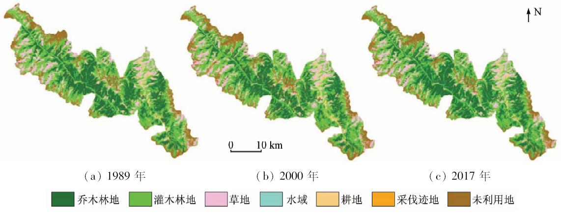
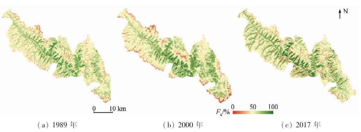
Abstract Monitoring the effectiveness of natural forest protection project (NFPP) is of great significance. In order to know about the changes of natural forest in western Sichuan before and after the implementation of the NFPP, based on the comparative analysis of land cover classification results of Landsat series remote sensing images in 1989, 2000 and 2017, the characteristics of vegetation cover change in western Sichuan natural forest area in recent 29 years were compared and analyzed. The results showed that the vegetation coverage of the natural forest area in western Sichuan was declining as a whole before the NFPP from 1989 to 2000, and it showed a slow rising trend after the projection from 2000 to 2017. The vegetation coverage area which were middle grade and above decreased 6 291.56 hm 2 before the projection and 4 384.01 hm 2 increased after that. The land cover types in the study area in the last 29 years were dominated by arbor forest and shrub forest, and the area transfer occurred mainly between them. In the past 29 years, the change of farmland area was obvious, which increased before the NFPP and decreased after that. In the last 29 years, the forest coverage rate in the study area was rapidly decreasing at first and then slowly increasing. The rate dropped to 61.77% from 1989 to 2000, a decrease of 2.57%, then slowly rose to 65.61% from 2000 to 2017, and the increase was 3.84%. The results of the study show that the implementation of the NFPP has been effectively protecting the natural forest resources in western Sichuan.
|
| Keywords
remote sensing technology
natural forest of western Sichuan
vegetation coverage
natural forest protection project (NFPP)
|
|
|
|
Corresponding Authors:
Wunian YANG
E-mail: ywn@cdut.edu.cn
|
|
Issue Date: 07 December 2018
|
|
|
| [1] |
Bonan G B . Forests and climate change:Forcings,feedbacks,and the climate benefits of forests[J]. Science. 2008,320:1444-1449.
doi: 10.1126/science.1155121
url: http://www.sciencemag.org/cgi/doi/10.1126/science.1155121
|
| [2] |
王兴昌, 王传宽 . 森林生态系统碳循环的基本概念和野外测定方法评述[J]. 生态学报, 2015,35(13):4241-4256.
doi: 10.5846/stxb201407011359
url: http://d.wanfangdata.com.cn/Periodical/stxb201513001
|
| [2] |
Wang X C, Wang C K . Fundamental concepts and field measurement methods of carbon cycling in forest ecosystems:A review[J]. Acta Ecologica Sinica, 2015,35(13):4241-4256.
|
| [3] |
谢馨瑶, 李爱农, 靳华安 . 大尺度森林碳循环过程模拟模型综述[J]. 生态学报, 2018,38(1):41-54.
|
| [3] |
Xie X Y, Li A N, Jin H A . The simulation models of the forest carbon cycle on a large scale:A review[J]. Acta Ecologica Sinica, 2018,38(1):41-54.
|
| [4] |
敖特根其木格, 秦富仓, 周佳宁 , 等. 内蒙古自治区多伦县不同林地枯落物持水性能研究[J]. 水土保持通报, 2017,37(4):114-118.
doi: 10.13961/j.cnki.stbctb.2017.04.019
url: http://d.wanfangdata.com.cn/Periodical/stbctb201704019
|
| [4] |
Aotegenqimuge, Qin F C, Zhou J N , et al. Different forest litters water-holding performance in Duolun County of Inner Mongolia Autonomous Region[J]. Bulletin of Soil and Water Conservation, 2017,37(4):114-118.
|
| [5] |
马维玲, 石培礼, 宗宁 , 等. 太行山区主要森林生态系统水源涵养能力[J]. 中国生态农业学报, 2017,25(4):478-489.
doi: 10.13930/j.cnki.cjea.160786
url: http://www.cqvip.com/QK/97771X/201704/7000161789.html
|
| [5] |
Ma W L, Shi P L, Zong N , et al. Water conservation capacity of forest ecosystems in Taihang Mountain[J]. Chinese Journal of Eco-Agriculture, 2017,25(4):478-489.
|
| [6] |
周彬, 余新晓, 陈丽华 , 等. 基于InVEST模型的北京山区土壤侵蚀模拟[J]. 水土保持研究, 2010,17(6):9-13.
|
| [6] |
Zhou B, Yu X X, Chen L H , et al. Soil erosion simulation in mountain areas of Beijing based on InVEST model[J]. Research of Soil and Water Conservation, 2010,17(6):9-13.
|
| [7] |
闫思宇, 王景燕, 龚伟 , 等. 川南山地林分变化对土壤物理性质和抗蚀性的影响[J]. 长江流域资源与环境, 2016,25(7):1112-1120.
doi: 10.11870/cjlyzyyhj201607013
url: http://d.wanfangdata.com.cn/Periodical/cjlyzyyhj201607013
|
| [7] |
Yan S Y, Wang J Y, Gong W , et al. Effects of forest change on soil physical properties and anti-erodibility in southern Sichuan Mountains[J]. Resources and Environment in the Yangtze Basin, 2016,25(7):1112-1120.
|
| [8] |
崔高阳, 陈云明, 曹扬 , 等. 陕西省森林生态系统碳储量分布格局分析[J]. 植物生态学报, 2015,39(4):333-342.
doi: 10.17521/cjpe.2015.0032
url: http://d.wanfangdata.com.cn/Periodical/zwstxb201504003
|
| [8] |
Cui G Y, Chen Y M, Cao Y , et al. Analysis on carbon stock distribution patterns of forest ecosystems in Shaanxi Province[J]. Chinese Journal of Plant Ecology, 2015,39(4):333-342.
|
| [9] |
张克胜, 尚晴, 刘彦春 , 等. 中国不同气候带人工林与天然林的土壤呼吸差异[J]. 生态科学, 2017,36(6):49-56.
doi: 10.14108/j.cnki.1008-8873.2017.06.007
url: http://d.wanfangdata.com.cn/Periodical/stkx201706007
|
| [9] |
Zhang K S, Shang Q, Liu Y C , et al. Differences in soil respiration between plantation and natural forest among different climate zones in China[J]. Ecological Science, 2017,36(6):49-56.
|
| [10] |
何芳兰, 徐先英, 尉秋实 , 等. 祁连山青海云杉人工林与天然林群落结构特征及物种多样性比较研究[J]. 西北林学院学报, 2016,31(5):1-7.
|
| [10] |
He F L, Xu X Y, Wei Q S , et al. A study on the comparison of community structural characteristics and species diversity between plantations and natural forests of Picea Crassifolia in Qilian Mountains[J]. Journal of Northwest Forestry University, 2016,31(5):1-7.
|
| [11] |
刘世荣, 马姜明, 缪宁 . 中国天然林保护、生态恢复与可持续经营的理论与技术[J]. 生态学报, 2015,35(1):212-218.
|
| [11] |
Liu S R, Ma J M, Miao N . Achievements in natural forest protection, ecological restoration, and sustainable management in China[J]. Acta Ecologica Sinica, 2015,35(1):0212-0218.
|
| [12] |
陶蕴之, 吕一河, 李凤全 , 等. 西南天然林保护工程区生态成效评估[J]. 生态与农村环境学报, 2016,32(5):716-723.
doi: 10.11934/j.issn.1673-4831.2016.05.005
url: http://d.wanfangdata.com.cn/Periodical/ncsthj201605005
|
| [12] |
Tao Y Z, Lyu Y H, Li F Q , et al. Assessment of ecological effect of the natural forest protection project in Southwest China[J]. Journal of Ecology and Rural Environment, 2016,32(5):716-723.
|
| [13] |
贾治邦 . 中国森林资源报告:第七次全国森林资源清查[M]. 北京: 中国林业出版社, 2009: 17-18.
|
| [13] |
Jia Z B. China’s Forest Resources Report:The Seventh National Forest Inventory[M]. Beijing: China Forestry Publishing House, 2009: 17-18.
|
| [14] |
刘彬, 杨万勤, 吴福忠 . 亚高山森林生态系统过程研究进展[J]. 生态学报, 2010,30(16):4476-4483.
url: http://d.wanfangdata.com.cn/Periodical/stxb201016025
|
| [14] |
Liu B, Yang W Q, Wu F Z . Advances in the subalpine forest ecosystem processes[J]. Acta Ecologica Sinica, 2010,30(16):4476-4483.
|
| [15] |
刘纪远 . 中国资源环境遥感宏观调查与动态研究[M]. 北京: 中国科学技术出版社, 1996.
|
| [15] |
Liu J Y. Remote Sensing Macroscopic Investigation and Dynamic Research of China’s Resources and Environment[M]. Beijing: Chinese Science and Technology Press, 1996.
|
| [16] |
Gitelson A A, Kaufman Y J, Stark R , et al. Novel algorithms for remote estimation of vegetation fraction[J]. Remote Sensing of Environment, 2002,80(1):76-87.
doi: 10.1016/S0034-4257(01)00289-9
url: http://linkinghub.elsevier.com/retrieve/pii/S0034425701002899
|
| [17] |
张学玲, 张莹, 牛德奎 , 等. 基于TM NDVI的武功山山地草甸植被覆盖度时空变化研究[J]. 生态学报, 2017,38(7):2414-2424.
|
| [17] |
Zhang X L, Zhang Y, Niu D K , et al. Spatial-temporal dynamics of upland meadow coverage on Wugong Mountain based on TM NDVI[J]. Acta Ecologica Sinica, 2018,38(7):2414-2424.
|
| [18] |
田超, 马祥庆, 王文辉 , 等. 吉林省东部地区植被覆盖度变化及影响因子[J]. 福建农林大学学报(自然科学版), 2017,46(4):410-417.
|
| [18] |
Tian C, Ma X Q, Wang W H , et al. Vegetation cover changes and its influence factors in eastern Jilin Province[J]. Journal of Fujian Agriculture and Forestry University (Natural Science Edition), 2017,46(4):410-417.
|
| [19] |
郑朝菊, 曾源, 赵玉金 , 等. 近15年中国西南地区植被覆盖度动态变化[J]. 国土资源遥感, 2017,29(3):128-136.doi: 10.6046/gtzyyg.2017.03.19.
doi: 10.6046/gtzyyg.2017.03.19
url: http://www.cqvip.com/QK/91397X/201703/673278168.html
|
| [19] |
Zheng Z J, Zeng Y, Zhao Y J , et al. Monitoring and dynamic analysis of fractional vegetation cover in southwestern China over the past 15 years based on MODIS data[J]. Remote Sensing for Land and Resources, 2017,29(3):128-136.doi: 10.6046/gtzyyg.2017.03.19.
|
| [20] |
闫敏, 李增元, 陈尔学 , 等. 蒙古大兴安岭根河森林保护区植被覆盖度变化[J]. 生态学杂志, 2016,35(2):508-515.
|
| [20] |
Yan M, Li Z Y, Chen E X , et al. Vegetation fractional coverage change in Daxinganling Genhe forest reserve of Inner Mongolia[J]. Chinese Journal of Ecology, 2016,35(2):508-515.
|
| [21] |
朱会利, 杨改河, 韩磊 . 延安市退耕过程植被覆盖度变化及其影响因子分析[J]. 农业机械学报, 2015,46(8):272-280.
doi: 10.6041/j.issn.1000-1298.2015.08.038
url: http://d.wanfangdata.com.cn/Periodical/nyjxxb201508038
|
| [21] |
Zhu H L, Yang G H, Han L . Analysis of fractional vegetation coverage changes and its influence factors during farmland returned to forest period in Yan’an City[J]. Transactions of the Chinese Society for Agricultural Machinery, 2015,46(8):272-280.
|
| [22] |
王文辉, 马祥庆, 邹显花 , 等. 2000—2010年福建省植被覆盖度的时空演变特征[J]. 水土保持研究, 2017,24(4):234-239.
url: http://d.wanfangdata.com.cn/Periodical/stbcyj201704039
|
| [22] |
Wang W H, Ma X Q, Zou X H , et al. Spatiotemporal variations of vegetation change in Fujian Province from 2000 to 2010[J]. Research of Soil and Water Conservation, 2017,24(4):234-239.
|
| [23] |
Qi J, Marsett R C, Moran M S , et al. Spatial and temporal dynamics of vegetation in the San Pedro River basin area[J]. Agricultural and Forest Meteorology, 2000,( 105):55-68.
doi: 10.1016/S0168-1923(00)00195-7
url: http://www.sciencedirect.com/science/article/pii/S0168192300001957
|
| [24] |
苗正红, 刘志明, 王宗明 , 等. 基于MODIS NDVI的吉林省植被覆盖度动态遥感监测[J]. 遥感技术与应用, 2010,25(3):387-393.
|
| [24] |
Miao Z H, Liu Z M, Wang Z M , et al. Dynamic monitoring of vegetation fraction change in Jilin Province based on MODIS NDVI[J]. Remote Sensing Technology and Application, 2010,25(3):387-393.
|
| [25] |
张严俊, 丁建丽, 张飞 , 等. 马雷绿洲植被覆盖度时空变化特征及与气候因子的关系[J]. 中国农业大学学报, 2013,18(5):62-68.
|
| [25] |
Zhang Y J, Ding J L, Zhang F , et al. Spatial differences of variations of vegetation coverage and the relationship with climatic factors in Bayramaly Oasis[J]. Journal of China Agricultural University, 2013,18(5):62-68.
|
| [26] |
赵英时 . 遥感应用分析原理与方法[M]. 北京: 科学出版社, 2002, 372-387.
|
| [26] |
Zhao Y S. Principle and Method of Remote Sensing Application Analysis[M]. Beijing: Science Press, 2002, 372-387.
|
| [27] |
李苗苗, 吴炳方, 颜长珍 , 等. 密云水库上游植被覆盖度的遥感估算[J]. 资源科学, 2004,26(4):153-159.
doi: 10.3321/j.issn:1007-7588.2004.04.022
url: http://www.cqvip.com/Main/Detail.aspx?id=10348249
|
| [27] |
Li M M, Wu B F, Yan C Z , et al. Estimation of vegetation fraction in the upper basin of Miyun Reservoir by remote sensing[J]. Resources Science, 2004,26(4):153-159.
|
| [28] |
叶娇珑, 何政伟, 翁中银 , 等. NDVI像元二分模型在喀斯特地区提取石漠化中的应用[J].地理空间信息, 2012(4):134-136.
|
| [28] |
Ye J L, He Z W, Weng Z Y , et al. Application of NDVI pixel binary model in extraction of rocky desertification in Karst areas[J].Geospatial Information,2012(4):134-136.
|
| [29] |
周兆叶, 储少林, 王志伟 , 等. 基于NDVI的植被覆盖度的变化分析——以甘肃省张掖市甘州区为例[J]. 草业科学, 2008,25(12):23-29.
|
| [29] |
Zhou Z Y, Chu S L, Wang Z W , et al. Analysis of vegetation coverage change based on NDVI:A case study in Ganzhou Area, Zhangye City,Gansu[J]. Pratacultural Science, 2008,25(12):23-29.
|
| [30] |
张宇婷, 张振飞, 张志 . 新疆大南湖荒漠区1992—2014年间植被覆盖度遥感研究[J]. 国土资源遥感, 2018,30(1):187-195.doi: 10.6046/gtzyyg.2018.01.26.
|
| [30] |
Zhang Y T, Zhang Z F, Zhang Z . Remote sensing study of vegetation coverage during the period 1992—2014 in Dananhu desert area,Xinjiang[J]. Remote Sensing for Land and Resources, 2018,30(1):187-195.doi: 10.6046/gtzyyg.2018.01.26.
|
| [31] |
国政, 聂华, 臧润国 . 西南地区天保工程综合效益评价[J]. 安徽农业科学, 2011,39(24):15035-15038.
|
| [31] |
Guo Z, Nie H, Zang R G . Evaluation on comprehensive benefit of natural forest protection project in Southwest China[J]. Journal of Anhui Agricultural Science, 2011,39(24):15035-15038.
|
|
Viewed |
|
|
|
Full text
|
|
|
|
|
Abstract
|
|
|
|
|
Cited |
|
|
|
|
| |
Shared |
|
|
|
|
| |
Discussed |
|
|
|
|
 2018,
Vol. 30
2018,
Vol. 30
 )
)