|
|
|
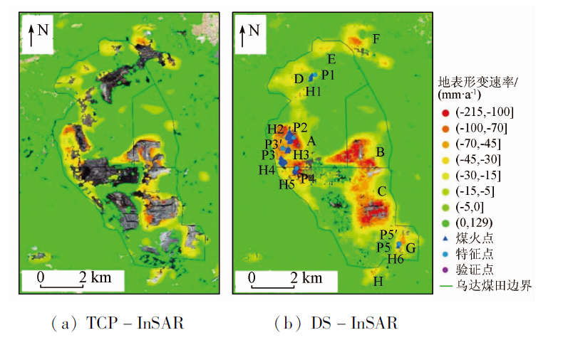
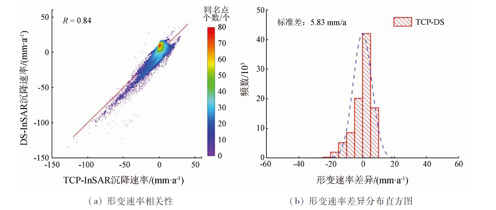
Abstract Coal fire not only wastes a lot of coal resources but also severely damages the ecological environment of the fire area. However, conventional monitoring methods suffer disadvantages such as a small scope, low frequency, high cost, and great danger. Therefore, this study developed a monitoring method of coal field fire based on the distributed scatterer interferometric synthetic aperture Radar (DS-InSAR) technology. This method successively selects homogeneous pixels using the fast statistically homogeneous pixels selection (FaSHPS) algorithm, optimizes the phases of these pixels using the eigenvalue decomposition method, obtains the final distributed targets based on the temporal coherence, and calculates the time-series surface deformation by combining the small baseline subsets (SBAS) InSAR technique. Taking 63 scenes of Sentinel-1A images from March 2017 to April 2019 as the data source, this study obtained the time series surface subsidence in the Wuda coal field using this method and then verified the reliability of the results by comparison with the monitoring results obtained using the temporarily coherent point interferometric synthetic aperture Radar (TCP-InSAR) technology. As a result, the correlation coefficient between the two methods was 0.84, but the density of monitoring sites obtained using the method proposed in this study was 1.24 times higher than that of TCP-InSAR. The monitoring results show that the surface of the Wuda coal field deforms severely, with a maximum deformation rate of -215 mm/a, and that the deformation occurs more rapidly during autumn and winter and has multiple extensional directions and multiple subsidence centers at varying degrees.
|
| Keywords
DS-InSAR
deformation monitoring
coal fire monitoring
long time series
fire area of Wuda coal field
|
|
|
|
Corresponding Authors:
FAN Hongdong
E-mail: lizhu@cumt.edu.cn;cumtfanhd@163.com
|
|
Issue Date: 21 September 2022
|
|
|
| [1] |
Song Z, Kuenzer C, Zhu H, et al. Analysis of coal fire dynamics in the Wuda syncline impacted by fire-fighting activities based on in-situ observations and Landsat8 remote sensing data[J]. International Journal of Coal Geology, 2015,141-142:91-102.
|
| [2] |
Kuenzer C, Zhang J, Sun Y, et al. Coal fires revisited:The Wuda coal field in the aftermath of extensive coal fire research and accelerating extinguishing activities[J]. International Journal of Coal Geology, 2012, 102:75-86
doi: 10.1016/j.coal.2012.07.006
url: https://linkinghub.elsevier.com/retrieve/pii/S0166516212001814
|
| [3] |
Liang Y, Liang H, Zhu S. Mercury emission from coal seam fire at Wuda,Inner Mongolia,China[J]. Atmospheric Environment, 2014, 83:176-184.
doi: 10.1016/j.atmosenv.2013.09.001
url: https://linkinghub.elsevier.com/retrieve/pii/S1352231013006882
|
| [4] |
张志敏, 江利明, 柳林, 等. 利用Landsat热红外影像探测地下煤火区范围——以乌达煤田为例[J]. 测绘通报, 2018(3):93-97.
|
| [4] |
Zhang Z M, Jiang L M, Liu L, et al. Detecting the underground coal fire by using Landsat thermal infrared imagery:Taking Wuda coalfield as an example[J]. Bulletin of Surveying and Mapping, 2018(3):93-97.
|
| [5] |
Du X, Cao D, Mishra D, et al. Self-adaptive gradient-based thresholding method for coal fire detection using ASTER thermal infrared data,part I:Methodology and decadal change detection[J]. Remote Sensing, 2015, 7(6):6576-6610.
doi: 10.3390/rs70606576
url: http://www.mdpi.com/2072-4292/7/6/6576
|
| [6] |
李峰, 梁汉东, 赵小平, 等. 内蒙古乌达煤田煤火治理效果的遥感监测与评估[J]. 国土资源遥感, 2017, 29(3):217-223.doi: 10.6046/gtzyyg.2017.03.32.
doi: 10.6046/gtzyyg.2017.03.32
|
| [6] |
Li F, Liang H D, Zhao X P, et al. Remote sensing monitoring and assessment of fire-fighting effects in Wuda coal field,Inner Mongolia[J]. Remote Sensing for Land and Resources, 2017, 29(3):217-223.doi: 10.6046/gtzyyg.2017.03.32.
doi: 10.6046/gtzyyg.2017.03.32
|
| [7] |
Li F, Li J, Liu X, et al. Coal fire detection and evolution of trend analysis based on CBERS-04 thermal infrared imagery[J]. Environmental Earth Sciences, 2020, 79(16):1-15.
doi: 10.1007/s12665-019-8746-6
url: https://doi.org/10.1007/s12665-019-8746-6
|
| [8] |
蒋卫国, 武建军, 顾磊, 等. 基于夜间热红外光谱的地下煤火监测方法研究[J]. 光谱学与光谱分析, 2011, 31(2):357-361.
|
| [8] |
Jiang W G, Wu J J, Gu L, et al. Monitoring method of undergound coal fire based on nigth thermal infrared remote sensing technology[J]. Spectroscopy and Spectral Analysis, 2011, 31(2):357-361.
|
| [9] |
郑美楠, 邓喀中, 陈华, 等. 时序累积DInSAR与GIS结合的矿区沉降监测与分析[J]. 煤矿安全, 2017, 48(1):160-163.
|
| [9] |
Zheng M N, Deng K Z, Chen H, et al. Monitoring and analysis of mining subsidence base on timing accumulation DInSAR and GIS[J]. Safety in Coal Mines, 2017, 48(1):160-163.
|
| [10] |
赵立峰, 范洪冬, 渠俊峰, 等. 基于DS-InSAR的张双楼煤矿长时序地表形变监测方法[J]. 金属矿山, 2021(8):142-149.
|
| [10] |
Zhao L F, Fan H D, Qu J F, et al. Long time-series surface deformation method of Zhangshuanglou coal mine based on DS-InSAR[J]. Metal Mine, 2021(8):142-149.
|
| [11] |
Voigt S, Tetzlaff A, Zhang J, et al. Integrating satellite remote sensing techniques for detection and analysis of uncontrolled coal seam fires in North China[J]. Elsevier, 2004, 59(1-2):121-136.
|
| [12] |
Xu Y, Fan H, Dang L. Monitoring coal seam fires in Xinjiang using comprehensive thermal infrared and time series InSAR detection[J]. International Journal of Remote Sensing, 2021, 42(6):2220-2245.
doi: 10.1080/01431161.2020.1823045
url: https://www.tandfonline.com/doi/full/10.1080/01431161.2020.1823045
|
| [13] |
Liu J, Wang Y, Yan S, et al. Underground coal fire detection and monitoring based on Landsat8 and Sentinel-1 data sets in Miquan fire area,Xinjiang[J]. Remote Sensing, 2021, 13(6):1141.
doi: 10.3390/rs13061141
url: https://www.mdpi.com/2072-4292/13/6/1141
|
| [14] |
许怡, 范洪冬, 党立波. 基于TIRS和TCP-InSAR的新疆广域煤田火区探测方法[J]. 金属矿山, 2019(10):164-171.
|
| [14] |
Xu Y, Fan H D, Dang L B. Detection method of fire area in Xinjiang wide area coalfield based on TIRS and TCP-InSAR[J]. Metal Mine, 2019(10):164-171.
|
| [15] |
Liu J, Wang Y, Li Y, et al. Underground coal fires identification and monitoring using time-series InSAR with persistent and distributed scatterers:A case study of Miquan coal fire zone in Xinjiang,China[J]. IEEE Access, 2019, 7:164492-164506.
doi: 10.1109/ACCESS.2019.2952363
url: https://ieeexplore.ieee.org/document/8894356/
|
| [16] |
Riyas M, Syed T, Kumar H, et al. Detecting and analyzing the evolution of subsidence due to coal fires in Jharia coalfield,India using Sentinel-1 SAR data[J]. Remote Sensing, 2021, 13(8):1521.
doi: 10.3390/rs13081521
url: https://www.mdpi.com/2072-4292/13/8/1521
|
| [17] |
Zhou L, Zhang D, Wang J, et al. Mapping land subsidence related to underground coal fires in the Wuda coalfield (Northern China) using a small stack of ALOS PALSAR differential interferograms[J]. Remote Sensing, 2013, 5(3):1152-1176.
doi: 10.3390/rs5031152
url: http://www.mdpi.com/2072-4292/5/3/1152
|
| [18] |
黄昭权, 张登荣, 王帆, 等. 基于差分干涉SAR的煤田火区地表形变监测[J]. 国土资源遥感, 2010, 22(4):85-90.doi: 10.6046/gtzyyg.2010.04.18.
doi: 10.6046/gtzyyg.2010.04.18
|
| [18] |
Huang Z Q, Zhang D R, Wang F, et al. Differential SAR interfero-metry for the monitoring of underground coal spontaneous combustion zone surface deformation[J]. Remote Sensing for Land and Resources, 2010, 22(4):85-90.doi: 10.6046/gtzyyg.2010.04.18.
doi: 10.6046/gtzyyg.2010.04.18
|
| [19] |
Jiang L, Lin H, Ma J, et al. Potential of small-baseline SAR interferometry for monitoring land subsidence related to underground coal fires:Wuda (Northern China) case study[J]. Remote Sensing of Environment, 2011, 115(2):257-268.
doi: 10.1016/j.rse.2010.08.008
url: https://linkinghub.elsevier.com/retrieve/pii/S0034425710002488
|
| [20] |
Ferretti A, Fumagalli A, Novali F, et al. A new algorithm for processing interferometric data-stacks:SqueeSAR[J]. IEEE Transactions on Geoscience and Remote Sensing, 2011, 49(9):3460-3470.
doi: 10.1109/TGRS.2011.2124465
url: http://ieeexplore.ieee.org/document/5765671/
|
| [21] |
Jiang M, Ding X, Hanssen R F, et al. Fast statistically homogeneous pixel selection for covariance matrix estimation for multitemporal InSAR[J]. IEEE Transactions on Geoscience and Remote Sensing, 2014, 53(3):1213-1224.
doi: 10.1109/TGRS.2014.2336237
url: http://ieeexplore.ieee.org/document/6866873/
|
| [22] |
Cao N, Lee H, Jung H C. Mathematical framework for phase-triangulation algorithms in distributed-scatterer interferometry[J]. IEEE Geoscience and Remote Sensing Letters, 2015, 12(9):1838-1842.
doi: 10.1109/LGRS.2015.2430752
url: http://ieeexplore.ieee.org/document/7111268/
|
| [23] |
张建明, 管海晏, 曹代勇, 等. 中国地下煤火研究与治理[M]. 北京: 煤炭工业出版社, 2008:12-21.
|
| [23] |
Zhang J M, Guan H Y, Cao D Y, et al. Underground coal fires in China:Origin,detection,fire-fighting,and prevention[M]. Beijing: China Coal Industry Publishing House, 2018:12-21.
|
|
Viewed |
|
|
|
Full text
|
|
|
|
|
Abstract
|
|
|
|
|
Cited |
|
|
|
|
| |
Shared |
|
|
|
|
| |
Discussed |
|
|
|
|
 2022,
Vol. 34
2022,
Vol. 34
 ), FAN Hongdong1(