|
|
 |
|

|
|
|
InSAR monitoring of 3D surface deformation in Jinchuan mining area, Gansu Province |
YANG Wang1,2,3( ), HE Yi1,2,3(), ZHANG Lifeng1,2,3, WANG Wenhui1,2,3, CHEN Youdong1,2,3, CHEN Yi1,2,3 ), HE Yi1,2,3(), ZHANG Lifeng1,2,3, WANG Wenhui1,2,3, CHEN Youdong1,2,3, CHEN Yi1,2,3 |
1. Faculty of Geomatics, Lanzhou Jiaotong University, Lanzhou 730070, China
2. National-Local Joint Engineering Research Center of Technologies and Applications for National Geographic State Monitoring, Lanzhou 730070, China
3. Gansu Provincial Engineering Laboratory for National Geographic State Monitoring, Lanzhou 730070, China |
|
|
|
|
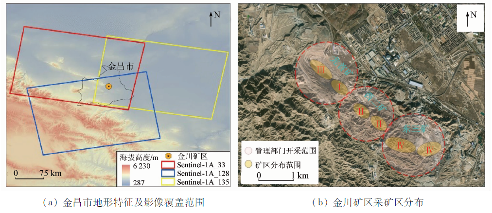
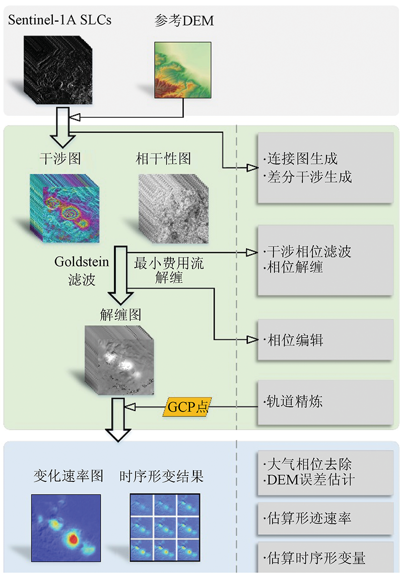
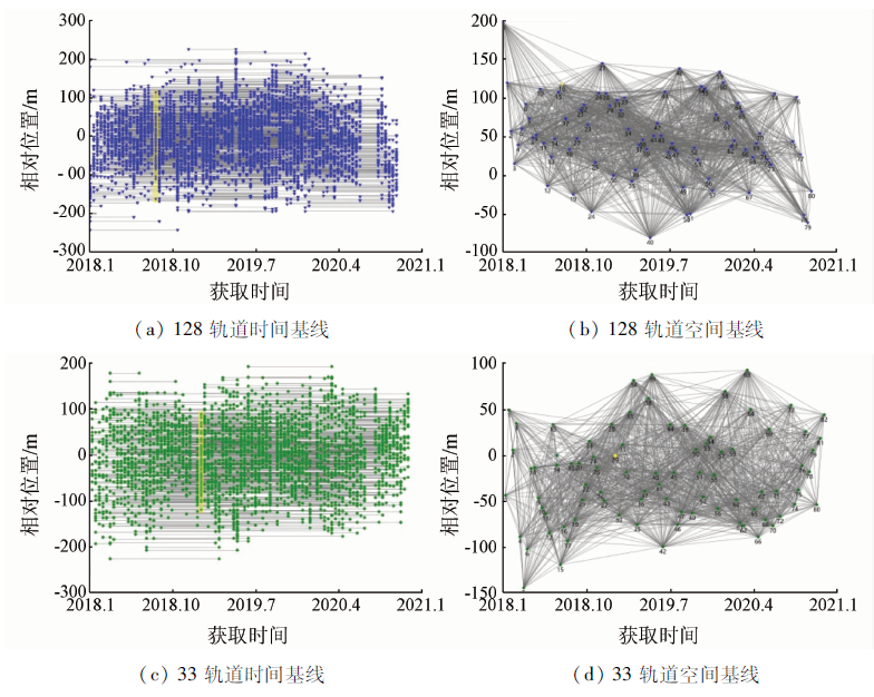
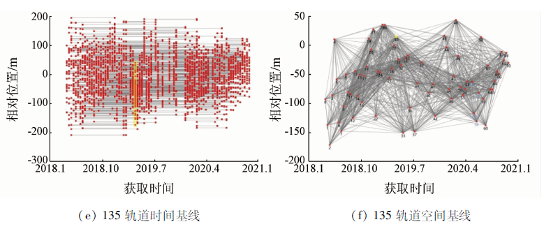
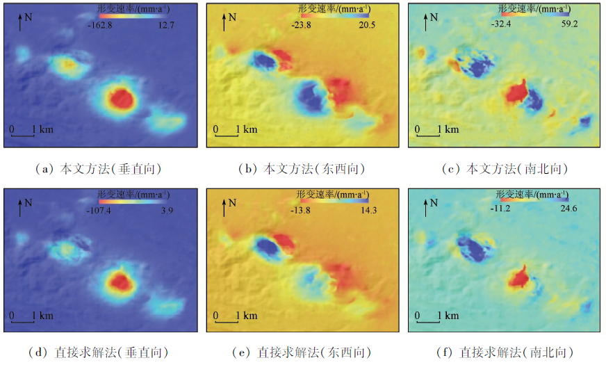
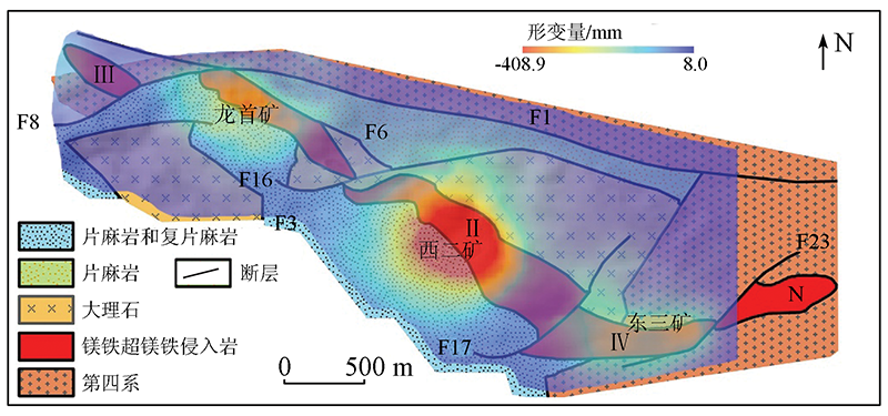
Abstract The Jinchuan mining area is the largest nickel production base in China. However, the surface deformation in the mining area has not been monitored since 2018 when the plan for restoring mining was proposed. Based on the Sentinel-1A data of three orbits (ascending orbit 128 and descending orbits 33 and 135), this study obtained the 3D surface deformation rates and time-series displacement by applying the small baseline subset InSAR (SBAS-InSAR) and the least-squares iterative method combining prior conditions. The results are as follows. Three large deformation areas have formed in three mining areas (i.e., the Longshou, Xi’er, and Dongsan mines). The deformation in these areas is primarily present as surface subsidence, with the maximum vertical subsidence and subsidence rate (i.e., -408.9 mm and -162.8 mm/a, respectively) occurring in the Xi’er Mine. For the Longshou Mine, the southwestern and northeastern slopes contract toward ore veins. For the Xi’er and Dongsan mines, the deformation areas show similar displacement directions, that is, the eastern and western sides of subsidence funnels contract toward ore veins. The surface deformation in the Jinchuan mining area is closely related to man-machine mining, geological faults, and lithologic structures. Among them, man-machine mining is the main cause for the surface deformation, while faults and lithologic structures serve as the controlling factors of the surface deformation. The results of this study will provide theoretical support for safe production and mining planning in the Jinchuan mining area.
|
| Keywords
deformation monitoring
SBAS-InSAR
3D decomposition
Jinchuan mining area
|
|
|
|
Corresponding Authors:
HE Yi
E-mail: 947258095@qq.com;heyi8738@163.com
|
|
Issue Date: 14 March 2022
|
|
|
| [1] |
尹宏杰. 基于InSAR的矿区地表形变监测研究[D]. 长沙:中南大学, 2009.
|
| [1] |
Yin H J. Ground subsidence monitoring in mining area using InSAR[D]. Changsha:Central South University, 2009.
|
| [2] |
中国地质调查局地质环境监测院. 全国矿山地质调查报告[R]. 北京:中国地质调查局, 2016.
|
| [2] |
China Institute of Geo-Enoironmental Monitoring, CGS. National mine geological survey report[R]. Beijing:China Geological Survey, 2016.
|
| [3] |
Siriwardane H J, Amanat J. Analysis of subsidence caused by underground mining[J]. International Journal of Mining Engineering, 1984, 2(4):271-290.
doi: 10.1007/BF00881117
url: http://link.springer.com/10.1007/BF00881117
|
| [4] |
Nie L, Wang H, Xu Y, et al. A new prediction model for mining subsidence deformation:The arc tangent function model[J]. Natural Hazards, 2015, 75(3):2185-2198.
doi: 10.1007/s11069-014-1421-z
url: http://link.springer.com/10.1007/s11069-014-1421-z
|
| [5] |
Hui X, Ma F, Zhao H, et al. Monitoring and statistical analysis of mine subsidence at three metal mines in China[J]. Bulletin of Engineering Geology and the Environment, 2019, 78(6):3983-4001.
doi: 10.1007/s10064-018-1367-6
url: https://doi.org/10.1007/s10064-018-1367-6
|
| [6] |
Chen B, Li Z, Yu C, et al. Three-dimensional time-varying large surface displacements in coal exploiting areas revealed through integration of SAR pixel offset measurements and mining subsidence model[J]. Remote Sensing of Environment, 2020, 240:111663.
doi: 10.1016/j.rse.2020.111663
url: https://linkinghub.elsevier.com/retrieve/pii/S0034425720300328
|
| [7] |
Massonnet D, Feigl K L. Radar interferometry and its application to changes in the Earth’s surface[J]. Reviews of Geophysics, 1998, 36(4):441-500.
doi: 10.1029/97RG03139
url: http://doi.wiley.com/10.1029/97RG03139
|
| [8] |
李勇发, 左小清, 麻源源, 等. 基于PS-InSAR技术和遗传神经网络算法的矿区地表沉降监测与预计[J]. 地球物理学进展, 2020, 35(3):845-851.
|
| [8] |
Li Y F, Zuo X Q, Ma Y Y, et al. Surface subsidence monitoring and prediction based on PS-InSAR and genetic neural network algorithm[J]. Progress in Geophysics, 2020, 35(3):845-851.
|
| [9] |
Simons M, Fialko Y, Rivera L. Coseismic deformation from the 1999 Mw 7.1 Hector Mine,California,earthquake as inferred from InSAR and GPS observations[J]. Bulletin of the Seismological Society of America, 2002, 92(4):1390-1402.
doi: 10.1785/0120000933
url: https://pubs.geoscienceworld.org/bssa/article/92/4/1390-1402/120788
|
| [10] |
Zhao C, Lu Z, Zhang Q, et al. Mining collapse monitoring with SAR imagery data:A case study of Datong mine,China[J]. Journal of Applied Remote Sensing, 2014, 8(1):083574.
doi: 10.1117/1.JRS.8.083574
url: http://remotesensing.spiedigitallibrary.org/article.aspx?doi=10.1117/1.JRS.8.083574
|
| [11] |
Wempen J M, McCarter M K. Comparison of L-band and X-band differential interferometric synthetic aperture Radar for mine subsidence monitoring in central Utah[J]. International Journal of Mining Science and Technology, 2017, 27(1):159-163.
doi: 10.1016/j.ijmst.2016.11.012
url: https://linkinghub.elsevier.com/retrieve/pii/S2095268616301951
|
| [12] |
Carlà T, Farina P, Intrieri E, et al. Integration of ground-based Radar and satellite InSAR data for the analysis of an unexpected slope failure in an open-pit mine[J]. Engineering Geology, 2018, 235:39-52.
doi: 10.1016/j.enggeo.2018.01.021
url: https://linkinghub.elsevier.com/retrieve/pii/S0013795217312826
|
| [13] |
Li J, Gao F, Lu J. An application of InSAR time-series analysis for the assessment of mining-induced structural damage in Panji Mine,China[J]. Natural Hazards, 2019, 97(1):243-258.
doi: 10.1007/s11069-019-03639-8
url: https://doi.org/10.1007/s11069-019-03639-8
|
| [14] |
Ma C, Cheng X, Yang Y, et al. Investigation on mining subsidence based on multi-temporal InSAR and time-series analysis of the small baseline subset:Case study of working faces 22201-1/2 in Bu’ertai mine,Shendong coalfield,China[J]. Remote Sensing, 2016, 8(11):951-975.
doi: 10.3390/rs8110951
url: http://www.mdpi.com/2072-4292/8/11/951
|
| [15] |
Pawluszek-Filipiak K, Borkowski A. Integration of DInSAR and SBAS techniques to determine mining-related deformations using sentinel-1 data:The case study of Rydułtowy mine in Poland[J]. Remote Sensing, 2020, 12(2):242-264.
doi: 10.3390/rs12020242
url: https://www.mdpi.com/2072-4292/12/2/242
|
| [16] |
Torres R, Snoeij P, Geudtner D, et al. GMES Sentinel-1 mission[J]. Remote Sensing of Environment, 2012, 120:9-24.
doi: 10.1016/j.rse.2011.05.028
url: https://linkinghub.elsevier.com/retrieve/pii/S0034425712000600
|
| [17] |
Hu J, Li Z W, Zhu J J, et al. Inferring three-dimensional surface displacement field by combining SAR interferometric phase and amplitude information of ascending and descending path[J]. Science China Earth Sciences, 2010, 53(4):550-560.
doi: 10.1007/s11430-010-0023-1
url: http://link.springer.com/10.1007/s11430-010-0023-1
|
| [18] |
李强. 基于空天地数据集成的甘肃金川矿区地表沉降监测[D]. 绵阳:西南科技大学, 2020.
|
| [18] |
Li Q. Surface subsidence monitoring of Jinchuan mining area in gansu based on space-air-ground integration[D]. Mianyang:Southwest University of Science and Technology, 2020.
|
| [19] |
耿许可. 基于时序InSAR的龙首矿区形变监测研究[D]. 青岛:山东科技大学, 2018.
|
| [19] |
Geng X K. Study of the subsidence-monitoring in dragon head mine area with times series InSAR technology[D]. Qingdao:Shandong University of Science and Technology, 2018.
|
| [20] |
丁宁, 邓清海, 耿许可, 等. 融合时序InSAR与GPS的龙首矿露天矿坑三维变形规律研究[J]. 金属矿山, 2019(10):61-67.
|
| [20] |
Ding N, Deng Q H, Geng X K, et al. Study on the 3D deformation regularity of the open pit in Longshou mine based on time series InSAR technique and GPS[J]. Metal Mine, 2019(10):61-67.
|
| [21] |
张拥军, 杨登峰, 王金涛, 等. 露天边坡局部失稳特征的数值分析及监测[J]. 金属矿山, 2014, 43(10):142-147.
|
| [21] |
Zhang Y J, Yang D F, Wang J T, et al. Numerical analysis and monitoring of local instability characteristics of open pit slope[J]. Metal Mine, 2014, 43(10):142-147.
|
| [22] |
Yang S, Yang G, Qu W, et al. Pt-Os isotopic constraints on the age of hydrothermal overprinting on the Jinchuan Ni-Cu-PGE deposit,China[J]. Mineralium Deposita, 2018, 53(6):757-774.
doi: 10.1007/s00126-017-0775-z
url: https://doi.org/10.1007/s00126-017-0775-z
|
| [23] |
Prichard H M, Knight R D, Fisher P C, et al. Distribution of platinum-group elements in magmatic and altered ores in the Jinchuan intrusion,China:An example of selenium remobilization by postmagmatic fluids[J]. Mineralium Deposita, 2013, 48(6):767-786.
doi: 10.1007/s00126-013-0454-7
url: http://link.springer.com/10.1007/s00126-013-0454-7
|
| [24] |
Wang W, He Y, Zhang L, et al. Analysis of surface deformation and driving forces in Lanzhou[J]. Open Geosciences, 2020, 12(1):1127-1145.
doi: 10.1515/geo-2020-0128
url: https://www.degruyter.com/document/doi/10.1515/geo-2020-0128/html
|
| [25] |
Berardino P, Fornaro G, Lanari R, et al. A new algorithm for surface deformation monitoring based on small baseline differential SAR interferograms[J]. IEEE Transactions on Geoscience and Remote Sensing, 2002, 40(11):2375-2383.
doi: 10.1109/TGRS.2002.803792
url: http://ieeexplore.ieee.org/document/1166596/
|
| [26] |
白泽朝, 汪宝存, 靳国旺, 等. Sentinel-1A数据矿区地表形变监测适用性分析[J]. 自然资源遥感, 2019, 31(2):210-217.doi: 10.6046/gtzyyg.2019.02.29.
doi: 10.6046/gtzyyg.2019.02.29
|
| [26] |
Bai Z C, Wang B C, Jin G W, et al. Applicability analysis of ground deformation monitoring in mining area by Sentinel-1A data[J]. Remote Sensing for Land and Resources, 2019, 31(2):210-217.doi: 10.6046/gtzyyg.2019.02.29.
doi: 10.6046/gtzyyg.2019.02.29
|
| [27] |
Lanari R, Mora O, Manunta M, et al. A small-baseline approach for investigating deformations on full-resolution differential SAR interferograms[J]. IEEE Transactions on Geoscience and Remote Sensing, 2004, 42(7):1377-1386.
doi: 10.1109/TGRS.2004.828196
url: http://ieeexplore.ieee.org/document/1315820/
|
| [28] |
He Y, Chen Y, Wang W, et al. TS-InSAR analysis for monitoring ground deformation in Lanzhou New District,the Loess Plateau of China,from 2017 to 2019[J]. Advances in Space Research, 2021, 67(4):1267-1283.
doi: 10.1016/j.asr.2020.11.004
url: https://linkinghub.elsevier.com/retrieve/pii/S0273117720307869
|
| [29] |
He Y, Wang W, Yan H, et al. Characteristics of surface deformation in Lanzhou with Sentinel-1A TOPS[J]. Geosciences, 2020, 10(3):99-102.
doi: 10.3390/geosciences10030099
url: https://www.mdpi.com/2076-3263/10/3/99
|
| [30] |
王家庆. 2008年改则地震多视角InSAR三维形变场及断层滑动反演[D]. 北京:中国地震局地质研究所, 2015.
|
| [30] |
Wang J Q. The three-dimensional deformation field of the 2008 Gaize Tibet earthquake resolved from InSAR measurements with mult-incidence angle and inversion of fault slip distributions[D]. Beijing:Institute of Geology, China Earthquake Administration, 2015.
|
| [31] |
Wright T J, Parsons B E, Lu Z. Toward mapping surface deformation in three dimensions using InSAR[J]. Geophysical Research Letters, 2004, 31(1):1-5.
|
| [32] |
Peck R B. Deep excavations and tunneling in soft ground[C]// Proc.7th ICSMFE, 1969:225-290.
|
| [33] |
张鹏飞. 基于时序InSAR技术的山区煤矿开采沉陷监测研究[D]. 徐州:中国矿业大学(徐州),2014.
|
| [33] |
Zhang P F. Research on mining subsidence monitoring of mountain coal mine based on time-series InSAR technology[D]. Xuzhou:China University of Mining and Technology(Xuzhou),2014.
|
| [34] |
胡俊. 基于现代测量平差的InSAR三维形变估计理论与方法[D]. 长沙:中南大学, 2013.
|
| [34] |
Hu J. Theory and method of InSAR 3D deformation estimation based on modern measurement adjustment[D]. Changsha:Central South University, 2013.
|
| [35] |
王志伟. 基于多源InSAR数据的三维地表形变解算方法研究[J]. 测绘学报, 2019, 48(9):1206.
|
| [35] |
Wang Z W. Research on 3D surface deformation calculation method based on multi-source InSAR data[J]. Journal of Geomatics and Mapping, 2019, 48(9):1206.
|
| [36] |
祝传广. 融合多源SAR影像的形变监测研究[D]. 徐州:中国矿业大学(徐州),2015.
|
| [36] |
Zhu C G. Research on deformation monitoring based on multi-source SAR image fusion[D]. Xuzhou:China University of Mining and Technology(Xuzhou),2015.
|
| [37] |
刘志敏, 李永生, 张景发, 等. 基于SBAS-InSAR的长治矿区地表形变监测[J]. 自然资源遥感, 2014, 26(3):37-42.doi: 10.6046/gtzyyg.2014.03.06.
doi: 10.6046/gtzyyg.2014.03.06
|
| [37] |
Liu Z M, Li Y S, Zhang J F, et al. An analysis of surface deformation in the Changzhi mining area using small baseline InSAR[J]. Remote Sensing for Land and Resources, 2014, 26(3):37-42.doi: 10.6046/gtzyyg.2014.03.06.
doi: 10.6046/gtzyyg.2014.03.06
|
| [38] |
Li X, Wang S J, Liu T Y, et al. Engineering geology,ground surface movement and fissures induced by underground mining in the Jinchuan nickel mine[J]. Engineering Geology, 2004, 76(1-2):93-107.
doi: 10.1016/j.enggeo.2004.06.008
url: https://linkinghub.elsevier.com/retrieve/pii/S0013795204001309
|
| [39] |
Sun Q, Ma F, Guo J, et al. Deformation failure mechanism of deep vertical shaft in Jinchuan mining area[J]. Sustainability, 2020, 12(6):2226-2248.
doi: 10.3390/su12062226
url: https://www.mdpi.com/2071-1050/12/6/2226
|
|
Viewed |
|
|
|
Full text
|
|
|
|
|
Abstract
|
|
|
|
|
Cited |
|
|
|
|
| |
Shared |
|
|
|
|
| |
Discussed |
|
|
|
|
 2022,
Vol. 34
2022,
Vol. 34