|
|
|
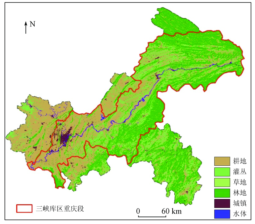
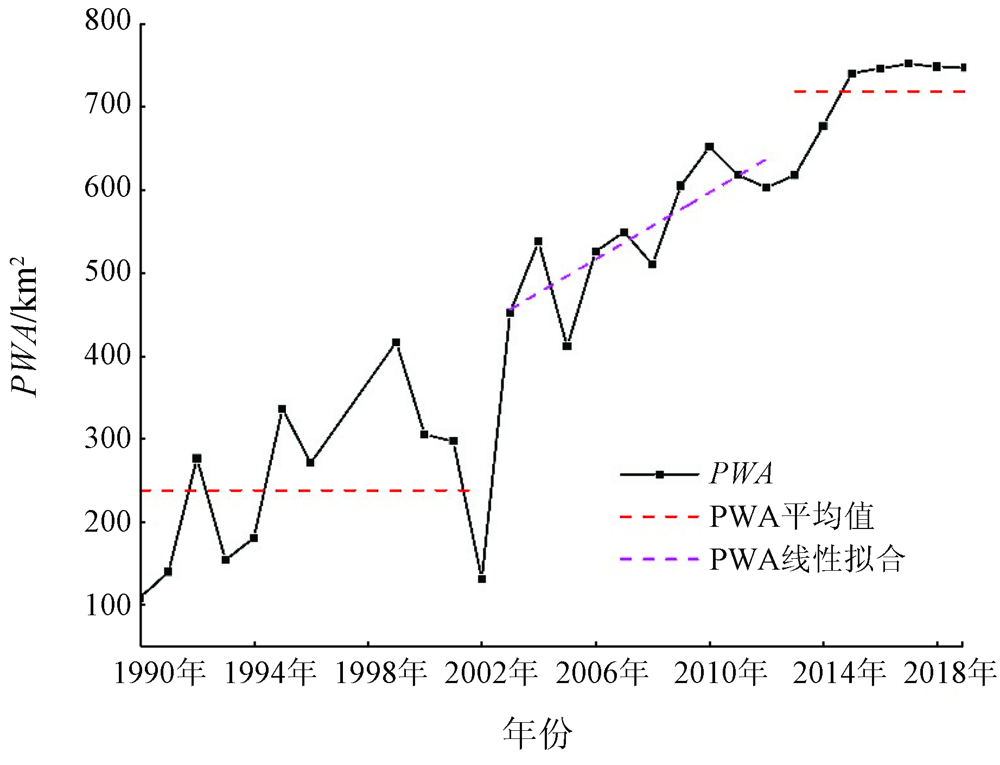
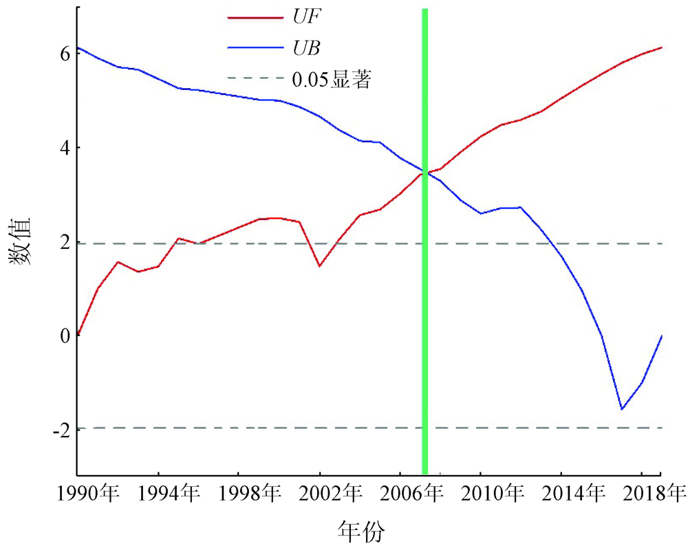
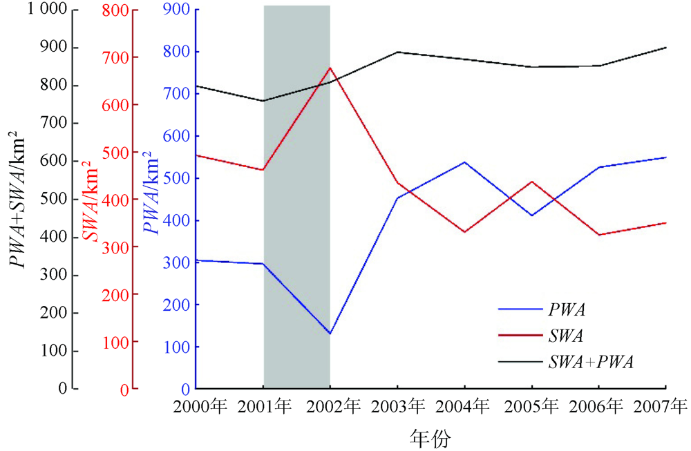
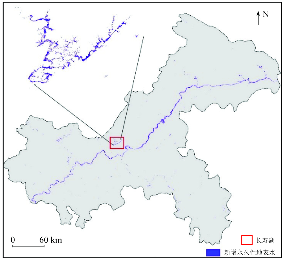
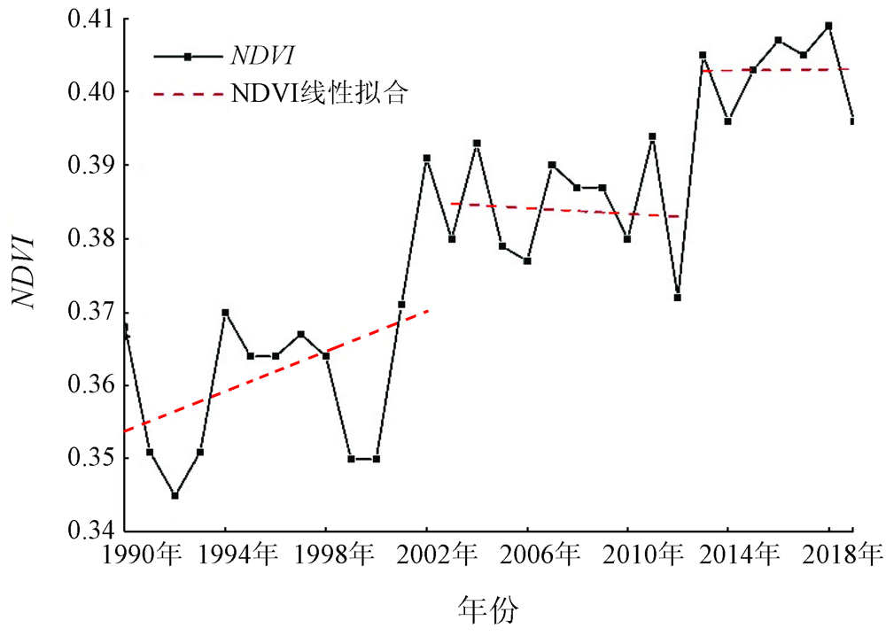
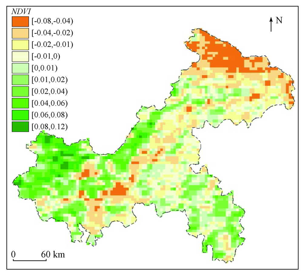
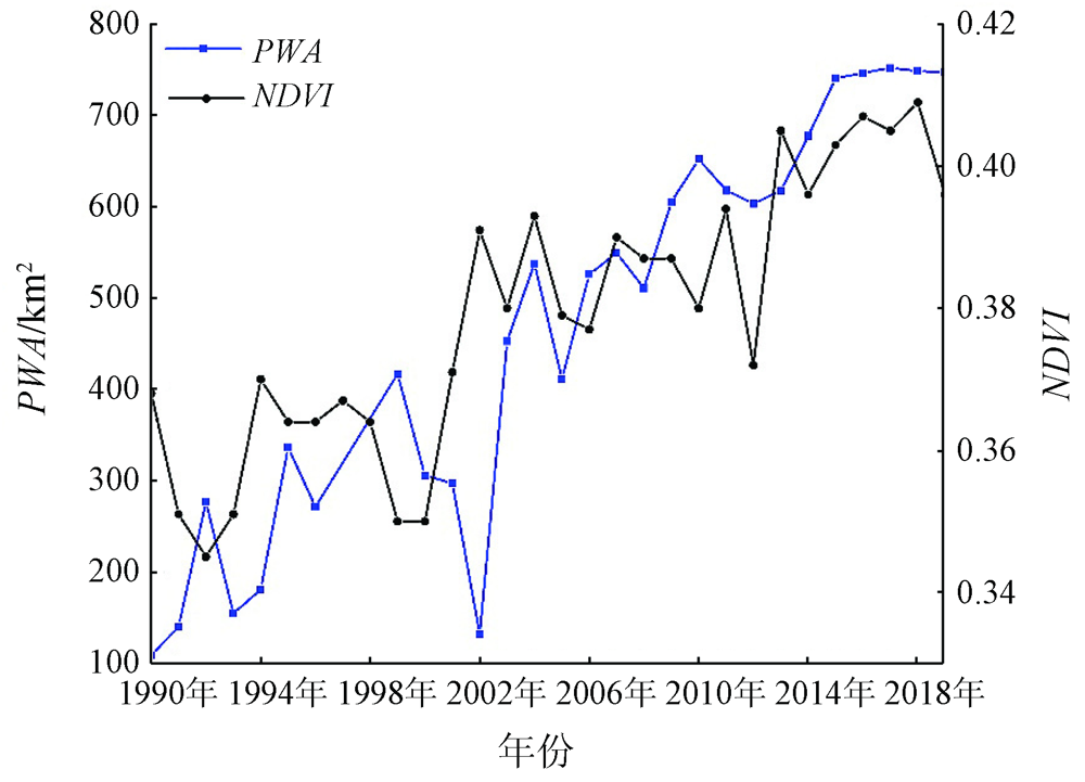
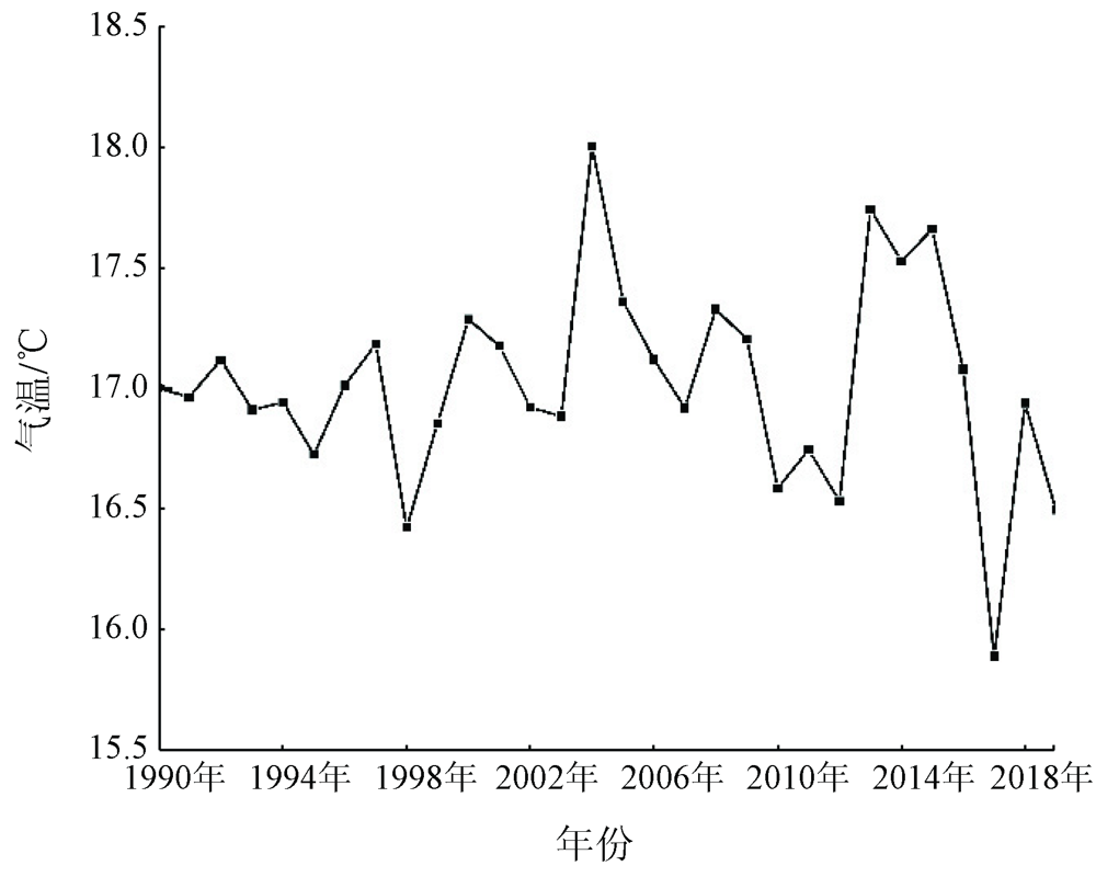
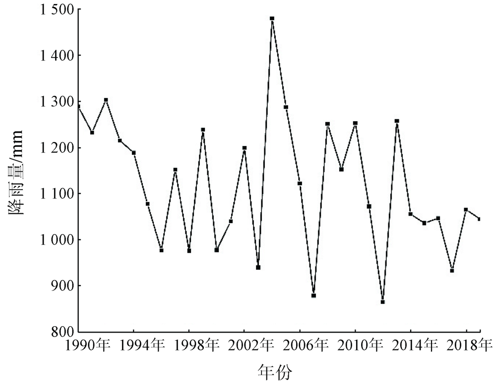
Abstract It is significant for maintaining ecological security to study the impacts of the Three Gorges Dam Project on the surrounding ecological environment. At present, massive studies have revealed the impacts from the construction and water impoundment of the Three Gorges Dam on meteorology, vegetation, land use, and the occurrence of disasters. However, the impacts of the project on surface water-an important part of the Earth’s water resources-are still unclear, especially in the upper reaches of the Yangtze River. Based on multi-source data and the Google Earth Engine platform, this study analyzes the changes in permanent surface water, vegetation, and meteorological factors in the Chongqing area before (1990—2002), during (2003—2012) and after (2013—2019) the water impoundment of Three Gorges Dam Project. The results show: ① Both surface water and vegetation in the study area showed an increasing trend during 1990—2019 with different growth patterns and notably response to the water impoundment. In contrast, the temperature and precipitation continuously fluctuated but did not significantly respond to the water impoundment process during that period. ② The area of the permanent surface water in the study area increased at an annual rate of 18.32 km2 during the water impoundment but did not greatly change before and after the water impoundment. The newly added permanent surface water was mainly distributed along the Yangtze River and its tributaries, especially in the middle part of the Chongqing section of the Yangtze River. Besides, a minority of it was distributed in some lakes and reservoirs. For example, the area of the Changshou lake increased by more than 20% during the water impoundment. ③ The normalized difference vegetation index (NDVI) increased by 18.55% in a stepwise way before, during, and after the water impoundment, which is attributable to joint effects of the increase in surface water and the restoration projects of degraded ecosystem. This study indicates that the water impoundment of the Three Gorges Dam Project has notable impacts on the spatial-temporal dynamics of the water resources in the Chongqing area. Meanwhile, it reveals effective evidence that the water conservancy projects can change the coverage and water resource distribution on the ground surface. All these will provide scientific basis for water resource management in the Chongqing area and even the whole Yangtze River Basin.
|
| Keywords
water impoundment of Three Gorges Dam Project
permanent surface water
Google Earth Engine
Long time series data
multi-source data
|
|
|
|
Corresponding Authors:
HAN Xujun
E-mail: peiyul@email.swu.edu.cn;hanxujun@swu.edu.cn
|
|
Issue Date: 23 December 2021
|
|
|
| [1] |
何军, 张伟, 李家明, 等. 三峡工程建成蓄水对库区参考作物蒸发蒸腾量的影响研究[J]. 中国农村水利水电, 2020(8):122-125.
|
| [1] |
He J, Zhang W, Li J M, et al. Research on the influence of Three Gorges Project construction on reference crop evapotranspiration ET0 in reservoir areas[J]. China Rural Water and Hydropower, 2020(8):122-125.
|
| [2] |
陈鲜艳, 张强, 叶殿秀, 等. 三峡库区局地气候变化[J]. 长江流域资源与环境, 2009,18(1):47-51.
|
| [2] |
Chen X Y, Zhang Q, Ye D X, et al. Regional climate change over Three Gorges Reservoir area[J]. Resources and Environment in the Yangtze Basin, 2009,18(1):47-51.
|
| [3] |
王圆圆, 李贵才, 郭徵, 等. 1979年—2014年三峡库区月平均气温的时空变化分析[J]. 遥感学报, 2018,22(3):487-496.
|
| [3] |
Wang Y Y, Li G C, Guo H, et al. Spatial-temporal analysis of monthly air temperature changes from 1979—2014 in the Three Gorges Dam region[J]. Journal of Remote Sensing, 2018,22(3):487-496.
|
| [4] |
李博, 唐世浩. 基于TRMM卫星资料分析三峡蓄水前后的局地降水变化[J]. 长江流域资源与环境, 2014,23(5):617-625.
|
| [4] |
Li B, Tang S H. Local precipitation changes induced by the Three Gorges Reservoir based on TRMM observations[J]. Resources and Environment in the Yangtze Basin, 2014,23(5):617-625.
|
| [5] |
陈鲜艳, 宋连春, 郭占峰, 等. 长江三峡库区和上游气候变化特点及其影响[J]. 长江流域资源与环境, 2013,22(11):1466-1471.
|
| [5] |
Chen X Y, Song L C, Guo Z F, et al. Climate change over the Three Gorge Reservoir and upper Yangtze with its possible effect[J]. Resources and Environment in the Yangtze Basin, 2013,22(11):1466-1471.
|
| [6] |
邹旭恺, 张强, 叶殿秀. 长江三峡库区连阴雨的气候特征分析[J]. 灾害学, 2005,20(1):84-89.
|
| [6] |
Zou X K, Zhang Q, Ye D X. An analysis on the climatic characteristics of consecutive rainfall in the Three Gorges area[J]. Journal of Catastrophology, 2005,20(1):84-89.
|
| [7] |
李建国, 濮励杰, 刘金萍, 等. 2001年至2010年三峡库区重庆段植被活动时空特征及其影响因素[J]. 资源科学, 2012,34(8):1500-1507.
|
| [7] |
Li J G, Pu L J, Liu J P, et al. The temporal and spatial characteristics of vegetation activity in Three Gorges Reservoir area (Chongqing) from 2001 to 2010 and its influencing factors[J]. Resources Science, 2012,34(8):1500-1507.
|
| [8] |
马骏, 马朋, 李昌晓, 等. 2000—2011年三峡库区重庆段植被覆盖景观格局变化[J]. 西南大学学报(自然科学版), 2014,36(12):141-147.
|
| [8] |
Ma J, Ma P, Li C X, et al. Changes in landscape patterns of vegetation coverage in chongqing section of the Three Gorges Reservoir region from 2000 to 2011[J]. Journal of Southwest University (Natural Science Edition), 2014,36(12):141-147.
|
| [9] |
张兰, 沈敬伟, 刘晓璐, 等. 2001—2016年三峡库区植被变化及其气候驱动因子分析[J]. 地理与地理信息科学, 2019,35(2):38-46.
|
| [9] |
Zhang L, Shen J W, Liu X L, et al. Vegetation changes in the Three Gorges Reservoir area from 2001 to 2016 and the analysis of its climate driving factors[J]. Geography and Geo-Information Science, 2019,35(2):38-46.
|
| [10] |
钟海玲, 高荣, 杨霞. 三峡库区蓄水后气候特征及其对生产潜力的影响[J]. 安徽农业科学, 2010,38(12):6353-6355.
|
| [10] |
Zhong H L, Gao R, Yang X. Climate characteristics in Three Gorges Reservoir area after water storage and its impact on the production potential[J]. Meteorological and Environmental Research, 2010,38(12):6353-6355.
|
| [11] |
曹银贵, 王静, 刘正军, 等. 三峡库区近30年土地利用时空变化特征分析[J]. 测绘科学, 2007,32(6):167-170.
|
| [11] |
Cao Y G, Wang J, Liu Z J, et al. Analyses on temporal-spatial traits of land use in three gorges during 30 years[J]. Science of Surveying and Mapping, 2007,32(6):167-170.
|
| [12] |
滕明君, 曾立雄, 肖文发, 等. 长江三峡库区生态环境变化遥感研究进展[J]. 应用生态学报, 2014,25(12):3683-3693.
|
| [12] |
Teng M J, Zeng L X, Xiao W F, et al. Research progress on remote sensing of ecological and environmental changes in the Three Gorges Reservoir area,China[J]. Chinese Journal of Applied Ecology, 2014,25(12):3683-3693.
|
| [13] |
张磊, 董立新, 吴炳方, 等. 三峡水库建设前后库区10年土地覆盖变化[J]. 长江流域资源与环境, 2007,16(1):107-112.
|
| [13] |
Zhang L, Dong L X, Wu B F, et al. Land cover change before and after the construction of three gorges reservoir within 10 years[J]. Resources and Environment in the Yangtze Basin, 2007,16(1):107-112.
|
| [14] |
郝斌飞, 杨洪, 马明国, 等. 基于Google Earth Engine的三峡库区土地利用与陆表参数变化研究[J]. 长江流域资源与环境, 2020,29(6):1343-1355.
|
| [14] |
Hao B F, Yang H, Ma M G, et al. Variation in land use and land surface parameters in the Three Gorges Reservoir catchment based on Google Earth Engine[J]. Resources and Environment in the Yangtze Basin, 2020,29(6):1343-1355.
|
| [15] |
李强, 李永华, 王中, 等. 近30年三峡库区洪涝特征及建库前后致涝气候因子的差异[J]. 热带气象学报, 2010,26(6):750-758.
|
| [15] |
Li Q, Li Y H, Wang Z, et al. The flood features of the three gorges reservoir region for the past 30 years and the difference of flood-causing climatic factors before and after the construction of the reservoir[J]. Journal of Tropical Meteorology, 2010,26(6):750-758.
|
| [16] |
范建容, 刘飞, 郭芬芬, 等. 基于遥感技术的三峡库区土壤侵蚀量评估及影响因子分析[J]. 山地学报, 2011,29(3):306-311.
|
| [16] |
Fan J R, Liu F, Guo F F, et al. Soil erosion assessment and cause analysis in Three Gorges Reservoir area based on remote sensing[J]. Mountain Research, 2011,29(3):306-311.
|
| [17] |
贺秋华, 余德清, 余姝辰, 等. 三峡水库运行前后洞庭湖水资源量变化[J]. 地球科学, 2021,46(1):293-307.
|
| [17] |
He Q H, Yu D Q, Yu S C, et al. Changes of water resources amount in Dongting Lake before and after the operation of the Three Gorges Reservoir[J]. Earth Science, 2021,46(1):293-307.
|
| [18] |
黄维, 王为东. 三峡工程运行后对洞庭湖湿地的影响[J]. 生态学报, 2016,36(20):6345-6352.
|
| [18] |
Huang W, Wang W D. Effects of Three Gorges Dam Project on Dongting Lake wetlands[J]. Acta Ecologica Sinica, 2016,36(20):6345-6352.
|
| [19] |
黄浩, 黄雷, 鲁朝林. 三峡工程对下游地下水动态的影响[J]. 科学技术创新, 2020(8):143-145.
|
| [19] |
Huang H, Huang L, Lu C L. The influence of the Three Gorges Dam Project on the groundwater dynamics in downstream area[J]. Scientific and Technological Innovation, 2020(8):143-145.
|
| [20] |
Pekel J-F, Cottam A, Gorelick N, et al. High-resolution mapping of global surface water and its long-term changes[J]. Nature, 2016,540(7633):418-422.
doi: 10.1038/nature20584
url: https://doi.org/10.1038/nature20584
|
| [21] |
Vermote C, Csiszar I, Eidenshink J, et al. NOAA climate data record (CDR) of normalized difference vegetation index (NDVI),Version 4[DB]. 2014.
|
| [22] |
中国气象局气象数据中心. 中国地面气候资料日值数据集[DB]. http://data.cma.cn/data/cdcdetail/dataCode/SURF_CLI_CHN_MUL_DAY_V3.0.html.
url: http://data.cma.cn/data/cdcdetail/dataCode/SURF_CLI_CHN_MUL_DAY_V3.0.html
|
| [22] |
Meteorological Data Center of China Meteorological Administration .Dataset of daily surface climatological data in China[DB]. http://data.cma.cn/data/cdcdetail/dataCode/SURF_CLI_CHN_MUL_DAY_V3.0.html.
url: http://data.cma.cn/data/cdcdetail/dataCode/SURF_CLI_CHN_MUL_DAY_V3.0.html
|
| [23] |
Douglas E M, Vogel R M, Kroll C N. Trends in floods and low flows in the United States:Impact of spatial correlation[J]. Journal of Hydrology, 2000,240(1-2):90-105.
doi: 10.1016/S0022-1694(00)00336-X
url: https://linkinghub.elsevier.com/retrieve/pii/S002216940000336X
|
| [24] |
Guo M, Li J, He H, et al. Detecting global vegetation changes using Mann-Kendal(MK) trend test for 1982—2015 time period[J]. Chinese Geographical Science, 2018,28(6):907-919.
doi: 10.1007/s11769-018-1002-2
url: https://doi.org/10.1007/s11769-018-1002-2
|
| [25] |
Aghakouchak A, Farahmand A, Melton F S, et al. Remote sensing of drought:Progress,challenges and opportunities[J]. Reviews of Geophysics, 2015,53(2):452-480.
doi: 10.1002/2014RG000456
url: http://doi.wiley.com/10.1002/2014RG000456
|
| [26] |
王翔. “退”出一片绿水青山——写在重庆实施退耕还林20周年之际[EB/OL]. 重庆日报,(2019-08-21)[2021-04-26]. https://epaper.cqrb.cn/html/cqrb/2020-01/22/001/node.htm.
url: https://epaper.cqrb.cn/html/cqrb/2020-01/22/001/node.htm
|
| [26] |
Wang X. “Retreat” out of the green mountains:Written on the 20th anniversary of Chongqing’s conversion of farmland to forests[EB/OL]. Journal of Chongqing,(2019-08-21)[2021-04-26]. https://epaper.cqrb.cn/html/cqrb/2020-01/22/001/node.htm.
url: https://epaper.cqrb.cn/html/cqrb/2020-01/22/001/node.htm
|
| [27] |
吴昌广. 气候变化背景下三峡库区植被覆盖动态及其土壤侵蚀风险研究[D]. 武汉:华中农业大学, 2011.
|
| [27] |
Wu C G. Assement of vegetation cover dynamic and soil erpsoin risk in Three Gorges Reservoir area under the background of climate change[D]. Wuhan:Huazhong Agricultural University, 2011.
|
|
Viewed |
|
|
|
Full text
|
|
|
|
|
Abstract
|
|
|
|
|
Cited |
|
|
|
|
| |
Shared |
|
|
|
|
| |
Discussed |
|
|
|
|
 2021,
Vol. 33
2021,
Vol. 33
 ), HUANG Jing, HAN Xujun(