|
|
 |
|

|
|
|
InSAR-based large-scale detection and monitoring of the surface deformation in Linfen mining areas, Shanxi Province |
MA Xuefei1,2( ), ZHANG Shuangcheng1,2(), HUI Wenhua1, XU Qiang1 ), ZHANG Shuangcheng1,2(), HUI Wenhua1, XU Qiang1 |
1. College of Geology Engineering and Geomatics, Chang’an University, Xi’an 710054, China
2. State Key Laboratory of Geo-Information Engineering, Xi’an 710054, China |
|
|
|
|
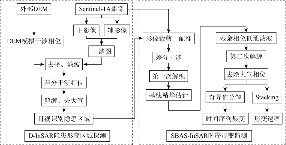
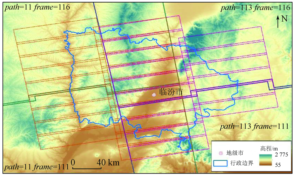
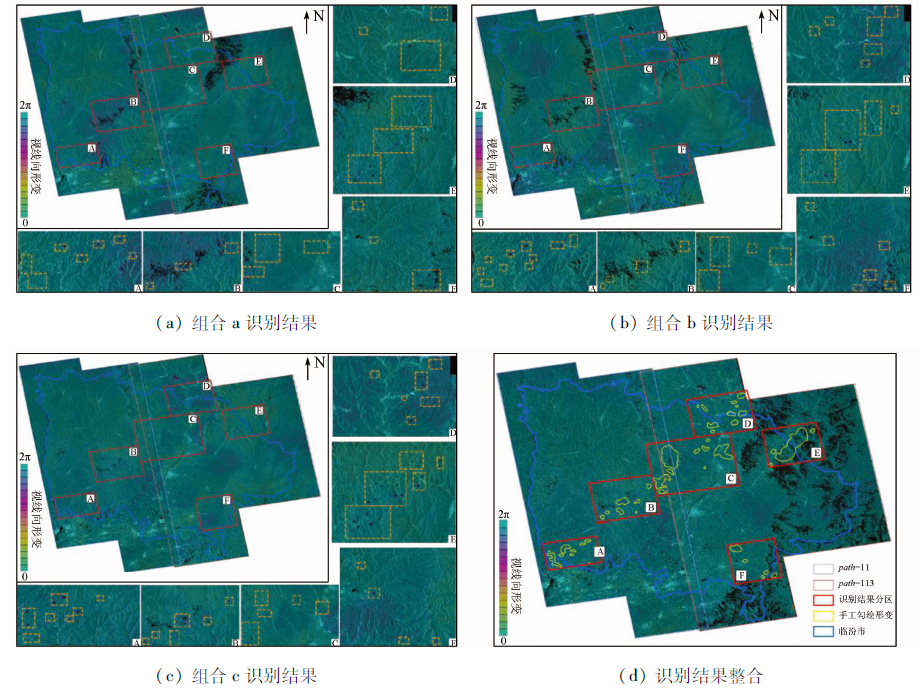
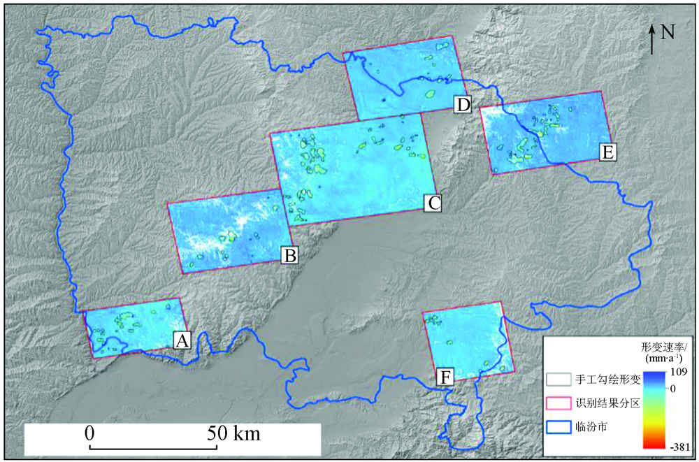
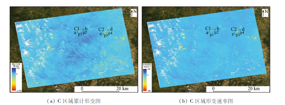
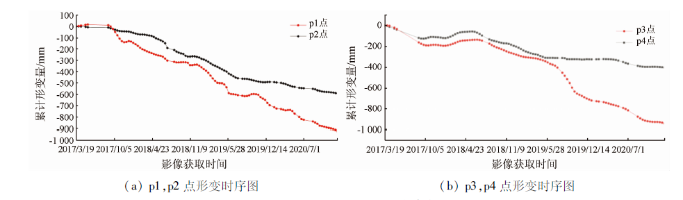
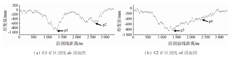
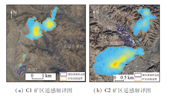
Abstract The ground subsidence caused by continuous mining in mining areas will seriously destroy the environment. There is an urgent need to quickly identify the locations and surface deformation of large-scope mining areas in the mining area monitoring. Given this, this study carried out large-scale detection and monitoring of the subsidence of mining areas in Linfen City using the synthetic aperture Radar interferometry (InSAR) technique. Firstly, by processing and analyzing 12 scenes of Sentinel 1A ascending data using the differential interferometric synthetic aperture Radar (D-InSAR) technique, this study conducted large-scale detection of subsidence disasters in mining areas in the study area. Then, this study processed 432 scenes of Sentinel 1A ascending data from different orbits using the small baseline subset InSAR (SBAS-InSAR) and monitored the obtained key areas. The results of this study show that there are a total of 105 subsidence areas in Linfen City, all of which are located in the mountains on both sides of the faulted Linfen basin. Further time-series deformation monitoring of key subsidence areas shows that many subsidence areas are continuously deforming, with high deformation amplitude and the deformation rate up to a maximum of -381 mm/a, and have caused huge damage to the ecological environment and infrastructure on the surface. The mining points near the subsidence area were identified according to optical images, thus verifying the reliability of the large-scale detection and monitoring method based on the InSAR technology. The results of this study will provide an important basis for the prevention and control of subsidence disasters in the mining areas of Linfen.
|
| Keywords
large-scale detection
D-InSAR
SBAS
deformation monitoring
|
|
|
|
Corresponding Authors:
ZHANG Shuangcheng
E-mail: 516832020@qq.com;shuangcheng369@chd.edu.cn
|
|
Issue Date: 21 September 2022
|
|
|
| [1] |
刘国林, 张连蓬, 成枢, 等. 合成孔径雷达干涉测量与全球定位系统数据融合监测矿区地表沉降的可行性分析[J]. 测绘通报, 2005(11):13-16.
|
| [1] |
Liu G L, Zhang L P, Cheng S, et al. Feasibility analysis of monitoring mining surface substance using InSAR/GPS data fusion[J]. Bulletin of Surveying and Mapping, 2005(11):13-16.
|
| [2] |
牛玉芬. SAR/InSAR技术用于矿区探测与形变监测研究[D]. 西安: 长安大学, 2015.
|
| [2] |
Niu Y F. SAR/InSAR technology used in mining area detection and deformation monitoring research[D]. Xi’an: Chang’an University, 2015.
|
| [3] |
朱建军, 杨泽发, 李志伟. InSAR矿区地表三维形变监测与预计研究进展[J]. 测绘学报, 2019, 48(2):135-144.
|
| [3] |
Zhu J J, Yang Z F, Li Z W. Recent progress in retrieving and predicting mining-induced 3D displace-ments using InSAR[J]. Acta Geodaetica et Cartographica Sinica, 2019, 48(2):135-144.
|
| [4] |
朱建军, 李志伟, 胡俊. InSAR变形监测方法与研究进展[J]. 测绘学报, 2017, 46(10):1717-1733.
|
| [4] |
Zhu J J, Li Z W, Hu J. Research progress and methods of InSAR for deformation monitoring[J]. Acta Geodaetica et Cartographica Sinica, 2017, 46(10):1717-1733.
|
| [5] |
张凯, 李全生, 戴华阳, 等. 矿区地表移动“空天地”一体化监测技术研究[J]. 煤炭科学技术, 2020, 48(2):207-213.
|
| [5] |
Zhang K, Li Q S, Dai H Y, et al. Research on integrated monitoring technology and practice of “space-sky-ground” on surface movement in mining area[J]. Coal Science and Technology, 2020, 48(2):207-213.
|
| [6] |
孙赫, 陈巍然, 牛玉芬, 等. 基于InSAR的矿区沉降中心动态变化监测与分析[J]. 大地测量与地球动力学, 2020, 40(3):276-280.
|
| [6] |
Sun H, Chen W R, Niu Y F, et al. Monitoring and analysis of dynamic change of mining subsidence center based on InSAR[J]. Journal of Geodesy and Geodynamics, 2020, 40(3):276-280.
|
| [7] |
刘志敏, 李永生, 张景发, 等. 基于SBAS-InSAR的长治矿区地表形变监测[J]. 国土资源遥感, 2014, 26(3):37-42.doi: 10.6046/gtzyyg.2014.03.06.
doi: 10.6046/gtzyyg.2014.03.06
|
| [7] |
Liu Z M, Li Y S, Zhang J F, et al. An analysis of surface deformation in the Changzhi mining area using small baseline InSAR[J]. Remote Sensing for Land and Resources, 2014, 26(3):37-42.doi: 10.6046/gtzyyg.2014.03.06.
doi: 10.6046/gtzyyg.2014.03.06
|
| [8] |
Ge L, Chang H C, Janssen V, et al. Integration of GPS,Radar interferometry and GIS for ground deformation monitoring[J]. GPS Solutions, 2003, 7(1):52-54.
doi: 10.1007/s10291-003-0048-4
url: http://link.springer.com/10.1007/s10291-003-0048-4
|
| [9] |
龙四春, 唐涛, 张赵龙, 等. DInSAR集成GPS的矿山地表形变监测研究[J]. 测绘通报, 2014(11):6-10.
|
| [9] |
Long S C, Tang T, Zhang Z L, et al. On mining ground deformation monitoring based on integration of DInSAR and GPS[J]. Bulletin of Surveying and Mapping, 2014(11):6-10.
|
| [10] |
蔡杰华, 张路, 董杰, 等. 九寨沟震后滑坡隐患雷达遥感早期识别与形变监测[J]. 武汉大学学报(信息科学版), 2020, 45(11):1707-1716.
|
| [10] |
Cai J H, Zhang L, Dong J, et al. Detection and monitoring of post-earthquake landslides in Jiuzhaigou using Radar remote sensing[J]. Geomatics and Information Science of Wuhan University, 2020, 45(11):1707-1716.
|
| [11] |
Rosen P A, Hensley S, Joughin I R, et al. Synthetic aperture Radar interferometry[J]. Proceedings of the IEEE, 2000, 88(3):333-382.
doi: 10.1109/5.838084
url: http://ieeexplore.ieee.org/document/838084/
|
| [12] |
李锁乐, 吴宏安, 张永红, 等. 包头市地面沉降高分辨率时序InSAR监测[J]. 测绘科学, 2018, 43(9):80-84.
|
| [12] |
Li S L, Wu H A, Zhang Y H, et al. Land subsidence monitoring in Baotou using high resolution time series InSAR technique from 2013 to 2015[J]. Science of Surveying and Mapping, 2018, 43(9):80-84.
|
| [13] |
廖明生, 王腾. 时间序列InSAR技术与应用[M]. 北京: 科学出版社, 2014.
|
| [13] |
Liao M S, Wang T. Time series InSAR technology and application[M]. Beijing: Science Press, 2014.
|
| [14] |
白泽朝, 靳国旺, 张红敏, 等. 天津地区Sentinel-1A雷达影像PSInSAR地面沉降监测[J]. 测绘科学技术学报, 2017, 34(3):283-288.
|
| [14] |
Bai Z C, Jin G W, Zhang H M, et al. Subsidence monitoring of Tianjin using PSInSAR technique with Sentinel-1A[J]. Journal of Geomatics Science and Technology, 2017, 34(3):283-288.
|
| [15] |
朱猛, 董少春, 尹宏伟, 等. 基于SBAS-InSAR方法的苏州地区2007—2010年地表形变时空变化研究[J]. 地球信息科学学报, 2016, 18(10):1418-1427.
doi: 10.3724/SP.J.1047.2016.01418
|
| [15] |
Zhu M, Dong S C, Yin H W, et al. Spatial-temporal ground deformation study of Suzhou area from 2007 to 2010 based on the SBAS InSAR method[J]. Journal of Geo-Information Science, 2016, 18(10):1418-1427.
|
| [16] |
Usai S. A least squares database approach for SAR interferometric data[J]. IEEE Transactions on Geoscience and Remote Sensing, 2003, 41(4):753-760.
doi: 10.1109/TGRS.2003.810675
url: http://ieeexplore.ieee.org/document/1202961/
|
| [17] |
沙永莲, 王晓文, 刘国祥, 等. 基于SBAS-InSAR的新疆哈密砂墩子煤田开采沉陷监测与反演[J]. 自然资源遥感, 2021, 33(3):194-201.doi: 10.6046/zrzyyg.2020026.
doi: 10.6046/zrzyyg.2020026
|
| [17] |
Sha Y L, Wang X W, Liu G X, et al. SBAS-InSAR-based monitoring and inversion of surface subsidence of the Shadunzi coal mine in Hami City,Xinjiang[J]. Remote Sensing for Natural Resources, 2021, 33(3):194-201.doi: 10.6046/zrzyyg.2020026.
doi: 10.6046/zrzyyg.2020026
|
| [18] |
李达, 邓喀中, 高晓雄, 等. 基于SBAS-InSAR的矿区地表沉降监测与分析[J]. 武汉大学学报(信息科学版), 2018, 43(10):1531-1537.
|
| [18] |
Li D, Deng K Z, Gao X X, et al. Monitoring and analysis of surface subsidence in mining area based on SBAS-InSAR[J]. Geomatics and Information Science of Wuhan University, 2018, 43(10):1531-1537.
|
| [19] |
李振洪, 宋闯, 余琛, 等. 卫星雷达遥感在滑坡灾害探测和监测中的应用:挑战与对策[J]. 武汉大学学报(信息科学版), 2019, 44(7):967-979.
|
| [19] |
Li Z H, Song C, Yu C, et al. Application of satellite Radar remote sensing to landslide detection and monitoring:Challenges and solutions[J]. Geomatics and Information Science of Wuhan University, 2019, 44(7):967-979.
|
| [20] |
Usai S, Klees R. SAR interferometry on a very long time scale:A study of the interferometric characteristics of man-made features[J]. Geoscience & Remote Sensing IEEE Transactions on, 1999, 37(4):2118-2123.
|
| [21] |
马秀秀, 王雅萍, 程结海, 等. 临汾市近20年植被覆盖度遥感估算及动态变化分析[J]. 能源与环保, 2019, 41(11):11-18.
|
| [21] |
Ma X X, Wang Y P, Cheng J H, et al. Remote sensing estimation and dynamic change analysis of vegetation coverage in Linfen City in recent 20 years[J]. China Energy and Environmental Protection, 2019, 41(11):11-18.
|
| [22] |
赵振斌, 韩军青, 陈硕. 临汾市地质灾害及其危害性分析[J]. 山西师范大学学报(自然科学版), 2016, 30(2):117-123.
|
| [22] |
Zhao Z B, Han J Q, Chen S. Analysis of geological disasters and its harmfulness in Linfen[J]. Journal of Shanxi Normal University(Natural Science Edition), 2016, 30(2):117-123.
|
|
Viewed |
|
|
|
Full text
|
|
|
|
|
Abstract
|
|
|
|
|
Cited |
|
|
|
|
| |
Shared |
|
|
|
|
| |
Discussed |
|
|
|
|
 2022,
Vol. 34
2022,
Vol. 34