|
|
 |
|

|
|
|
A comparative study of the identification of hidden landslide hazards based on time series InSAR techniques |
DONG Jihong1,2( ), MA Zhigang3(), LIANG Jingtao1, LIU Bin1, ZHAO Cong1, ZENG Shuai3, YAN Shengwu1, MA Xiaobo1 ), MA Zhigang3(), LIANG Jingtao1, LIU Bin1, ZHAO Cong1, ZENG Shuai3, YAN Shengwu1, MA Xiaobo1 |
1. Evaluation and Utilization of Strategic Rare Metals and Rare Earth Resource Key Laboratory of Sichuan Province, Sichuan Geological Survey, Chengdu 610081, China
2. Sichuan Intelligent Geological Big Data Co., Ltd., Chengdu 610081, China
3. Sichuan Institute of Land and Space Ecological Restoration and Geohazards Prevention, Chengdu 610081, China |
|
|
|
|
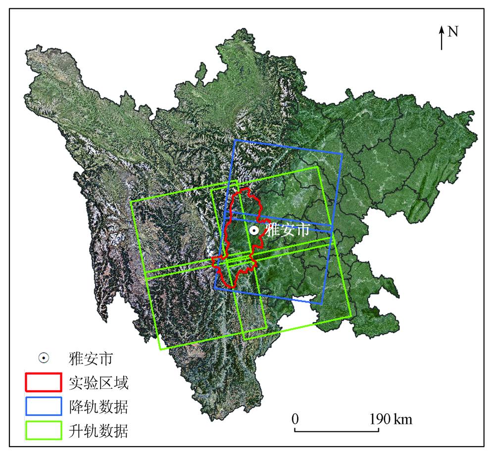
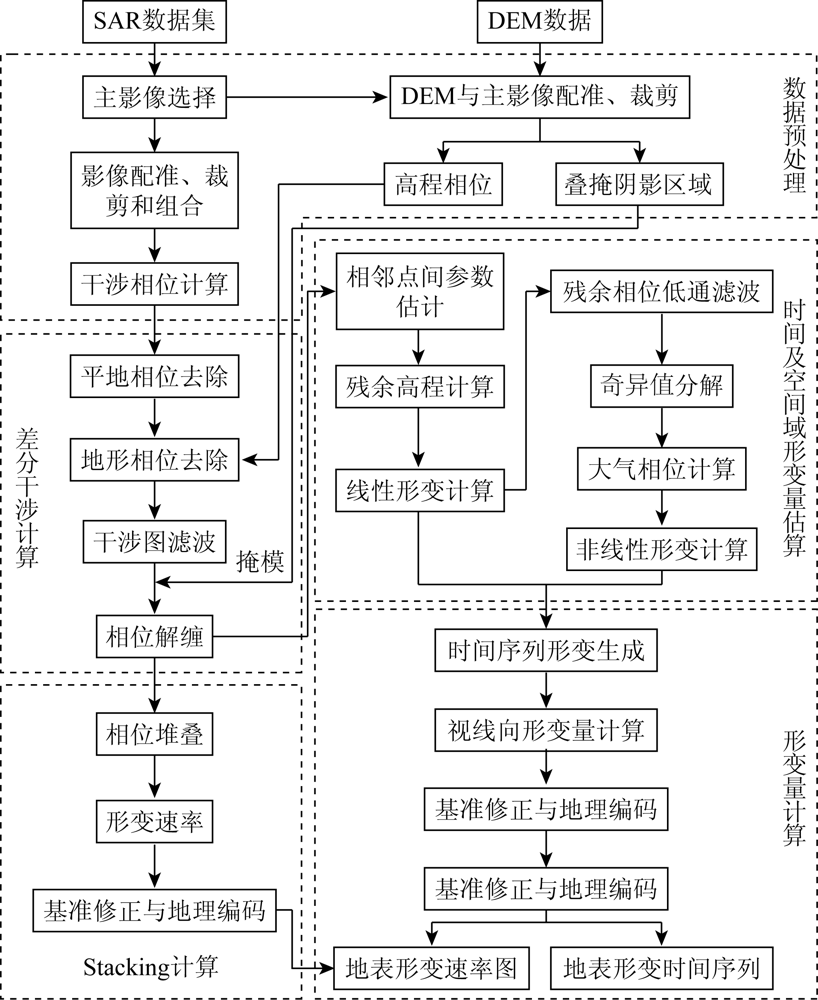
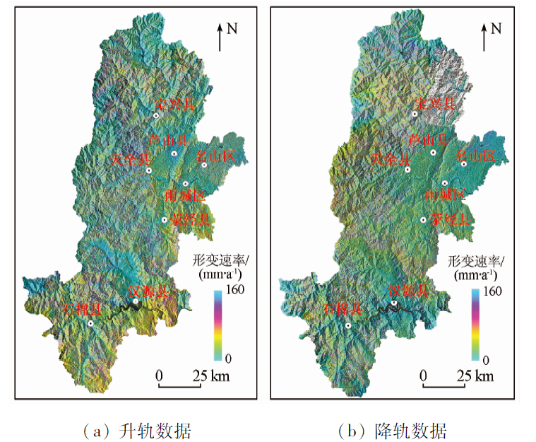
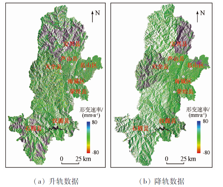
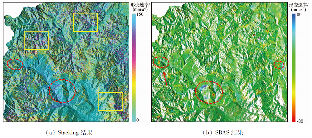
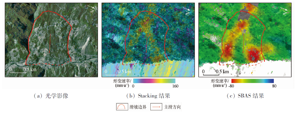
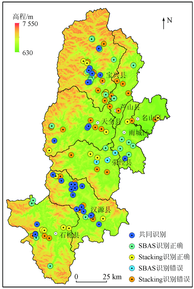
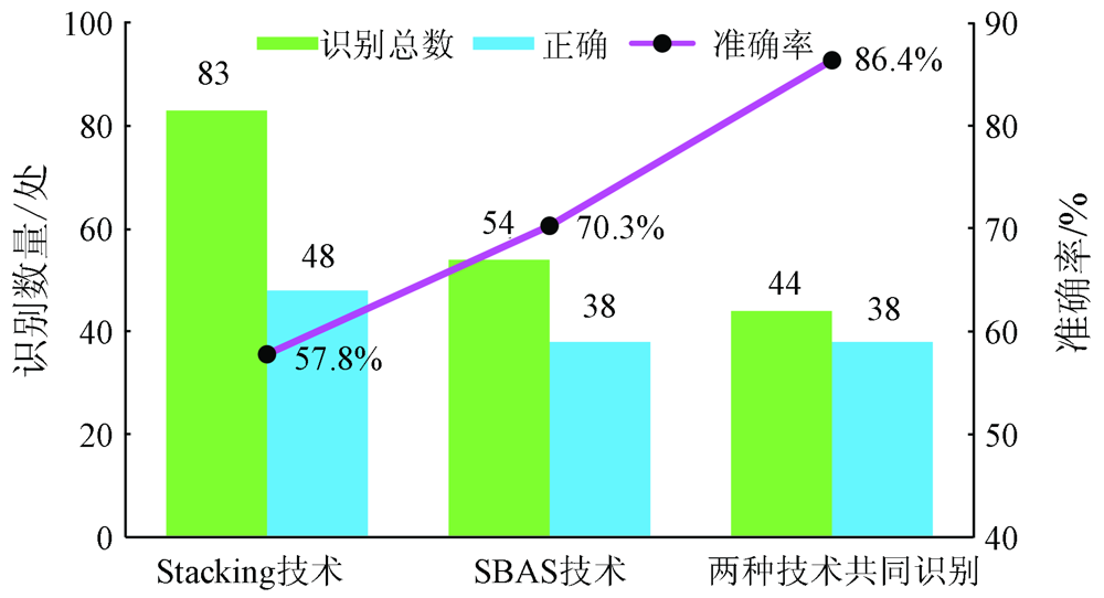
Abstract The spaceborne interferometric synthetic aperture Radar (InSAR) techniques have been widely used in geological disaster monitoring at present due to their advantages of non-contact, large scope, wide space coverage, and high monitoring accuracy. With Ya’an City with dense vegetation as the experimental area, this study comparatively analyzed the identification of hidden landslide hazards based on time series InSAR techniques (stacking and SBAS). By comparing the surface deformation rate maps obtained using different time series InSAR techniques based on the Sentinel-1 data, it was found that the results of the SBAS technique were less vulnerable to various errors and achieved better monitoring results than the Stacking technique. The statistical analyses of hidden landslide hazards interpreted from the surface deformation rate map, as well as the field survey results, revealed that more hidden hazards were identified using the Stacking technique than those identified using the SBAS technique, while the SBAS technique yielded higher accuracy than the Stacking technique. Therefore, it is recommended to combine SBAS and Stacking techniques to carry out the early identification of landslide hazards in Ya’an City.
|
| Keywords
landslide
identification of hidden hazards
time series InSAR technique
Ya’an City
|
|
|
|
Corresponding Authors:
MA Zhigang
E-mail: 1767095201@qq.com;18149262@qq.com
|
|
Issue Date: 21 September 2022
|
|
|
| [1] |
殷跃平. 中国地质灾害减灾战略初步研究[J]. 中国地质灾害与防治学报, 2004, 15(2):4-11.
|
| [1] |
Yin Y P. Initial study on the hazard-relief strategy of geological hazard in China[J]. The Chinese Journal of Geological Hazard and Control, 2004, 15(2):4-11.
|
| [2] |
廖明生, 董杰, 李梦华, 等. 雷达遥感滑坡隐患识别与形变监测[J]. 遥感学报, 2021, 25(1):332-341.
|
| [2] |
Liao M S, Dong J, Li M H, et al. Radar remote sensing for potential landslides detection and deformation monitoring[J]. National Remote Sensing Bulletin, 2021, 25(1):332-341.
|
| [3] |
王海波. 雅安市石棉县后沟尾矿库泥石流防治工程研究[D]. 成都: 西南交通大学, 2017.
|
| [3] |
Wang H B. Study on debris flow prevention and control project of tailing ditch in Shimian County of Ya’an[D]. Chengdu: Southwest Jiao Tong University, 2017.
|
| [4] |
殷跃平, 王文沛, 张楠, 等. 强震区高位滑坡远程灾害特征研究——以四川茂县新磨滑坡为例[J]. 中国地质, 2017, 44(5):827-841.
|
| [4] |
Yin Y P, Wang W P, Zhang N, et al. Study on the characteristics of remote disasters of high-location landslides in strong earthquake areas:Taking Xinmo landslide in Maoxian County,Sichuan Province as an example[J]. Chinese Geology, 2017, 44(5):827-841.
|
| [5] |
Su L J, Hu K H, Zhang W F, et al. Erratum to:Characteristics and triggering mechanism of Xinmo landslide on 24 June 2017 in Sichuan,China[J]. Journal of Mountain Science, 2017, 14(10):2134-2135.
doi: 10.1007/s11629-017-4568-8
url: https://doi.org/10.1007/s11629-017-4568-8
|
| [6] |
许强, 李为乐, 董秀军, 等. 四川茂县叠溪镇新磨村滑坡特征与成因机制初步研究[J]. 岩石力学与工程学报, 2017, 36(11):2612-2628.
|
| [6] |
Xu Q, Li W L, Dong X J, et al. The Xinmocun landslide on June 24,2017 in Maoxian,Sichuan:Characteristics and failure mechanism[J]. Chinese Journal of Rock Mechanics and Engineering, 2017, 36(11):2612-2628.
|
| [7] |
许强, 郑光, 李为乐, 等. 2018年10月和11月金沙江白格两次滑坡——堰塞堵江事件分析研究[J]. 工程地质学报, 2018, 26(6):1534-1551.
|
| [7] |
Xu Q, Z G, Li W L, et al. Study on successive landslide damming events of Jinsha River in Baige Village of Octorber 11 and November 3,2018[J]. Journal of Engineering Geology, 2018, 26(6):1534-1551.
|
| [8] |
Liu X, Zhao C, Zhang Q, et al. Deformation of the Baige landslide,Tibet,China,Revealed through the integration of cross-platform ALOS/PALSAR-1 and ALOS/PALSAR-2 SAR observations[J]. Geophysical Research Letters, 2020, 47(3),e2019GL086142.
|
| [9] |
杨成生, 董继红, 朱赛楠, 等. 金沙江结合带巴塘段滑坡群InSAR探测识别与形变特征[J]. 地球科学与环境学报, 2021, 43(2):398-408.
|
| [9] |
Yang C S, Dong J H, Zhu S N, et al. Detection,identification and deformation characteristics of landslide groups by InSAR in Batang section of Jinsha River convergence zone,China[J]. Journal of Earth Sciences and Environment, 2021, 43(2):398-408.
|
| [10] |
Ao M, Zhang L, Dong Y, et al. Characterizing the evolution life cycle of the Sunkoshi landslide in Nepal with multi-source SAR data[J]. Scientific Reports, 2020, 10(1):1-12.
doi: 10.1038/s41598-019-56847-4
url: https://doi.org/10.1038/s41598-019-56847-4
|
| [11] |
赵超英, 刘晓杰, 张勤, 等. 甘肃黑方台黄土滑坡InSAR识别、监测与失稳模式研究[J]. 武汉大学学报(信息科学版), 2019, 44(7):996-1007.
|
| [11] |
Zhao C Y, Liu X J, Zhang Q, et al. Research on loess landslide identification,monitoring and failure mode with InSAR technique in Heifangtai,Gansu[J]. Geomatics and Information Science of Wuhan University, 2019, 44(7):996-1007.
|
| [12] |
刘星洪, 姚鑫, 於开炳, 等. 川藏高速巴塘—芒康段地质灾害遥感综合早期识别研究[J]. 工程科学与技术, 2020, 52(6):49-60.
|
| [12] |
Liu X H, Yao X, Yu K B, et al. Remote sensing integrated identification of geological hazards in the Batang-Mangkang section of the Sichuan-Tibet Highway[J]. Advanced Engineering Sciences, 2020, 52(6):49-60.
|
| [13] |
韩冬建, 杨成生, 董继红. 西藏樟木口岸震后滑坡灾害变形InSAR监测分析[J]. 地质力学学报, 2020, 26(4):565-574.
|
| [13] |
Han D J, Yang C S, Dong J H. InSAR monitoring and analysis of landslide deformation after the earthquake in Zhangmu Port,Tibet[J]. Journal of Geomechanics, 26(4):565-574.
|
| [14] |
韩冰. 雅安地区滑坡灾害监测预警研究[D]. 北京: 中国地质大学(北京), 2016.
|
| [14] |
Han B. Research on landslide monitoring and early warning in Ya’an area[D]. Beijing: China University of Geosciences(Beijing), 2016.
|
| [15] |
李树林, 余利峰, 陈丽霞. 雅安芦山县地震崩塌滑坡信息提取与发育规律分析[J]. 工程地质学报, 2014, 22(5):861-868.
|
| [15] |
Li S L, Yu L F, Chen L X. Extaction and analysis of Lushan eathquake triggered landsides a case study in Baosheng Town,Ya’an City[J]. Journal of Engineering Geology, 2014, 22(5):861-868.
|
| [16] |
Chen Y, Li Z, Penna N T, et al. Generic atmospheric correction model for interferometric synthetic aperture Radar observations[J]. Journal of Geophysical Research:Solid Earth, 2018, 123(10):9202-9222.
doi: 10.1029/2017JB015305
url: https://onlinelibrary.wiley.com/doi/10.1029/2017JB015305
|
| [17] |
刘国祥, 陈强, 罗小军, 等. InSAR原理与应用[M]. 北京: 科学出版社, 2019.
|
| [17] |
Liu G X, Chen Q, Luo X J, et al. Principles and applications of InSAR[M]. Beijing: Science Press, 2019.
|
| [18] |
李晓恩, 周亮, 苏奋振, 等. InSAR技术在滑坡灾害中的应用研究进展[J]. 遥感学报, 2021, 25(2):614-629.
|
| [18] |
Li X E, Zhou L, Su F Z, et al. Application of InSAR technology in landslide hazard:Progress and prospects[J]. National Remote Sensing Bulletin, 2021, 25(2):614-629.
|
| [19] |
史绪国, 张路, 许强, 等. 黄土台塬滑坡变形的时序InSAR监测分析[J]. 武汉大学学报(信息科学版), 2019, 44(7):1027-1034.
|
| [19] |
Shi X G, Zhang L, Xu Q, et al. Monitoring slope displacements of loess terrace using time series InSAR analysis technique[J]. Geomatics and Information Science of Wuhan University, 2019, 44(7):1027-1034.
|
| [20] |
Tazio S, Jan K, Holger F, et al. Satellite SAR interferometry for the improved assessment of the state of activity of landslides:A case study from the Cordilleras of Peru[J]. Remote Sensing of Environment, 2018, 217:111-125.
doi: 10.1016/j.rse.2018.08.014
url: https://linkinghub.elsevier.com/retrieve/pii/S0034425718303791
|
| [21] |
Kursah M B, Wang Y, Bayoh H D, et al. A comparative study on the predictive ability of archived and SBAS-InSAR inventories for landslide susceptibility using frequency ratio model in western area,Sierra Leone[J]. Environmental Earth Sciences, 2021, 80(10):1-18.
doi: 10.1007/s12665-020-09327-2
url: https://doi.org/10.1007/s12665-020-09327-2
|
| [22] |
Berardino P, Fornaro G, Lanari R, et al. A new algorithm for surface deformation monitoring based on small baseline differential SAR interferograms[J]. IEEE Transactions on Geoscience & Remote Sensing, 2002, 40(11):2375-2383.
|
| [23] |
Sandwell D T, Price E J. Phase gradient approach to stacking interferograms[J]. Journal of Geophysical Research Solid Earth, 1998, 103(B12):30183-30204.
|
| [24] |
Funning G J, Burgmann R, Ferretti A, et al. Kinematics,asperities and seismic potential of the Hayward fault,California from ERS and RADARSAT PS-InSAR[C]// Agu Fall Meeting, 2005.
|
| [25] |
Xiao R Y, Yu C, Li Z H, et al. General survey of large-scale land subsidence by GACOS-Corrected InSAR stacking:Case study in North China Plain[J]. Proceedings of the International Association of Hydrological Sciences, 2020,382.
|
|
Viewed |
|
|
|
Full text
|
|
|
|
|
Abstract
|
|
|
|
|
Cited |
|
|
|
|
| |
Shared |
|
|
|
|
| |
Discussed |
|
|
|
|
 2022,
Vol. 34
2022,
Vol. 34